Kirkintilloch,East Dunbartonshire, Scotland, UK 作者: 来源: 发布时间:2021-07-28
I. Population and Area
Continent: Europe
Country: The U.K
State/Province: Scotland
City/Town: Kirkintilloch,East Dunbartonshire
Total Area: 2.19 (sq mi)
Population in 2018: 19.7 (thousand)
Reference Website:
https://www.google.com/search?source=hp&ei=KNEnWqOFIIGu0gS2zZzYDQ&q=Kirkintilloch%EF%BC%8CEast%20Dunbartonshire
II. Natural Geography (environment and resources)
Geography
As well as the Forth and Clyde Canal the Luggie Water passes through Kirkintilloch, the canal crossing the Luggie on an aqueduct. The Luggie flows into the River Kelvin which in turn flows into the River Clyde in Glasgow. Communities in and around Kirkintilloch include: Cleddans; Harestanes; Hayston; Hillhead; Oxgang; Rosebank; Langmuir; Greens; Fauldhead; Waterside; Westermains; Lenzie: Gallowhill: Whitegates; Back O' Loch; Woodilee; Broomhill etc.
Location
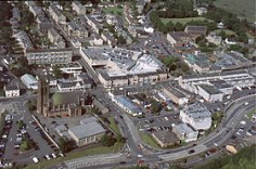
Kirkintilloch is a town and former barony burgh in East Dunbartonshire, Scotland. It lies on the Forth and Clyde Canal and on the south side of Strathkelvin, about 8 miles (13 km) northeast of central Glasgow. Historically part of Dunbartonshire, the town is the administrative centre of the East Dunbartonshire council area, and its population in 2009 was estimated at 19,700.
Transport
The East Dunbartonshire Local Transport Strategy 2020-2025 is a detailed vision for enhancing transport and travel in East Dunbartonshire. Enhancing the transport network is a key driver for: improving the local economy, improving the environment, increasing social inclusion and delivering health benefits for all residents and visitors of East Dunbartonshire. The Local Transport Strategy (LTS) sets out the Council’s policy on transport, presents Transport Planning Objectives and coordinates future priorities through a series of actions and interventions for active travel, public transport, roads and parking in East Dunbartonshire and beyond. The LTS has been produced following a comprehensive process that ensured local issues and opportunities were identified at an early stage to allow a detailed action plan to be put in place that will aim to provide positive solutions for all. The review of evidence, policy, route corridor studies and consultations related to transport in East Dunbartonshire is all detailed within the Background Report which can be downloaded from the Documents section at the bottom of this webpage. This evidence review allowed a number of Transport Planning Objectives to be derived which provide a direction for the LTS to follow. A number of options were then generated and compiled within a Transport Options Report which can also be accessed in the Documents section. A period of consultation on the Transport Options Report informed the development of a Draft LTS which was also subject to a further period of consultation. The outcomes of the Transport Options Report and Draft LTS consultations can be viewed in the Background Report and Draft LTS Report of Consultation respectively.
III. Economy
East Dunbartonshire Council Teacher yearly salaries in Kirkintilloch, Scotland
Salary estimated from 14 employees, users, and past and present job advertisements on Indeed in the past 36 months.
Average salary
£35,891 per year
14% Above national average
Salary Distribution
£18,000
£55,000
More East Dunbartonshire Council Education & Instruction salaries
AVERAGE SALARY
SALARY DISTRIBUTION
Early Years Educator
7 salaries reported
£25,483 per year
£11,000
£69,000
Principal
13 salaries reported
£44,807 per year
£11,000
£69,000
High School Teacher
6 salaries reported
£40,316 per year
£11,000
£69,000
School Principal
9 salaries reported
£54,758 per year
£11,000
£69,000
French Teacher
7 salaries reported
£32,808 per year
£11,000
£69,000
The Economic Development service leads on a range of programmes and services to support sustainable economic growth, active travel, public transport and tourism.
The service delivers the following core elements of activity:
·Business and Tourism
·Strategic Development and Regeneration
·Transport and Access
·Mugdock Country Park
One of the main challenges in East Dunbartonshire is economic growth and recovery. Although employment and economic activity rates are high, the East Dunbartonshire workforce is heavily reliant on the wider economy of surrounding areas. There is consensus that more needs to be done to encourage economic development within East Dunbartonshire in order to decrease the reliance on the surrounding economy for employment opportunities.
Attracting inward investment by making accessible and attractive business locations and premises available in the area would go some way to address this situation and ensure more local jobs are available for residents.
Reference Website:
https://www.indeed.co.uk/cmp/East-Dunbartonshire-Council/salaries/Teacher/Kirkintilloch-SCT
https://www.eastdunbarton.gov.uk/business/economic-development
IV. Industrial Characterisitics
Major industries:
The town was one of the hotbeds of the Industrial Revolution in Scotland, beginning with the emergence of a booming textile industry in the area. There were 185 weavers in Kirkintilloch by 1790, and in 1867 James Slimon's cotton mill at Kelvinside employed 200 women. With the construction of the Forth and Clyde Canal through the town in 1773, and the establishment of the Monkland and Kirkintilloch Railway in 1826, Kirkintilloch developed further as an important transportation hub, inland port and production centre for iron, coal, nickel and even small ships. This industrial heritage lives on in the town's designation as the "Canal Capital of Scotland", and in the redevelopment of the canal and surrounding former industrial sites in the early 21st century.
By the 20th century, the principal employers in the town were the shipbuilders J & J Hay and Peter McGregor, and the Lion (1880–1984) and Star foundries, all of which produced goods for the domestic market and for export around the world. Kirkintilloch's most famous exports were the distinctive red British postboxes and phoneboxes K2 to K6, produced in the town until 1984 and still to be found as far afield as Taiwan and Mississippi. Listed versions of these boxes still stand at the foot of Alexandra Street in the centre of Kirkintilloch.
Major projects and related introductions:
Regeneration project:
The construction of the new leisure centre came in combination with a wider-ranging artistic, cultural and social regeneration project called Kirkintilloch's Initiative. This includes the new link road largely funded by housebuilders developing on the site of the former Woodilee Hospital.
Kirkintilloch Learning Centre is located on Southbank Road, overlooking the Forth and Clyde Canal, an offshoot of Cumbernauld College.
V. Attractions
1. The Auld Kirk Museum:
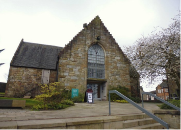
Good museum that tells the story of Kirkintilloch through the years, from Roman to present times. Loads of things to do for an hour or so. Set in an old church as can be guessed from the name. Small but well kept. Free admission. Go if you're in the town.
2. St Mary's Parish Church:
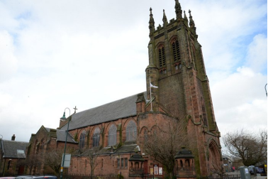
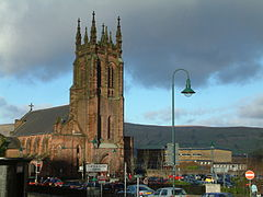
Beautiful Old church which has been very well looked after over the years unlike the newer churches it has loads of character.
3. Kirkintilloch War Memorial:
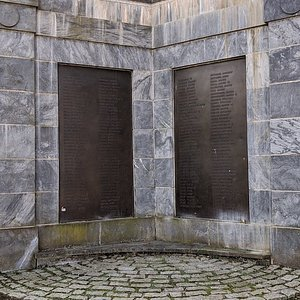
The monument forms a gated entrance to Peel Park. The gate is monumental in size and covered in a facade of pale blue marble panels The outer part of the gate has four bronze plaques dedicated to WWI, which gate facing the park has two plaques for WWII.
Reference Website:
https://www.tripadvisor.com/Attractions-g186522-Activities-Kirkintilloch_East_Dunbartonshire_Scotland.html
VI. History
The first known settlement on the site of what is now Kirkintilloch was a Roman fort established in what is now the Peel Park area of the town. Dating from the mid-2nd century, the Antonine Wall, one of the northernmost frontiers in Roman Britannia was routed through Kirkintilloch; its course continues through the centre of the town to this day, although little trace can now be seen above ground.A digital reconstruction of the fort has been created. There are many archeological artifacts found in Kirkintilloch on display at the Hunterian Museum in Glasgow. There is no strong evidence of habitation on the site for the following thousand years until Clan Cumming established a castle (Motte and Bailey) and church there in the 12th century. A small settlement grew and was granted burgh status in 1211, becoming an important staging post for west–east journeys from Glasgow to eastern and north-eastern Scotland. From this time, a weekly market was held in the town, probably at the foot of Peel Brae (along with High Street and Cowgate, one of the three medieval thoroughfares in the town). The castle was of some importance during the wars of independence when an English garrison was stationed there, commanded by Sir Philip de Moubray, who was later to command Stirling Castle at the time of the Battle of Bannockburn. Soldiers from the castle were dispatched to arrest William Wallace at Robroyston in 1305 and escorted him to Dumbarton Castle. Later the same year, the garrison is recorded as having sent a petition to King Edward of England complaining of non-payment of wages. The castle was attacked by Scottish forces in 1306 under Bishop Wishart of Glasgow (using timber given to Glasgow diocese by the English for cathedral repairs), but the siege was unsuccessful. The castle is thought to have been destroyed on the orders of Robert Bruce later in the conflict, although the traces of a mot surrounded by a ditch can still be seen in the Peel Park.
The original Cumming parish church, St Ninian's, was constructed around 1140 some distance to the east of the town (where some of the stones remain in the form of an 18th-century watchtower at the entrance to the Auld Aisle Cemetery) as Kirkintilloch was originally in the parish of Lenzie which stretched from Cumbernauld in the East to Kirkintilloch in the West. The establishment was part of the endowment of Cambuskenneth Abbey, and was accompanied by a grant of one oxgang of land (approximately 15 acres), the measurement that lent its name to the area near the church. A chapel to the Virgin Mary was established in the town itself, sometime before 1379, and was endowed with land at Duntiblae by Sir David Fleming. The move of the parish church to the site of the chapel at Kirkintilloch Cross (now the Auld Kirk Museum) in 1644 resulted in a split of the Parish into Easter and Wester Lenzie (later Cumbernauld and Kirkintilloch Parishes) The name Lenzie was later reused for Kirkintilloch's railway station on the main Glasgow to Edinburgh line, around which the later village of that name developed.
VII. Culture
Kirkintilloch Town Hall was opened in 1906, paid for by public subscription. Listed as a building of special architectural or historic interest, it was closed by East Dunbartonshire Council in June 2004, largely due to the anticipated expense of restoring a building constructed of notoriously crumbling soft sandstone. In response the Kirkintilloch Town Hall Preservation Trust was established as a registered charity to preserve the hall and restore it for community use. Work began on the redevelopment of the hall in early summer 2016, with major works completed in October 2017. Kirkintilloch Town Hall officially reopened in November 2018.
The town is served by the William Patrick Library, which moved from a converted private villa near Peel Park to a new building on West High Street in the 1990s. The titular William Patrick was a local minister whose brother donated funds to the local people to have a library founded in William's name. The neglected old library was sold by the council back into private ownership and returned to residential use after restoration works. William Patrick Library is the main library for East Dunbartonshire Council and also houses the reference department and other council offices including social services, planning and a new community hub.
Kirkintilloch underwent significant population growth in the post-Second World War period, with several new amenities erected to cater for the growing population of the town and its surrounding villages. New shopping facilities were built in the Cowgate and Townhead areas, culminating in the opening, by Diana, Princess of Wales, of the Regent Centre shopping mall in the 1990s.
The local swimming pool and Community Education Centre, built in the 1960s and '70s in Woodhead Park to the south of the town, were demolished in 1999 and 2005 respectively. Woodhead Park was once home to a petting zoo, bandstand, greenhouses, putting green and public toilets. All are now closed, although a new leisure centre was opened on the same spot as the old pool in July 2007, providing facilities for tennis, badminton, swimming, football and a gymnasium. A large new children's play area has been created near the site of the former putting green in the park.
The construction of the new leisure centre came in combination with a wider-ranging artistic, cultural and social regeneration project called Kirkintilloch's Initiative. This includes the new link road largely funded by housebuilders developing on the site of the former Woodilee Hospital.
Kirkintilloch Learning Centre is located on Southbank Road, overlooking the Forth and Clyde Canal, an offshoot of Cumbernauld College.
Locally, a G66+ Live! Cultural festival offers a wide range of events from talks on history in local churches to musical events in the town's local bars, such as Bar Bliss, dramas and also entries from the schools in the G66 postcode area. G66+ Live! is annual festival taking place in June. Kirkintilloch's most successful musical ensemble is its brass band, the Kirkintilloch Band, who were crowned Scottish Brass Band Champions in 2007 and who have had success in competitions both in Scotland and further afield. Each August the local Canal Festival takes place.
An amateur theatre group, the Kirkintilloch Players, is based at the Turret Theatre in the Eastside area of Kirkintilloch, the former home of the town's Liberal Club.
The town has a pipe band of the same name, Kirkintilloch Pipe Band. Established on 12 November 1888 it is one of, if not the oldest civilian pipe band in the world. The band takes part in civic and private events in the local and surrounding areas and also takes part in competition. Its pipers and drummers are mostly from the local area and the band still practises weekly in the Hillhead Community Centre.
VIII. Other information
There are six primary schools in Kirkintilloch, which are Hillhead, Harestanes, Oxgang, Gartconner, Lairdsland and Holy Family. There are also two schools in the area for children with special needs, these being Merkland School in Hillhead and Campsie View School in Lenzie.
The two secondary schools in the area are Kirkintilloch High School (Non-denominational) and St Ninian's High School (Roman Catholic) Both schools recently constructed new-build campuses, which were completed in August 2009.
In the Lenzie area primary schools include Lenzie Meadow Primary, Millersneuk and Holy Family Primary. Holy Family is a Catholic school on the edge of Lenzie on the border with Kirkintilloch, and is a feeder to St Ninian's High School. The other two non-denomination schools in the area feed onto Lenzie Academy, along with Lairdsland Primary in Kirkintilloch and the nearby Auchinloch Primary.
IX. Contact information
Mayor/Officer: Alan Brown
Tel: 0141 578 8016
Mail: alan.brown@eastdunbarton.gov.uk
Reference Website:
https://www.eastdunbarton.gov.uk/councillor/councillor-alan-brown
