Morpeth, Northumberland, England, UK 作者: 来源: 发布时间:2021-01-13
I. Population and Area
Continent: Europe
Country: The U.K
State/Province: England
City/Town: Morpeth, Northumberland
Total Area: 4.42 (sq mi)
Population in 2011: 14.017(thousand)
II. Natural Geography (environment and resources)

Cockle Park, located slightly north of Morpeth, contains a Met Office weather station, founded in 1897. The following table shows the climate data of the station from 1971–2000, recorded at 95 metres (312 ft) elevation:
Transport
The A1, the longest numbered road in the UK, used to pass through Morpeth until the bypass was opened in 1970. Morpeth's railway station is on the main East Coast Main Line which runs between London and Edinburgh. To the south of the station is a sharp curve which has been the scene of several train crashes.A non-passenger line operates between Morpeth and Bedlington. A former line, closed in 1966, ran west from Morpeth to Scots Gap (from where there was a branch line to Rothbury), then west to Redesmouth, and lastly south to Hexham.[
III. Economic Condition
Average people per household: 2.3
Median weekly household income: $1,111
IV. Industrial Characterisitics
Major industries:For about a century the Tyneside (now Tyne and Wear) chemical industries were among the most important in the country, but, like the glassworks, they failed to survive. During the late 20th century the heavy industries of the Tyne and Blyth valleys declined, and coal mining ceased, except for a single mine at Ellington. That mine, however, closed in 2005.
Big project:NCEL
Details: Stobhill-based Northumberland Community Enterprise Ltd (NCEL) is seeking the money for its Family Chances initiative that will provide local families with a free school uniform bank, suits and work wear for jobseekers, free haircuts, a job club, a community pantry and a household paint recycling scheme.
V. Attractions
1. Wallington Hall:

The house, which was the first National Trust donation, is a treasure too having been lived in by the Trevelyan family who were great collectors of Art, books & curiosities.
2. Druridge Bay Country Park:

Fantastic beach with lovely views, lake with water sports, children’s play area, grassy areas, nice walks, multiple car parks, cafe and toilets
3. Northumberland Country Zoo:

Reference Website:
https://www.tripadvisor.co.uk/Attractions-g504049-Activities-Morpeth_Northumberland_England.html
VI. History
Morpeth was founded at a crossing point of the River Wansbeck. Remains from prehistory are scarce, but the earliest evidence of occupation found is a stone axe thought to be from the Neolithic period. There is a lack of evidence of activity during the Roman occupation of Britain, although there were probably settlements in the area at that time. Morpeth is recorded in the Assize Rolls of Northumberland of 1256 as Morpath and Morthpath, and was also archaically spelt Morepath. The meaning of the town's name is uncertain; "moor path" has been suggested in reference to its historical position on the main road from England to Scotland, with the marshes around the modern-day Carlisle Park having been suggested to be the "moor" in question.[8] Another possible meaning is that the name derives from the Old English pre-7th-century compound morð-pæð or Morthpaeth, meaning "murder path", in remembrance of "some forgotten" slaying on the road, although some old documents suggest that this meaning is a fallacy.
VII. Culture
Church of England
The ancient Church of England parish church of Morpeth is St Mary's at High Church, which was the main Anglican place of worship in the area until the 1840s.The church is mostly in the 14th century style.] The grave of Emily Wilding Davison lies in St Mary's graveyard.
In 1843, a public meeting was called to address the lack of attendance at the church, and it was found that the walk to the current church, on the southern edge of the town, was too much for many of the parishioners. From this meeting, it was decided to build a new church in the town centre and accordingly, the church of St James the Great was consecrated for worship on 15 October 1846. Benjamin Ferrey designed the church in a "Neo-Norman" style, based on the 12th century Monreale Cathedral, Sicily.
A third parish church, St Aidan's, was founded as a mission church in 1957, located on the Stobhill estate on the south-east of the town.

Roman Catholic Church
Morpeth's Roman Catholic Church, dedicated to St Robert of Newminster, was built off Oldgate on land adjacent to Admiral Lord Collingwood's house. It opened on 1 August 1850 and was consecrated by the Right Reverend, William Hogarth, Bishop of Samosata (later Bishop of Hexham). Collingwood House is now the presbytery (residence) for the priest in charge of the Church.
VIII. Other information
Landmarks
Town centre of Morpeth
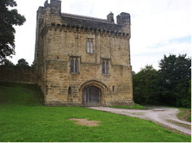
The historical layout of central Morpeth consisted of Bridge Street, Oldgate Street and Newgate Street, with burgage plots leading off them. Traces of this layout remain: Old Bakehouse Yard off Newgate Street is a former burgage plot, as is Pretoria Avenue, off Oldgate. The town stands directly on what used to be the Great North Road, the old coaching route between London and Edinburgh.
Carlisle Park and a coat of arms. A statue of Emily Wilding Davison commemorating 100 years since women were given the right to vote. Carlisle Park is located on the southern bank of the River Wansbeck in Morpeth. The park has the William Turner Garden, one of the only four floral clocks in England, a statue of Emily Wilding Davison, as well as other facilities and attractions. Morpeth's Mafeking Park, at the bottom of Station Bank, was unsuccessfully put forward by locals to be listed as the smallest park in the world in the Guinness Book of Records.
IX. Contact information
Mayor/Officer: David Bawn
Tel: 01670 514314
Mail:mayor@morpeth-tc.gov.uk
