Burnley, Lancashire, England, UK 作者: 来源: 发布时间:2020-12-31
I. Population and Area
Continent: Europe
Country: The U.K
State/Province: England
City/Town: Burnley, Lancashire
Total Area: 6.108 (sq mi)
Population in 2018: 88.53(thousand)
II. Natural Geography (environment and resources)

The town lies in a natural three-forked valley at the confluence of the River Brun and the River Calder, surrounded by open fields, with wild moorland at higher altitudes. To the west of Burnley lie the towns of Padiham, Accrington and Blackburn, with Nelson and Colne to the north. The centre of the town stands at approximately 387 feet (118 m) above sea level and 30 miles (48 km) east of the Irish Sea coast.
To the north west of the town, and home of the Pendle Witches, is the imposing Pendle Hill, which rises to 1,827 feet (557 m), beyond which lie Clitheroe and the Ribble Valley. To the south west, the Hameldon Hills rise to 1,342 feet (409 m), on top of which are the Met Office north west England weather radar, a BBC radio transmitter, and a number of microwave communication towers.
Due to its hilly terrain and mining history, rural areas of modern Burnley encroach on the urban ones to within a mile of the town centre on the south, north west and north east.
The Pennine Way passes six miles (10 km) east of Burnley; the Mary Towneley Loop, part of the Pennine Bridleway, the Brontë Way and the Burnley Way offer riders and walkers clearly signed routes through the countryside immediately surrounding the town.
Burnley has a temperate maritime climate, with relatively cool summers and mild winters. There is regular but generally light precipitation throughout the year, contributing to a relatively high humidity level. While snowfall occasionally occurs during the winter months, the temperature is rarely low enough for it to build up on the ground in any quantity. The town is believed to be the first place in the UK where regular rainfall measurements were taken (by Richard Towneley, beginning in 1677).
III. GDP
In 2018:3.906 (£ bn)
In 2018, the Lancashire-14 NUTS-2 area had an overall provisional gross domestic product (GDP) total of £39.124 billion, which was the second largest of the five NUTS-2 areas in the North West region, behind Greater Manchester (£78.918 billion).
GDP for the Lancashire-14 NUTS-2 area was ranked in 24th position out of 41 NUTS-2 areas in the UK (including Northern Ireland). The GDP total for the Lancashire-12 area was £32.433 billion.
The Mid Lancashire NUTS-3 area (£14.113 billion) had the fifth largest provisional GDP total in the North West region in 2018 (out of 20 North West NUTS-3 areas) and the 47th greatest in the UK (out of the 179 UK NUTS-3 areas). This placed the area's GDP total just outside of the top 25% of the NUTS-3 areas in the UK. The Manchester NUTS-3 area (£24.523 billion) had the greatest provisional GDP total in the North West (ranked 13th in the UK).
At the local authority level, with the exception South Ribble and Preston, the GDP totals for the remaining 12 local authority areas in the Lancashire-14 NUTS-2 sub-region fell in the lower half of the UK rankings (out of 382 local authority areas).
South Ribble (£5.090 billion) and Preston (£4.969 billion) had the greatest provisional workplace-based GDP totals in both the Lancashire-12 area and the Lancashire-14 NUTS-2 sub-region in 2018, ranked in 134th and 135th place, respectively, or just outside of the top third of the UK local authority rankings.
IV. Industrial Characterisitics
Major industries:It has a reputation as a regional centre of excellence for the manufacturing and aerospace industries. The town began to develop in the early medieval period as a number of farming hamlets surrounded by manor houses and royal forests, and has held a market for more than 700 years.
Big project:Turf Moor
Details: Burnley chief executive Neil Hart has revealed that improving the Cricket Field end of Turf Moor is next on the agenda of club improvements.
The stand, split between home and away supporters, is more than 50 years old and has long been earmarked for an upgrade.
The Clarets have invested heavily in a new training ground at Barnfield while the most recent improvements at Turf Moor saw new disabled facilities and control room open this season.
And Hart said addressing the Cricket Field Stand, which had new plastic seats put in last summer in the away section, is the next big project as the club continue to invest in infrastructure.
The coronavirus pandemic mean no plans will begin immediately as the club await the financial cost of lockdown.
V. Attractions
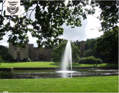
1. Towneley Hall:

Towneley Hall was the home of the catholic Towneley family for over 600 years, Now open to the public,the building contains Period rooms,A fine art and furniture collection, Exhibitions and events program in place throughout the year, Pre booked
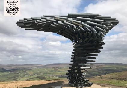
2. The Singing Ringing Tree:

On top of the moors is this amazing sculpture to see, easy to find and well worth a visit!!
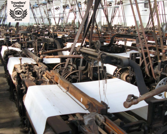
3. Queen Street Mill Textile Museum:

See the world's only working steam powered weaving mill bring the past to life. A rare chance to re-live the days when steam ran the world!
VI. History
Toponomy
The name Burnley is believed to have been derived from Brun Lea, meaning "meadow by the River Brun".Various other spellings have been used: Bronley (1241), Brunley (1251) and commonly Brumleye
Origins
Stone Age flint tools and weapons have been found on the moors around the town,[3] as have numerous tumuli, stone circles, and some hill forts (see: Castercliff, which dates from around 600 BC). Modern-day Back Lane, Sump Hall Lane and Noggarth Road broadly follow the route of a classic ridgeway running east–west to the north of the town, suggesting that the area was populated during pre-history and probably controlled by the Brigantes.
Limited coin finds indicate a Roman presence, but no evidence of a settlement has been found in the town. Gorple Road (running east from Worsthorne) appears to follow the route of a Roman road that may have crossed the present-day centre of town, on the way to the fort at Ribchester. It has been claimed that the nearby earthworks of Ring Stones Camp (53.793°N 2.174°W), Twist Castle (53.800°N 2.171°W) and Beadle Hill (53.803°N 2.169°W) are of Roman origin, but little supporting archaeological information has been published.
Following the Roman period, the area became part of the kingdom of Rheged, and then the kingdom of Northumbria. Local place names Padiham and Habergham show the influence of the Angles, suggesting that some had settled in the area by the early 7th century; some time later the land became part of the hundred of Blackburnshire.
There is no definitive record of a settlement until after the Norman conquest of England. In 1122 a charter granted the church of Burnley to the monks of Pontefract Abbey. In its early days, Burnley was a small farming community, gaining a corn mill in 1290, a market in 1294, and a fulling mill in 1296. At this point, it was within the manor of Ightenhill, one of five that made up the Honor of Clitheroe, then a far more significant settlement, and consisted of no more than 50 families. Little survives of early Burnley apart from the Market Cross, erected in 1295, which now stands in the grounds of the old grammar school.
Over the next three centuries, Burnley grew in size to about 1200 inhabitants by 1550, still centred around the church, St Peter's, in what is now known as "Top o' th' Town". Prosperous residents built larger houses, including Gawthorpe Hall in Padiham and Towneley Hall. In 1532, St Peter's Church was largely rebuilt. Burnley's grammar school was founded in 1559, and moved into its own schoolhouse next to the church in 1602. Burnley began to develop in this period into a small market town. It is known that weaving was established in the town by the middle of the 18th century, and in 1817 a new Market House was built. The town continued to be centred on St Peter's Church, until the market was moved to the bottom of what is today Manchester Road, at the end of the 19th century.
VII. Culture
Museums and galleries
On the outskirts of the town there are galleries in two stately homes, the Burnley council-owned Towneley Hall and Gawthorpe Hall in Padiham, which is owned by Lancashire County Council and managed by the National Trust. There are also two local museums: the Weavers' Triangle Trust operates the Visitor Centre and Museum of Local History in the historic surroundings of the Weavers' Triangle, while the Queen Street Mill Textile Museum is unique as the world's only surviving steam driven cotton weaving shed.
Mid Pennine Arts were instrumental in the Panopticons project and run exhibitions and creative learning projects across the town and wider area.
Parks
There are several large parks in the town, including Towneley Park, once the deer park for the 15th century Towneley Hall, and three winners of the Green Flag Award, Queens Park which hosts a summer season of brass band concerts each year, and Thompson Park which has a boating lake and miniature railway. The other parks include Scott Park, Ightenhill Park and Thursby Gardens. A greenway route linking Burnley Central Station along a former mineral line and incorporating the former Bank Hall colliery and reclaimed landfill site at Heasandford extends out of the town towards Worsthorne at Rowley Lake. The lake was constructed in the 1980s as a means to divert the river Brun away from former mine workings that were causing significant pollution of the river.
Festivals
Each year Burnley hosts the two-day Burnley International Rock and Blues Festival, which started as the Burnley National Blues Festival in 1988. The renamed festival moved from Easter to the early May Bank Holiday. The festival introduced a new logo, website and branding in a bid to attract new and younger audiences, and to encourage cross-town participation with a 'Little America' theme. It is one of the largest blues festivals in the country, drawing fans from all over Britain and beyond to venues spread across the town. In the 1970s the town was also an important venue for Northern soul and several local pubs still hold regular Northern soul nights. In recent years the town has also hosted the annual Burnley Balloon Festival in Towneley Park and a science festival at UCLan's local university campus. A funfair is usually held around the second weekend in July at Fulledge Recreation Ground, which is also the venue for the town's main Guy Fawkes Night celebration.
VIII. Other information
Burnley's sporting figures include England and Lancashire cricketer James Anderson, former England international footballers Jimmy Crabtree[150] and Billy Bannister, Premier League striker Jay Rodriguez, Northern Ireland and Sheffield United midfielder Oliver Norwood, former England and Everton Women's goalkeeper Rachel Brown, Pakistan and Tranmere Rovers midfielder Adnan Ahmed, ex-Manchester United player Chris Casper, Commonwealth Games Gold Medal-winning gymnast Craig Heap,Antipodean Supercars Championship driver for DJR Team Penske, Fabian Coulthard, also second cousin of Formula One driver David Coulthard, was born in Burnley along with Neil Hodgson, 2003 World Superbike champion. Also long-time Burnley FC chairman Bob Lord, football pioneer Jimmy Hogan (who grew up in the town), handball player Holly Lam-Moores[156] and hammer thrower Sophie Hitchon.]
IX. Contact information
Mayor/Officer: Wajid Khan
Tel: 01282 477106
Mail: democracy@burnley.gov.uk
Reference Website:
https://www.burnley.gov.uk/about-council/mayor
