Igoumenitsa, Thesprotia, Epirus 作者: 来源: 发布时间:2021-05-17
I. Population, Area
Total Area: 428.4 km2
Elevation: 10 m (30 ft)
Municipal unit density: 60/km2
Population: 25,814 (2011)

II.Natural Geography
The Patras, Greece to Brindisi, Italy car–ferry ships of the Hellenic Mediterranean Lines (HML) stop at Igoumenitsa, before crossing the Adriatic Sea and vice versa, as well as the ships of Superfast Ferries, ANEK Lines and several other shipping companies, before going to Ancona, Bari or Venice in Italy, and vice versa. Frequent passenger and car ferries to and from Corfu.
The Egnatia Odos motorway, which was opened in 2009 and is part of the Tabliczka E90.svg, has significantly enhanced the connection with Thessaloniki and Turkey and shortened the required travelling time from and to the Turkish border by several hours. Between Thessaloniki and the Turkish border, the road runs more or less parallel to the ancient Roman Via Egnatia.

III. ECONOMY
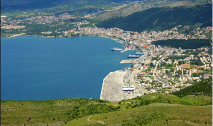
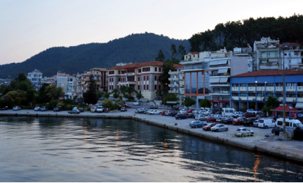
The city is built on easternmost end of the Gulf of Igoumenitsa in the Ionian Sea and primary aspects of the economy are maritime, transport, services, agriculture and tourism.
IV. Industrial Characterisitics
According to the draft strategy prepared by the relevant Ministry of Shipping (2012-2013) the port of Igoumenitsa becomes a "Connection Portal" not only of Greece with the rest of Europe, but of the whole of Europe with the Balkans, the Black Sea and the Middle East, through the development of combined transport (maritime-roads) directly and long-term (through the Egnatia railway), incorporating the railroad. In the beginning of 2012, the First Phase of the construction project of the New Port had been completed and progression to the Second Phase has begun in late 2013 and was completed by 2016, when the Third Phase of the constriction began. With the completion of the First phase, Igoumenitsa has become a modern, large port in the Mediterranean Sea, able to serve passenger, commercial and tourist traffic. The completion of the Second Phase, enabled the port to serve large cruise ships. Also, the planned creation of a freight centre in a section within the port area is estimated to greatly strengthen the commercial traffic and turn the city of Igoumenitsa into an international logistics centre.
V.Attractions
1.Bella Vraka Beach

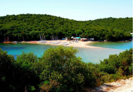
The Bella Vraka beach in Epirus, washed by the waters of the Ionian Sea, is a place full of splendor and summertime magic.
Many have described this beach as captivating and one that you should definitely visit. It is located on Mourtemeno Island but this is not considered a hindrance as one can cross the sea on foot.
It has a deep blue sea with pebbles and sand, and the lush greenery around you will definitely amaze you.
It is visited by thousands of people every year and is one of the most famous and beautiful beaches in Sivota.
The water reaches the knee while in the summer months the water level is just a bit lower. It must be noted that you will not find cafes or restaurants, so it would be best to have all the necessities with you.
It is an excellent destination of natural beauty that is definitely worth a visit for an incredible summer swim.
2.Mega Ammos Beach

Being the largest beach near Syvota, Mega Ammos somewhat justifies its name ("big sand") but in fact is 100 meters long and 30 meters wide.
References: www.feelgreece.com
VI. History
In ancient times, near Igoumenitsa, was the town of Gitanae (also known as Titana), and was one of the most important towns of the Kingdom of Thesprotis during the 4th century BC, covering 28 hectares. The circumference of its walls was 2,400 metres. The walls had four gates. Internal walls, in the shape of a sickle, divided the city in half. Its most noteworthy tower, located at the top of the hill, was round, and is thought to have been a religious sanctuary. Excavations have revealed a theatre which seats 2,500 and ruins of two temples.
Gitanae was a meeting place of the Epirote League (Livy 42.38.1). A spur near Philiates between the Kalamas River, the acropolis had a fine semicircular tower. A small theater, towers, and gateways which are still visible. The Kalamas may have been navigable to this point. The city was destroyed by the Romans in 167 BC and later on it was annexed into the Roman Empire. It was ruled by Ottoman Empire and was renamed as "Reşadiye" in 1909 honour of Mehmet V, Ottoman Sultan between 1909 and 1918. During Italo-Turkish War, Hamidiye torpedo boat was sunk by an Italian destroyer on December 30, 1912 in here.
After the liberation of the region from Ottoman rule during the Balkan wars in 1913, the city name was Grava, a name that stayed in use until 1938, when the town became head of the prefecture of Thesprotia and was then renamed to Igoumenitsa. The town was destroyed in 1944 during the Axis occupation of Greece and a new settlement grew up around the new ferry terminal in the 1950s and 1960s.
Following World War II, the Muslim Cham Albanian residents of Igoumenitsa were expelled to neighbouring Albania after large parts of them collaborated with the invading German forces.
VII.Contact Information
Mayor: Ioannis Lolos
Igoumenitsa Town Hall
Address: Souli 3, Igoumenitsa 46100
Phone: 2665361100
Fax: 2665026067
E- mail info@igoumenitsa.gr
Website: www.igoumenitsa.gr
