Kavala, Kavala, Eastern Macedonia and Thrace 作者: 来源: 发布时间:2021-03-02
I. Population, Area and Transportation
Total Area: 351.4km2
Elevation: 53m (174ft)
Municipal unit density: 200km2 520/sq mi
Population: 56,371 (2011)
Transportation: Kavala is linked by Air with Athens and charters from several major European cities. The ferry connects it with Thassos (hourly), Lesvos, Lemnos, and possibly Chios, Samos, Samothrace depending on which ferry companies are in business when you read this. There is a ferry to Kavala from Lavrion, a port one hour from Athens, that goes 3 times a week.
Highway Network
European route E90 runs through the city and connects Kavala with the other cities. The Egnatia Motorway (A2) lies north of the city. One can enter the city from one of two junctions: Kavala West and Kavala East. Kavala has regular connection with Interregional Bus Lines (KTEL) from and to Thessaloniki and Athens.
Airport
The Kavala International Airport "Alexander the Great" (27 km (17 mi) from Kavala) is connected with Athens by regularly scheduled flights and with many European cities by scheduled and charter flights.
Port
Kavala is connected with all the islands of the Northern Aegean Sea with frequent itineraries of various ferry lines.
Bus
The city is connected with all of the large Greek cities such as Thessaloniki and Athens. All of the local villages are also connected via bus lines. The cost of tickets is very cheap.
Rail
Kavala is not currently connected to the Greek rail network. However, plans exist to build a new Thessaloniki–Xanthi rail line via Kavala, as part of the Egnatia Railway corridor, at a cost of €1.25 billion. In 2019, Hellenic Railways Organisation awarded the contract to build the initial 31.8 km (19.8 mi) section between Xanthi and Kavala at a cost of €250 million.
II.Natural Geography (environment and resources)
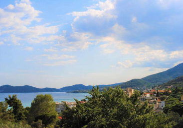
The Municipality of Kavala spreads in an area of approximately 350 square kilometers, at the north part of Greece, with a population of 70.000 within its administrative limits (population density 200/sq.km). Most of its people live in the city of Kavala (54.000). The average age of the population is 43 years while the average temperature in the area is just above 15° Celsius.
Main urban policy challenges are:
Sustainable urban development;
Sustainable tourism development;
Blue Growth;
Smart-city development;
Creative-city development.
Kavala’s procurement processes are very bureaucratic and decisions are made on the basis of the most economically advantageous tender.
III. ECONOMY
The municipality lies at the west part of the region of East Macedonia and Thrace with an economy based heavily on the service sector (77%) while the secondary (12,5%) and primary (10,5%) contribute less to the local GDP. Tourism, agriculture, fisheries and mining activities (petrol, marble). After the country's industrialization, Kavala also became a center of the tobacco industry in northern Greece. The building of the Municipal Tobacco Warehouse (1910) still stands today. Oil deposits were found outside the city in the 1970s and are currently exploited by two oil rigs (Prinos and Epsilon).
Resources: https://urbact.eu/kavala
IV. Industrial Characterisitics
The tobacco cultivation started in Kavala at the beginning of the 19th century forming an indispensible part of the city’s history for over 150 years, as well as the reason for the city to be wealthy and prosperous. From 1918 onwards operated in Kavala around 50 tobacco companies while the 160 tobacco warehouses engaged half of the country’s tobacco workers (around 14.000).
The Kavala Chamber of Commerce and Industry is a public law, legal entity that was originally founded in 1918, followed by the establishment of the Chamber of Trades and Crafts in 1923. The two Chambers merged in 1988. It has more than 11.000 members, including small and medium sized manufacturing industries, commercial enterprises, handicrafts companies, large industries, tourism enterprises, as well as professionals.
Resources: https://www.exporters-eoaen.gr/member-chambers/kavala-chamber-of-commerce?__cf_chl_jschl_tk__=b3e679abb1a17e23845328f5274c47b51591834e-1595606181-0-AUdjh0PKhr5r4P8TxwV3HpNde_1YM9aKZpwA1AJdyj_RfijRQ34FQFksoKOfxS9m6Yv_oq_972BcTfzl_PyzPMAll2R-gASCwFxa3By5cWuzbw6KAl35fyTVYLW2Pa8fkbopiexv8xH3KLjDc1lO6gvJl6AXhcIquEaxn3FGiFcJKDa39uKX6CVzZze0mHfIaMeoCKTmLeAeNfYaB9Jhv6S8jVD4KBRD62IBFHcTGvw8IDMe-gnFauS0b-CnsyIOO3dZsAvxu6Yj2x3omroyM3RKhNoRnckUr6XoJ3D-XMNWp2_IqD7Z50UaPTd78k2n45hxVfo-YJ1lMYSezTCc3IQ
V.Attractions
1. Panaigia
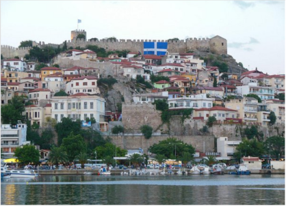
On the rocky cape and around its walls, Panaigia is ideal for journeys through time and history. Its roads are cobbled and most of the houses have wooden balconies, and fragrant gardens and courtyards. Starting at Karaoli Square, you can walk up Theodorou Poulidou St, pass the Imaret and courtyard of Mohammed Ali, and go as far as the church of Panagia, the Lighthouse and the Fortress, to enjoy a breath-taking view. Complete your route at Kamares, the old aqueduct, at the borders of the Old and New Town. The natural beauty of the region in combination with the picturesque tavernas, historic places, monuments and the modern neoclassical buildings, stimulate the senses and create wonderful images.
2. The Kamares
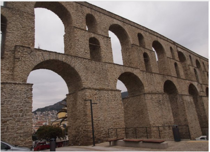
The Aqueduct of Kavala, popularly known as the Kamares, is a well-preserved aqueduct in the city of Kavala, Greece, and is one of the city's landmarks. While the aqueduct is of Roman origin, the present structure built by the Ottomans in the 16th century. A Byzantine barrier wall of the early 14th century, built as part of the fortifications on the Acropolis of Kavala, probably also functioned as an aqueduct. If so, it would have been a rare example of a Byzantine aqueduct, since Byzantine cities more typically used wells and cisterns rather than either maintaining existing Roman aqueducts or building new ones. The barrier wall was replaced with the present arched aqueduct during Suleiman the Magnificent's repair and improvement of the Byzantine fortifications. Some authors date that construction to the time of the 1522 Siege of Rhodes, but a more likely date is between 1530 and 1536. As late as 1911, it was still being used to supply the city with drinking water from Mount Pangaeus.
3. Philippi
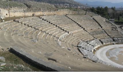
The history of the site of Philippi begins in 360/359 B.C. when the colonists from Thasos founded the first city, called Krenides. In 356 B.C. the city is endangered by the Thacians and it turns to king Philip II for support. Philip had already foreseen the economic and strategic importance of the city, so he conquered it, he fortified it and he renamed it after himself (Philippi). After the battle of Philippi, in 42 B.C., the city became a Roman colony and its importance was stressed by the fact that it was located on the Via Egnatia. The excavations on the site of Philippi began in 1914 by the French School of Archaeology at Athens. After the Second World War, excavations were resumed by the Greek Archaeological Service and the Archaeological Society. Nowadays, the archaeological exploitation of the site is carried out by the Archaeological Service, the Aristoteleian University of Thessaloniki and the French School of Archaeology at Athens. The finds from the excavations are housed in the Museum of Philippi. The most important archaeological site of eastern Macedonia, with characteristic monuments of the Hellenistic, Roman and Early Christian periods. Greece’s Philippi Inscribed on UNESCO’s World Heritage List
Resources: https://www.gtp.gr/TDirectoryDetails.asp?ID=15336
VI. History
The history of Kavala could stretch back 3000 years. Founded by settlers from Thassos, the new colony was called Neapolis or “New City”. Neapolis was also the port of Philippi where the Apostle Paul landed on his way to preach to the Macedonians. Kavala has been shaped by the Greeks, Romans, Ottomans, Pagans and Christians. Each having contributed to this city in a way that makes it what it is today.
In 1391 the city of Kavala was destroyed by the Turks. A fort called Christoupolos was still maintained. In the 15 century the name Kavala was given to the settlement and it grew under the reign of Suleiman the Great when the Kamares (aquaduct) was built. Today Kavala is a thriving seaport with a population of about 60 000. It is one of Macedonia’s largest cities and a center for the local tourism industry.
References: https://sithoniagreece.com/historical-kavala/
VII. Other Information
Kavala is a city in northern Greece, the principal seaport of eastern Macedonia and the capital of Kavala regional unit. Kavala is an important economic centre of Northern Greece, a center of commerce, tourism, fishing and oil-related activities, and formerly a thriving trade in tobacco.
Kavala hosts a wide array of cultural events, which mostly take place during the summer months. One of the top festivals is the Festival of Philippi[15] which lasts from July to September and includes theatrical performances and music concerts. Since 1957, it has been the city's most important cultural event and one of the most important of Greece.
Kavala was the main tobacco production and export center in the region as early as the Ottoman rule. Kavala is an important industrial town in northern Greece. Greece's largest fertilizer producer-the Greek Phosphate Fertilizer Company (PFI) is just east of the city. The company exports about 100,000 tons of compound fertilizers to China each year, with a total value of about 50 million U.S. dollars. It is the largest product exported by Greece to China, accounting for more than 50% of Greece's annual exports to China.
The Philippi Archaeological Site in Kavala, north-east of Greece, was recognized by UNESCO in 2016 as a World Heritage site.
