Alexandroupoli, Evros, East Macedonia and Thrace 作者: 来源: 发布时间:2021-02-24
1.Alexandroupoli, Evros, East Macedonia and Thrace
I. Population, Area and Transportation
Total Area: 1,217.0 km2 (469.9 sq mi)
Elevation: 11 m (36 ft)
Municipal unit density: 96/km2 (250/sq mi)
Population: 58,000 (2011)
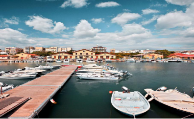
Alexandroupolis is accessible by all means, by air, by train, by road and by sea.Notable infrastructure projects are the modern-international port "Dimokritus", the Egnatia Motorway and the railway connection with major cities. Bicycle lanes also run in the city center. Alexandroupoli is served by Dimokritos International Airport (IATA:AXD) in the suburbs of Apalos, about 6 km from Alexandroupoli city centre.
There are daily flights to Athens, and also flights to Crete, while during the summer months some seasonal flights operate to/from Germany and Russia. The airport is connected to the city by highway, taxi services and scheduled bus services.
The port of Alexandroupolis has been used principally by travellers and there are daily services to the Island of Samothraki. Alexandroupoli has one railway station: Alexandroupoli or Alexandroupoli Port. It is served by trains to Thessaloniki and to Dikaia. There is an extensive network of train and bus replacements services throughout the region of Evros.
There were railway connections to Burgas in Bulgaria and to Edirne and Istanbul in Turkey, but those were suspended. The bus network has hourly buses to the major municipalities within Macedonia and Thrace offered from the Regional Coaches KTEL as well as daily services to Bulgaria and Turkey. OSE-Varan and Ulusoy have daily services to Istanbul and Athens each and depart from Alexandroupolis Railway Station in early mornings.
II.Natural Geography (environment and resources)
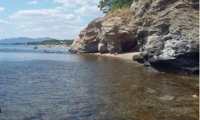
Alexandroupolis is a small town with a harbour and an airport. It is one of the newest cities in Greece as the modern city was founded in the middle of the 19th century featuring a sophisticated street plan.Though some guides describe it as "dusty", it has a rocky beach and a typical Greek nightlife. It is the last major Greek town before the Turkish border on the highway to Istanbul.
There's a significant Greek-American retiree bar scene, and the city's proximity to the Turkish border with legal prostitution and a much higher level of individual income, makes the nature of crime here entirely predictable. It's dirty and old and working class with a lot of free time and little regard for freedom or human dignity, but not particularly given to violent crime. This might be a very nice town in 10 years following any generation gap.
III. ECONOMY
With its strategic position, at crossroads of sea and land routes, Alexandroupolis connects Europe and Asia and is the first Greek city to be encountered when crossing the Turkish and the Bulgarian borders.
Alexandroupolis is considered to be one of the most important national transportation hubs as it is accessible by all means of transport. The city’s notable infrastructure consists of its modern international port which current authorities try to improve in order to accept bigger volumes of commercial and tourist ships, the Egnatia Odos Highway, and the railway that links Alexandroupolis to all other major Greek cities to the west. All of the above turn the city into a commercial hub and create the right conditions for further development in the future.
Daily bus routes connect Alexandroupolis with the cities of Komotini, Xanthi, Kavala, Thessaloniki, Athens, and other areas within the prefecture of Evros. In addition, rail routes connect the city with Thessaloniki, passing from Komotini, Xanthi, Drama, Serres, and Kilkis. There is also an international airport located seven kilometers from the city center which handles daily flights to and from Athens and weekly flights to and from Crete and Lesvos. During the summer there have been efforts to add seasonal flights to and from Germany and Russia. The harbor is mainly used for commercial purposespassenger traffic is limited to some connections with the islands of the northern Aegean and the island of Samothrace just south of the city.
IV. Industrial Characterisitics
With its strategic position, at crossroads of sea and land routes, Alexandroupolis connects Europe and Asia and is the first Greek city to be encountered when crossing the Turkish and the Bulgarian borders. The city’s notable infrastructure consists of its modern international port which current authorities try to improve in order to accept bigger volumes of commercial and tourist ships, the Egnatia Odos Highway, and the railway that links Alexandroupolis to all other major Greek cities to the west. All of the above turn the city into a commercial hub and create the right conditions for further development in the future.
The city also boasts a strong trading activity with shops and businesses that cover all sectors of the production chain. It has well-developed transport and logistics sector due to its strategic position and the existence of many relevant infrastructures. In particular, the port of Alexandroupolis is among the busiest in northern Greece and the planned connection to the railway line in the near future creates even more prospects for the city. Some of the most important industrial enterprises of Alexandroupolis region are the "Flourmills Thrakis", "Yfantis" (food industry), and "Akritas" (wood processing industry).
Reference Website: https://www.hvs.com/article/7867-in-focus-alexandroupolis-greece
V.Attractions
1.Ottoman Bath,Traianoupolis
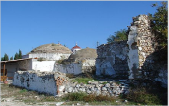
Traianoupolis The city was founded by the Roman Emperor Trajan (reigned 98-117) and was famous in Roman times for its baths. In the 4th century, it became the capital and metropolis of the Thracian Roman province of Rhodope. Despite a chequered history, the city remained the metropolis of the ecclesiastical province of Rhodope until its decline in the 14th century. The area was destroyed in 1322 by Bulgarian raids and 1329/30 by Turkish troops. On display are ruins of former bathing facilities and parts of the city wall.
2.Mesembria
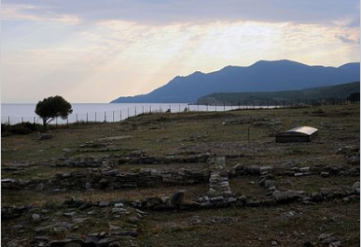
Mesimvria was a colony of the inhabitants of the island of Samothrace, built at the end of the 7th century BC. The city flourished in the 5th and 4th century BC. However, during the period of the Macedonian and later Roman rule began to gain importance, as the construction of roads in the hinterland lowered the importance of the coastal city. On the excavation site, the remains of the fortress wall with towers, private houses, a road network, public buildings, a sanctuary of Demeter and an Apollo temple were found. The most important monuments of the excavation site are: The Shrine of Demeter. Inside the building, silver, gold, silver and gilded relief panels were found, all connected to the Demeter cult. Dated to the 4th century BC. The archaic temple of Apollo. It was part of a larger building complex (35 x 45 m) with a central paved courtyard, surrounded by a stoa. Many ceramic fragments with engraved inscriptions were inside the temple from the 6th and 5th centuries BC. Found.
3.Castle of Avanta
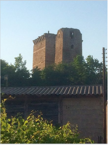
Castle of Avanta (Potamos) (Boz-Tepe) (outside the village of Avanta, 10 km from Alexandroupolis). The castle is on the provincial road that connects Alexandroupolis with Avanta. From far you can see the three impressive medieval towers of the Potos River. They are square and surrounded by a double wall. It is thought to have been built in the 13th century by the Gatelouzos, the Genoese conquerors of the area, on a site occupied on prehistoric, Ancient Greek and Byzantine periods. The climb to Avanta (or Potamos) Castle, from the west side of the hill, takes about 20 minutes. A grandiose gate is preserved, with two tall towers on both sides and the ramparts of the castle, with the stairs leading up there. The view of the whole plain from the warriors fully justified the construction of the Avanta Castle at this point. The ruins that the visitor sees today date back to the 13th century, although there are findings from the Mycenaean period. The whole area has scattered castles on hillsides and rocks that allow the field and the passage to be monitored by Rodopi and Komotin.
4.The Lighthouse of Alexandroupoli
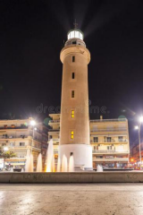
Attraction and symbol of the city is the Lighthouse (recognized as a cultural heritage monument in 2013) located on the city's coast road, Alexander the Great. It was built in 1850 and started operating in 1880, built on the western side of the city's harbor to facilitate the coasting of local sailors who traveled to the area of Hellespont. It is on a cylindrical pedestal and is 27 meters from the average sea level and 18 meters from the ground, making it one of the tallest lighthouses in Greece. It operates with electricity and its distinctive feature is its light beam reaching 24 nautical miles (approximately 44 km) and three white blinks every 15 seconds.
VI. History
From Neolithic Period to the 19th Century
In the Byzantine Period, Alexandroupolis played a leading role, because the city bordered with Constantinople and for this reason was guarded by powerful military installations. In the following years, however, up to the 19th century, the city seems to be deserted and covered by forests and wild trees. The city was first settled in the 19th century, under the Ottoman Empire. Long used as a landing ground for fishermen from the coast of Samothrace opposite, a hamlet developed in the area during the construction of a railway line connecting Constantinople to the major cities of Macedonia from Kuleliburgaz. The work was part of an effort to modernise the Empire, and was assigned to engineers from Austria-Hungary. The settlement soon grew into a fishing village, Dedeağaç. In 1873, it was made the chief town of a kaza, to which it gave its name, and a kaymakam was appointed to it. In 1884, it was promoted to a sanjak, and the governor became a mutasarrıf. In 1889, the Greek archbishopric of Aenus was transferred to Dedeağaç. In the late 19th and early 20th century, Dedeağaç was part of the Adrianople Vilayet.
Russo-Turkish War
Dedeağaç was captured by the Russians during the Russo-Turkish War (1877–1878), and Russian forces settled in the village. The officers in charge saw that reconstruction incorporated wide streets running parallel to each other, allowing the quick advance of troops, and avoided cul-de-sacs. This was very unlike the narrow alleys, cobbled streets, and dead-ends that were characteristic of Ottoman cities at the time. The city returned to Ottoman control by the end of the war, but the brief Russian presence had a lasting effect on the design of Alexandroupoli's streets.
Balkan Wars
The building of a railway station in Dedeağaç led to the development of the village into a town, and a minor trade centre by the end of the century. The town became the seat of a pasha as the capital of a sanjak. Ottoman control of the town lasted until the Balkan Wars. On 8 November 1912, Dedeağaç and its station was captured by Bulgarian forces with the assistance of the Hellenic Navy. Bulgaria and Greece were allies during the First Balkan War, but opponents in the Second Balkan War. Dedeağaç was captured by Greek forces on 11 July 1913. The Treaty of Bucharest (10 August 1913) however, determined that Dedeağaç would be returned to Bulgaria along with the rest of Western Thrace. In September 1913, after the end of the Second Balkan War, about 12,000 Bulgarian refugees took refuge in the outskirts of the city. They were from 17 different villages all over the Western Thrace fleeing ethnic cleansing.
World War I
The defeat of Bulgaria by the Allies in World War I (1914–1918) ensured another change of hands for the town. Western Thrace was withdrawn from Bulgaria under the terms of the 1919 Treaty of Neuilly. Alexandroupoli was under temporary management of the Entente led by French General Charpy. In the second half of April 1920 in San Remo conference of the prime ministers of the main allies of the Entente powers (except United States) Western Thrace was given to Greece. However, Bulgaria retained the right of transit to use the port of Dedeagach to transport goods through the Aegean Sea. The change of guard between French and Greek officials occurred on May 14, 1920, in the city's Post Office. In the interior of the Post Office there is a memorial plaque concerning this event. The city was soon visited by Alexander of Greece. He was the first King of Greece to visit the town which was renamed in his honour.
Greco-Turkish War
Following the defeat of Greece in the Greco-Turkish War (1919–1922), the Greek Army under General Theodoros Pangalos retreated from Eastern Thrace to the area of Alexandroupoli. Bulgaria used the opportunity of the Greek defeat to demand that Alexandroupoli either be returned to its control or declared a neutral zone under international control. Both demands were soundly rejected by the Greek leadership and found no support in the League of Nations. The Treaty of Lausanne (24 July 1923) affirmed that Western Thrace and Alexandroupoli would continue to be controlled by Greece.
World War II
During World War II (see Axis occupation of Greece), the Nazis gave Alexandroupoli to their Bulgarian partners. Alexandroupoli was subsequently under Bulgarian occupation between May 1941 and 1944. The city suffered some damage to buildings and loss of population during the war, but was largely spared the effects of the Greek Civil War (1946–1949). Forces of the communist Democratic Army of Greece in and around the town area were small and loosely organized, resulting in the absence of major battles in the area; the return of peace allowed for Alexandroupoli to grow from a town of 16,332 residents in 1951 to a city of 57,812 residents by 2011.
VII. Other Information
Near the town there's an archaeological site of ancient Priniatikos Pyrgos. It appears to have been first settled in the Final Neolithic era, circa 3000 BC. Activity on the site continued throughout the Minoan Bronze Age and the Classical Greek and Roman periods, spanning a total of up to 4,000 years. Since 2007, Priniatikos Pyrgos has been undergoing excavation by an international team under the auspices of the Irish Institute of Hellenic Studies at Athens.
VIII.Contact Information
Mayor: Antonis Zervos
MunicipalityWebsite:www.alexpolis.gr
Alexandroupolis Municipality: 306 Republic Avenue
T.K. 68132 - Alexandroupolis - Greece
Tel: (+30) 25510 64100
Fax: (+30) 25510 64142
