Sandnes,Norway 作者: 来源: 发布时间:2021-02-19
一、所属省或是州,具体位置,人口,面积
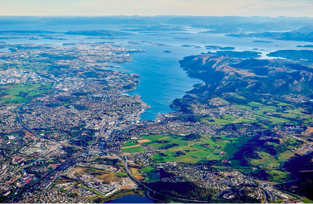
Sandnes is a municipality in Rogaland county, Norway. It lies immediately south of the city of Stavanger, the 4th largest city in Norway and together, the Stavanger / Sandnes area is the 3rd largest urban area in Norway. The urban city of Sandnes lies in the extreme western part of the vast municipality and it makes up about 5% of the total land area of the municipality.

Sandnes is part of the district of North-Jæren. The western part of the municipality is very urbanized while the eastern part of the municipality is very rural. The administrative center of the municipality is the city of Sandnes. The city is divided into 13 boroughs and the administrative center is located in the borough of Trones og Sentrum in the city center. There are several village areas in the rural parts of the municipality including Hommersåk, Høle, Foss-Eikeland, Stokka, Forsand, Lysebotn, and Vatne.
The 1,041-square-kilometer (402 sq mi) municipality is the 109th largest by area out of the 356 municipalities in Norway. Sandnes is the 11th most populous municipality in Norway with a population of 79,537. The municipality's population density is 84.3 inhabitants per square kilometer (218 / sq mi) and its population has increased by 20.8% over the previous 10-year period.
二、自然地理
1.地理条件
The municipality lies in the Jæren region and stretches 90 kilometers (56 mi) nearly from the west coast of Norway to the rugged mountainous interior. The city of Sandnes is located at the base of the Stavanger Peninsula, about 15 kilometers (9.3 mi) south of the city of Stavanger, and these two cities have expanded so as to form a conurbation. The municipality of Sola is located to the west, Klepp and Time, Gjesdal to the south, Sirdal and Bykle to the east, Strand and Hjelmeland to the northeast, and Stavanger to the northwest. The fjord Gandsfjorden is situated north – south at the west end of the municipality and the Høgsfjorden and Lysefjorden dominate the eastern part of the municipality. The international airport for Sandnes / Stavanger is situated in Sola, just to the west of Sandnes.
Prior to 2020 (when the municipality was enlarged), the city-municipality of Sandnes was divided into 13 boroughs: Austrått, Figgjo, Ganddal, Hana, Høle, Lura, Malmheim og Soma, Riska, Sandved, Stangeland, Sviland, and Trones og Downtown.
The landscape of western Sandnes is quite flat. On the long west coast there are several beaches and further inland the land is raised to form low plains with some small peaks rising up to 400 to 500 meters (1,300 to 1,600 ft) above sea level. From Stavanger and Sandnes it is approximately one hour by car to alpine and skiing resorts. In Sandnes there are some easily accessible small mountain peaks, such as Dalsnuten and Lifjell, with a view over the Sandnes / Stavanger area. The renowned Lysefjorden is also easily accessible by car or boat. The lake Frøylandsvatnet, the river Figgjoelva, and the mountain Hanafjellet are all located in Sandnes.
The Lysefjord in the eastern part of the municipality is surrounded by very steep 1,000-meter (3,300 ft) tall cliffs such as Kjerag and Preikestolen, with the Lysefjord Bridge crossing the fjord near the western end. The famous Kjeragbolten boulder and Kjeragfossen waterfall are located along the inner part of the fjord. The village of Lysebotn lies at the eastern end of the fjord. The lake Nilsebuvatnet is located high up in the mountains, north of Lysebotn on the border of Strand and Forsand municipalities. It is regulated for hydroelectric power use at the Lysebotn Hydroelectric Power Station.
2. 交通情况
Sandnes is centrally located in the junction between Nord-Jæren, Jæren and Høg-Jæren, in addition to the fjord which provides good access to the sea. Business travel has a large car share and this combined with the central location and undersized road network creates inefficient transport flow. In addition to the railway and bus services, plans are being made for urban railways on existing railway tracks and on tracks in existing and new public transport routes in Stavanger / Sandnes. Both municipalities have ambitions for a lower car share and have also started planning for a "bicycle motorway" between the cities.
Stavanger Airport, Sola is located approximately 12 km from Sandnes city center. Buses and hotel expresses operate routes between the airport, central hotels and the city. The now closed Forus airport was partly in the municipality.
The railway runs right through the city and its center on the embankment and viaduct. The station Sandnes center is located in the middle of the city and at the bus station, the hub for bus traffic. Stations that only have local traffic are Ganddal station at Ganddal, and Sandnes stop south of the city center. The latter is the old main station and is located by the Brueland freight terminal, which was previously the city's freight terminal. Today's freight terminal is located at Ganddal. In November 2009, the double track to Stavanger was completed and this has resulted in more frequent departures (every 15 minutes) with local trains between the two cities, but no shorter travel time.
City buses from Columbus ply the city center and districts as well as the entire urban area of Stavanger / Sandnes. There are also routes south to Ålgård and Jæren. Express buses go to Bergen, Egersund and Kristiansand and ski buses to Sirdals.
三、经济发展和规模
Sandnes hosts a large array of retail shops of most kinds and is used by the neighboring municipalities appreciating the service and wide range of selections. Sandnes is known as Norway's bicycle city, mainly due to the fact that the bicycle manufacturer Øglænd DBS was situated here for decades. The city offers a variety of routes for everyday riders and tourists. Since 1996, a public bicycle rental program has been in operation in the city.
The city has a vibrant industrial base, mainly in the Ganddal area in the south and the Lura and Forus area in the north along the municipal boundary with Stavanger. There is significant activity related to oil exploration in the North Sea and also some IT related companies. In this suburban region between Sandnes and Stavanger, malls and department stores have also been established. Among these malls is one of Norway's biggest malls, Kvadrat meaning "square" (although it is not square shaped anymore as it has expanded several times since it opened in 1984).
Around 30% of the population is employed in Stavanger (Q4 2004). Sandnes was formerly known as the pottery town of Norway - due to the important ceramics industry based on the extensive occurrence of clay in the surroundings. The Vatneleiren military base is also located in Sandnes, just outside Vatne.
In 1896, a quay was built further inland in Vågen, by today's Havnegata and the railway. The quays remained divided and without the ability to accommodate large ships until 1927, when the municipality expropriated nine properties and built three larger quays of stone and wood. These were built up with railway tracks and swing cranes. In the 1950s, the development accelerated and in 1960, the filling in of the beach areas from Jernbanekaien to the wave bottom in the inner part of the city began. Together with an expansion in 1974, this created a continuous quay from the first at Nordre Sjøalmenning to Indre Vågen, which could then be used for the oil industry. Throughout the 1970s and 1980s, the harbor was continuously expanded with cranes, buildings and warehouses.
四、产业特点重点项目
Shipping in Sandnes started around 1800 and involved the first half century mostly herring fishing. In 1875, Sandnes received its first port commission and the port district was established. The boundary went by "a straight line drawn from the northernmost boundary of the charging station at Somanæsset over the fjord to the northernmost edge of Kostøet by Laberget on the east side of the fjord". In 1878, the city got its first sea common and this was expanded until 1890, when the first municipal quay opened. In 1894, the port commission was transformed into a port board. Before the turn of the century, sailing ship activity peaked with dozens of ships, and steamship companies began to take over. Routing companies with passenger traffic, mainly to Bergen, were established.
Towards the end of the 1980s, a guest harbor was built for small boats in the innermost part of Vågen, at the same time as Norestraen and Luravika were expanded into a public harbor, of which the northern part is a small boat harbor. In recent decades, the port has been constantly growing, and repeated attempts at a single inter-municipal port for Nord-Jæren have failed. As of 2007, the harbor is in the process of moving all activity out of the city center and to the harbor on Norestraen to save the city center for industry and traffic, and limited sailing height in the Inner Harbor at a future Gandsfjord bridge. The areas will be converted into open space, office, residential and public buildings as well as a sea promenade along the entire Vågen.
Sandnes at night. The picture shows the E39 on the way to the city.
Europavei 39 runs through the city as a motorway and motorway, north to Stavanger and south to Gjesdal. Highway 44 runs west of the city as a four-lane exit-free country road and motorway, and through the business area Lura as a city street north to Stavanger. To the south of the built-up area by Skjæveland is the two-lane country road to Klepp. Highway 505 goes from rv. 44 at Lura, south through the city center to Ganddal, where it turns southeast towards Orstad in Klepp. Highway 509 runs from the center of Sandnes via Sola Airport to Stavanger. Highway 13 leaves the E39 at Hove and is exit-free with level crossings out of the built-up area where it continues to the ferry quay in Lauvik by Høle by ferry on the Høgsfjord connection to Forsand and Ryfylke. The main route from Hana to Høle follows county road 316 and national road 508 as national road 13 is very narrow over several sections.
The road network in Sandnes is heavily congested during periods of the day and among decisions and plans to alleviate the problems are various plans and decisions, such as bicycle investment, development of public transport routes, and expansion and development of double ring road network.
From the beginning, the town has been known for good shopping opportunities, and grew as a port and trading place for Jæren. Due to difficult road conditions between Jæren and Stavanger, despite the lack of privileges, it was increasingly chosen to conduct trade and transport from Sandnes from the 17th and 18th centuries. Large clay deposits meant that the brickwork industry grew from the end of the 18th century and laid the foundation for the town's growth through the 19th century. Towards the end of the 19th century, significant wool, timber and mill industries and steamship shipping companies were established, and in the first half of the 20th century bicycle production and canning. Further through the 20th century, the industry grew and several Sandnes companies became among the leaders in their industries, e.g. Sandnes Wool Factory (wool product), Figgjo Faience (ceramics), Øglænd (bicycles) and business environments within wood products / prefabricated houses and oat mills. From 1950 until the amalgamation of municipalities in 1965, there was temporarily no population growth in Sandnes municipality. The population was around 4,000 during this period.
With the amalgamation of municipalities with Høyland, Høle and Hetland in 1965, the city got large agricultural and not least new industrial areas within its borders. From the 1970s, petroleum activity in the North Sea has had an ever-increasing influence on the city's economy, with its demand for mechanical industry, port services and administrative and financial services. Another trend that started the same decade was that the traditional industry closed down or moved out of the city center, and shopping malls were established in the factory buildings. New industrial areas were established at Kvål, Foss-Eikeland, Lura and Stokka. In and near the city center, Sandnes experienced a wave of new shopping centers in the 1980s, which helped to support the city's function and reputation as an important trade and service center on Jæren. Sandnes is especially known for one of Norway's longest pedestrian streets, Langgata, and what was for a long time Norway's largest shopping center, Kvadrat.
In the 2000s, the most important business areas are retail trade, hotels and restaurants, business services and real estate, construction, industry and mining (especially the engineering industry) and public administration and services. The companies with the highest turnover in 2007 and business address in Sandnes were Esso Norway (50.3 billion), Eni Norway (17.6 billion), Sandnes Sparebank (2.2 billion), Gaz de France Norway (1.7 billion .) and BIS Industrier (1.5 billion). Among other important companies is Equinor, which does not have a business address in Sandnes. Several of Equinor's office premises are located in Sandnes and the company is an important employer for the inhabitants of Sandnes.
五、风景名胜,景点( attractions)
1. Sandnes Church

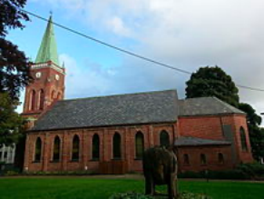
Sandnes Church (Norwegian: Sandnes kirke) is a parish church of the Church of Norway in the large Sandnes Municipality in Rogaland county, Norway. It is located in the borough of Trones og Sentrum in the center of the city of Sandnes in the far western part of the municipality. It is the church for the Sandnes parish and it is the seat of the Sandnes prosti (deanery) in the Diocese of Stavanger. The red, brick church was built in a long church design in 1882 using plans drawn up by the architect Hartvig Sverdrup Eckhoff. The neo-gothic church seats about 420 people.
The city of Sandnes was established as a ladested in 1860 and at the same time it was separated from the large municipality of Høyland. The city was without a church of its own for its first 22 years in existence. During that time, residents of Sandnes municipality (and parish) had to go to the nearby Høyland Church, located in outside of the city (and in a different parish). It was not until 1880 when the parish began to raise funds and construct the new church. The new church was completed in 1882. When the church was renovated in 1962-1963, the nave and choir were extended in order to enlarge the church.
2. Sandnes sports park

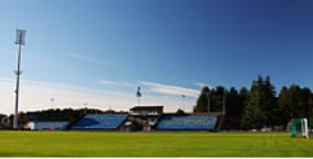
Sandnes sports park is located on Trones in Sandnes in Rogaland. Sandnes sports park is owned by Sandnes municipality and is used by Sandnes Ulf (football) and Sandnes Idrettslag (athletics). The park consists of Sandnes stadium for athletics and football, Giskehallen sports and swimming hall, tennis facilities, artificial turf courts, training courts with grass, floodlit courts with gravel, skateboard area, as well as various hiking trails and jogging paths.
3. Vitenfabrikken

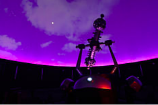
Vitenfabrikken is a museum and science center in Sandnes and the largest department at Jærmuseet. Vitenfabrikken, formerly Sandnes Museum, opened in 2008. There are three floors with an interactive exhibition as well as a planetarium, a Tesla coil, an audience workshop and Makerspace Vitenfabrikken.
Vitenfabrikken documents as a museum regional technology and industrial history and Sandnes' urban history. In 2019, a new exhibition about Øglend opened, as well as a new mathematics exhibition at Abelloftet.
六、历史文化
1.历史
The small port village of Sandnes was granted ladested (small seaport city) status in 1860. On 6 April 1861, the small city was separated from the municipality of Høyland to form a separate self-governing municipality of its own. Initially, the municipality had 440 residents. On 1 July 1957, a small part of Høyland municipality (population: 18) was transferred to the city of Sandnes.
During the 1960s, there were many municipal mergers across Norway due to the work of the Schei Committee. On 1 January 1965, the city of Sandnes (population: 3,961) was merged with the municipality of Høyland (population: 20,353) and parts of the municipalities of Høle (population: 926) and Hetland (population: 2,077).
During 2014 the Storting decided that the number of municipalities in Norway has to be lowered. If the municipalities of Sandnes, Stavanger and Sola merge, a new municipality would be formed called Nord-Jæren, after the name of the geographical location the munincipalities are located on. After the city council said no to merging, proposals for Forsand merging with Sandnes were enacted instead. On 1 January 2017, a small 350-decare (86-acre) area on the southwestern edge of the village of Solakrossen was transferred from Sandnes municipality to the neighboring municipality of Sola. On 1 January 2020, most of the neighboring municipality of Forsand was merged with Sandnes to form one large municipality called Sandnes.
The municipality (and city) is named after an old "Sandnæs" farm, since the city was built on its grounds. The first element is sand which means "sand" or "sandy beach" and the last element is nes which means "headland". The farm was located at the end of the Gandsfjorden where the city center is located today.
2. 文化体育
Since 2016, the primary football team, Sandnes Ulf, has played in the second tier, 1. divisjon, of Norwegian professional football.
The major tourist attraction in Sandnes is the Science Factory (Vitenfabrikken). It is a 4,000-square-meter (43,000 sq ft) science museum with science and art exhibitions, a planetarium, sun telescopes, and chemistry shows.
Sandnes is the only city in Norway which is a member of the World Health Organization's network of Healthy Cities. Sandnes and Stavanger were chosen along with Liverpool, United Kingdom, to be a European Capital of Culture for 2008.
Higher education facilities include Forus Upper Secondary School, Sandnes Upper Secondary School, Gand Upper Secondary School, Akademiet Upper Secondary School and Lundehaugen Upper Secondary School. In 2010 Forus and Lundehaugen were no longer upper secondary schools; Lundehaugen is now a high school. Most of Forus and Lundehaugen merged into a new school named Vågen.
Sandnes is also known for its Rugby League team, Sandnes Raiders which has supplied the Norwegian national team with players.
七、其他信息
The coat of arms was granted on 21 April 1972. The arms show a white piece of pottery on a green background. Pottery was chosen since it was one of the main industries in the late 18th century. The symbol is a leirgauk, which in English would be a ceramic cuckoo-bird (leir (e) = clay / ceramic and gauk / gjøk = cuckoo-bird). The ceramic Sandnes-cuckoo (Norwegian: sandnesgauker) is an ocarina or simple flute which was made by the potteries in Sandnes and used to advertise their products. Later it also became a nickname for people from Sandnes.
八、联系方式
Town manager: Stanley Wirak
Phone:51 72 72 72
Email:rogaland@nrk.no
