Eigersund, Norway 作者: 来源: 发布时间:2021-02-19
一、所属省或是州,具体位置,人口,面积
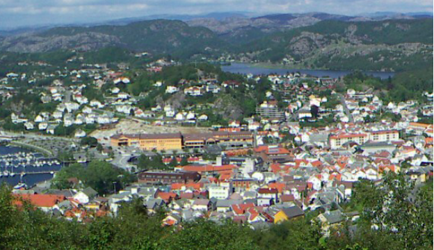
Eigersund is a municipality in Rogaland county, Norway. It is in the traditional district of Dalane. The administrative center of the municipality is the town of Egersund. The town was known for its pottery factory (closed in 1979) and it is among Norway's biggest fishing ports. The villages of Helleland, Hellvik, and Hestnes are also in Eigersund. The island of Eigerøya lies just off shore from Egersund. The island has several well-known businesses and attractions including the Eigerøy war memorial from World War II. The 432-square-kilometer (167 sq mi) municipality is the 228th largest by area out of the 356 municipalities in Norway. Eigersund is the 82nd most populous municipality in Norway with a population of 14,811. The municipality's population density is 38.2 inhabitants per square kilometer (99 / sq mi) and its population has increased by 4.5% over the previous 10-year period.
二、自然地理
1.地理条件
Eigersund extends from the North Sea coast to the border of Agder county. It borders the municipalities of Hå and Bjerkreim to the north and Sokndal to the south. The municipality is centered on the town of Egersund, and includes the island of Eigerøya. The landscape includes many rivers and lakes, as well as woods and several barren rocky and heather-clad moors. The lakes Grøsfjellvatnet, Eiavatnet, Nodlandsvatnet, and Teksevatnet lie in the municipality.
Eigerøya is an island off the coast of Egersund. The island is connected to the mainland over Eigerøy bridge, which was completed in 1951. The island's coastline is characterized by a number of small bays, as well as Lundarviga. Eigerøya is divided almost into two of the large bay of Lundarviga. The island is surrounded by a number of small islets. Eigerøy Lighthouse and Vibberodden Lighthouse are both located along the shores of Eigerøya.
Map of the geology of Dalane and Lista. Rogaland anorthosite province, formerly known as the Egersund field, is a 920-932 million year old formation of deep rocks, which originates from 1-8 km deep. It contains valuable minerals such as ilmenite and apatite. The whole of southeastern Rogaland within Dalane belongs to the 1,700 km² Rogaland anorthosite province, formerly known as the «Egersund field». This is a magmatite formation of deep rocks that also continues out into the North Sea in a similarly large area. The most common rocks are the light solidification rocks anorthosite, the gabbro types norite and jotunite, further the economically interesting apatite, magnetite and ilmenite, as well as the deep rock mangerite. The apatite fields are rich in phosphorus and are felt on an extra lush vegetation. Towards the end of the formation of the Sveconorvegian bedrock shield 932 million years ago, masses rose from the mantle up to a depth of up to 8 km. The older, Sveconorvegian gneiss and granite fields around the anorthosite formation were melted down and transformed under strong heat to, among other things, osumilite in a 15-30 kilometer wide zone.
2. 交通情况
European route E39 runs through the municipality, passing the village of Helleland. The Sørlandet Line runs through the municipality, stopping at Egersund Station and Hellvik Station. oad connection east to Vest-Agder via E39 which also continues north in Rogaland. Highway 44 goes north through Jæren to Sandnes and Stavanger, and south through Sokndal and Jøssingfjord to Flekkefjord.
Egersund is only an hour's drive from Sola Airport. Western Norway's first railway, the train connection between Egersund and Stavanger (Jærbanen) opened on 27 February 1878 with two stations in Eigersund: Egersund station (local and long-distance traffic) and Hellvik station (local traffic only). Egersund had a ferry connection to Hanstholm in Denmark, which was operated by Fjord Line. This was moved to Stavanger in October 2008. Prior to this, there was a ferry connection with Hirtshals in Denmark, which was operated by Fred-Olsen Line (current Color Line).
三、经济发展和规模
Egersund is known for faience and fishing. The faience factory was closed down in 1979, but Egersund is still big in fishing and herring oil. The first industries in the municipality were related to the sea, agriculture and animal husbandry. In Viking times, trade was important to the municipality. Fishing has always been very important to the municipality. The existence of the entire coastal population was for a long time very dependent on fishing. Of greatest importance was spring herring fishing, but herring has been capricious. The herring disappeared in periods completely from the spawning grounds and created downturns for the municipality. Egersund is now one of Norway's largest fishing ports, measured in landed quantities.
Egersund's business life, which is not directly related to fishing, is nevertheless largely related to the sea and boats. The maritime industrial environment includes locally run internationally known companies such as Simrad (manufacturer of autopilots and the like, formerly known as Robertson), Jeppesen Marine (formerly C-Map, manufacturer of electronic charts), Egersund Trawl and a number of other trawl workshops, herring oil factories and the like. Companies outside have also established themselves here, e.g. Aker solutions. Due to the climate and soil in Eigersund, almost no grain is grown. Sheep farming and milk production are important, while some fruit and berries are grown. Total agricultural area in operation today is 47 km².
四、产业特点重点项目
An updated overview of our ongoing construction projects. See also the pages for zoning plans, plans and municipal plan.
Rundevoll kindergarten, New Rundevoll kindergarten, November 6, 2020. Existing kindergarten with two departments will be demolished and replaced with a new kindergarten with six departments. A new kindergarten will also replace the kindergarten on Husabø.
Gamleveien closed, Remediation of water and sewers in Gamleveien, November 1, 2020. Water and sewage will start on May 25 with remediation of old water and sewage pipes in Gamleveien. The work is expected to continue until the autumn and started at the intersection between Gamleveien and Langaards gate.
Espelandshallen Lagård, New swimming pool at Lagård, October 1, 2020. A new swimming pool will be built at Lagård.
Revsvatnet, Transmission line for water, 11 September 2020. A new transmission line will be installed between Revsvatnet and Hobdalsbukta in Slettebøvatnet. This must be seen in connection with a new waterworks at Kjerketjørna in Vannbassengan
Waterworks are being built, New waterworks in Vannbassengan, 11 September 2020. Eigersund municipality will build a new waterworks to secure its water supply. This will be located by Kjerketjørna in Vannbassengan.
New Eigerøy school, June 18, 2020. The purpose of the plans is to facilitate the construction of a new primary school on Eigerøy with associated functions. Most of the old school located on the same plot is to be demolished. New school must be located where existing school is today
New operating base at Tengs, June 15, 2020. The desire is to have a rational base for the technical operating units that ensure good and efficient services for the municipality's residents in functional work premises. The result goal for the main project is to establish an operating base for the operating units Road and Outdoor Environment, Construction and Real Estate and Water and Sewerage.
Sketches of Hellvik kindergarten, Hellvik kindergarten, June 15, 2020. A possible expansion of Hellvik kindergarten must be seen in connection with expected population growth, and principles for being allocated a kindergarten place in a geographically delimited local community.
Lysgården on Bakkebø, Activity center for the mentally handicapped, 15 June 2020. Deviations have been detected here, so users will be moved to temporary premises.
Hestnes gravlund, 11 June 2020. A new Hestnes cemetery will be built and this will also connect the residential area in Hestnes and Hoveræget.
Eigersund fire and rescue, New fire station, May 18, 2020. After an open and verifiable process, Langholmen is considered to be by far the best professional and financial choice for the location of a new fire station.
Hestnes residential area stage 2, April 27, 2020. Hestnes residential area will be expanded in several stages. The first stage was completed in 2015, and consists of the Brekkå collection road, as well as access roads around the collection road. Detached plots and residential areas are for sale.
Glass wall, Flood protection in the center, April 24, 2020. The «Theme plan for flood protection measures in Eieåna and Lundeåna» has been adopted. The plan includes larger and smaller measures that will help secure these two river stretches in relation to floods.
Feasibility study Helleland, Plots on Helleland, April 24, 2020. Lack of new housing and access to plots in Helleland is seen as a challenge and is highlighted by the population.
Playground on Skadbergsanden, Playgrounds, December 17, 2019. In addition to the fact that we have a separate theme page for playgrounds and local environmental facilities, we will present the latest updates in this project.
https://www.eigersund.kommune.no/bygge-og-anleggsprosjekter.503170.no.html
五、风景名胜,景点( attractions)
1. Egersund Church
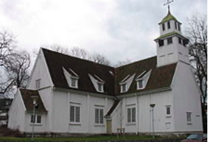
Egersund Church (Norwegian: Egersund kirke) is a parish church of the Church of Norway in Eigersund municipality in Rogaland county, Norway. It is located in the center of the town of Egersund. It is one of the two churches for the Egersund parish which is part of the Dalane prosti (deanery) in the Diocese of Stavanger. The white, wooden church was built in a cruciform style in 1623 using designs by an unknown architect. The church seats about 1,090 people.
The earliest existing historical records of the church date back to the year 1292, but it was not new that year. The first church may have been a stave church and it was dedicated to St. Mary. In 1292 it was written about in a letter from the Pope and it was called "Ecclesia sancte Marie de Eikundasund" (St. Mary's Church of Egersund). Its date of construction is not know, but there is historical evidence to show that a church has been on this site since possibly the 11th century AD. The church was located at Aarstad in what is now the town of Egersund, right along the harbor.
Around the year 1623 or 1624, the old church was torn down and replaced with a new timber-framed long church on the same site. The new church was situated so that the choir was on the east end of the building. In 1726, the church was sold by King Frederick IV to the town judge and two other local businessmen in order to pay down the debts from the Great Northern War. The church was later purchased back by the parish so it was no longer privately owned.
From 1785-1788, the church underwent a massive renovation and expansion project. The church was converted to a cruciform design by adding transverse arms to the north and south sides of the church. The ceilings were raised and vaulted so that tiered galleries were added around the perimeter of the church interior. This expansion greatly increased the capacity of the church and making it the second largest church in all of Stavanger county at that time. In 1927, the church was redecorated and restored to bring it closer to its 17th century appearance.
2. Eigerøy Lighthouse
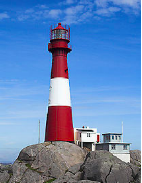
Eigerøy Lighthouse (Norwegian: Eigerøy fyr) is a coastal lighthouse located at the small island of Midbrødøya which is located immediately west of the island of Eigerøya in Eigersund municipality in Rogaland county, Norway. It was established in 1854 and automated in 1989. This was Norway's first cast iron lighthouse, and its success encouraged the building of many more on the Norwegian coastline. The light sits at an elevation of 46.5 meters (153 ft) above sea level, sitting atop a 32.9-meter (108 ft) tall tower. The light emits three white flashes every 30 seconds. The light uses a 1st order Fresnel lens and produces a 3,905,000-candela light. The light can be seen from all directions for up to 18.8 nautical miles (34.8 km; 21.6 mi). The tower is attached to a 2-story service building. The lighthouse is painted red with one white horizontal band. The lighthouse was automated in 1989 and it remains under the control of the Coastal Administration. There are a limited number of tours available. It is accessible by road and the tower is open for touring on Sundays in July.
3. Lappeenranta harbor
We are pleased to welcome you to our first major concert after the corona shutdown in March.
We have with us our oldest students who go to junior high and high schools. Tuva together with approx. 40 other students are on stage this evening and we get to hear and see song, choir, piano, band, dance and theater students through a rich and varied program. Do not miss this opportunity to experience our great young people on stage in Egersund Arena.
Tickets:
Purchased only at www.egersundkulturhus.no
Limiting the number of spectators. We follow the national corona guidelines and have a limit of a maximum of 200 spectators in the hall. Unfortunately, we have to say that each family can bring a maximum of 5 people. Also show consideration for the distance rules on the way into the hall and when waiting in the foyer. The foyer in the Arena has plenty of space so pay attention. The planned opening of the doors is at 19.15. (Everyone is referred so do not arrive too early)
https://eigersundkulturskole.no
六、历史文化
1.历史
The place is mentioned in Snorri Sturluson's writings. Later, Christian IV set up a battery there. The rural parish surrounding the town of Egersund was established as the municipality of Egersund landdisstrikt (Egersund rural district) on 1 January 1838 (see formannskapsdistrikt law). In 1839, the northwestern district of Augne (population: 825) was separated to form its own municipality. On 12 December 1868, a small area of Eigersund municipality (population: 41) was transferred to neighboring Sokndal. In 1947, an area of Eigersund immediately surrounding the town of Egersund (population: 515) was transferred to the town of Egersund and another area in Sokndal (population: 7) was transferred to Eigersund.
During the 1960s, there were many municipal mergers in Norway due to the work of the Schei Committee. On 1 January 1965, the town of Egersund (population: 3,787) was merged with the surrounding municipalities of Eigersund (population: 4,664), Helleland (population: 851), and the Gyadalen and Grøsfjel areas of Heskestad (population: 114). The new municipality was also called Eigersund. On 1 January 1967, the Tjørn farm (population: 10) was transferred from Eigersund to Sokndal. The Old Norse form of the name was Eikundarsund. The first element is the genitive case of the name of the island of Eikund (now Eigerøya) and the last element is sund which means "strait" or "sound". The first element in the name of the island is eik which means "oak" and the last element is the suffix -und which means "plentiful of" (i.e. "the island covered with oak trees").
The Egersund-Ogna anorthosite around Egersund consists mostly of anorthosite, and a little norite in the east. In the more eastern main bodies with the Helleren anorthosite and the Åna-Sira anorthosite, the relationship is reversed - light norite dominates over anorthosite. The two-part Bjerkreim-Sokndal intrusion in the northeast is the youngest, with layers of deep rocks from 1 - 7 km original depth, and deposits of jotunite, apatite, magnetite and ilmenite (FeTiO3) in both the northern Bjerkreim part and the southern Sokndal- the part. In the latter, Titania AS extracts ilmenite for the production of titanium (Ti). The mining operations in Rogaland anthropite province have roots dating back to the 18th century.
Eigersund municipality consists of the mainland and the inhabited island of Eigerøy. The municipality got its current boundaries on 1 January 1965 after the municipal merger of Egersund, Eigersund, Helleland and parts of Heskestad. Eigersund stretches along the coast from Hå to Sokndal and inland, all the way to the county border with Vest-Agder. The land area is 429.6 km², and the municipality has a coastline of 107 km.
The municipality consists on the coast of lowlands with barren and rounded rocks and little vegetation, except around Egersund and the towns Hellvik and Helleland, where Egersund tree planting company has operated and planted trees for over 100 years. Inland, the landscape is steep. In the northeast there are heights of 650-850 masl, but in the southwest the peaks are lower, and are at approx. 250–350 masl The highest mountain in the municipality is Store Skykula (906 m) north of Gyadalen. In the area around Egersund, on the other hand, the heights are around 100 masl.
2. 文化体育
The cultural office is responsible for allocating training times for municipal halls and sports fields. These can be applied for before the first of May and the award will take place in the same month. The allocation period follows the school year.ff the coast and a few miles inland, there are large deposits of the rock type anorthosite. Together with an area in Canada, the area is the largest area on earth. Larger areas are found on the moon. Southwest of Egersund, outside Eigerøy, there is a so-called amphidromic point, ie a zero point in the sea in relation to the tide. Tides from two different directions, namely the English Channel and north of Scotland, meet here and neutralize each other. The result is that there is no difference between high and low tide in Egersund. Along the coast of the west and south, there are also no major tidal differences due to this zero point. The largest lakes are Eiavatnet, Grøsfjellvatnet, Nodlandsvatnet and Teksevatnet.
https://www.eigersund.kommune.no/langtidsleie-idrettshaller-og-gymsaler.4742151.html
七、其他信息
The form of the name spelled without the diphthong [ei] (Egersund) is the Danish language form of the name which is still preserved in the name of the town Egersund, but the municipality name is spelled using the Norwegian language form.
The coat of arms was granted on 20 October 1972. The arms show a gold / yellow oak leaf on a green background. The arms are partly a canting since the name is supposedly derived from Eikundarsund and eik means oak. Oaks are also very common in the municipality.
八、联系方式

Town manager: Leif Erik Egaas
Phone:51 46 80 11
Email:odd.stangeland@eigersund.kommune.no
Address:Veiledningstorget, Nytorget 9, 2nd floor
Postal address: Postboks 580, 4379 Egersund
Instagram: @ordforerieigersund
Facebook: @ ordforer.eiegersund
https://www.eigersund.kommune.no/ordfoerer.4726267-150110.html
