Houten 作者: 来源: 发布时间:2021-10-21
一、人口,面积,所属地区
Location in Utrecht
Coordinates: 52°2′N 5°10′E
Country Netherlands
Province Utrecht
Area
• Total 58.99 km2 (22.78 sq mi)
• Land 55.41 km2 (21.39 sq mi)
• Water 3.58 km2 (1.38 sq mi)
Elevation 2 m (7 ft)
Population (January 2019)
• Total 49,911
• Density 901/km2 (2,330/sq mi)
Time zone UTC+1 (CET)
• Summer (DST) UTC+2 (CEST)
Postcode 3990–3999
Area code 030
Houten is a municipality in the Netherlands, in the province of Utrecht.
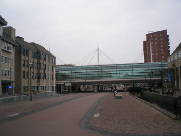
Town hall and station in Houten
二、自然地理
Rail
Houten has two railway stations, Houten (opened in 1868, closed in 1934, re-opened on a different location in 1982 and restructured in 2010) and Houten Castellum (opened in 2010). These stations are served by local commuter trains to Utrecht (northbound) and Geldermalsen (southbound, with subsequent connections to Tiel and 's-Hertogenbosch/Breda). The railway has been doubled from two tracks to four, to accommodate for an extra stop at Castellum with a frequency of four trains per hour in each direction.
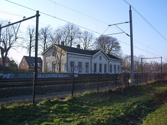
Old railway building
Bus
Busses travel to regional destinations, such as Nieuwegein and Utrecht.
Bike
Like most Dutch cities, Houten is well adapted to the high number of cyclists. Unlike other cities Houten is built around a system of car free public space combined with the infrastructure for slow traffic. The design principle of separating cycling and walking from car traffic has been pushed to the limit. Houten is unique in this. Cycling comfort and safety are extremely high (optimal), even by Dutch standards. A large network of bike paths makes it convenient to cycle to various destinations and within the town the bike is the most popular means of transport.
On October 29, 2008, Houten was chosen as Fietsstad 2008 — the top BikeCity of the Netherlands for 2008. The same happened on January 16, 2018, when Houten was praised for its best all round cycling characteristics and again voted the best Fietsstad 2018 — the nations top BikeCity for 2018. Since the first bicycle city election (held every two years) in 2002 Houten is the only one that managed to win the title twice. The city of Houten is known as, nationally and internationally, and in growing interest from home and abroad, as the worlds best practical example for bicycle friendliness. A growing number of groups with politicians, developers, designers and students visit cycling city Houten for study purposes and inspiration.
Car
To the west, Houten has its own exit from the A27 motorway, and the N409 (single carriageway with bus lane) runs from Houten to Nieuwegein. To the east and south, there are only local roads, not designed for through traffic. A connection to the A12 motorway to the north is the N421 (single carriageway).
The only way to get from one district to another is via the ring road which circles around Houten, thus preventing through traffic in residential areas. Maximum speed on most of the ring road is 70 km/h (43 mph)
三、经济发展和规模
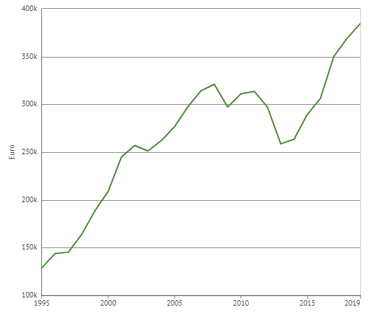
INDUSTRIES: Real estate
Existing own homes; average purchase prices, region
Published by source: 12 February 2020
Expected next release: 12 February 2021

四、产业特点/重点项目
1, Design Spatial Course Houten 2040
The municipality of Houten wants to build approximately 5,800 new homes over the next twenty years. The municipality of Houten has elaborated on what, where and how this is possible in the Design Spatial Course Houten 2040, entitled 'Pleasant living for everyone' . The design was realized with the input of approximately 3,000 people. Residents, social organizations, entrepreneurs and experts contributed
ideas and advised. The college thanks everyone who contributed in any way.
Consultation period extended to June 18
The Board has extended the period of the Design Spatial Course for inspection by 4 weeks. Residents, social organizations and entrepreneurs can therefore submit an opinion up to and including 18 June.
View Design Spatial Course Houten 2040
You can also download and view the complete report Design Spatial Course and the appendices below.
-- Design Spatial Course Houten 2040: Pleasant living for everyone!
https://www.houten.nl/fileadmin/user_upload/Burgers/Wonen_en_leefomgeving/Ruimtelijke_koers/9_april/Ontwerp_Ruimtelijke_Koers_Houten_2040__hoge_resolutie_-gecomprimeerd.pdf
-- Appendix 1: Atlas Workbook :
https://www.houten.nl/fileadmin/user_upload/Burgers/Wonen_en_leefomgeving/Ruimtelijke_koers/9_april/Bijlage_1._Atlas-werkboek.pdf
-- Appendix 2: Study Spatial Models
https://www.houten.nl/fileadmin/user_upload/Burgers/Wonen_en_leefomgeving/Ruimtelijke_koers/9_april/Bijlage_2._Studie_Ruimtelijke_modellen.pdf
-- Appendix 3: Participation: input from residents, civil society organizations and entrepreneurs
https://www.houten.nl/fileadmin/user_upload/Burgers/Wonen_en_leefomgeving/Ruimtelijke_koers/9_april/Bijlage_3._Participatie_-_inbreng_inwoners.pdf
-- Appendix 4a: Research results working groups H 1 to 6
https://www.houten.nl/fileadmin/user_upload/Burgers/Wonen_en_leefomgeving/Ruimtelijke_koers/9_april/Bijlage_4a._Onderzoeksresultaten_werkgroepen_h_1_tm_6.pdf
-- Appendix 4b: Research results working groups H 7 and 8
https://www.houten.nl/fileadmin/user_upload/Burgers/Wonen_en_leefomgeving/Ruimtelijke_koers/9_april/Bijlage_4b._Onderzoeksresultaten_werkgroepen_h_7_tm_8.pdf
Ask?
Do you have any questions about the Spatial Course Houten 2040? Call the municipality and ask for Remko Stinissen or Dominique Smeets via (030) 63 92 611.
2, New impulse for Bos Nieuw Wulven recreation area
Implementation Het Nieuwe Bos Wulven has started
On Monday, March 16, 2020, work will start on the construction of the new exit and the parking area of Het Nieuwe Bos Wulven.
The immediate neighbors were informed of this by contractor Van Wijk Nieuwegein BV in a letter to residents.
The work is expected to last until September 15, 2020. The cycle route through the Nieuwe Bos Wulven will remain open. The Rondweg will be closed in one or two directions for a few days during the work. When that happens, it will be indicated with signs and announced in the media.
Zoning plan for Het Nieuwe Bos Wulven irrevocable
The city council adopted the zoning plan on October 15, 2019.
The appeal period for the zoning plan Het Nieuwe Bos Wulven has expired. No appeal has been lodged with the Council of State. The zoning plan is therefore irrevocable since January 10, 2020. This means that the exit and the parking area may be constructed.
The sequel
The work for this will start in March 2020 with, among other things, moving the young trees along the Rondweg and on the nut field in the forest. Local residents will be informed about the work via the contractor.
It is expected that the initiator Natural Recreation Nieuw Wulven BV will submit an application for an environmental permit for the construction of the restaurant and workshop within a few months. The procedure for granting the permit takes approximately two months, after which construction can start.
Preliminary planning
-- Adoption of zoning plan by municipal council: October 2019
-- End of appeal period: January 2020
-- License application: mid-2020
-- Start construction exit Rondweg: early 2020
-- Start construction catering and recreational facilities: end of 2020
-- End of 2021 / early 2022: opening of new location
Bos Nieuw Wulven
Bos Nieuw Wulven was created as a recreation area 20 years ago. The forest is intended for the inhabitants of Houten, Bunnik and the region. Research shows that they experience a shortage of recreational opportunities in the area. To meet their needs, the intention is to improve the range of facilities and accessibility of Nieuw Wulven.
Natural Recreation Foundation is the new entrepreneur in Nieuw Wulven. They made the plan “Het Nieuwe Bos Wulven”. It describes how they are going to make the forest a place for recreationists of all ages. The foundation wants to offer catering and (free) recreational facilities. In this way, visitors can discover Nieuw Wulven in an accessible, playful and sporty way. Culture, nature and the visitor are central to this.
The Foundation also ensures social connection. There will be learning and work programs, among other things. The Foundation will develop approximately 1 hectare right next to the play forest (total area is 106 hectares). The free facilities that will be built are in line with the play forest, the route structure and the needs of the region. For good accessibility, there will be an exit from the Rondweg van Houten. This exit is located between the De Weide exit and the Het Veld exit. The exit leads to a new parking lot.
3, Grassen building plan (Hofstad IVb)
Houten gets a new residential area in the Grassen. A maximum of 220 homes will be built in the area between the Het Gras exit, the combined heat and power plant and De Limesschool.
There is room for terraced houses, apartments and park houses in three different sub-areas (see allotment map). The building height varies from 10 meters on the side of the existing houses to a maximum of 16 meters near the railway line.
Schedule
BP procedure April 2020 - October 2020
Design of public space (in consultation with residents group Lemongrass) on an ongoing basis
Archaeological research Bronze Age site May - June 2020 2020
RCE permit for furnishing and housing. Permit has been issued
Site preparation (time limit 12 weeks) 4th quarter 2020
Start housing 1st quarter 2021
Site preparation, installation from 4th quarter 2021
Completion of the last homes at the end of 2023
Construction traffic
Construction traffic uses the temporary Raaigras road. This road runs from the exit Het Gras along the railway towards the combined heat and power plant. Construction traffic for De Grassen Noord also uses the Raaigras.
Archaeological excavation in De Grassen
Archaeological research in Hofstad IVb has started. ADC ArcheoProjects, which is conducting this research, publishes a free newsletter about their findings. You can register for this via this link: https://www.archeologie.nl/nieuws/houten
Or read the newsletter online
https://mailchi.mp/46f537f591d3/nieuwsbrief-adc-archeoprowerpen-3881577
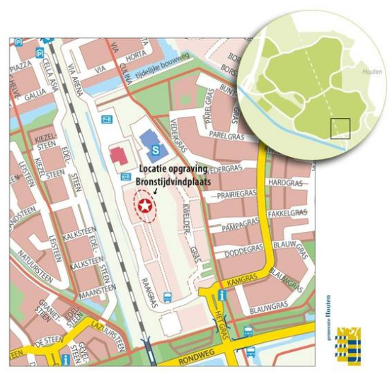
The municipality of Houten wants to build houses in Houten South, south of the combined heat and power plant on Raaigras. However, the site is a special place because it is an archaeological national monument. This means that it is a site with cultural heritage, because on or in the soil remains, objects or other traces of human presence in the past have been preserved. A test excavation has already been done here. Then the area was partially explored with narrow excavation trenches. This trial excavation has shown that there are at least two sites within the boundaries of the monument.
The youngest is from the Iron Age / Roman era (800 BC - 450 AD) and contains remains of a settlement along a water channel. These remains are scattered all over the area. The oldest and second site is from the Middle Bronze Age (1800 - 1100 BC). This much smaller site also contains remains of a settlement.
Performance of the work
In the week from 13 to 17 April, the site will be fenced off with construction fences. The protective soil layer will be excavated in the week of April 20. The archaeological investigation will start on 6 May, which will take approximately 7 weeks.
Do you have any questions or remarks?
Then you can contact the project manager, Mr Jules Tonneijck, Spatial Development department via (030) - 63 92 611 or send an email to Gemeentehuis@houten.nl .
You can also visit www.hofpark.nl .
4, Conversion of the former office building "De Citadel" on Koningsspoor
In this project, the former office building 'de Citadel' on the Koningsspoor will be converted into an apartment complex. Here, Bouwbedrijf De Waal Utrecht is building a total of 124 apartments for rent in the free sector. These have different dimensions and are gasless. The rental price is from € 775, =. Month. This development started in 2016.
The municipality issued the environmental permit in December 2018.
In November 2019, the first 40 tenants received the keys to their new homes. In the spring of 2020, De Waal will deliver the other 84 homes in two phases. Tenants have now been found for all apartments.
For more information: http://wonenindecitadel.nl
5, De Grassen Noord residential area (De Kiem van Houten)
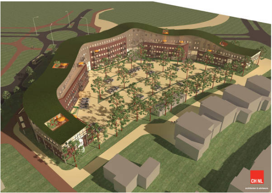
Houten is getting a new neighborhood: De Grassen Noord. This is located between the neighborhoods De Tuinen, Castellum and De Grassen and is called “De Kiem van Houten”.
A total of approximately 300 homes will be sustainable and Zero Op de Meter (gas-free). A number of homes will be life-cycle proof with a lift of your choice. Social housing will also be realized within the plan. These will probably be located in an apartment complex with approximately 92 rental apartments near primary school De Vlinder. Whether there will be more rental properties will be examined in Phase 2. The public area will be climate-proof, taking into account sufficient water storage and good biodiversity.
Would you like to be kept informed about the progress of the work? Then take a look at the https://dekiemvanhouten.nl/nieuws/
Access to Kamgras for 1 st residents De Kiem van Houten
The first homes in the new construction plan De Kiem van Houten will be completed at the end of June / beginning of July. The residents of these houses move in soon after. This means that they will use the Kamgras, the access road for the Grasses, to get to their house.
The Kamgrass is extended to De Kiem van Houten near the Dwarfgrass. Here the road runs via a so-called bayonet connection over the Krommeslootpad and then further into the new neighborhood.
These (new) residents of Houten can easily find their (Round) way in Houten.
Schedule
March 2019 Start of remediation and construction preparation work on the site
End of quarter 2 2019 Start of sale of Phase 1A and 1C for more information www.dekiemvanhouten.nl
September 2019 Start of construction of first homes Phase 1B
Quarter 3 2020 Completion of first homes Phase 1B
Quarter 3/4 2020 Preparation for housing of the first sub-phase, including realization of the connection to Kamgras street
Garden of the Gardens
The Garden of the Gardens is an initiative of some local residents of the Narcissus garden, which is located opposite the De Kiem van Houten new-build plan. The idea is to connect existing and new residents with a joint 'green' project. This can also be used to provide education. The Garden of Gardens has received the public award Green Choice 2018 from the Sustainability Fund Houten!
More information can be found at. https://www.tuindertuinen.nl/ .
More information?
Zoning plan Hofstad III Loerik V and Exploitation plan Hofstad III Loerik V Southwest. ( https://0321.ropubliceer.nl )
Register as an interested party? Go to the website of www.dekiemvanhouten.nl
Do you have any questions or remarks?
If you have general questions about the project, please contact the project manager of the municipality, Mr Jules Tonneijck, Spatial Development department via (030) 639 26 11 or via e-mail: Gemeentehuis@houten.nl .
6, Preparing the work landscape Meerpaal for housing
Various buildings are being built in the Werk Landschap Meerpaal business park (streets ending in Hoon). That is why it is now time to finally design the public space, such as roads and verges.
This work will be carried out in the months of June to October 2020 by the contractor Peek infra & Bouw bv from Houten. The aim is to have the activities take place with the least possible disruption to your business operations or
resident / visitor traffic.
In the first phase of the works, a diversion will be set up for through traffic between the De Rede road and the Veerwagenweg. The diversion drawing is added in pdf on the right. The redirect will be set between June 15 and July 17, 2020.
If you have any questions for the municipality about the work, please contact Mr. A. de Reuver, on (030) 63 92 611.
If you already have questions for the contractor company Peek infra & Bouw bv, please contact Mr. R. Entrop, via (030) 63 71 472, or by email at r.entrop@peekbv-houten.nl .
7, Work on A27 Houten - Hooipolder
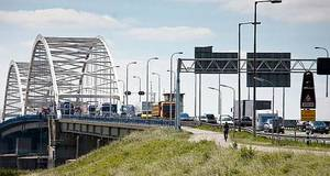
Motorists are stuck in traffic jams almost every day on the A27 between Houten and the Hooipolder junction.
To improve traffic flow, Rijkswaterstaat is widening the road.
Work to widen the A27 between Houten and the Hooipolder junction will start in 2022. Until then, Rijkswaterstaat will investigate the project area and, where necessary, carry out preparatory work.
More information can be found at www.a27houtenhooipolder.nl .
Or follow Rijkswaterstaat on
https://www.facebook.com/Rijkswaterstaat/?__tn__=%2Cd%2CP-R&eid=ARCKDotXSfBglj8X01V9JXZ3QhpBySXlgo5RyfeH8j0Z-wKEIzbiJyyBZVbfX6kYUzocJLUM_MlP13f8
8, Developments Island of Schalkwijk
Future projects
The municipality also badly needs the land to strengthen the Lekdijk. The water board will start work on the Sterke Lekdijk project from 2024 . This project makes the entire dyke stretch future-proof. Of course also the part that is in the municipality of Houten.
The land exchange will also make a place available in the village for a residential and daytime activities location for young adults with a mental disability. The municipality is further investigating how we can solve the problems surrounding traffic and parking at Sportpark Schalkwijk. The road surface of the Kanaaldijk Zuid is being tackled and improved.
Relocation of farms
To make these developments possible, one agricultural company is moving from Lekdijk 28 to a new location on the Trip. Another agricultural company is moving from Lagedijk 1 to Kanaaldijk Zuid. This new company combines agriculture and education. It shows visitors where food comes from. Homes will be built on the vacant lots.
New construction homes
In 2011, the policy for the spatial development of Eiland van Schalkwijk was established. This document is called ' Structural Vision Island of Schalkwijk' . This stipulates that new developments in the field of agriculture and recreation are highly desirable. They have to strengthen the area and add quality to the island. We can earn the money for these developments with housing. The province has given permission for limited housing in the rural area - outside the red contour. That is why houses are being built on the Lekdijk and the Lagedijk.
The municipality of Houten makes the plans for housing on the Lekdijk itself. The local residents are allowed to contribute ideas about what the houses will look like. And also about the exact place where they are built. The aim is to start this in the second half of 2020.
The municipal council will discuss the proposal for land purchases and land exchanges in March 2020. After that, the municipality will draw up a budget to identify costs and revenues. The city council discusses this budget between April and June. If the council agrees with the proposals, the projects will start in 2020.
Enjoy to the full
In recent years, all kinds of great plans have been implemented to allow residents and visitors to enjoy themselves more. Such as clog paths, tea gardens, bed & breakfast, a renovated fort with camping and terrace, canoe routes and jetties, a restaurant, a regional transferium and points of sale for regional products. At the VVV Krommerijnstreek you will find information about recreational opportunities on the Eiland van Schalkwijk.
Do you have a good plan for the Island?
We challenge residents and entrepreneurs to invest in this area. Submit your plans to us. We are happy to think along with you!
Please feel free to contact us. Call or email:
Gemeente Houten Area
Manager: Salihe Seyman
Telephone: 030-6392 611
Email: Gemeentehuis@houten.nl
9, Residential construction on Lekdijk 28
In March 2020, the municipality bought 39 hectares of agricultural land at the Trip on Eiland van Schalkwijk. The city council unanimously agreed to this decision.
The farm, which is still located at Lekdijk 28, will move to this location. This is the first step to strengthen the agricultural structure of Eiland van Schalkwijk. In this way, the municipality helps the farmers in Schalkwijk to get larger plots. This means that the companies are better prepared for the future.
Experiment status Eiland van Schalkwijk
Due to the relocation of the agricultural company, the farmers exchange a total of approx. 110 hectares of land on the Eiland van Schalkwijk. In order to be able to pay for this relocation and exchange of land, the municipality may build homes on the vacant lot at Lekdijk 28. This is the result of the 'Experimentation status' on Eiland van Schalkwijk (from the Provincial Spatial Structural Vision 2013-2028). This status means that if residents or land owners on the Eiland van Schalkwijk have plans to improve the recreation and / or the agricultural structure and / or the water management on the island, a few homes may be built to pay for those plans.
There are two options for the construction of the houses:
-- 11 homes on the Lekdijk or
-- 8 homes on the Lekdijk and 6 homes on the Kaaidijk.
New Dutch Waterline and dyke improvement
This has to do with the costs and revenues of building Lekdijk 28. Perhaps 11 homes cannot be built here. Because the Lekdijk is part of the New Dutch Waterline (NHW). The NHW is nominated to become Unesco World Heritage. This means that the elements from the Dutch Waterline, in this case the Fort Werk aan de Groene Weg, must remain visible and perceptible. The firing field around the fort therefore remains open. This is 300 meters all around.
And the Lekdijk is also an important place for future dyke improvement. To reserve space for dyke improvement, the water board has claimed 'free space'. No houses may be built there. Because of all these factors, the municipality, together with the province and HDSR, is drawing up a Heritage Impact Assessment (HIA). The municipality will process the results of this in an urban development and visual quality plan.
Participation
The municipality is happy to provide clarity to local residents and residents of Schalkwijkj about what the location might look like in the future. Via interactive design sessions with local residents, the municipality collects ideas for the urban development plan and the image quality plan.
10, Mobility vision Eiland van Schalkwijk 2017-2027
From vision to implementation
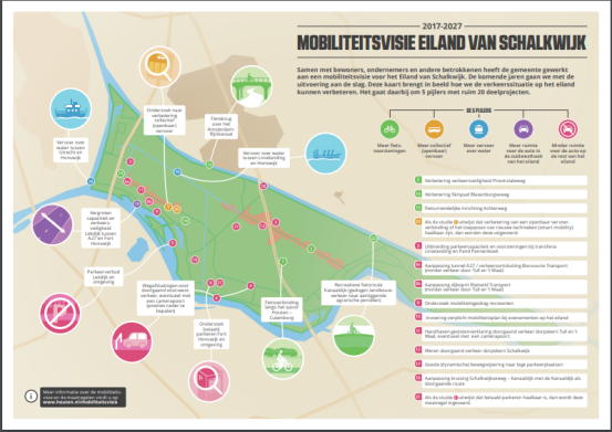
Last year, the city council unanimously approved the Mobility Vision Eiland van Schalkwijk 2017-2027. The vision shows how we can improve the traffic situation on the Island in the coming years and how we make developments possible. The focus is on improving bicycle use, water transport, more and better public transport, and widening the road on the Lekdijk between A27 and Fort Honswijk. All plans can be seen at a glance in an infographic (see download on the right side of the page).
The mobility vision is based on the developments as laid down in the Island of Schalkwijk Structural Vision. The mobility vision also takes into account the proposed more intensive use of the 't Waal recreation area and the redevelopment of Fort Honswijk. The vision was created in an intensive participation process with residents and entrepreneurs of the island.
Two motions were passed during the council's debate (see downloads). The content of these two motions will be included in the elaboration of the vision. The council has made € 1,000,000 available to get started on the implementation of the vision.
Sequel
The mobility vision is a vision document. This means that it indicates a mindset, but does not yet contain any concrete plans. The elaboration is done together with those involved. In the meantime, the first projects have started. You can find a more detailed description of the implementation projects here. For 2018, this includes a bicycle connection along the Houten-Culemborg track, improving the road safety of the Provincialeweg., research into collective public transport and the mobility behavior of recreational users. The introduction of camera ports will be delayed for some time to come. At the request of the municipal council, this will be delayed until the urgency has become clearer. On March 13, 2018, the Board of b. and W. established the project plan stating how the project will be rolled out. The project plan is available for download on the right.
Do you have questions?
Please contact the project leader, Mr. Edwin Boonstoppel, Spatial Development department on 06 3304 3338. You can also send an email to Gemeentehuis@houten.nl .
11, Tonnage restriction Bridge 2030 Groeneweg - Achterdijk in Schalkwijk
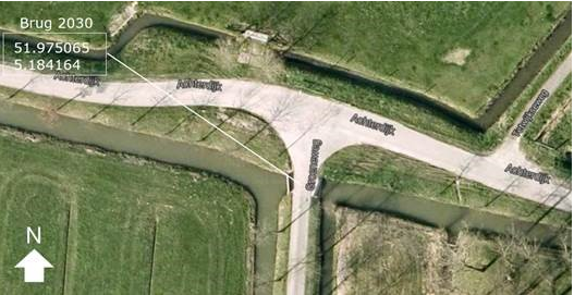
During inspection work, collision damage was found to bridge 2030 Groeneweg - Achterdijk (see aerial photo) in Schalkwijk. The damage is so great that the structural safety of the bridge must be assessed. In order to guarantee the safety of road users as much as possible, the bridge is closed to vehicles heavier than 2.5 tons. Vehicles subject to the restriction can detour in an easterly direction via the Achterdijk - Pothuizerweg - Scheidingweg - Lekdijk and in a westerly direction via the Achterdijk - Lange Uitweg - Lekdijk. How long it will take to determine the structural safety of the bridge is currently unforeseeable. As soon as it has been established that the bridge is still / again structurally compliant for all traffic, the tonnage restriction will be lifted.
12, Wickengaard Schalkwijk housing development
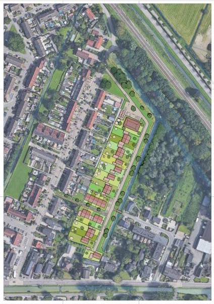
Dura Vermeer BV and the land owner want to build 33 homes on the plot behind Jhr. Ramweg 26.
We have entered into an agreement with Dura Vermeer for this purpose, which stipulates that the necessary zoning plan changes will be submitted to the municipal council.
The plan is as follows (see also the plan map under Downloads):
-- 8 apartments of approximately 50 m² up to a von price of approximately € 220,000 (price level 1-1-2018)
-- 3 apartments of approximately 80 m² to a von price of approximately € 265,000 (price level 1-1-2018)
-- 8 terraced houses
-- 8 semi-detached houses
-- 6 detached houses
Orchard
There is a production orchard on the site with some 1,500 pear trees. Studies indicate that the low stammer trees have little natural or cultural-historical value. The trees are not on the list of 'trees of special value' and may in principle be felled.
Participation
There was a walk-in evening on 20 March 2019. All questions from visitors, with the corresponding answers, are included in a note. This has been sent to the visitors.
In response to the questions and comments, the housing program has been changed on a number of points. The changes have been incorporated into the allotment (see also the plan map under Downloads). Local residents have presented a petition to Alderman Hilde de Groot with the request to keep the orchard.
Water problems Wickenburghselaan
The residents on Wickenburghselaan approached us about possible water problems in their garden and sheds. Engineering bureau Movares has investigated this and has proposed a new continuous rear path with new larger water discharge pipe. November 18 was discussed with the residents concerned. The report has been circulated.
On March 5, Dura Vermeer presented the detailed plan for the new rear path and the new water drainage pipes. The report of this meeting is sent to the concerned residents.
Schedule
In order to enable the construction of the houses, a new zoning plan will have to be adopted by the municipal council. The design of the zoning plan will be made available for inspection in mid-2020. Then any interested party can submit an opinion. Before the plan is made available for inspection, all immediate residents will be notified personally.
The draft zoning plan is expected to be discussed in the city council on September 29, 2020.
Do you have any questions or remarks?
Please contact the project leader Mr Pim de Moed, Spatial Development department via tel. (030) 63 92 611 or send an email to Gemeentehuis@houten.nl .
More information about the plan can be found on the developer's website: www.wickengaard.nl .
13, Kerkebogerd / Buitenoever in Tull and 't Waal
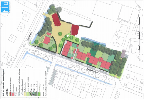
This project has been running since 2007. The construction of the houses here is going in two phases.
Developer Dura Vermeer BV builds the first 28 homes. These are located west of De Kerkebogerd. These homes are almost ready. The last new residents expect the key in January 2020. In the course of 2020, Dura will also build the house on the Lekdijk.
HBC Planontwikkeling is developing and building the second phase on the east side of Kerkebogerd. These are 10 more homes. Construction will start in 2020. The houses will be ready in early 2021.
To make this construction possible, HBC is demolishing the old house on the site of the church. Ultimately, a new home for the pastor will be built for this purpose. All homes have already been sold.
For more information:
https://www.buitenoever.nl/
and https://www.hbcplanontwikkeling.nl/projecten/tull-en-t-waal-waalseweg/
14, Tuurdijk 't Goy residential building
In January 2018, the municipality bought plots on Tuurdijk in 't Goy to have homes developed there. An initial memorandum for this was drawn up in July 2018. See download right side. This initial memorandum includes rough starting points for the further development of the location. Due to the need for a considerable number of starter homes in 't Goy, a sketch allotment has been made with, among other things, 8 terraced houses, of which the middle 6 are starter homes.
Design zoning plan for the new construction of Tuurdijk 't Goy available for inspection
The design zoning plan for the Nieuwbouw Tuurdijk 't Goy is formally available for inspection until April 30, 2020. Knowing more?
View the information here
https://www.houten.nl/burgers/wonen-en-leefomgeving/ruimtelijke-plannen/bestemmingsplannen-en-beheersverordeningen/bestemmingsplan-tuurdijk-1-3-t-goy/
Sale
In November 2018, developers and builders were asked to submit a bid and an action plan for this location by December 14, 2018. The land has now been sold to CZP Investments BV
Sequel
The process with CZP was complicated and took a long time. The allotment and the program have been slightly adjusted. See download right side. CZP now first draws up a building plan in consultation with residents and other stakeholders. This concerns the housing designs and layout plans for the area. After these have been worked out, the Municipal Executive will take a decision. After that, CZP must follow a planning procedure to apply for an environmental permit. You will find this request in the municipal page of Houtens Nieuws in due course.
The municipality expects the planning procedure to be ready in 2020. Depending on the progress of this entire process, construction will start in 2021.
Do you have any questions or remarks?
Then you can contact the project leader, Mr. Pim de Moed, Department of Spatial Development via (030) 63 92 611. You can also send an email to Gemeentehuis@houten.nl
五、风景名胜,景点
Amelisweerd
Expansive, peaceful riverside park known for tranquil forests, walking trails & canoeing.
Website: https://www.vriendenvanamelisweerd.nl/
Het Verdronken Bos
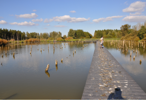
Nature preserve in Tull en 't Waal, Netherlands
Good for kids
Address: Tull en 't Waal, Netherlands
Phone: +31 343 575 995
六、历史文化
Remains of a Roman villa have been found in the old centre of Houten, made visible in a street pattern. There used to be a Roman villa on that spot. This building was discovered in the fifties. In the Dark Ages Houten took shape as a rural centre. The area of the municipality of Houten was divided in the so-called 'gerechten' (districts). The names of these districts are still in use: Schonauwen, Wulven, Waijen, Heemstede.
A lot of elements in present-day Houten are reminders of its history. Prominent in the old centre 'Het Oude Dorp' are the Roman Catholic Church (1884) and the Protestant Church (1563). The first accounts of this church date from the ninth century, the oldest parts of the church are probably from the eleventh century. Another prominent building is the restaurant/cafe 'De Engel', already mentioned in the 16th century as a tavern.
Former access roads to the old centre are still recognisable by their names, such as the 'Odijkseweg' and 'Loerikseweg'. Houten had many orchards, but few have survived.
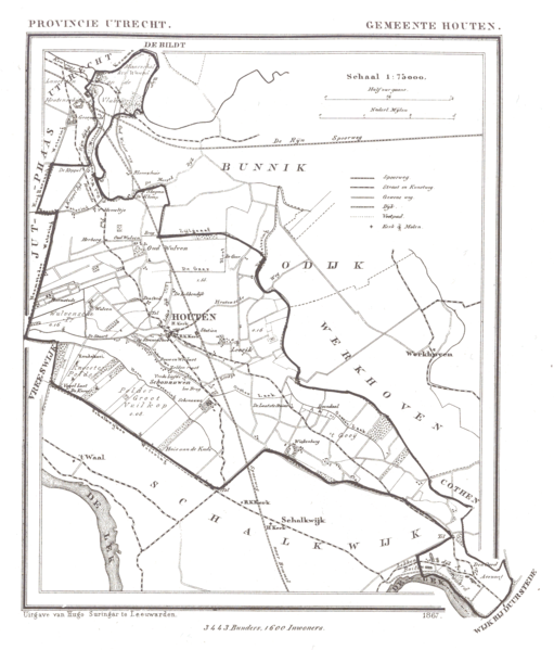
Historical map of Houten
The expanding city 1966–1998
Modern Houten started to take shape in the last decades of the 20th century (1966–1998). It was first designated by the office of Wissing-Derks as a 'Groeikern' – a centre of growth – to meet the needs of the growing city of Utrecht. From the beginning urban planner-designer Robert Derks was involved with the development of the New Town Houten. In 1979 the construction of 10,000 dwellings started and the population grew from 4,000 to more than 30,000 late in the nineties.
Second designation as a centre of urban growth 1992–2015
Until 2015, some 7,000 new houses are being built in Houten-Zuid, following the same urban design principles as the existing Northern part of Houten, but with some differences. The body of water to the east is large in comparison with water bodies in the old parts of Houten. The pentagonal green zone in Houten-Zuid embracing the centre is different from the greenzone in Houten-Noord, which runs through the whole city in a linear structure, crossing the new city centre and with larger parks at either end. Another difference is that in some places cars share the road with bicycle paths (this concept was later applied in the northern part as well). The southern part was also designed by Robert Derks and his office for urban design Stedebouw BV.
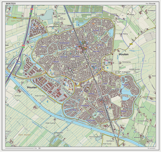
Dutch Topographic map of Houten (town), March 2014
七、其他信息
Urban planning and architecture
Sustainable urban design
Houten is internationally known for its urban design. Because of the city structure, people are encouraged to travel by bike and train. Distinctive qualities of Houten include the accessibility of the railway station, green and water zones throughout the whole city, numerous soccer and basketball fields, high standard of accommodation for different groups and the child-friendly bicycle paths. It is one of the safest cities in the Netherlands. Cyclists and cars are able to avoid each other: an extensive network of bicycle tracks connects the different districts of the town, while cars have to go to the city ring road before they can go to another part of the city.
Thomas House is a small-scale housing complex in Houten for adults with intellectual disabilities, opened in 2013.
Remarkable buildings in Houten
-- Aluminiumcentre Aluminium wood (Micha de Haas)
-- Pyramid-shaped apartment complex Het Domein (Das brothers, Alberts & Van Huut))
-- Total petrol station (Samyn and Partners)
-- Fire department (Samyn and Partners)
-- De Kniphoek - Rietplas (Hans Been Architecten)
-- The Golden House (Micha de Haas)
-- railway station bicycle transferium (Movares\StudioSK, Henk Woltjer)
-- JOINN! (De Wit architecten)
Archeology
The habitation of Houten has a very long history. Traces in the soil testify to this. Based on these traces, it is known that people lived here about 4 millennia ago and that human habitation became more permanent in the Iron Age (ca 650 BC - 15 BC).
Locations of human activities are known in the municipality of Houten from this period and subsequent periods. Of great importance are the traces of human settlements from the Iron Age, Roman Period and the Middle Ages.
There are 18 archaeological national monuments and more than 140 sites with archaeological value in Houten. These monuments cannot be seen above ground, such as buildings. In addition, a very large part of the territory of Houten (especially the high-lying grounds) has a high probability of finding archaeological finds.
Monuments
Houten has both national and municipal monuments . Monuments are often thought of as special buildings. But bridges, cemeteries, fences and other objects can also be a protected monument. Houten also has archaeological monuments ( see under 'archeology' ).
National monuments represent a certain cultural-historical, architectural-historical and / or urban development value from a national perspective. Examples in Houten are Schonauwen castle, Wickenburgh country estate and Honswijk fort.
Municipal monuments have cultural-historical, architectural-historical and urban development value at the local level. The protection of municipal monuments is regulated in the municipal heritage regulation.
Population centres
The municipality consists of the following towns:
-- 't Goy
-- Houten
-- Schalkwijk
-- Tull en 't Waal
Houten (town)
The main town in the municipality is Houten, a commuter town about 9 km southeast of Utrecht. On 1 January 2020, the town had 50.177 inhabitants (municipality). The built-up area was 5.08 km2 (1.96 sq mi) in area, and contained 20,010 residences in 2018. The slightly larger statistical district of Houten had a population of about 39,100 in 2004.
八、联系方式

Gilbert Isabella
Contact details
Telephone: (030) 63 92 611
Email: Gemeentehuis@houten.nl
Postal address: PO Box 30, 3990 DA Houten
Visiting address: Onderdoor 25, 3995 DW Houten
Fax: (030) 63 92 899
https://www.houten.nl/
WhatsApp : 06-12848922
Facebook: Gemeente Houten @gemhouten
Twitter: Gemeente Houten @gemHouten
