Weesp 作者: 来源: 发布时间:2021-10-20
一、人口,面积,所属地区
Location in North Holland
Coordinates: 52°18′N 5°3′E
Country Netherlands
Province North Holland
City Hall Weesp City Hall
Area
• Total 21.83 km2 (8.43 sq mi)
• Land 20.51 km2 (7.92 sq mi)
• Water 1.32 km2 (0.51 sq mi)
Elevation 1 m (3 ft)
Population (January 2019)
• Total 19,334
• Density 943/km2 (2,440/sq mi)
Demonym(s) Weesper
Time zone UTC+1 (CET)
• Summer (DST) UTC+2 (CEST)
Postcode 1380–1383
Area code 0294
Weesp is a city and municipality in the province of North Holland, Netherlands. It had a population of 19,334 in 2019. It lies on the river Vecht and next to the Amsterdam–Rhine Canal in an area called the Vechtstreek. Weesp is part of the Amsterdam metropolitan area even if the city is surrounded by open grassland and lakes.
On 1 June 2019 the civil service offices of the municipality of Weesp merged with those of the municipality of Amsterdam in preparation of the merger of the two municipalities, which is supposed to happen on 24 March 2022.
二、自然地理
Transport
Weesp railway station
Weesp is a railway station in Weesp, Netherlands. The station has 2 island platforms and it has a total of 6 tracks, from which 2 tracks are for passing trains. The first station in Weesp opened in June 10, 1874, when the Gooilijn from Amsterdam to Hilversum and Amersfoort was completed. The original station was demolished in 1967 and replaced by a new building. The new building partially went out of service in 1985 because of the new railway line from Weesp to Almere and beyond, called the Flevolijn. The out-of-service part was later converted to a bicycle parking and repair shop. The remaining station is little more than a tunnel passing under the tracks, and a small coffee counter. Train services are operated by Nederlandse Spoorwegen.
Since the opening of the Flevolijn, Weesp has been a major transfer station for passengers travelling from Amsterdam Central Station and Schiphol from the east, and suburbs such as Almere and Hilversum to the west. Due to this circumstance, Weesp features 16 departures per hour. Until 2003, also passagers travelling between Hilversum and Almere had to change at Weesp. In that year a new branch, the Gooiboog, was added to connect the line towards Almere with the line towards Naarden-Bussum railway station and Hilversum.
The traveling time from Weesp to Amsterdam Centraal by train is about 15 minutes. The distance between the two is about 15 kilometers.
三、经济发展和规模
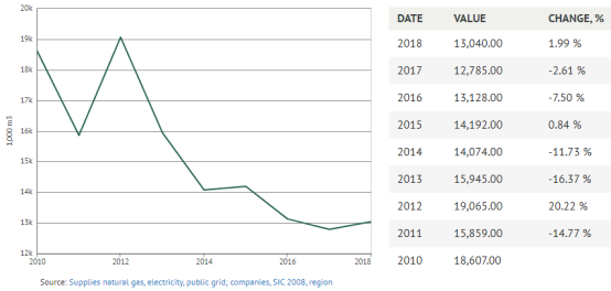
Total » Total » A-U All economic activities - Weesp - Natural gas, delivered
13,040.00
1,000 m3 in 2018
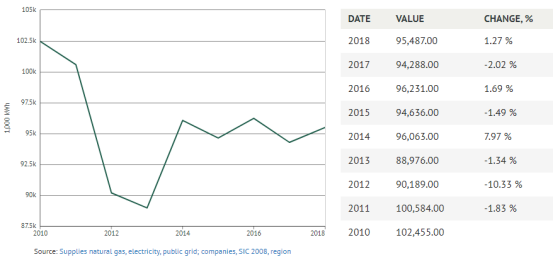
Total » Total » A-U All economic activities - Weesp - Electricity. delivered
95,487.00
1,000 kWh in 2018
四、产业特点/重点项目
The most famed product of Weesp is Van Houten chocolate. Before cocoa production, the local economy had been based on beer breweries, jenever distilleries, production of Weesper porcelain, and trade, due to its location on a branch point of waterways. In the 21st century, the economy is very diverse.
There were large facilities of Solvay Pharmaceuticals, until February 2010 when Abbott Laboratories of North Chicago, Illinois acquired Solvay Pharmaceuticals. At this site there is a chemical plant which manufactures active pharmaceutical ingredient for Abbott brands Duphalac and Duphaston and a biologic plant which manufactures active pharmaceutical ingredient for Abbott's flu vaccine Influvac. The local specialty is the Weesper Mop cookie, which is based on mashed almond.
五、风景名胜,景点
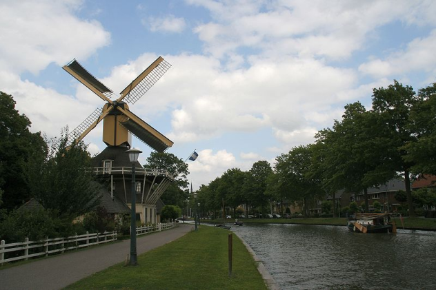
Weesp is a popular stop for tourists. It has a protected historical center with canals and many buildings dating from the seventeenth and eighteenth century. Weesp has three full-size historical windmills. It features a bastion and fortifications that are part of the Defense line of Amsterdam and the Dutch Water Line. These structures have never been attacked, though. The scenic river Vecht and the small roads that line it attract yachters and cyclists. The Naardermeer area, the first nature reserve in the Netherlands, is at 15 minutes cycling distance from Weesp; it protects the Gooi landscape. The Weesp local museum is located in the town's city hall.
Muiderslot
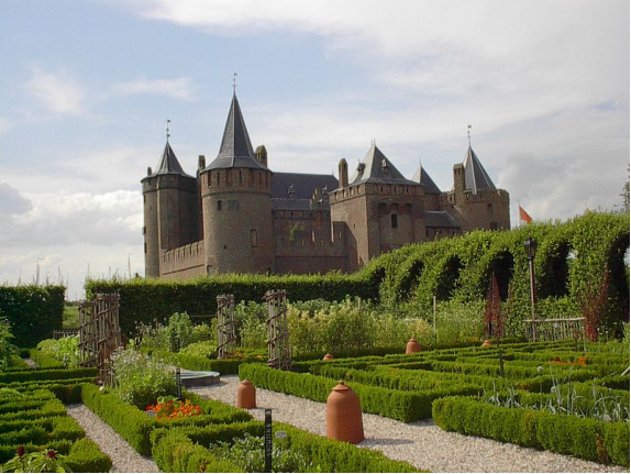
Muiden Castle is a castle in the Netherlands, located at the mouth of the Vecht river, some 15 kilometers southeast of Amsterdam, in Muiden, where it flows into what used to be the Zuiderzee. It is one of the better known castles in the Netherlands and featured in many television shows set in the Middle Ages.
Address: Herengracht 1, 1398 AA Muiden, Netherlands
Phone: +31 294 256 262
History
Floris V
The history of Muiden Castle begins with Count Floris V who built a stone castle at the mouth of the river in 1280, when he gained command over an area that used to be part of the See of Utrecht. The Vecht river was the trade route to Utrecht, one of the most important trade towns of that age. The castle was used to enforce a toll on the traders. It is a relatively small castle, measuring 32 by 35 metres with brick walls well over 1.5 metres thick. A large moat surrounded the castle.
In 1296, Gerard van Velsen conspired together with Herman van Woerden, Gijsbrecht IV of Amstel, and several others to kidnap Floris V. The count was eventually imprisoned in Muiden Castle. After Floris V attempted to escape, Gerard personally killed the count on the 27th of June 1296 by stabbing him 20 times. The alleged cause of the conflict between the nobles was the rape of Gerard van Velsen's wife by Floris.
In 1297, the castle was conquered by Willem van Mechelen, the Archbishop of Utrecht, and by the year 1300 the castle was demolished.
Fourteenth century
A hundred years later (ca. 1370-1386) the castle was rebuilt on the same spot based on the same plan, by Albert I, Duke of Bavaria, who at that time was also the Count of Holland and Zeeland.
P.C. Hooft
The next owner of the castle shows up in the 16th century, when P.C. Hooft (1581-1647), an author, poet and historian took over sheriff and bailiff duties for the area (Het Gooiland). For 39 years he spent his summers in the castle and invited friends, scholars, poets and painters such as Vondel, Huygens, Bredero and Maria Tesselschade Visscher, over for visits. This group became known as the Muiderkring. He also extended the garden and the plum orchard, while at the same time an outer earthworks defense system was put into place.
18th and 19th century
At the end of the 18th century, the castle was first used as a prison, then abandoned and became derelict. Further neglect caused it to be offered for sale in 1825, with the purpose of it being demolished. Only intervention by King William I prevented this. Another 70 years went by until enough money was gathered to restore the castle to its former glory.
Modern times
Muiden Castle is currently a national museum (Rijksmuseum). The inside of the castle, its rooms and kitchens, was restored to look like they did in the 17th century and several of the rooms now house a collection of arms and armour.
Fort Uitermeer, the beacon on the Vecht

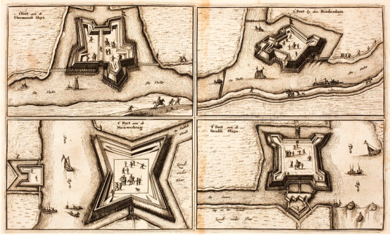
The Fort Uitermeer is an old fort that is included in the New Dutch Waterline and later the Defense Line of Amsterdam . It is located in the North Holland municipality of Weesp on the east bank of the Vecht , southeast of Weesp near the hamlet of Uitermeer . To the southwest is the Fort at Hinderdam and to the northwest is the Vesting Weesp .
The purpose of the fort was to protect the land passages between the Naardermeer and the Vecht. The two most important passages were the Amsterdam - Amersfoort Railway and the Hilversum to Weesp road (along today's N236 ). It could also support the neighboring forts with its artillery. It also protected the lock with which the land could be flooded.
History
Sconce
Around 1589 one was in the place of the current fort fort built to defend Weesp . After the digging of the 's-Gravelandsevaart and the construction of the lock , the Uitermeersche Schans became a link in the Old Dutch Waterline . The redoubt was strengthened to a fort in 1673 around the lock, which had also been given a role to flood the land between the Vecht and the fortress of Naarden . The fort did not lead to changes for shipping traffic, which could still use the lock. The lock had to be paid for: two pennies for a large ship and a half penny for fishing and milk vessels.
The Prussian invasion took place in the autumn of 1787 . The Prussian army advanced and on September 17 the fortress fell without a fight. A Prussian reconnaissance unit consisting of a lieutenant , 40 horsemen and 16 snipers approached the fort. The fort was manned with only six soldiers and a sergeant . It was raining and the defenders took shelter in the guard house. They had left the guarding of the fortress bridge to a farmhand. This servant lowered the bridge after the lieutenant had spoken strongly to him.
Build tower fortress
In the French period , the fort fell into disrepair and this was not turned over until 1845. A tower fort was built on the site in that year , the first of a series of three. Two others came to the Ossenmarkt in Weesp (built 1861) and at the mouth of the Vecht in the Zuiderzee near Muiden, the Westbatterij (1852). The tower fortress has a diameter of about 30 meters and had two floors. There was an open courtyard and a staircase ran along the wall. On the first floor were 12 rooms with 10 bedsper room. Every room, including the ground floor, had three loopholes in the outer wall. On the ground floor there were five more rooms for the troops and further rooms for the guard and commander, an infirmary and warehouses for the storage of ammunition and food.
A cannon depot was added in 1874. The building provided space for the storage of cannons, ammunition and crew. In 1876 a more radical change followed. The introduction of the high- explosive shell and the improvements in artillery made the brick tower vulnerable. The moat was filled in, the drawbridge demolished and the entrance door bricked up. The masonry parapet disappeared on the roof and a thick layer of sand replaced it. A new guard building was built on the south side of the tower, which gave access to the tower through a new, small door in the tower wall. An earth cover was installed from the guard building and to the east of the tower, extending over the roofs of the tower and guard building.
Relocation of lock
In 1878 the lock, which ran directly past the tower fort, was moved to the north side of the fort; the 's-Gravelandsevaart was guided around the fort. In 1885 several shelters for guns were built and in 1913 it was added to the Defense Line of Amsterdam . An occupation of about 175 men had to guard the flood lock and defend the two important - higher situated - access roads to Amsterdam, the Amsterdam - Amersfoort railway line and the canal with the adjacent road. Around 1910 plans had been made to modernize the fort by rebuilding it to a standard fort as used in the Defense Line, but shortly after the outbreak of the First World War these building plans were withdrawn.
In the 1930s , various group shelters and bunkers were built to the east of the fort . The shelters were in the field and between the trenches . In case of hostile bombardment, the soldiers could hide there. The bunkers were strategically located, especially along the railway, and were equipped with either a machine gun or cannon to keep the enemy at bay. The Netherlands surrendered in May 1940 and the front line never reached Fort Uitermeer. During the Second World War , the German occupier used the fort as a warehouse.
End of fortification
On January 25, 1951, the fort was designated by Royal Decree as a "fortification of no class". In 1954 was in Wezep stationed 102 Company Mechanical Kit Genie ordered to demolish and leveling the ground to the fort. They arrived at the beginning of the year. First, the ground was excavated from the slope against the tower fort. The ground was used to fill the moat and expand the site. The entrance gate to the tower fortress was blown up in June 1954 and the existing bunkers followed in the summer. The blowing up of the tower fortress was only partially successful, only the outer walls of masonry brick are still standing. The 1874 gun depot was also retained, but the earth cover was removed.
The site remained in use by the Ministry of Defense . The vacant space on the fort was used for the construction of ammunition magazines. Scattered on the site are small warehouses for the storage of ammunition or floppy houses. They are part of the history of the Netherlands in the Cold War .
In 1995, the government sold the fort to the province of Noord-Holland , which established a support center for road maintenance and muskrat control.The moat is managed by the Vereniging Natuurmonumenten .
Current situation
The fort has long lost its military function. Little remains of the original fort; the moat is still there and of the buildings only the tower fortress and a cannon depot remain . The tower overlooking the Vecht was restored in 2007.
On April 22, 2009, the province transferred the fort to the Stichting Uiteraard Uitermeer, which will further develop the site. There is a walking route around the fort and excavation work has made the old lock of the 's-Gravelandsevaart , which was moved outside the fort in 1878, visible again.
From 2017 it is possible to sail with volunteer organization Welcome in Weesp from the center of Weesp to Fort Uitermeer. This is done on a boat called "De Vuurlinie", a pontoon on which one of the characteristic wooden houses in the former firing line along the Utrechtseweg has been reconstructed.
Bastion
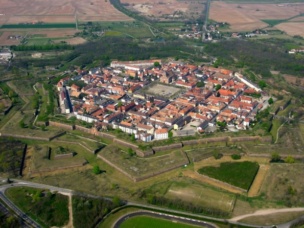
A bastion or bulwark is a structure projecting outward from the curtain wall of a fortification, most commonly angular in shape and positioned at the corners of the fort. The fully developed bastion consists of two faces and two flanks, with fire from the flanks being able to protect the curtain wall and the adjacent bastions. Compared with the medieval fortifications they replaced, bastion fortifications offered a greater degree of passive resistance and more scope for ranged defense in the age of gunpowder artillery. As military architecture, the bastion is one element in the style of fortification dominant from the mid 16th to mid 19th centuries.
Evolution
By the middle of the 15th century, artillery pieces had become powerful enough to make the traditional medieval round tower and curtain wall obsolete. This was exemplified by the campaigns of Charles VII of France who reduced the towns and castles held by the English during the latter stages of the Hundred Years War, and by the fall of Constantinople in 1453 to the large cannon of the Turkish army.
During the Eighty Years War (1568–1648) Dutch military engineers developed the concepts further by lengthening the faces and shortening the curtain walls of the bastions. The resulting construction was called a bolwerk. To augment this change they placed v-shaped outworks known as ravelins in front of the bastions and curtain walls to protect them from direct artillery fire.
These ideas were further developed and incorporated into the trace italienne forts by Sébastien Le Prestre de Vauban, that remained in use during the Napoleonic Wars.
Effectiveness
Bastions differ from medieval towers in a number of respects. Bastions are lower than towers and are normally of similar height to the adjacent curtain wall. The height of towers, although making them difficult to scale, also made them easy for artillery to destroy. A bastion would normally have a ditch in front, the opposite side of which would be built up above the natural level then slope away gradually. This glacis shielded most of the bastion from the attacker's cannon while the distance from the base of the ditch to the top of the bastion meant it was still difficult to scale.
In contrast to typical late medieval towers, bastions (apart from early examples) were flat sided rather than curved. This eliminated dead ground making it possible for the defenders to fire upon any point directly in front of the bastion.
Bastions also cover a larger area than most towers. This allows more cannons to be mounted and provided enough space for the crews to operate them.
Surviving examples of bastions are usually faced with masonry. Unlike the wall of a tower this was just a retaining wall; cannonballs were expected to pass through this and be absorbed by a greater thickness of hard-packed earth or rubble behind. The top of the bastion was exposed to enemy fire, and normally would not be faced with masonry as cannonballs hitting the surface would scatter lethal stone shards among the defenders.
If a bastion was successfully stormed, it could provide the attackers with a stronghold from which to launch further attacks. Some bastion designs attempted to minimise this problem. This could be achieved by the use of retrenchments in which a trench was dug across the rear (gorge) of the bastion, isolating it from the main rampart.
Types
Various kinds of bastions have been used throughout history.
-- Solid bastions are those that are filled up entirely, and have the ground even with the height of the rampart, without any empty space towards the centre.
-- Void or hollow bastions are those that have a rampart, or parapet, only around their flanks and faces, so that a void space is left towards the centre. The ground is so low, that if the rampart is taken, no retrenchment can be made in the centre, but what will lie under the fire of the besieged.
-- A flat bastion is one built in the middle of a curtain, or enclosed court, when the court is too large to be defended by the bastions at its extremes.
-- A cut bastion is that which has a re-entering angle at the point. It was sometimes also called bastion with a tenaille. Such bastions were used, when without such a structure, the angle would be too acute. The term cut bastion is also used for one that is cut off from the place by some ditch.
-- A composed bastion is when the two sides of the interior polygon are very unequal, which also makes the gorges unequal.
-- A regular bastion is that which has proportionate faces, flanks, and gorges.
-- A deformed or irregular bastion is one which lacks one of its demi-gorges; one side of the interior polygon being too short.
-- A demi-bastion has only one face and flank. To fortify the angle of a place that is too acute, they cut the point, and place two demi-bastions, which make a tenaille, or re-entry angle. Their chief use is before a hornwork or crownwork.
六、历史文化
Until the early Middle Ages the region around Weesp was an uninhabited peat bog. Weesp (Wesopa in Latin documents) was granted city rights in 1355 and celebrated its 650th anniversary as a town in 2005.
From the late Middle Ages, the river Vecht was a defensive line for the County of Holland and it remained a military defensive line until the Second World War. Weesp was strongly fortified, more than its size would justify; for most of its history it had a few thousand inhabitants.
The defensive lines consisted of inundation zones, which would be flooded in wartime (the Hollandic Water Line). Behind them were fortified towns, forts, barracks and other military structures. The most comprehensive was the Defence Line of Amsterdam (Stelling van Amsterdam), a circular inundation zone around Amsterdam, a UNESCO World Heritage Site.
After the Second World War, new housing was built in the west and an industrial zone with a harbour at the Amsterdam-Rhine Canal was constructed. In the 1970s a suburb was built on the south. Another suburb was built in the north which recently expanded with plans for further expansion.
Before the reformation the church was dedicated to Saint Laurens. It is still in use for Protestant services. In the tower it has a famous carillon by Pieter Hemony cast in 1671. Following the 19th Century emancipation of Dutch Catholics, a Catholic church was erected in Weesp.
七、其他信息
Population centres
The municipality of Weesp consists of three towns: De Horn, Uitermeer, and Weesp. The north of the town of Weesp is known for its Hogewey dementia village.
八、联系方式

Mayor Bas Jan van Bochove (acting) (CDA)
Bastiaan Jan van Bochove is a former Dutch politician and educator. As a member of the Christian Democratic Appeal he was an MP from 26 October 2010 to 19 September 2012. He focused on matters of housing, Kingdom relations and education. From 1990 to 2002 he was an alderman of Lelystad.
visiting address
Nieuwstraat 70a, 1381 BD Weesp
Tel: (0294) 491 391
Taxes tel: (020) 255 4800
E-mail: info@weesp.nl
Social media
Facebook: Municipality of Weesp @weespgemeente
Twitter: Gemeente Weesp @Weesp
https://www.weesp.nl
