Roermond 作者: 来源: 发布时间:2021-10-18
一、人口,面积,所属地区
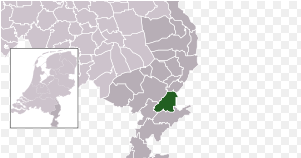
Location in Limburg
Coordinates: 51°12′N 5°59′E
Country Netherlands
Province Limburg
Area
• Total 71.10 km2 (27.45 sq mi)
• Land 60.84 km2 (23.49 sq mi)
• Water 10.26 km2 (3.96 sq mi)
Elevation 22 m (72 ft)
Population (January 2019)
• Total 58,209
• Density 957/km2 (2,480/sq mi)
Demonym(s) Roermondenaar
Roermond is a city, a municipality, and a diocese in the southeastern part of the Netherlands.
Roermond is an historically important town, on the lower Roer at the east bank of the Meuse river. It received town rights in 1231. Roermond town centre has been designated as a conservation area.
Through the centuries the town has filled the role of commercial centre, principal town in the duchy of Guelders and since 1559 it has served as the seat of the Roman Catholic Diocese of Roermond. The skyline of the historic town is dominated by the towers of its two churches: St. Christopher Cathedral and Roermond Minster or 'Munsterkerk' in Dutch. In addition to important churches, the town centre has many listed buildings and monuments.
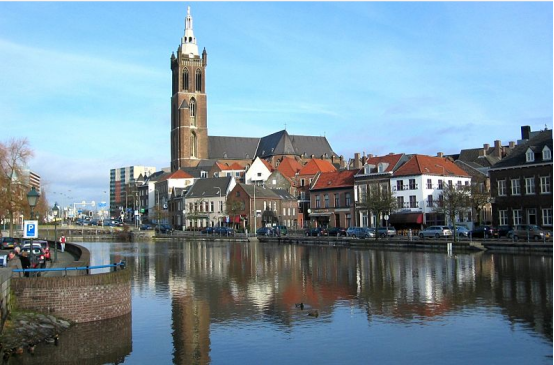
Roermond in 2011
二、自然地理
Roermond is situated in the middle of the province of Limburg bordered by the River Maas to the west and Germany to the east.
Population centres
The community of Roermond consists of the following population centres:
Roermond Maasniel Leeuwen
Asenray Herten Merum
Ool Swalmen (since 2007) Boukoul (since 2007)
Asselt (since 2007)
Nature and recreation
Roermond is encircled by a green belt, which offers many opportunities for hiking and cycling. To the east nature reserves, such as the Meinweg National Park, the valley of the Leu (Leudal) and the Swalm and Roer rivers, provide woodlands, heath and meadows. The Meinweg also contains a small amount of wildlife including a small group of vipers, the only venomous snake to live in the Netherlands. To the west the Meuse River and its lake area, known as "Maasplassen", offer opportunities for water recreation.
Floods
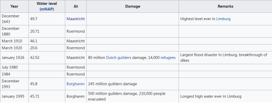
As a town near to and surrounded by water and close to two rivers, the Maas and the Roer, Roermond often has to defend itself against floods. The worst floods were in 1993 and 1995.
Infrastructure
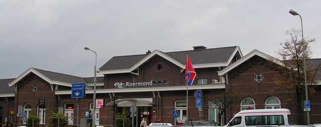
Roermond railway station in 2007
Access roads to Roermond have been upgraded recently, providing direct access to the Dutch and German highway network. From north to south the A73 (Maastricht-Nijmegen) passes east of the city, partly through tunnels. Eastwards the German A52 leads to Düsseldorf. Westbound the provincial road N280 leads towards Weert and connects to the A2 towards Eindhoven.
Roermond has a train station with quarter-hourly fast trains across the country to:
Southbound: Sittard-Maastricht-Heerlen
Northwestbound: Weert-Eindhoven onwards to Amsterdam.
In addition there are commutertrains with half-hourly service to:
Northeastbound: Venlo-Nijmegen
Southbound: Sittard-Maastricht
The municipality of Swalmen also has a railway station serving commuter trains on the line Roermond-Venlo twice hourly.
For regional transport there is a bus station with municipal and regional lines to nearby villages and towns. There used to be a bus service to Heinsberg in Germany, which was terminated in December 2008. There are no long-distance coach services.
三、经济发展和规模
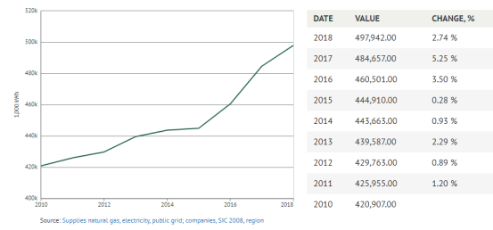
Total » Total » A-U All economic activities - Roermond - Electricity. delivered
497,942.00
1,000 kWh in 2018
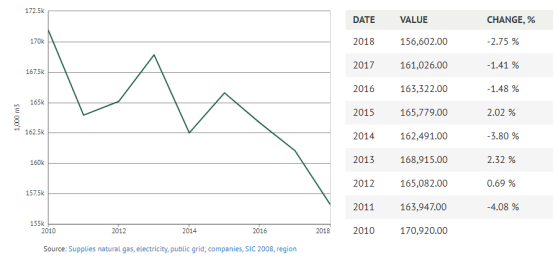
Total » Total » A-U All economic activities - Roermond - Natural gas, delivered
156,602.00
1,000 m3 in 2018
Reference: https://knoema.com/search?query=Roermond%20economy
Though Roermond grew and expanded steadily over the years to come it was not until the start of the 21st century that Roermond saw another boost coming. This recent growth was mainly caused by the construction of the highway A73 circling Roermond on the east-side. The highway was planned to open in January 2007 with the 2.5 km (1.6 mi) long Roertunnel leading traffic underneath a part of the city and the shorter Swalmertunnel underneath Swalmen. However, due to delays the tunnels only opened with 1 carriageway available and frequent closures. The tunnels grew infamous during the first weeks when numerous closures due to technical problems caused constant traffic jams. The tunnels are now fully operational. Another highway connection under construction is the German autobahn A52. The last 6 km (4 mi) stretch from Düsseldorf to the German-Dutch border was recently completed. The highway leads from Roermond straight to Düsseldorf.
Though the economy runs above average in the region and the town attracts new residents (mainly young people), the city itself still has a fairly high unemployment rate of 10.7% and the average income is lower than the national average.
四、产业特点/重点项目
Designer Outlet Roermond
Since 2001 Roermond is home to a McArthurGlen Designer Outlet, which has become one of the largest and most successful designer outlets in Europe with an average of almost six million customers per year, making it one of the biggest tourist attractions in the Netherlands. In 2017 it reached 200 shops following its latest expansion.
Projects
1, Urban Maasplassen Development Framework
Roermond has a unique location bordering the Maas, the Roer and the Roerplassen. This offers residents and visitors unprecedented recreational opportunities in a beautiful and healthy living environment. The puddles around the city of Roermond are not all the same. This development framework focuses on the urban Maasplassen, being the Noorderplas and the Zuidplas (Plas Hatenboer).
The Urban Maasplassen are a short distance from the old city center of Roermond and the Designer Outlet Center. They offer a large number of options for water recreation. To utilize the potential of the Noorderplas and the Zuidplas in the right way, the municipality of Roermond needs a development framework for the Urban Maasplassen. This development framework has been established as a policy rule.
Using a development framework, the municipality can determine which developments and facilities are desirable and possible in the Urban Maasplassen. In addition, the use of a development framework creates more structure and cohesion in the area because the nature and size of (new) facilities are coordinated and the relationship with the rest of the city is strengthened. In this way, the potential of the Urban Maasplassen is better utilized, the relationship with (the city center of) Roermond can be improved and, at the same time, the existing landscape, ecological and recreational qualities of the area are maintained and strengthened.
The development framework (PDF, 8 MB) was coordinated with many different stakeholders, such as the Province of Limburg, Rijkswaterstaat, Limburg Water Board, residents, entrepreneurs, water sports associations and the Roermond Nature and Environment Organizations (RNMO).
For more information, please contact Tom Hölsgens, planner of the municipality of Roermond via e-mail address: tomholsgens@roermond.nl
2, Major maintenance Swalmen
The municipality carries out district-oriented maintenance in the Groene Kruisbuurt in Swalmen.
Groene Kruisbuurt
The order for the activities in the Groenekruisbuurt has been awarded to Strabag BV in Herten. From Monday 4 May, Strabag will start major repairs with phase 1:
Schoolstraat, Hazards, Meestersweg and Schutterskamp. In this phase we close the Dangers / Masters road. We indicate the diversion route on location. During the upcoming work we will replace the existing sewer, drains and house connections. In addition, we carry out major maintenance on roadways, sidewalks, parking lots and traffic and green areas.
Schedule
Strabag will carry out the work in 6 phases, see the phasing schedule (Pdf, 1.1 MB) in which we mainly work in two work areas at the same time.
Contact
For each phase, residents and entrepreneurs in the relevant work area receive a residents letter with the specific information, planning, parking and possible diversions.
Because of the Coronavirus, the walk-in office hours on location are canceled. You can also contact us at:
www.facebook.com/goswalmen
STRABAG Environment app
Email NL-swalmen@strabag.com
There is no general information evening regarding the Corona virus. Instead , you can find the presentation here (PDF, 3 MB) or watch it on YouTube
3,Roermond is working on the station and surroundings!
In the coming years, the municipality of Roermond will be working on the station environment. Together with the province of Limburg, NS, ProRail, Arriva and other parties involved, we are making the station area a beautiful regional mobility hub. Buses, trains and other transport fit together well. The station is easily accessible for everyone and lots of greenery, extra space and sustainable lighting, make it pleasant to be there. The regional mobility hub will be a calling card for the city and the region
Images of the approach to the bus station in the period April - mid July 2020 (YouTube)
https://www.youtube.com/watch?v=_uFBVm0D3mo&feature=youtu.be
Planning work station environment
Below we list the activities in the station environment until the end of 2020.
For bicycle and moped riders
You can park your bicycle for free for the first 24 hours in the guarded garage at the station. For more information, visit www.jefietswilnooitmeeranders.nl .
Cyclists can also park their bicycles in the temporary outdoor parking facility in the Veeladingstaat. There is also an outdoor parking for moped riders.
The outdoor parking facility that lay between the trusted bus station and the NS station is no longer used. You are also still not allowed to park your bicycle on the Stationsplein. Removed bicycles are located at Stadstoezicht, Slachthuisstraat 102 in Roermond. You can pick up your bike after making an appointment by phone. The telephone number is: 0475-359101.
For motorists
The temporary bicycle and moped parking and temporary bus station are now located in the Veeladingstraat. That is why the P + R site is closed to motorists. The alternative parking option is the P + R site at the Godswerdersingel.
The Stationsplein can still be used by taxis or to drop someone off or pick them up quickly. A number of parking spaces have been kept free for loading and unloading from the hotel and the florist.
For bus passengers
The bus station will be renovated until August 30, 2020. The bus station is therefore temporarily located in the Veeladingstraat (former P + R site). Information can be found on signs at the station, at www.arriva.nl , in the Arriva travel planner and on screens in buses. Take an extra few minutes into account, between bus stop and station.
Diversion bus routes
Because the bus station is located in the Veeladingstraat until 30 August 2020, travelers have to take extra travel time into account. This is due to the adapted routes of the buses and the aforementioned extra minutes running time between bus stop and station. Consult the Arriva travel planner before you leave.
Bus lines 1, 62, 63, 64, 66 and 794 will run a different route from May 6 to August 30. The Nassaustraat stop on Bredeweg can be used as a temporary stop. See the roadmap below. Travelers on bus lines 63 and 64 from Heinsberg and Posterholt to the hospital must transfer to bus lines 1, 62, 63, 64, 66 or 794 at the temporary bus station.
View the diversion routes for bus lines (PDF, 1.24 MB)
Temporary routes and facilities
The temporary bus station is located in the Veeladingstaat. When you come out of the station, turn immediately left. The guarded bicycle shed of the NS and the temporary outdoor sheds for bicycles and mopeds are also located in that street. The walking routes to the center, the bus and train station and the stables are indicated on signs. Coming from the center, all station facilities are accessible via the Stationsplein.
Information for local residents
Construction of the new bus station at Roermond Station is currently in full swing. The concrete of the bus square has been poured, which means that contractor Den Ouden is now starting to cut. Cutting means that the concrete is cut to prevent cracks. This should be done at a special time, the concrete should not be too soft, but also not too hard. Since the drying of the concrete depends, among other things, on the weather, we cannot predict exactly when to cut. The period in which these activities may take place is from Monday 6 July (calendar week 28) to calendar week 34.
It is possible to cut outside the agreed working hours (weekdays from 7:00 am to 11:00 pm and on weekends from 9:00 am to 11:00 pm). When that happens, Den Ouden reports this in an app group for local residents who have also been informed about this by letter. You can register for this app group with Robin van Dongen, environment manager at Den Ouden. His email address is r.vandongen@denoudengroep.com . Report your mobile phone number in this email so that you can be added. Of course we are fully committed to prevent nuisance as much as possible.
Information and contact
Do you have questions about the construction work? Send an email to: station@roermond.nl . You can also call us: 14 0475 (Customer Contact Center, Municipality of Roermond).
You can also follow us on Facebook: www.facebook.com/gemeenteroermond .
五、风景名胜,景点
Roermond's old town centre is home to several historic monuments, including:
Cuypershuis
Munsterkerk
Stateroom of city hall
The old cemetery
Kapel in 't Zand
Roermond City Hall
St. Christopher Cathedral
Carolus chapel
National Indiëmonument
Kasteeltje Hattem
Rattentoren
The Galgeberg is a small hill in Roermond. It is in the Kapel in 't Zand-area of Roermond. "Galgeberg" is Dutch for "gallows hill". Once criminals were hanged or burned here. In 1613, 64 witches were burned here; it was the biggest witch trial in Dutch history.
1, Munsterkerk
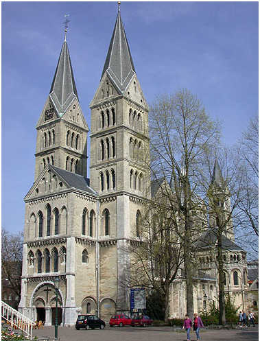
Munsterkerk in 2005
The Munsterkerk (Munster) is a 13th-century church dedicated to Our Lady in the Dutch town of Roermond. Its remarkable front towers are 55 meter in height. The Munsterkerk is one of the most important example of Late Romanesque architecture in the Netherlands. The Roermond Minster is the only surviving part of an abbey, the rest of which was demolished in 1924. The church was renovated by architect P. J. H. Cuypers between 1863 and 1890; during this renovation the two front towers were added while after a smaller baroque bell tower on the nave was removed, and the originally octagonal eastern towers were replaced by square ones. The renovation of the Roermond Minster was highly controversial, but Cuypers continued to renovate the Minster according to his plan.
In 1992, the church was damaged by an earthquake which destroyed the two eastern towers, which were rebuilt shortly after.
The church is a Rijksmonument, and is part of the Top 100 Dutch heritage sites.
Burials
Richardis of Bavaria
Gerard III, Count of Guelders
his wife, Margaretha of Brabant
2, St. Christopher's Cathedral, Roermond
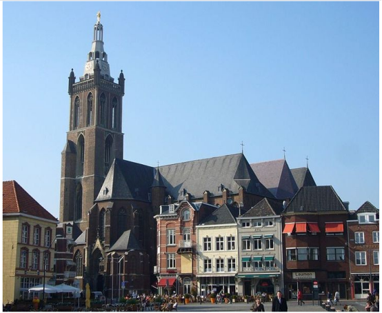
The cathedral, as seen from the market place
St. Christopher's Cathedral in the Dutch city of Roermond is the main church of the Roman Catholic Diocese of Roermond. It is dedicated to Saint Christopher.
Location
The cathedral is located on the market square, near the river Meuse and a Meuse fortress, on a pedestrian underpass leading to the outlet Centre.
History
The construction of the Christoffelkerk, which began in 1410 and was initially designed as a basilica on a cruciform ground plan, was intended to replace an older parish church outside the walls of the town of Roermond. During the 15th century the building plans were changed; the choir was completed as a three-aisled hall, the nave was built with five naves. The building was completed in the course of the 16th century. In 1661 the church was elevated to the status of bishop's church of the Roman Catholic Diocese of Roermond, established in 1559.
In World War II the church suffered heavy damage when German troops blew up the 78-metre-high tower built into the western part of the nave on the day before the liberation of the town by Allied troops. The tower has been restored to its old form after the war. The earthquake in the Roermond area in 1992 caused further damage. A new, comprehensive renovation took place in the years 2005 to 2007.
六、历史文化
Where before Celtic inhabitants of this region used to live on both sides of the Roer river, invading Romans built a bridge (now called the Steene Brök, or stone bridge) and founded the first town at Roermond, now a suburb called Voorstad Sint Jacob.
Guelders
Around 1180–1543, Roermond belonged to the duchy of Guelders. In 1213 Roermond was destroyed by Otto IV of Brunswick, the Holy Roman Emperor and German King. By 1232 the town had been rebuilt, and was given its own seal, own reign, own mint, and its own court.
The first mention of the monastery of the Franciscan Friars Minor, the Minderbroederklooster, was in 1309. In 1361, the Chapter of the Holy Spirit moved from Sint Odiliënberg to Roermond.
Around 1350, Roermond became the capital of the "Overkwartier van Gelre" (Upper Quarter of Gelre). In 1388, during the Hundred Years' War, it was besiegec by the French. A battle for the outer fortifications Buiten Op, destruction of these fortifications and the old parish church followed.
In 1441, Roermond became a member of the Hanseatic League, and by 1472 acquired the right to mint its own coins.
Spanish Netherlands
Between 1543–1702 the area was part of the Spanish Netherlands.
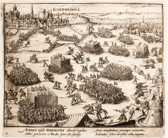
Attack on Spanish Roermond by William the Silent in 1572
On 23 April 1568 the Battle of Rheindalen occurred near Roermond, which signaled the start of the Eighty Years' War. In 1572, Roermond was occupied by the Dutch William the Silent, but recaptured by the Spanish duke Fadrique Álvarez de Toledo
Under Spanish rule Roermond became a bastion of the Counter-Reformation. On behalf of the Inquisition people were encouraged to report suspects of witchcraft and heresy. In 1613, 64 witches were burnt on the Galgeberg hill near the Kapel in het Zand in Roermond, the biggest witch trial in the Netherlands ever.
In 1632 the Dutch Stadhouder Frederik Hendrik conquered Venlo, Roermond and Maastricht during his famous "March along the Meuse". Attempts in the next years to annex Antwerp and Brussels failed, however. The northern Dutch were disappointed by the lack of local support. The Counter-Reformation had firmly reattached the local population to Roman Catholicism, and they now distrusted the Calvinist Northerners even more than they loathed the Spanish occupiers.
Between 1632 and 1637, Roermond was under the control of the Dutch Republic, and again from 1702 to 1716. Between 1716 and 1794, it was part of the Austrian Netherlands within the Habsburg Monarchy.
French Period
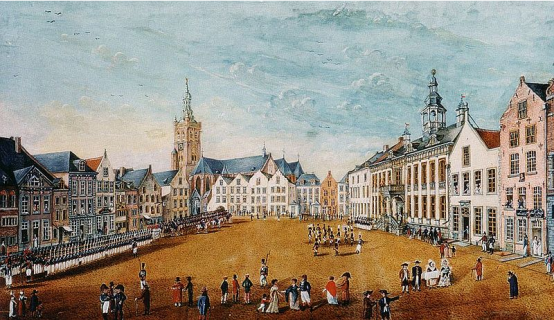
French troops in Roermond, 1793
On 11 December 1792, during the French Revolutionary Wars, the French under General De Miranda conquered Roermond, but by 5 March 1793, was under Habsburg control again. The city was again occupied by the French on 5 April 1794 and officially became part of the French département Meuse-Inférieure from 1795 to 1814. In 1814, during the War of the Sixth Coalition Roermond was liberated by the Russians.
Kingdom of the Netherlands
After the Anglo-Dutch Treaty of 1814 Roermond became part of the new Kingdom of the Netherlands. The new province was to receive the name "Maastricht", after its capital. King William, who did not want the name Limburg to be lost, insisted that the name be changed to Limburg. As such, the name of the new province derived from the old duchy of Limburg that had existed until 1648 within the triangle Maastricht – Liège – Aachen.
When the Netherlands and Belgium separated in 1830, there was support for adding Limburg to Belgium, but in the end (1839) the province was divided in two, with the eastern part going to the Netherlands and the western part to Belgium. From that time, Dutch Limburg was, as the new Duchy of Limburg, also part of the German Confederation.
Between 1940 and 1945, during World War II, the Germans occupied Roermond. The town was liberated on 1 March 1945 by the Recce Troop of the 35th US Infantry Division during Operation Grenade. By the time of liberation 90% of all buildings were either damaged or destroyed. Restoration returned the old town centre to its full glory.
On 1 May 1988 the Provisional Irish Republican Army (IRA) killed three British airmen and injured three others in a double attack. IRA members opened fire on a car in Roermond with Royal Air Force airmen, killing Ian Shinner. Half an hour later, a second attack elsewhere, in Nieuw-Bergen, killed two British airmen and injured another.
In a separate attack two years later two Australian nationals were killed. The two men were lawyers on holiday, whom the IRA shot believing they were off-duty British Army soldiers. Australian Prime Minister Bob Hawke denounced the IRA explanation saying 'This sort of warped logic of war casualties adds insult to a mortal injury,'[5] and a later Prime Minister John Howard refused to meet Gerry Adams from Sinn Féin on a visit to Australia in 2000.
On 13 April 1992, a magnitude 5.4 earthquake occurred near the town of Roermond at a focal depth of about 17 km (11 mi). This so-called Roermond earthquake was the strongest seismic event in Western Europe since 1756. Following this earthquake, the water levels of numerous wells located in the Lower Rhine Embayment showed significant coseismic anomalies. The Roer Valley, which crosses three countries (Belgium, The Netherlands, and Germany), is bounded by two north-northwest, south-southeast trending Quaternary normal fault systems. The eastern boundary is defined by the Peel boundary fault, along which the 1992 Roermond earthquake occurred,[6] and the western boundary is defined by the Feldbiss fault zone, which is partly located in Belgium. Evidence of recent tectonic activity along the Feldbiss fault zone is visible on seismic profiles that show more than 600 m of offset in Neogene deposits.[7] Although Ahorner demonstrated the existence of the Rhenish seismoactive zones and recommended a comprehensive analysis of Quaternary structures and background seismicity, coseismic movements were considered to be improbable and active faults remain largely unidentified.
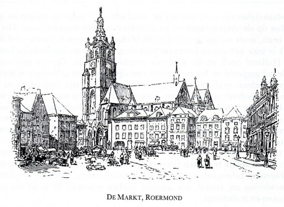
Marketplace in Roermond (Pictures from Holland 1887) by Richard Lovett

Roermond in 1945 with the heavily damaged St. Christopher's Cathedral in the background
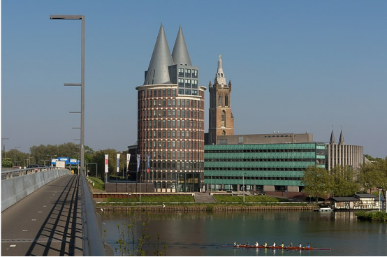
The Natalini tower and the cathedrale in the background
七、其他信息
Crime
In 2006, Roermond was ranked as the third most criminal place in the Netherlands,[10] outscoring Amsterdam. In 2007, Roermond managed to improve its reputation, dropping to 9th place (though this figure is combined with the district of Swalmen, which had its own score in 2006). Efforts are being put in place to limit petty crime (especially car break-ins and house burglaries). In 2013, Roermond was in 13th place.
Culture
Events
Roermond hosts several festivals, including a Liberation Day festival on 5 May and the dance festival Solar Weekend.
Anthem
Roermond has had its own anthem since 1912. The text was written by A. F. van Beurden, the music is by H. Tijssen, who also composed the Limburg Anthem (Waar in 't bronsgroen eikenhout).
In everyday life in Limburg around 1900 the Dutch language was of less importance. Everything was done in Limburgs. Newspapers in the 19th century were sometimes written in German, and in some parts of Limburg German was the language used in church and education. In this time Maastricht still had a very strong connection with French-speaking areas around Liège. Van Beurden's poem was used to force the people of Limburg into speaking Dutch. Proof of this is the very un-Limburg part in the anthem, the reference to the Dutch Royal family. In 1900 the people in Limburg had to swear their allegiance to the Dutch royal family of the House of Orange-Nassau in a "aanhankelijkheidsverklaring aan het Oranjehuis" and had to start using Dutch instead of Limburgs.
八、联系方式

Mayor Rianne Donders-de Leest (CDA)
Twitter: Rianne Donders @RianneDonders
M.J.D. "Rianne" Donders-de Leest (born 22 July 1960 in Eindhoven) is a Dutch politician for the Christian Democratic Appeal (CDA).
Donders-de Leest started her career as a teacher at a primary school. She was elected into the municipal council of Etten-Leur in 1990. Till 2002 she was a councillor, among others as leader of the CDA fraction. In 2000 she also became an alderman, dealing with spatial planning, traffic, transportation, housing and sports.
From 1 September 2004 to 9 January 2015 she was mayor of the municipality of Geldrop-Mierlo. Since 30 January 2015 she has been mayor of Roermond.
visiting address: Kazerneplein 7, 6041 TG Roermond
tel: 14 0475
WhatsApp: 06-10465487
Mailing address: PO Box 900, 6040 AX Roermond
Website: https://www.roermond.nl/ondernemer
Twitter: Gemeente Roermond @roermondnieuws
Facebook: Gemeente Roermond @gemeenteroermond
