Utsjoki Village 作者: 来源: 发布时间:2021-10-15
一、所属省或是州,具体位置,人口,面积
Utsjoki is a municipality in Finland, the northernmost in the country. It is in Lapland and borders Norway as well as the municipality of Inari. The municipality was founded in 1876. It has a population of 1,235 (31 January 2019) and covers an area of 5,372.00 square kilometres (2,074.14 sq mi) of which 227.51 km2 (87.84 sq mi) is water. The population density is 0.24 inhabitants per square kilometre (0.62/sq mi). Utsjoki has two official languages: Finnish and Northern Sami. It is the municipality in Finland with the largest portion of Sami speakers; 46.6% of the population.
The Nature reserve Kevo is in the municipality. It covers a territory of 712 km2 (275 sq mi) and there is a 63 km (39 mi) long hiking trail. The trail partly follows the edge of the Kevo canyon. The "midnight sun" is above the horizon from 17 May to 28 July (73 days), and the period with continuous night lasts a bit shorter, polar night from 26 November to 15 January (51 days). The topography of Utsjoki is dominated by two larger rivers: the Tenojoki, together with its Inarijoki tributary, forms the border with Norway. The eponymous river Utsjoki flows north-south through the municipal area before it flows into the Tenojoki. Utsjoki's settlement is entirely concentrated in the valleys of these two rivers. The areas of the community away from the two rivers are completely pathless and uninhabited. The nature here is very barren due to the extreme northern location. Pine trees only grow in isolated areas, otherwise the only tree species found in Utsjoki is birch. The tree line is already reached at an altitude of 300 meters above sea level, in higher altitudes there is tundra-like vegetation.
Much of Utsjoki's area is protected. In the area of the municipality are the wilderness areas Kaldoaivi, Muotkatunturi and Paistunturi as well as the 712 km² large Kevo nature park. The Kevojoki River flows through a canyon up to 80 m deep over a distance of 40 km.
202.93 km², which is less than 4% of the municipal area, is covered by water. As in general in Lapland, the share of inland water is well below the national average of Finland. The number of lakes is relatively high with around 600 lakes with a size of over five hectares and about 300 smaller ponds, but they are all rather small. The largest lakes are the Pulmankijärvi (12 km²) south of Nuorgam on the border with Norway and the Luomusjärvi in the Kevo Nature Park.
www.utsjoki.fi
二、自然地理
1.地理条件
The Utsjoki Village is located at Northern Lapland of Finland. Utsjoki is located in the far north of Finland in the Lapland countryside on the border with Norway. At the village of Nuorgam is the northernmost point of Finland and the European Union. The district of Utsjoki is quite extensive: With 5,372 km², Utsjoki is more than twice the area of Saarland or Luxembourg. Much of the municipal area consists of uninhabited wilderness. With 1232 inhabitants, this results in a population density of 0.24 inhabitants per square kilometer of land.
Neighboring municipalities of Utsjoki are Inari in the south and on the Norwegian side Karasjok in the west, Tana in the north and Nesseby in the northeast. The distance to Rovaniemi, the capital of Lapland, is 453 km; Helsinki is 1267 km away.
Due to the extremely low population density, large parts of Utsjoki are pathless, but since the 1970s all settlements have been accessible by road. The largest traffic artery is the state road 4, the most important north-south connection of Finland, which comes from Inari from southern Finland in a north-south direction through Utsjoki to the Norwegian border at the church village of Utsjoki. The main road 92 branches off from the state road 4 in Kaamanen in the municipality Inari and leads to the village Karigasniemi in Utsjoki. Regional road 970 follows the right bank of Tenojoki and leads from Nuorgam via Utsjoki to Karigasniemi. It continues as a dirt road 9704 to the village of Angeli in the municipality of Inari. The smaller road 19999 leads from Nuorgam to Lake Pulmankijärvi. In Utsjoki there are three border crossing points to Norway: In Utsjoki, the Saamen-silta bridge, built in 1993, leads over the Tenojoki to the opposite Norwegian bank, where Europastrasse 75 continues. Karigasniemi is also connected to the Norwegian Karasjok by a bridge over the Tenojoki. In Nuorgam there is a border crossing to Polmak in Norway.
Utsjoki was connected to the road network very late. Previously, the settlements were only accessible by boat via the Tenojoki, with the boats sometimes having to be transported past rapids. In winter, the frozen Tenjoki could also be driven by car. The first road connection from Kaamanen to Karigasniemi was established during the Second World War, the road from Kaamanen to Utsjoki was opened in 1957. Originally, the section from Kaamanen to Karigasniemi formed the final section of state road 4, only after completion of the Saamen-silta bridge in 1993 was state road 4 diverted to Utsjoki and the Kaamanen-Karigasniemi route converted into main road 92. Nuorgam was the last settlement to be connected to the road network only in 1971. In 1983 the cross connection from Karigasniemi to Utsjoki was finally established.
From Ivalo there are bus connections via Utsjoki to Nuorgam and to Karigasniemi. Buses to Norway run from Karigasniemi to Karasjok and from Nuorgam to Tana. Utsjoki is not connected to the railway network, the nearest train stations are Kolari 386 km southwest and Rovaniemi 453 km south. The nearest airports are in Lakselv, Vadsø and Kirkenes in Norway and on the Finnish side in Ivalo.
www.utsjoki.fi
2. 交通情况
Utsjoki is at the northern end of highway 4, the longest highway in Finland. The European route E75 runs along the Sami Bridge further to Norway.
www.utsjoki.fi
三、经济发展和规模
The Municipal tax rate in Utsjoki Village is around 20.75%.
Like the rest of Lapland, Utsjoki's main economic activity is in the service sector. In total, 76.1% of the workforce works in the tertiary sector, both in public and private services. In fact, the main source of income for the municipality is the fishing tourism that the Teno River attracts and the trade that the border brings. On the other hand, it is worth mentioning the role of livestock among the Sami, as reindeer herding is an important feature of their culture. 10.6% of primary sector workers. The unemployment rate is the fifth lowest in the region: 8.6% (2020) [64]; and the municipal rate is 21%.
www.utsjoki.fi
四、产业特点/重点项目
The Tenojoki is one of the most salmon-rich rivers in Europe and therefore attracts many fishing tourists to the area. Day trips by Norwegians who shop in the cheaper neighboring country of Finland are also very important. In addition to tourism, reindeer herding, which is often still semi-nomadic, is one of the main branches of the economy.
Until the middle of the twentieth century, Utsjoki was a primary sector municipality. Sami reindeer farms were the main source of income for the population, and fishing and climate-conditioned agriculture made up these gains. However, the situation began to change in the 1950s. Although the popularity of salmon in the Teno River has long been known, more and more fishermen came to Utsjoki, and services began to be developed around this activity. In the hands of fishing tourism, shops were opened, hotels, roads, restaurants, and fishermen from all over the country revived the economy of the municipality. Along with this prosperity, a large number of Finnish citizens arrived, and the predominance of the Sami in the population was reduced. Within a few years, Utsjoki's economic structure changed dramatically and it became a third-sector municipality.
Fishermen on the Teno River near Boratbokca (2015).
On the other hand, Norwegians who cross the Teno River and come to the town to shop also play an important role in the economy of Utsjoki. When Finland became a European Union country in 1995, the economic situation in Norway and Finland changed. Although the two countries joined the Schengen area in 1996, when the euro arrived in 2002, product prices fluctuated sharply. Since then, Norwegians who cross the border and shop cheaper in Utsjoki shops leave a large amount of money in the municipality. The most profitable company is Alko, a company with shops in Nuorgam and Karigasniemi.
www.utsjoki.fi
五、风景名胜,景点( attractions)
1. Kevo Strict Nature Reserve
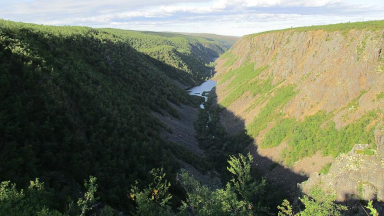
In Kevo Strict Nature Reserve, you can experience the Lapland landscape at its most wondrous. There are two marked trails, along which hikers may explore the area. Both trails are quite demanding.
The 40-km-long and at some places almost 80-metres-deep canyon-like valley of the River Kevojoki forms the core of the area. The rest of the nature reserve is fell highland crossed by gentle slopes of ravines. There are also large tundra-like open mires.
https://fi.wikipedia.org/wiki/Utsjoki
www.utsjoki.fi
2. Utsjoki Church Huts
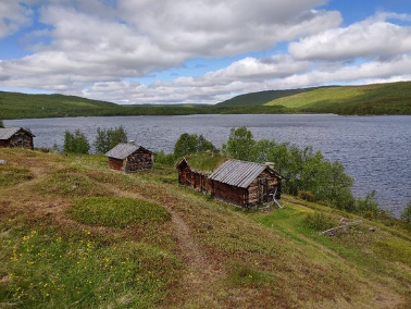
Alongside Lake Mantojärvi in Utsjoki there is a historical church hut area where, during the most active period in the 1930s, there were about twenty huts. There are thirteen buildings visible today. There have been church huts by the lake since the end of the eighteenth century, and probably even earlier, as the commune hut and the bailiff ’s hut near the present parsonage are mentioned already in documents dating from 1725. Two hundred metres south from the parsonage, between the lake and the church of St. Ulrika, there have also been dwellings. Historical sources and archaeological findings suggest that there has been some activity around the area since the end of the seventeenth century at the latest.
www.utsjoki.fi
3. Utsjoki Nature Information Hut
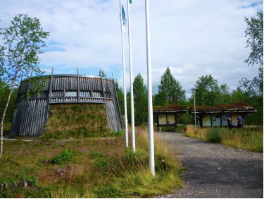
Utsjoki Nature Information Hut is located in Utsjoki. The Nature Information Hut offers tips on hiking in Utsjoki region: in Kevo Strict Nature Reserve and in wilderness areas nearby and also information on the River Tenojoki, which is known for its salmon.
www.utsjoki.fi
4. Utsjoen Kirkko
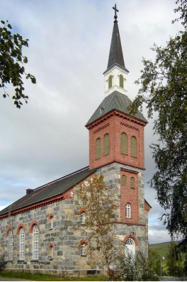
Utsjoki Church is a church in the Lapland town of Utsjoki. It is the northernmost church in Finland as well as in the European Union. The church was designed by the architecture office of Ernst Lohrmann and was built with grey stones during the years 1850–1853. The small church seats 230 people within its 170 square metres.
www.utsjoki.fi
5. Sámi Bridge
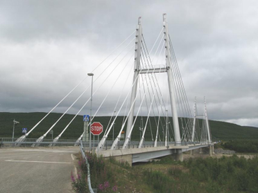
The Sami Bridge (Finnish: Saamen silta; Northern Sami: Sámi šaldi; Norwegian: Samelandsbrua) is a cable-stayed bridge that carries the European route E75 across the Tana River between Troms og Finnmark county in Norway and Utsjoki in Finland. The bridge is 316 metres (1,037 ft) long, and the main span is 155 m (509 ft). The Sami Bridge was opened in 1993.
www.utsjoki.fi
六、历史文化
1.历史
In addition to the cultural landscape of Mantojärvi, old buildings have been preserved in some other places in Utsjoki. These include old fishing huts from the 19th century on the river island of Lohisaari in Tenojoki, the former Sami winter village of Talvadas on the banks of the Tenojoki, and the ensemble of buildings by Mieraslompolo on the Utsjoki River and Välimaa on Tenojoki.
On the banks of the Tenojoki between Utsjoki and Nuorgam there is an old gravel road from Nivajoki to Alajalve. It was originally used to transport boats past the impassable Alaköngäs rapids of the Tenojoki. In 1928, the six-kilometer route was integrated into the public road network, although it was not connected to the rest of the road network. After the completion of the road connection to Nuorgam, the parallel old street was converted into a museum street. A second museum street can be found on the banks of the Utsjoki River. It is also a six-kilometer section of the historic postal route to Utsjoki.
www.utsjoki.fi
2. 文化
The valley of the Utsjoki River is officially one of the Finnish "national landscapes". In addition to its scenic beauty, the river valley owes this to a cultural and historical ensemble that has been preserved on the banks of Lake Mantojärvi, through which the Utsjoki River flows, six kilometers south of the community center. The church of Utsjoki stands on a small hill above the lake. The granite building was built in 1850-1853 according to plans by Ernst Lohrmann. The wooden predecessor was demolished after the completion of the new church, from which only the timbered sacristy from 1776 is preserved. Opposite the church on the banks of the Mantojärvi are 14 historic parlors. The wooden buildings date from the early 19th century and were used to accommodate well-traveled church visitors until the 1930s. Also close to the church is the representative rectory, which was designed in 1843 by Carl Ludwig Engel in the style of classicism. Connected are a few falcon red farm buildings, the oldest of which date from the 18th century.
www.utsjoki.fi
七、其他信息
Between the Teno and the Utsjoki river, there is an old hotel very popular with Norwegians and Finns alike, that was built by the Finnish Tourist Association in 1959. The outside look is still the same, but the rooms have been renovated and the hotel is now named Hotel Luossajohka.
The border to Norway follows the river Teno which flows into the Arctic Sea. The river is a popular site for recreational fishing because it is rich in salmon. The northernmost village in Finland and in the European Union is Nuorgam which is also the northernmost land border crossing in the world.
www.utsjoki.fi
八、联系方式
Governmental Municipal Manager:Vuokko Tieva-Niittyvuopio
Website: https://www.utsjoki.fi/
Phone number: 040 188 6111
Email: kunnanvirasto@utsjoki.fi
Address: PL 41, 99981 Utsjoki
