Kangasala 作者: 来源: 发布时间:2021-10-15
一、所属省或是州,具体位置,人口,面积
Kangasala is a city in Finland, 16 kilometers east of Tampere. It was founded in 1865. The city has a population of 31,743 (31 January 2019) and covers an area of 870.86 square kilometres (336.24 sq mi) of which 212.83 km2 (82.17 sq mi) is water. The population density is 48.24 inhabitants per square kilometre (124.9/sq mi).
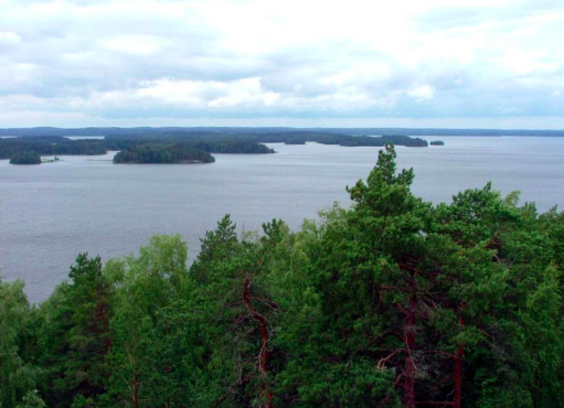
It is known in Finland for the beauty of its natural environment, as described by Zacharias Topelius in his poem "A Summer's Day in Kangasala" (which was later set to music by Gabriel Linsén). It is also known for its mansions, such as Liuksiala, where the Swedish queen Karin Månsdotterlived as widow, and Wääksy. Kangasala has a long history of tourism. The lakes Roine, Längelmävesi and Vesijärvi are located in Kangasala. They are mentioned in the poem by Topelius, and Vesijärvi is the lake where the scenic view described in the lyrics is situated. The municipality of Sahalahti was consolidated into Kangasala on 1 January 2005, and the municipality of Kuhmalahti on 1 January 2011.
二、自然地理
1.地理条件
The area is part of the municipality's city center. For a long time, the south side of the church was a workshop and warehouse area, which began to develop with the construction of Tampereentie and Ellintie in the 1970s and 1980s.
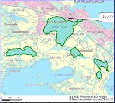
The zoning area and the interchange at its level are the most important entrance to the center of Kangasala. The environment of Tampereentie has developed rapidly, and according to the plans that are being realized, it will become even more urban. The formula area is located between the cultural landscape of the nationally valuable Kangasala church village and the internationally valuable bird water of Lake Kirkkojärvi. The regionally valuable landscape area of Luksiala-Tiihala is also affected by the formula.
https://www.kangasala.fi/wp-content/uploads/2019/02/820_kaavaselostus.pdf
2.交通情况
Highway 12 runs from Tampere to Lahti through Kangasala and from the center. Highway 9 (Tampere-Jyväskylä) runs through the northern part of Kangasala. The former route of Highway 9 from Huutijärvi to Orivesi is now part of Highway 58. In addition, regional road 310 to Valkeakoski and regional road 325 via Sahalahti and Kuhmalahti to Kuhmoinen depart from Kangasala.
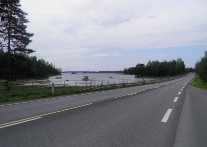
Huutijärvi became one of the most important road junctions inland hundreds of years ago; the road between Häme and Ostrobothnia that followed the ridge period and the so-called Vanha Laukaantie, which ran from the direction between Längelmävesi and Vesijärvi in the direction of Central Finland, merged. The road connection from Kangasala via the hinterland to Lempäälä also certainly dates back to before the Great Hate; instead, the road west of Roine to Valkeakoski was not completed until 1935. Especially after the Second World War, traffic volumes increased to such an extent that the church village of Kangasala became particularly accident-prone. The regional road from Huutijärvi to Kuhmois was completed in the late 1950s, and the Pelisalmi bridge over the Längelmävesi, built on the road, was the largest in the Häme road district when completed. At that time, the Majaalahti corner on the east side of Längelmävesi was the last to be covered by road traffic. The bypass south of the church village was completed in the mid-1970s; at the same time, a new road connection was completed from Tampere to Orivesi north of Kangasala. Highway 3, which originally ran through Kangasala on the same route as Highway 12, had already been moved through Sääksmäki in the early 1960s.
The Tampere-Orivesi railway line, which was opened to traffic in 1883, also passes through Kangasala. At one time, train traffic was significant for the municipality, but today trains do not stop in Kangasala due to the remoteness of the station. Direct bus connections from Kangasala to Tampere displaced the rather awkward train connection and the station area never became a significant population center. Freight traffic at Kangasala station was stopped in 1976, the station was closed in the spring of 1993 and the population in the agglomeration surrounding the station has also decreased. Today, the nearest passenger railway station in Kangasala is Tampere railway station. Other railway traffic locations in the Kangasala area were the Ruutana and Suinula stations and the Jussila stop between the Kangasala and Ruutana stations. These were all abolished in the late 1980s. The nearest airport to Kangasala is Tampere-Pirkkala Airport, which is about 33 km from the center of Kangasala.
三、经济发展和规模
The economic structure of Kangasala is close to the national average. 64% of the municipality's jobs are in the service sector, 30% in processing (22% in industry and 8% in construction) and 4% in agriculture and forestry (data from 2000). The unemployment rate has been around 12% in the early 2000s.
https://www.businesskangasala.fi/wp-content/uploads/2020/07/Vuosikertomus-2019-Business-Kangasala-Oy_2.pdf
四、产业特点/重点项目
Of the new business areas, Lamminrahka is located right on the border of the city of Tampere. The new interchange to be built in the area has already been completed and the high-profile business area rising along the 12-way road is located in the best Parade Ground on both sides of the junction. Lamminrahka-Ojala is one of the most significant regional development projects in the Tampere metropolitan area. A central business center area, the Lamminrahka-Ojala school and apartments for 8,000 inhabitants will be built in the area.
The Saaremaa business district will be located in the immediate vicinity of Tampere's Rusko business district. The area will form a network formed by the proximity of the University of Tampere and companies already located in Rusko, where it is easy for companies benefiting from high know-how and research knowledge to operate. The transport connections in the area are excellent thanks to the ring road II that will be built in the future. An operating environment corresponding to future business needs is being built in the Saaremaa region, where it is profitable to invest well into the future.
At the heart of the Tarastenjärvi area are the recycling of material flows and the circular economy. The Tarastenjärvi business area is located in the immediate vicinity of the waste treatment area and there is a connection to the utility power plant. Space has also been reserved for bioenergy producers and other activities for which a central logistical location is important. There are companies on both sides of Highway 9 that want positioning centrally and sustainably.
https://www.businesskangasala.fi/tontit/
五、风景名胜,景点( attractions)
1. Kangasala lake and ridge
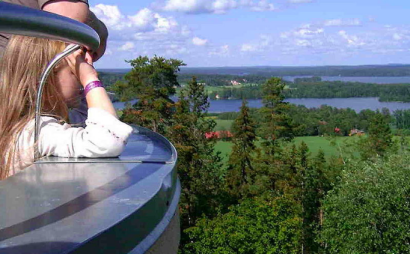
Kangasala Kirkkoharju, Kuohunharju, Keisarinharju and Vehoniemenharju are in line with Pispalanharju and Pyynikinharju in Tampere. Haralanharju is located further north on the western side of Lake Vesijärvi. About a quarter of the area of the city of Kangasala is water and there are another hundred lakes and ponds in the Kangasala area. The landscapes of Kangasala consist of lakes on the sides of the ridges. The three largest lakes in Kangasala are Vesijärvi, Längelmävesi and Roine. Lake Vesijärvi flows into the southern part of Längelmävesi. From Längelmävesi, water flows through the Kaivanto canal to Roine and from there on to Mallasvete and Vanajavesi. Other significant lakes are Heposelkä, Kirkkojärvi in the city center, Kirkkojärvi in the Sahalahti area, Keljonjärvi, Pakkalanjärvi and Kaukajärvi, Paalijärvi and Pälkänevesi, which are partly on the Kangasala side.
The ridge section across the fabric divides the city into two fairly distinct halves. In the southern part of the city, the terrain is fairly flat, and most of the city’s fields are located on the banks of the Roine that dominates it. In the northern part, the elevation differences are greater, and there are several rather high hills around Lake Vesijärvi and east of Längelmävesi, including Valkeavuori near Heponiemi (178 m asl) and Sahalahti's Kaakonvuori (180 m asl). The base between Vesijärvi and Längelmävesi is Mäkinen throughout and several bays of the lakes penetrate deep into it.
2.Ehoniemi car museum
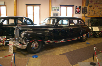
The Eautomuseo is a car museum built on Vehoniemenharju in Kangasala. The location of the Vehoniemi Car Museum is about 10 km from Kangasala, along Lahdentie near the Kaivanto canal. The distance to Tampere is about 25 kilometers. The Car Museum is also a traditional gathering place for motorcyclists. Next to the museum is the Vehoniemi observation tower, where you can see the lake and ridge landscapes of Kangasala and the nature reserve, where you can go hiking. The first observation tower was built between 1892 and 1893 and was demolished in the 1910s. The current observation tower was completed in 1927 and last renovated in the 1990s. From the museum car park, steep stairs lead down the ridge slope down to Roine beach.
The museum has a changing exhibition of about 50 restored vehicles. The Vehoniemi Car Museum has had the world's only Mercedes-Benz 300 SEL Waxenberger 6.3. Three of them were made. There is also a donated Trabant to the police. The museum also specializes in the ZIS-110 passenger car donated to the President of the Soviet Union JK Paasikivi in 1955, the Renault Nervasport sports car imported by the French ambassador to Helsinki in 1935 for personal use and the Oulu military master Väinö Neuberg. The museum also features mainly Japanese motorcycles from the early 1970s.
3. Kangasala Church
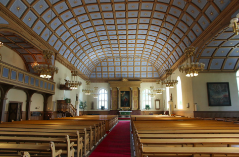
Kangasala Church is a stone church built in the 1760s in the center of Kangasala in the Pikkola district near Kirkkoharju. The church was built by Antti Piimänen on the basis of a plan prepared by the Swedish Superintendent's Office. It was commissioned without a tower in 1767, but finally the church with its towers was completed in the autumn of 1776. The church tower collapsed in 1782 and the new tower was completed in the autumn of 1800. As a personal detail, the roof of the church is made up of hundreds of stars in frames. A stone has been built into the wall on the left back side of the church, which according to legend has served as the molding platform for Kaarina in Kuussalo. Drops of blood on the coat of arms of Kangasala symbolize this event. Kangasala Church is a popular wedding church and in summer it is a road church. A service is held at the church every Sunday at 10 a.m.
The current stone church was completed in 1767, but the cemetery around the church was commissioned as early as 1650. The area of the cemetery is about 1.2 hectares. In addition to the old cemetery, Kangasala also has two other cemeteries, the Western Cemetery in the center, established in the early 20th century, and the Eastern, or Huutijärvi, cemetery established in the 1930s. The old cemetery has a Finne family grave. Jalmari Finne was a writer, translator, theater director and family and settlement historian born in Kangasala. Finne wanted to honor the memory of his mother Wilhelmina Finn with a tombstone. Jalmari Finne has donated a communion ware, a fair vase, a baptismal font, a church bell and a memorial stone “For Those Who Have Forgotten” to the Kangasala parish.
六、历史文化
1.历史
The name Kangasala is first found in documents in 1403, when it had been separated from Pirkkala for about half a century. Kangasala Church was originally located in the village of Luksiala on the banks of the Roine, from where the name spread throughout the parish. It has been speculated that the location of the church as seen from Pirkkala "under the cloth", i.e. in Kangasala, has influenced the birth of the name.
The church was not placed in its present area until the 17th century, so the birth of the name could not have been due to the present church or church village. It is recorded in memory that when the people used to go to the fields of Tarpila, Pikkola and Rekiälä to bring rye, tear rye and sow turnips, they said they would go under the cloth. Based on the direction and terrain, this fits well with the view that Kangasala was initially located in the direction of Luksiala.
It has been concluded from the oldest residence finds that the Kangasala area has been inhabited since the Stone Age. Especially in Huutijärvi Sarsa, a large number of pieces of clay pots, chisels, axes, bones and even parts of copper objects have been found. Permanent settlement may have been born during the Iron Age, as indicated by cemeteries dating back to the beginning of the 4th century in the village of Tiihala.The name Kangasala first appears in a document in 1403. The old grandmaster of Kangasala became the later municipalities of Orivesi, Juupajoki, Eräjärvi, Längelmäki, Kuorevesi and Kuhmalahti. Kangasala has had large mansions. These include Luksiala Manor, home to Queen Kaarina Maununtytär in the late 16th century, and Wääksy Manor, home to Kaarina Hannuntytär. Other manors are Lihasula Manor, Sorola Manor and Tavela Manor.
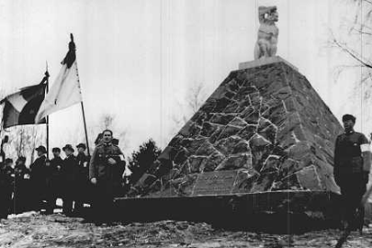
The descents of the Kangasala lakes have changed considerably over time. In the oldest times, Längelmävesi and Vesijärvi erupted into Roineee along the Sarsanvirta, and Pälkänevesi descended into Längelmävesi through the strait in Ihar. In June 1604, a natural disaster occurred, in which Pälkänevesi burst a new runway - Kostianvirta - to Mallasveti, Sarsanvirta dried up, the flow of water in Ihar reversed and Iharinkoski was born. As a result, Pälkänevesi began to flood over its crustaceans, and the surface of Längelmävesi also rose. In order to reduce the damage caused by the floods, the Mallasvesi runway Valkeakoski was cleared in the 1820s. Despite this, the surface of Längelmävesi rose steadily and was eventually two meters above the surface of Roine. In the end, it was decided to pierce the strait between Längelmävesi and Roine at its narrowest point. In April 1830, the structures of the newly completed canal of the Kaivanto canal were broken. The base of the ditch separating Längelmävi and Roine turned into an open canal in an instant and the surfaces of these lakes settled on the same level.
The stone church of Kangasala was built in the 1760s. Agathon Meurman, a Finnish man, politician and father of a Finnish encyclopedia, lived in Kangasala. He is also buried in the cemetery of Kangasala Church. Kangasala has been a traditional organ builder. The organ was built between the 19th century and the end of the 20th century. During the Finnish Civil War in 1918, the so-called Suinula massacre took place in Suinula, Kangasala. Kangasala formed an area of reds on the side of Tampere until the whites conquered Kangasala from March 22 to March 23 in the run-up to the Battle of Tampere.
The Pikonlinna Hospital was established in Kangasala in 1931, which initially operated as a tuberculosis sanatorium (Keski-Häme sanatorium) and during the Winter and Continuation War as a military hospital. In 1968, it was merged into Tampere Central Hospital, where lung and rheumatology wards were formed. The operations of Pikonlinna Hospital in this form ended in 2007, when new facilities were completed in Tampere. Near Kaivanto Canal is Kaivanto Hospital, opened in 1963, which was the B-mental hospital of the Pirkanmaa Hospital District. Kangasala was inhabited by Kivennava migrants after the last wars. The municipality of Sahalahti joined the municipality of Kangasala on 1 January 2005. Prior to the annexation of Sahalahti, the municipality had a population of 23,453 (2004) and an area of 479.31 km², of which 123.62 km² were water bodies. The population density in 2004 was 65.9 inhabitants / km².
2. 文化体育
There are 14 basic education units and a high school in Kangasala, as well as the Kangasala office of the Tampere Region Vocational College. Comprehensive education starts the year a child turns seven and it is compulsory. Enrolment in comprehensive school happens online in the January of the same year the child starts comprehensive school. The guardians of children living in Kangasala will be sent a username and instructions by e-mail. If you do not have internet access, you can also collect the enrolment form from a school near you or print it from the Kangasala website. New students moving to Kangasala should contact the school or the educational administration.
The sport and leisure services of Kangasala serve all citizens, sports clubs and organisations having to do with sport and leisure. Kangasala provides health-enhancing physical activities for people of all ages. The sport and leisure services maintains the calendar of the sport halls and courts and rents out the camp and leisure centres.
https://www.kangasala.fi/kaupunki-ja-paatoksenteko/briefly-in-english/education-and-leisure/sports/
七、其他信息
According to Kangasala, the name is derived from the word "kangas", which is an ancient Germanic loan and is related to the German words Gang and Swedish gång and means a corridor, a hard-bottomed route or the like. The Kangasala ridge has been a central route throughout the ages. The name as a whole means the same as "fabric industry", but it belongs to another word type: threshold / threshold area, sky / heaven area, canopy / canopy industry. The inflection of the name is thus irregular: one goes to Kangasala (not "Kangasala" or "Kangasala"). However, a person living in Kangasala is referred to as Kangasala, and the form Kangasala is also used in non-mobility contexts, e.g., "Kangasala is a characteristic feature ..." or "derivative. It comes from a prehistoric period when water bodies were 8-14 meters higher than they are today. There were several waterways and a couple of bays came into the area with a high ridge between them. The site has been inhabited continuously since the Stone Age. The Ugris vocabulary comes from before the beginning of the era, when the Pirkkala area was an important hub for traffic, transporting salmon, tar and furs south.
八、联系方式

Town manager: Oskari Auvinen
Phone: +358 40 133 6311
Email: kirjaamo@kaarina.fi
Address: P.O. Box 50, 36201 KANGASALA
https://www.kangasala.fi
https://www.kangasala.fi/kaupunki-ja-paatoksenteko/briefly-in-english/town-administration/the-mayor/
