Lège-Cap-Ferret, Gironde, Nouvelle-Aquitaine 作者: 来源: 发布时间:2021-09-25
I.Population and Area
Total Area: 93.62 km2
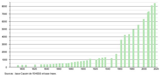
Population in 2017: 8 409
Population Density: 90 /km2
Histogram of demographic change
II.Natural Geography (environment and resources)
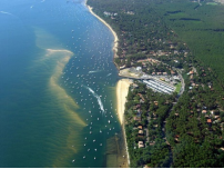
Lège-Cap-Ferret (Lèja-Cap-Herret in Gascon) is a commune in the southwest of France, located in the department of Gironde, in the Nouvelle-Aquitaine region.
Its territory consists mainly of a peninsula located between the Arcachon basin and the Atlantic Ocean on which is, from north to south, an agglomeration of several villages: Lège (town), Claouey, Le Four, Les Jacquets , Petit Piquey, Grand Piquey, Piraillan, Le Canon, L'Herbe, La Vigne, Cap Ferret and La Pointe.
The town is bounded by Cap Ferret to the south, the Atlantic Ocean to the west, the Arcachon basin to the east and the towns of Porge (to the north) and Arès (to the east).
The municipal territory stretches for about twenty kilometers between Cap Ferret and its north-eastern end.
The main village (bourg) is located about 40 km from Bordeaux and 25 km from Arcachon by road (only 10 km as the crow flies); Cap Ferret, 15 km from the center, is located 5 km from the port of Arcachon.
Relief:
The municipality of Lège-Cap-Ferret includes the entire peninsula of Cap Ferret, which separates the Atlantic Ocean from the Arcachon basin.
This land of "sand and water" was formed during the last millennium by the accumulation of sandbanks taking for support the mainland lands of the barony of Lège.
The territory of the peninsula and that located to the west of the canal is made up of a majority of dunes which were stabilized from 1850. The territory of the village of Lège is uniformly flat with an average altitude of less than 5 meters.
Hydrography:
Recent urbanization significantly modifies the hydrographic system.
On the dune area of the peninsula, the lettes located between the "white dunes" have become building areas, which implies the disappearance of the forest which no longer plays its role of regulating the hydraulic system.
In the village of Lège, the wetlands have dried up and are urbanized. In these areas, nature partly regains its rights, in rainy period the water rises to the surface.
In this village, the stream "la berle d'Ignac" (now the Machinotte) remains the only one still recognizable. It once had a utilitarian role, it was used for the community washhouse of Ignac.
The stream descending from the Grand Ousteau (used for the wash house located at the junction of the avenue du Moulin and that of the Médoc) has largely disappeared (replaced by a narrow covered ditch). He throws himself into the Machinotte.
The stream coming from Riou and crossing the center of the village turns into a small diameter concrete pipe passing under the retirement home and under the college. It was used for the washhouse known as "the town hall". It had an economic function, it was used by the village blacksmith until the 1950s.
A stream that can be compared to the current of Huchet (in the moors) which originates in the ponds of Le Porge and flows into the Bassin d'Arcachon. This stream, which is called the canal des étangs (without any historical reference), was called the Leige in some regional newspapers more than 120 years ago.
There are a dozen villages, located along the Arcachon basin (while the Atlantic coast is uninhabited), from north to south:
1)Light
2)Claouey
3)Le Four (oyster port)
4)Les Jacquets (oyster port)
5)Little Piquey
6)Grand Piquey
7)Piraillan (oyster port, natural reservoirs)
8)Le Canon (fishing village which organizes the Sea Festival around August 15)
9)L'Herbe (oyster village)
10)La Vigne (marina)
11)Cap Ferret
Communication routes and transport
The main communication route is the D 106 which goes from Bordeaux (Judaic barrier) to the tip of Cap Ferret.
A permanent maritime link exists between the pier of Bélisaire and the port of Arcachon.
III.Economy
Employment rate (%): 73.9 (2017)
Poverty rate by age group of the tax advisor(%): 10 (2017)
Average income per family (€):2 678 net per month (32 132 net per year)(2014)
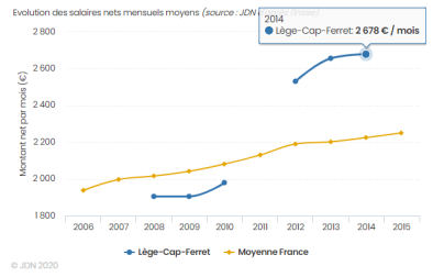
Evolution of average monthly net wages per family
Sources : http://www.journaldunet.com/business/salaire/lege-cap-ferret/ville-33236#:~:text=Les%20habitants%20de%20L%C3%A8ge%2DCap,132%20%E2%82%AC%20nets%20par%20an.
https://www.insee.fr/fr/statistiques/2011101?geo=COM-33236
IV.Industrial Characterisitics
Beyond the oyster farming activity, Cap Ferret lives mainly from tourism during the summer season (restaurants, bars, etc.). It has a nightclub, the Centaure, opened in 1984 and renamed the Sun in 2016. Another, the Six, opened in 2008, closed in 2017, being looking for a buyer.
History of the industrial fabric. Since the end of the twentieth century, the industrial fabric has been diffuse and made up of a large number of craft businesses and very small businesses (TPE), and a few small businesses. All of them specialize in areas related to tourism development (building, public works, water sports).
Since the mid-nineteenth century there have been a number of creations with a lifespan not exceeding a few decades
- First half of the 19th century. Installation of an industrial forge near the estey connecting the Porge ponds to the Arcachon Basin. The coal came from Spain by boat, the ore (at very low grade came by animal cartage from a production site in the town of Porge. The production was extremely low. The site was quickly dismantled.
- Second half of the 19th century. Pine plantations are profitable. The resin resulting from the gemmage is exported. To make this production profitable, the GORRY family set up a factory (route de la gare) for distillation in order to produce turpentine and other chemicals. This installation will close at the beginning of the following century
The plantations must be "thinned". The antlers are about fifteen centimeters in diameter. They are used for timbering in mine shafts. It was at this time that an export site was created between Lège and Claouey at a place called "Jane de Boy". This port which does not have any infrastructure worthy of the name will quickly be abandoned.
The pines which are about fifty years old are exhausted by tapping no longer have any economic value, they are felled. It was at this time that the mayor of Lège (Mr. GUERIN) set up an important sawmill. This establishment, after having had several owners, will close its doors (victim of the appearance of cardboard for packaging, carpet replacing parquet) around 1980
- First half of the twentieth century. Creation of four sawmills in the Village (M .. and D .. near the train station, L .. opposite the old distillation plant, J ... in the center of the village. These different businesses will close in the 1960s.
1955, creation of a dairy. The milk was collected from the farms as far as the Médoc. it was processed and sold (in summer throughout the peninsula. This enterprise lasted about twenty years. It disappeared victim of new discoveries for the treatment of milk, which became a product that can be preserved.
V.Attractions
1.Church of St. Peter
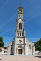
The current church of Lège is recent and was built from 1928. It replaces the very old church built between the sixteenth century, under the reign of François I, and the seventeenth century, under the reign of Louis XIV and which would have was the third church of Lège (see above “Relocation of the village of Lège”). For centuries, Lège has been a stopover for pilgrims going to Santiago de Compostela by the “Soulac route”. In the 12th century, the pilgrim's guide located the tombs of several of Roland's companions near the Saint-Pierre de Lège church. This old church, in a fortified style with small openings, became too small and was therefore demolished in 1925. Built on the same site, the current Saint-Pierre de Lège church still contains vestiges of the previous building: engraved stone, coat of arms of the lords premises and Roman capital. It is in neo-Romanesque style and is distinguished by an imposing bell tower with crows.
2.The Sainte-Marie chapel
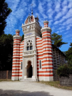
The Sainte-Marie chapel, Moorish chapel of the Algerian villa or chapel of L'Herbe, located in the village of the same name. Built in the 1930s, it is the last witness of a Moorish estate partially destroyed in 1965 to make way for a new residence. It is the only Moorish-style chapel intended for Catholic worship in France. On the steeple of the chapel are the cross and the crescent, symbols of Christian and Muslim cults. It is the work of architect Jean-Eugène Ormières and was commissioned by Léon Lesca, general councilor of La Teste (from 1873 to 1897), who had made his fortune in Africa.
It is the architect Jean-Eugène Ormières (1823-1890) who realizes, in 1884-1885, this building of neo-Moorish style, intended for the catholic worship. Indeed, until then, Cap Ferret did not have a place of worship and you had to go to Arcachon by pinnacle to attend mass, which was dangerous. Although it is a private chapel, it is used by the inhabitants of the surrounding oyster villages. Léon Lescat obtains the authorization of the President of the Republic Jules Grévy to build it.
It is part of the “orientalizing” architectural movement which developed in the Arcachon basin in the second half of the 19th century (Moorish Casino of Arcachon, villas of the city of Winter, etc.). On the bell tower, an astonishing connection between the cross and the crescent moon, a Latin inscription "gloria Deo" and a second in Arabic, "welcome to you", reflect the cultural influences of the sponsor. It is a symbol of openness and peace. The polychromy, the presence of ceramic tiles with geometric and floral motifs, the use of the horseshoe arch, here polylobed, illustrate the influence of the Moorish style. Inside is a chandelier made of wood, glassware, porcelain and pompoms in multicolored fabrics as well as a five-pointed star, significant for the three religions of the book (the five pillars of Islam, the five books of the Torah or the five wounds of Christ and the five joyous mysteries).
The Sainte-Marie-du-Cap chapel was blessed on September 8, 1885 by Father Lacouture. It remained for a long time the only place of worship on the peninsula; one came there on foot through the forest. The first and only chaplain was Father Noailles. Property of the city of Lège-Cap Ferret since its sale by the diocese for a symbolic € 1, it has been listed in the inventory of historical monuments since August 2008, it is still assigned to Catholic worship.
In June 2011, a complete renovation was completed. Today, Masses are celebrated there in summer and weddings or baptisms for the usual residents of the village of L'Herbe. In summer, it hosts celebrations and concerts.
3.Cap-Ferret lighthouse
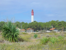
The first Cap-Ferret lighthouse was planned in 1792. It was not built until late and put into service in 1840. It was a tower of 47.7 m for an elevation of 51 m. Electrification took place in 1929. In August 1944, before evacuating Cap-Ferret, the Germans blew it up.
A second lighthouse was quickly rebuilt and commissioned in 1947 at the tip of the peninsula. The inauguration took place on August 7, 1949. The new lighthouse is based on the plans of the old one. The tower is 52.1m for an elevation of 62m with a red flashing light every 5 seconds. The front door, in front, is surmounted by a pediment showing the vintages of the commissioning (1840 and 1947) framing a bas-relief representing a ship sailing on the sea, where a fish figure and surmounted by the star symbolizing the lighthouse. The reception hall has a mosaic by master glassmaker Auguste Labouret (1871-1964) representing the Arcachon basin and the Cap Ferret peninsula, as well as two busts: that of the hydrographic engineer Beautemps-Beaupré (1766- 1854) and the physicist Fresnel (1788-1827), inventor of the lenses of the same name.
Visit
The lighthouse is open to visitors. A staircase of 258 steps gives access to the summit, from which one discovers a very extensive panorama on the peninsula, the Arcachon basin, the passes and the ocean.
An exhibition in several adjoining rooms presents the evolution of the topography of the Arcachon basin and its surroundings, nautical charts and navigation instruments. In the same building is a shop.
4.Old town hall
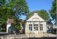
After the revolution of 1789, for lack of public building, the municipal council met sometimes at the mayor's, sometimes at a councilor or in a barn. It took almost seventy years for the new town to buy land and build a town hall. In 1868, Lège finally had a building consisting of two rooms, one of which served as a school. In 1888, an additional room was added towards the front in the center of the previous building to enlarge the town hall. This extension date appears on one of the three pediments that adorn the building. In 1877, to separate the sexes, a girls' school was built in the playground (now on the other side of the road). In 1912, this building will be assigned, as indicated on the pediment, to the “small” section. In 1992, the town hall will benefit from a new "town hall" built by the architect Jean-Jacques Lacaze on the site of the "Maison du Baron" opposite the town hall. The old town hall will be restored and converted to accommodate the leisure club and other associations.
VI.History
Modern times
Ogier de Gourgues and his widow Lady of Aspremont, lords of Lège from 1572 to 1600
Around 1572 the Chapter had to sell the barony of Lège to Ogier de Gourgues who was president of the Guyenne Finance Office, for the sum of 1225 ecus. In 1584, Ogier de Gourgue, was the first lord of Lège to grant against payment, the right to hunt waterfowl to 22 inhabitants of La Teste on a piece of land with white sand, called "white earth" located on the peninsula (between "large and small sea") currently located in Jacquets. When he died in 1583, the Duke of Epernon, Captal de Buch, Lord of Lesparre and Castelnau, coveted the barony of Lège which would allow him to be master of the shore of the Gironde estuary in the Arcachon Basin. But Ogier de Gourgue's widow, Finette de Pellegrue, Dame d´Aspremont refuses to sell.
The Dukes of Epernon, Captals of Buch, Lords of Lège from 1600 to 1664
Jean-Louis de Nogaret (1554-1642), first Duke of Epernon, great lord of the time close to the royal power of Louis XIII, manages to break the sale with the complicity of the Chapter which will come into the possession of the barony of Lège, compensate Dame d'Aspremont for 1225 crowns and sell the barony to the Duke of Epernon for 15,000 pounds. Thus, Lège will enter the domain of Captal de Buch in 1600. It was not until 1628 that the first Duke of Epernon conceded the hunting of waterfowl, in particular in the letters to people of Lège. This is what makes that at the time of the Revolution, the inhabitants of Lège became owners of these letters. When Jean-Louis d'Epernon died in 1642, Bernard d'Epernon took over from his father, as Captal until his death in 1661. The Captalat passed to Jean-Baptiste Gaston de Foix-Candale (1638- 1665).
From 1664 to 1751, the Durforts and the Sallegourde
In 1664, the barony left the Captalate of Buch and was sold to Guy Alphonse de Durfort, knight of the king's orders, marquis de Duras and de Blanquefort. Then at the beginning of the 18th century, the barony passed to Gabriel de Raymond, knight, marquis de Sallegourde, marquis of Ayran, councilor in the Parliament of Bordeaux On August 16, 1751, the barony was bought by Jean-François de Marbotin.
The Marbotins, lords of Lège from 1751 to 1789
Jean-François I de Marbotin (1706-1764) is Advisor to the Parliament of Bordeaux. The Marbotins got their property, not from feudal power, but from regular purchase. This will allow them, after the Revolution which puts an end to the feudal system (night of August 4, 1789), to assert their right to property before the courts. Until the Revolution, the barony of Lège-en-Buch belonged to the Pays-de-Buch without depending on the Captalate of Buch, a seigneury only made up of the three parishes of La Teste, Gujan and Cazaux. With the neighboring seigneury of Ignac, this barony constitutes the parish of Lège.
The lands of this barony were then limited by those of the parish of Arès to the east, by lands belonging to Captal de Buch to the north and by the ocean to the west and south. As time goes on with the meeting of the sandbanks which are deposited there on the continent, a sandy spit forms, lengthening the territory of the barony towards the south; the lords of Lège took advantage of this to appropriate these sea lays, “spaces of white dunes and water holes (crohots)” constituting Cap-Ferret (or Cap-Herret), an interesting space for the capture of large quantities of waterfowl.
Claim of the Cap Ferret peninsula by Captal de Buch and Baron de Lège
At the time of the first attempts to fix the coastal dunes, and wishing to obtain those of the locality Piquey to plant pines, François Amanieu de Ruat the Captal of Buch at the time, obtained the concession by decree of the Council of King Louis XVI. This decision of March 23, 1779 had the effect of placing the entire peninsula under the jurisdiction of Captal. During the territorial reorganization of 1790, which saw the replacement of parishes by municipalities, the said concession of 1779 was at the origin of the attachment of Cap-Ferret and the hamlets therein to the municipality of La Teste. It was only under the reign of Louis XVIII, on March 23, 1807 that the boundary separating the town of Lège and that of La Teste was defined along a straight line going from the “Green Truc” on the ocean side to the “Pointe aux horses” side. Arcachon bay.
The Cap-Ferret remote district of La Teste remains a wild and uninhabited place (Jacques Ragot). From the end of the 18th century, seine fishermen coming mainly from the south of the basin (from La Teste, Mestras or Meyran) set up temporary accommodation there each summer (huts or rudimentary huts backed by the dunes) to be as close as possible of their fishing grounds.
Revolution and Empire
The commune of Lège was created at the start of the Revolution (creation of communes and departments in 1789) on the territory of the parish of Lège which included the territory of the baronies of Lège and Ignac32. At that time, Lège bordered on Andernos (which included the territory of Arès), from which it was separated by a stream, the “berle d'Ignac”.
In 1807, under the First Empire, to prevent a possible English landing, La Pointe was fortified with a battery of four cannons and a mortar, served by 30 to 50 men. A semaphore is built at the same time. In 1810, under the command of a sergeant, 50 soldiers of the 9th Polish regiment garrisoned there.
On the death of the former Baron de Lège in 1793, the municipality of Lège seized all the properties of the Marbotins. The heirs did not protest but, at the Restoration, they attacked the town, before the thirty-year statute of limitations, and definitively obtained the restitution of their property in 1826. In the same year, they sold all of their land, ie around 2,000 ha of moors. shaves and 1,800 ha of lettes, encumbered with user rights, to the Société des Landes de Gascogne30.
Contemporary period
The Société des Landes de Gascogne was created on February 4, 1825 by Pierre Balguerie-Stuttenberg, and he entrusted its management to his older brother Jacques Balguerie (1773-1850). Its corporate purpose was "the acquisition and resale of uncultivated land or heathland located between the Garonne and Adour, commonly known as Landes de Gascogne". The 3 shareholders are the Balguerie & Co house, the Oppermann Mandrot bank in Paris and the 3 brothers Louis, James and Frédéric de Pourtalès from Neuchâtel in Switzerland. Pierre Balguerie-Stuttenberg died at the end of 1825, the year of the creation of this land speculation company. The Société des Landes de Gascogne was liquidated in 1855 on the death of James de Pourtalès.
Hitherto summed up by the gathering on foot or the dredging in deep water of wild oysters, oyster farming was organized methodically from the middle of the 19th century. The adoption of an innovative technique for collecting oyster spat developed by the Arcachonnais Jean Michelet and the creation of the first flat oyster beds locally known as the "gravette" (Ostrea edulis) are at the origin of 'an activity with a bright future. Around 1880-1890, oyster farming is booming and the oyster farmers of La Teste, Gujan and Arès obtain new concessions on the north shore of the basin. To get closer to their workplace and save themselves from long trips by oar or sail from their home ports, they bring pontoons or build huts (often without permission) on the beaches of L'Herbe, Canon, Pirailhan, Claouey, Jacquets or Piquey located on the edge of the Bassin d'Arcachon. Some stay there longer and longer until they become, over time, a permanent habitat.
An old track of poor quality linked the villages to the town of Lège, before the development of a real road, the D106, at the beginning of the 20th century, favoring the arrival of the first tourists among whom are Jean Cocteau and Raymond Radiguet.
During the Second World War, like the entire French coast from Belgium to Spain, Cap-Ferret was in a “forbidden zone” and a few blockhouses on the Atlantic wall were built there. The one closest to the entrance to the Basin in front of “Hortense” is “made up” by the artists of the Organization Todt to resemble a villa: false tiles and false windows are painted on the concrete. At the time of their retirement, at the end of August 1944, in addition to various sabotages affecting the electric and telephone lines, the German occupiers blew up the lighthouse which, since 1840, had signaled the entrance to the Basin.
It was in 1976 that the current territory of the municipality took the name of "Lège-Cap-Ferret" when the southern part of the peninsula (belonging to the municipality of La Teste-de-Buch) was attached to the municipality of Lège. On this territory were the villages of Grand Piquey, Piraillan, Le Canon, L'Herbe, La Vigne, Le Cap Ferret. The word Cap Ferret that we find in the new geographical entity does not come from the name of the village of the same name but from the extreme south of the territory which is a geographical place whose geographical position has moved several kilometers in 5 centuries. [citation needed] The attachment in 1976 to the municipality of Lège was made at the request of the inhabitants of the villages concerned, after acceptance by the municipality of La Teste, authorization from the Ministry of the Interior and agreement from the municipal council of Lège. [citation needed] You should know that 3 times, in 1905, in 1945, in 1954, the inhabitants of the village of Cap Ferret had received from the authorities an end of refusal to their request to become a full-fledged municipality. [citation needed ] No municipal deliberation having taken place on a change of name of the inhabitants, the traditional names remain in force (Lègeots or Lègeois for the inhabitants of Lège and Capiens for those of the village of Cap Ferret).
However, as regards the rights of access to the user forest of La Teste, the traditional rights are maintained for the inhabitants of Cap Ferret.
Lège-Cap-Ferret is subject to an archaeological zoning decree concerning part of the center of the village and the place called “dune de Campagne” (prefecture Aquitaine region - DRAC - decree AZ 073311 of 6 August 2007).
The town is today a seaside resort known for its ocean beaches of Grand-Crohot, Truc Vert and Horizon.
VII.Other information
THE ECO'BAN ENERGY RENOVATION PLATFORM: A LOCAL PUBLIC SERVICE
What is ECO’BAN?
Thanks to the support of ADEME, our Agglomeration Community has launched the first platform for energy renovation of housing in the Basin since 2017.
ECO'BAN is a public service, offering NEUTRAL AND FREE ADVICE, to individuals and craftsmen in the COBAN territory who would like to be supported at each stage of an energy renovation project (estimate analysis, advice on works, heating system, information on existing financial aid).
The coordination of the ECO'BAN platform is entrusted to CREAQ (Center Régional Ecoénergétique d'AQuitaine), which, in partnership with COBAN, provides regular service in each municipality and activities in the Arcachon North Basin territory.
ECO'BAN works closely with craftsmen by directing individuals to financial aid adapted to their projects and by supporting them in the constitution of aid files.
Sources: http://www.ville-lege-capferret.fr/actualites/ecoban-plateforme-de-renovation-energetique/
VIII.Contact information
LÈGE-Cap FERRET town hall address :
79 avenue de la Mairie
33950 LÈGE-Cap FERRET
Mayor : Philippe De Gonneville
Mail: accueil@legecapferret.fr
Phone number: 05 56 03 84 00
Website : http://www.ville-lege-capferret.fr/
