Le Verdon-sur-Mer, Gironde, Nouvelle-Aquitaine 作者: 来源: 发布时间:2021-09-24
I.Population and Area
Total Area: 17.09 km2
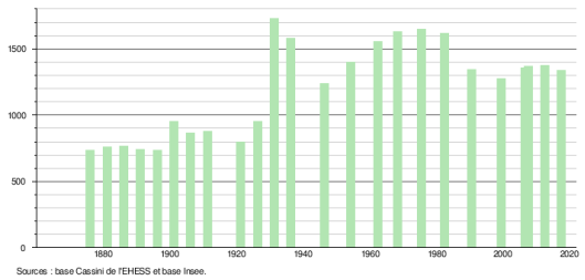
Population in 2017: 1 335
Population Density: 78 /km2
Histogram of demographic change
II.Natural Geography (environment and resources)
Le Verdon-sur-Mer is a town in southwestern France, located in the Gironde department, in the Nouvelle-Aquitaine region.
Location and access:
Verdon-sur-Mer has a particular geographical location: triangular in shape, it is located at the meeting point of the Gironde estuary and the Atlantic Ocean, at the northern end of the Medoc peninsula.
The town is the most northerly of the Landes de Gascogne. It faces the Charente coast and the town of Royan, 9.5 km away, which is accessed by a ferry. Close to Soulac-sur-Mer, from which it is 5.8 km away, it is also 12.7 km from Saint-Vivien-de-Médoc, 28.2 km from Lesparre-Médoc and 86.8 km from Bordeaux, the departmental and regional prefecture.
Belonging to the “Atlantic South”, in the heart of the Atlantic Arc, it is an integral part of the Great French Southwest.
On the municipal territory begin the departmental road D 1215 (former N 215, in turn former D 1N 1) which leads to Saint-Vivien-de-Médoc in the south then to Bordeaux in the south-east and the departmental road D 101, more to the west, which leads to Soulac-sur-Mer and Vendays-Montalivet.
The “Gironde” bac in 2009.
A river ferry service crossing the estuary provides the link between Le Verdon (Port Bloc) and Royan. Its traffic reaches almost one million passengers per year: 907,000 passengers in 2010, against 689,800 in 2002, mainly thanks to the modernization of ships.
The closest motorway is the Bordeaux ring road, exit 8 of which is 91 km away by road towards the south-south-east.
The town has 2 SNCF stations (one in Bourg since 1875, the other at Pointe de Grave since 1902) on the Médoc line of the TER Aquitaine, an electrified line connecting Bordeaux to the Pointe de Grave (terminus of this line ).
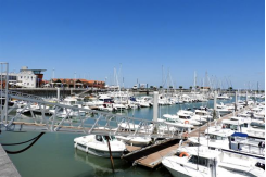
Le Verdon-sur-Mer is a small seaside resort with two supervised beaches: one on the ocean, the other on the estuary, as well as a marina built in 2004: Port Médoc, and an older, Port Bloc, where the Royan ferry arrives.
Bordering municipalities:
Verdon-sur-Mer faces the municipalities of Royan, Saint-Georges-de-Didonne and Meschers-sur-Gironde, on the right bank of the Gironde estuary, these municipalities being Charentaise.
Offshore, on a rocky islet, the Cordouan lighthouse, built between 1584 and 1611 and raised in 1789, marks the entrance to the estuary.
Hamlets and localities:
Le Verdon-sur-Mer is a seaside resort comprising six beaches: the fluvial beach of La Chambrette, the ocean beach of Saint-Nicolas, and four wild and unsupervised ocean beaches: the beach of Arros on the borders of Soulac-sur-Mer (terminus of the little tourist train running on the old rail lines of the Autonomous Port of Bordeaux formerly used for coastal maintenance), Cantines beach, Maison de Grave beach and Claire beach, north of Saint- Nicolas (former site of Maison Carrée) at the tip of Grave.
On some sites, the Arros beach which is located in the territory of Verdon-sur-mer is sometimes wrongly attributed to Soulac-sur-mer because it is very close to this town.
The municipality of Verdon-sur-mer also has four ports (Port-Bloc, Port Médoc, the large maritime port of Bordeaux, the old oyster port) and three lighthouses (the Grave lighthouse, the Saint-Nicolas lighthouse and the Cordouan) and five hamlets distributed on both sides of the Bourg: the Grands Maisons (local spelling), the Royannais, the Huts going south, the Logis (always written like this on civil status documents, writes the Logit on some maps!) And Pointe de Grave to the north.
Sources : http://www.ville-verdon.org/
III.ECONOMY
Employment rate (%): 65.9 (2017)
Average employment income (€):1 739 net per month (20 868 net per year)(2018)
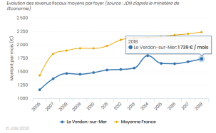
Evolution of average monthly net wages
Sources : http://www.journaldunet.com/business/salaire/le-verdon-sur-mer/ville-33544#:~:text=Les%20habitants%20du%20Verdon%2Dsur,par%20an%20et%20par%20foyer.
https://www.insee.fr/fr/statistiques/2011101?geo=COM-33544
IV.Industrial Characterisitics
Ports:
The town hosts a port site dependent on the autonomous port of Bordeaux.
1)Port Médoc:
Port Médoc consists of a basin with an area of 15 hectares, with a draft of two to three meters. Accessible 24 hours a day, it has 800 rings, a capacity that should be increased to 1500 rings in the future.
The port also has a docking area, a storage area, a launching dock (6.5 meters wide) with a boat lift (35 tonnes maximum), a service station accessible 24 hours a day (CB ), a slipway (15% slope ... paying), a laundromat. The surroundings of the port have been treated in a contemporary way, forming a marina inspired by its architecture from the Scandinavian countries: succession of esplanades bordered by small wooden structures, deliberately limited to one floor in order to better integrate into the landscape. They accommodate around twenty shops (nautical, delicatessen, clothing, beach items, decoration, real estate agencies, etc.), bars and restaurants. The whole is structured around a captaincy with avant-garde forms.
In 2015, Port Médoc was awarded - for the eleventh consecutive year - the European Blue Flag eco-label, which rewards exemplary environmental quality.
Shops:
A few local shops are located in the town center as well as on the Port Médoc site. An E.Leclerc supermarket opened in the town center in June 2013. With a sales area of nearly 2,000 square meters, it complements the existing offer in the neighboring town of Soulac-sur-Mer (Carrefour Market and Lidl).
1)E.Leclerc
E.Leclerc is a cooperative of traders and a retail chain predominantly food of French origin. From the first store opened by Édouard Leclerc in 1949, it now includes independent stores. The organization employs approximately 125,000 people.
In 2007, E.Leclerc launched into mobile telephony with E.Leclerc Mobile. In 2008, E.Leclerc was the leading brand in France with a 16.4% market share and € 34.7 billion in sales. Its main competitor in this market is Carrefour, which has a 13.2% market share.
In 2014, 18.3 million households visited the E.Leclerc brand at least once (419,000 more households than in 2008).
Specialty stores
The fleet of specialized concepts represented 1,619 points of sale in 2016 and contributed 19.9% to the growth of the E.Leclerc brand34.
The most popular specialized concepts: L'Auto E.Leclerc - Animalerie E.Leclerc - Brico E.Leclerc - Jardi E.Leclerc - Espace Culturel E.Leclerc - Voyages E.Leclerc - Le Manège à Bijoux E.Leclerc - Optique E .Leclerc - Parapharmacy E.Leclerc - Une Heure pour Soi - Sport E.Leclerc - Jouet E.Leclerc - Location E.Leclerc - Audition E.Leclerc.
A repositioning and expansion of the non-food private label ranges was undertaken in 2015 with the creation of 760 new references, which makes it possible to strengthen the attractiveness of the non-food offer in the hypermarket department, specialized concepts and Internet.
The E.Leclerc Cultural Spaces sell tickets for major national events using the France Billet computerized ticketing service.
Tourism:
1)The marina of Port Médoc
2)Small tourist train of the PGVS association (Pointe de Grave, Verdon, Soulac) connecting the Pointe de Grave to Soulac (les Arros). It circulates in summer, on its own railway and in the forest, not far from the cycle path along the coast.
V.Attractions
1. Cordouan Lighthouse
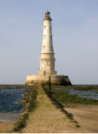
The Cordouan lighthouse is a lighthouse located seven kilometers at sea on the Cordouan plateau, at the mouth of the Gironde estuary, an estuary formed by the confluence of the Garonne and Dordogne rivers, overlooking the Atlantic Ocean. It illuminates and greatly secures traffic in the two passes allowing access to the estuary: the Great Western Pass, signposted at night, which runs along the north shore from the Coubre bench, and the South pass, more narrow, and not marked at night.
It is located in the department of Gironde, in New Aquitaine, between the towns of Royan, Vaux-sur-Mer and Pointe de Grave, on the territory of the municipality of Verdon-sur-Mer, on which it appears at parcel number 1 of the cadastre.
Built from 1584 to 1611, it is the oldest lighthouse in France still in operation. Sometimes called the "Versailles of the sea", the "lighthouse of kings" or even the "king of lighthouses", it is the first lighthouse classified as historical monuments by the list of 1862.
The site is the property of the State, represented by the interregional direction of the South Atlantic Sea, whose services of the Verdon ensure that the lighthouse continues to fulfill its mission of maritime signaling and securing the passes every day.
The tourist promotion and guarding of the site have been delegated by the interregional management of the sea since January 2010 to the mixed union for the sustainable development of the Gironde estuary (SMIDDEST), bringing together the departments of Gironde and Charente-Maritime , the Nouvelle-Aquitaine region, the metropolis of Bordeaux, the community of agglomeration Royan Atlantique, the community of municipalities of the Estuary and the community of municipalities of Haute Saintonge, in close collaboration with the association for the preservation of the lighthouse from Cordouan. In addition, since March 2009 emerges a land near the lighthouse, it is the unnamed island.
2.Port-Bloc
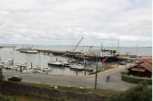
Located at Pointe de Grave, the port known as Port-Bloc is made up of a harbor basin delimited by a dike and by the Pointe de Grave jetty. It is the home port for the estuary pilots' boats, for the ferry connecting Le Verdon to Royan and for fishing and pleasure boats.
Sources :http://dossiers-inventaire.aquitaine.fr/dossier/port-bloc/88fd5326-5e70-4bd9-bd3a-8ab566251f56
VI.History
Archaeological discoveries indicate a human settlement from the Neolithic period (lithic tools in the Bois du Grand Logis, in Nicot). Archaeological excavations have shown the existence of an ancient exploitation and trade in salt in this sector of the North Medoc since protohistory.
For Antiquity, the accounts of Ausone (4th century), taken up and commented on by Father Baurein around 1784, also give the image of a prosperous region, with the riches lavished by estuarine waters (especially oysters and salt).
In the eleventh century, the territory of Verdon housed the priory of Saint-Nicolas de Grave, dependent on Cluny. It houses the monks responsible for the maintenance of the Cordouan fire, off the mouth of the estuary. The priory is buried under the sands for an indefinite period.
Hamlet of Soulac
Until July 1874, Le Verdon depended on the commune of Soulac. Note that 1874 is also the year of the construction of the Bordeaux-Le Verdon railway line which will open up the town and envisage a future port: this one started in sections from Bordeaux in 1868 will not reach Verdon than in 1875 and at the Pointe de Grave in 1902
The Verdon is therefore at the start only a hamlet of Soulac distant from the Bourg by more than a league (4 km for the Huts, 7 km for Le Verdon-Bourg, about 10 km for the Pointe de Grave) which lives from the production of salt for a very long time (very numerous salt marshes in the Middle Ages). The other main activities of the village are the exploitation of resources linked to the sea (fishing, oysters, shellfish ...) and subsistence farming.
The study carried out by Pierre Caillosse on the former parish of Soulac identifies references to houses in the archives: they are grouped together in the 17th and 18th centuries in the hamlets of Verdon, Logit, Grandes Maisons and Royannais. Salt-workers' houses are also isolated in the salt marsh areas.
Since the Middle Ages, Le Verdon has been known for its harbor sheltered from the prevailing westerly winds. Ships wishing to leave the Gironde estuary are stationed there before setting out to sea. Ships wishing to refuel on land disembark a few sailors who, with the help of a small boat, go up the Rambaud channel to the village. This channel is also used for shipping salt from the marshes.
In 1717-1723, a royal chapel was built to provide spiritual help to sailors. It bears the name of Notre-Dame-du-Bon-Secours and Saint-Louis. Its construction was financed by a levy on ships entering and leaving the estuary according to their tonnage (decree of the King's Council of 1712). This chapel was abandoned during the Revolution and served as accommodation for officers in garrison in the forts of Pointe de Grave. Returned to worship in the 1820s, it was destroyed to be replaced by the current church. The Verdon was set up as an autonomous parish in 1849, being detached from the parish of Soulac for the celebrations.
A customs post was established in the 1740s to collect the salt tax but also to monitor ships at anchor in the harbor.
Strongly subjected to marine erosion from the middle of the 18th century, La pointe de Grave is the subject of numerous protections against the retreat of the coast. They were initiated by the Ponts et Chaussées, the Gironde maritime service. Between Soulac and the Pointe de Grave, dikes, sea-breakers and breakwaters are built by the Ponts et Chaussées to retain the sand and break the onslaught of the ocean. 130 years of perpetual construction work stabilize the coastline. The jetty, built in 1844, still bears witness to this, at the end of the Pointe de Grave. Several generations of work are undertaken. The first, from 1839, consisted of the construction of a dozen groynes in the Anse des Huttes, very vulnerable due to the narrowness of the dune ridge and the presence of land close to sea level in back. 13 ears of corn are also built between the Pointe de Grave and the Claire beach. In order to preserve the forest, the engineer Brémontier had set up his first pine seedling workshop at the Pointe de Grave in 1801.
Autonomous municipality
After long procedures, the hamlets of Verdon, Logit, Royannais, Grands Maisons, Huttes and Pointe de Grave thus became in 1874 an autonomous commune called Le Verdon, standing out from the parish of Soulac.
The constructions multiplied in the nineteenth century with the taking of autonomy of the municipality and the development of the oyster port. In 1882, the cadastre registers count 187 houses, a windmill and a tile factory in the town of Verdon. This is probably the tile factory demolished in 1885 (plot A 487, belonging to Rigolier in the Logit marshes). In addition, a brickyard was installed on the border with the town of Soulac at a place called Beauchamp.
XXth century
Since a decree of 1911, Le Verdon has been called Le Verdon-sur-Mer.
The maritime vocation of Verdon-sur-Mer was further strengthened with the inauguration, in 1933, of the port of call, the outer port of Bordeaux. The largest liners of the 1930s docked at this port connected to the land by a viaduct over 340 meters long. Its construction, between 1929 and 1933, attracted a large workforce, often immigrants. Verdon-sur-Mer experienced a period of unprecedented prosperity and its population has never been exceeded since this period. Destroyed in November 1944 by the Germans controlling the Royan pocket and the Pointe de Grave, the port of call was for the time a flagship of technology. It accommodates a hundred transatlantic liners during its period of activity. In the years 1966-1986, an oil port was operating on the ruins of the old port of call. Three hydrocarbon depots are located in the town, supplying upstream refineries, at Ambès (Elf and Esso) and Pauillac (Shell).
This industrialization will affect oyster farming, which will be forced to stop in the 1970s (cadmium pollution). If the activity disappears, the huts of the old oyster port have been partly rehabilitated for tourism purposes.
Since the 1980s and the end of the industrialization of the Gironde estuary, Le Verdon-sur-Mer has therefore been committed to tourist development, backed by its heritage and its natural resources (beaches, forests, old marshes salt).
In 2004, Port Médoc, marina of 800 rings, was opened. It is accessible at all tides. Since its opening, it has received the Blue Flag. In recent years, the tourist vocation of the town has developed with the construction of tourist residences.
We have been farming prawns in the old marshes for several years now, and since 2014 we have started producing Medoc oysters, matured in the marshes.
VII.Other information
An estuary for all
Between 2007 and 2010, the town experienced a lively controversy over the possible establishment of an LNG port. By consultation, the inhabitants of the municipality (except the second homes which did not have the right to vote) voted against by nearly 70%. The biggest association in the village with more than 5,000 members was the association “Une pointe pour tous” which fought against the establishment of an LNG terminal. It gave way to the Collective "An estuary for all". At the start of 2019, the two banks of the estuary are still grouped together and are working in the same constructive spirit. The objective of the association is always the defense of residents, businesses and the environment, for a sustainable and controlled development, monitoring and control of all projects that could harm the Gironde estuary...
As of December 2018, the association has 1,000 members.
VIII.Contact information
Le-Verdon-sur-Mer town hall address :
9 boulevard Lahens, 33123 Le-Verdon-sur-Mer
Mayor : Jacques Bidalun (Mandate : 2014-2020)
Mail: contact@ville-verdon.org
Phone number: +33 5 56 09 60 19
Fax: 05 56 75 59 07
Website : http://www.ville-verdon.org
Sources : http://www.ville-verdon.org
http://www.cartesfrance.fr/carte-france-ville/33544_Le%20Verdon-sur-Mer.html#mairie
