Jau-Dignac-et-Loirac, Gironde, Nouvelle-Aquitaine 作者: 来源: 发布时间:2021-09-24
I.Population and Area
Total Area: 41.23 km2
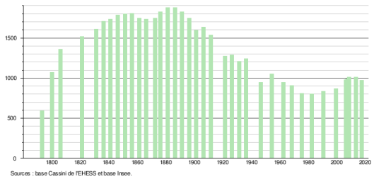
Population in 2017: 973
Population Density: 24 /km2
Histogram of demographic change
II.Natural Geography (environment and resources)
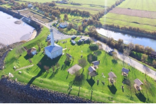
Jau-Dignac-et-Loirac is a commune in the southwest of France, in the department of Gironde (Nouvelle-Aquitaine region).
The town belongs to the district of Lesparre-Médoc and the canton of Saint-Vivien-de-Médoc.
Location:
The commune of Jau-Dignac et Loirac is located in the southwest of France. More precisely in the Médoc (Gironde), bordering the Gironde estuary on its left bank, about 30 km south of the Pointe de Grave, 15 km east of the beaches of the Atlantic Ocean and 80 km north of Bordeaux in the Gironde department and the Nouvelle-Aquitaine region (formerly Aquitaine Region).
The town covers 41.2 km2 and has 973 inhabitants at the last population census. With a density of 23.9 inhabitants per km2, Jau-Dignac-et-Loirac experienced a net increase of 13.9% of its population compared to 1999.
Surrounded by the towns of Valeyrac, Queyrac and Saint-Vivien-de-Médoc, Jau-Dignac-et-Loirac is located 6 km north-east of Queyrac the largest town nearby.
The municipality of Jau-Dignac-et-Loirac is part of the Medoc Atlantique community of municipalities.
Hydrography: Located at an altitude of 13 meters, the Ruisseau des Douze Pieds [archive] is the main river that crosses the town.
Weather:
The climate of Jau-Dignac-et-Loirac is of the Aquitaine oceanic type. It is characterized by mild and wet winters (rare frosts) and rather bright and dry summers on the whole.
Fog is infrequent (even if banks of mist are encountered, even in summer, near marshy areas, particularly humid).
Snow is very rare.
The risk of thunderstorms is moderate.
The risk of eddies is high compared to the rest of the country.
The frequency of high temperatures is normal (ten days a year).
The sunny day is rather usual.
III.ECONOMY
Employment rate (%): 70.7 (2017)
Average employment income (€):1 652 net per month (19 824 net per year)(2018)
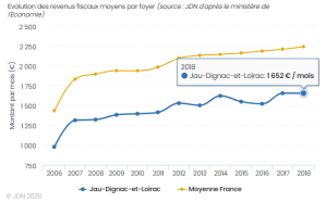
Evolution of average monthly net wages
Sources : http://www.journaldunet.com/business/salaire/jau-dignac-et-loirac/ville-33208
https://www.insee.fr/fr/statistiques/2011101?geo=COM-33208
IV.Industrial Characterisitics
In 2015, Jau-Dignac-et-Loirac had 101 companies established on its territory, including 41 retail and service companies, i.e. 40.6%.
Business and Commerce
1.Agriculture: Wine-growing area of the Médoc.
The region's land, which is mainly made up of alluvium and gravel, produces superior wine quality. Generally tannic and full-bodied, the Jau-Dignac and Loirac wines are a delicate accompaniment to red meats, in particular a good Bordeaux steak cooked to perfection with vine shoots!
Some companies:
Chateau Les Graves de Loirac
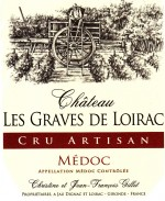
In Jau Dignac and Loirac, this small family farm extends over 8 hectares of gravelly soil between the Atlantic Ocean and the Gironde estuary, thus taking advantage of the microclimate beneficial to its vineyard.
The grape variety is made up of cabernet sauvignon and typical black merlot with an Aoc Médoc.
Depending on the vintages, the wine from these vines ages for 8 to 12 months in oak barrels while respecting its roundness and its fruity notes brought by the grapes harvested at their maximum maturity.
Château Les Graves de Loirac will brighten up your festive meals by accompanying the dishes of your choice.
Chateau Haut Gravat
Owner from father to son for more than five generations, this wine estate was reconstituted in 1960. In 1983, the penultimate generation and current owner, little by little, decided to improve its production, expand its vineyard and create new buildings. The vat room is thus enlarged, a barrel cellar and bottle storage built, as well as a tasting room and a tower to improve the reception of customers by allowing them to benefit, during the visit, from a magnificent view of the vineyard.
Located on a gravelly islet of Garonne origin, an exceptional advantage to the life of the vineyard, Château Haut-Gravat extends over 10 ha in the town of Jau-Dignac-Loirac. This village is located about ten kilometers from the ocean and two kilometers from the Gironde (Garonne estuary). This situation benefits from an advantageous microclimate when the grapes are ripe.
The grape variety of this one is made up of 31% Merlot, 17% Cabernet Franc and 52% Cabernet Sauvignon. This blend gives it aromas of red fruit as well as roundness and suppleness while keeping its aptitude for aging. Since 1983, the vineyard has seen its surface area go from 2 ha to 10 ha to date. This one is worked in the tradition and the respect for nature, since the beginning of 2015 we have suppressed the herbicides to return to the work of the ground as in the years 1980. On the vineyard one brings no chemical fertilizer and the applied treatments are are carried out in reasoned and unsystematic control so as not to pollute our precious environment).
2.Shops:
a)General grocery
b)Hairdresser
Sources: https://www.jau-dignac-loirac.com/France-Gironde-Jau-Dignac-Loirac-PRATIQUE.html
http://www.crus-artisans.com/fr/fiche/26
https://www.chateau-haut-gravat.fr/
V.Attractions
1. Richard's Lighthouse
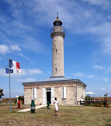
Richard's Lighthouse is actually two lighthouses.
The first, in stone, was built in 1843, put into service in 1845 and replaced because it was too small (18 meters) by a metal tower from 1871. This metal tower measured 31 meters and was used until 1953, date to which lighted buoys located directly on the navigation channel replaced it. In 1956, the metal lighthouse was destroyed for security reasons before the estate was put up for sale. In 1984 a group of young people from the village decided to clean up the overgrown areas. The then mayor supported the initiative and the municipality bought the lighthouse. Since its renovation, the site has been managed and maintained by volunteers from the Association Communale du Phare de Richard.
Richard's lighthouse is located in Jau-Dignac-et-Loirac. Like most of the lighthouses in the Gironde estuary, it is no longer in operation.
It is a cylindrical lighthouse, not high enough despite its 18 meters, built in 1843. Its spiral staircase has 63 stone steps and leads to the cornice. In 1870 another metal lighthouse 30 meters high, whose light was more visible, was built. This lighthouse was in service until 1953 and then demolished. The model of this lighthouse is on display next to it.
2.The archaeological site of "La Chapelle"
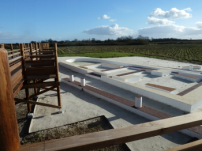
The archaeological site of "La Chapelle Saint Siméon" is located in the commune of Jau-Dignac and Loirac, on the left bank of the Gironde estuary and about 950m from the banks of the river.
The archaeological site appears on an ancient islet in the estuary: the “hamlet of Goulée”.
The remains unearthed attest to an occupation of the site since antiquity ...
This archaeological site was discovered in 2000 following agricultural work. During the summer of 2000, a rescue operation to estimate the archaeological potential of the land was carried out by a team from INRAP under the responsibility of C. Scuiller.
This intervention, comprising a series of boreholes and trenches, was carried out over an area of approximately 6,840 m2. A surface stripping, carried out around a sarcophagus unearthed during the discovery of the site, made it possible to recognize the influence of a funeral building. Subsequently, other trenches were opened in several directions in order to measure the extent of the site.
Excavation of the archaeological site of La Chapelle
Two areas on the site were thus characterized:
Zone 1, located on a hillock, makes up the major part of the site, it is the place where the great majority of the remains were found (fig. 3). This area seems to have been occupied in a fairly important way since the 1st century AD and we can observe 4 major phases of occupation attested, ranging from Antiquity to the present day.
Zone 2, located to the south of the first, seems to be more unstable and has yielded few remains, mainly a few tombs suggesting a secondary funerary complex. Unlike zone 1, several archaeological clues suggest that this zone was regularly flooded. Zone 2 and the site seem to be limited to the south by the presence of a ditch about fifty meters long which was to be a drain or could accommodate a palisade. Beyond this southern limit, the land seems sterile.
Watercolor of La Chapelle through the centuries
In 2001, an excavation campaign directed by I. Cartron and D. Castex brought to light an area of 300m2 corresponding to the influence of a chapel (Zone 1). The excavation of this site, extended from 2003 to 2005 in the form of a three-year scheduled operation and from 2007 to 2009, is the subject of a school project, thus allowing many students to come each year to acquire excavation techniques. specific to archeology and anthropology.
3.The port of Richard
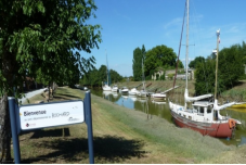
The port of Richard, like most of the small ports of the mattes of the lower Medoc, was created between 1850 and 1880, on the outlet of the drainage channels following the dyking of the mattes, ordered from the Dutch engineers by Henry IV.
Numerous lighthouses also saw the light of day during this same period, including one built in 1845 at the northeastern tip of the access channel to Richard harbor. The construction work on the port of Richard, estimated at that time at around 20,000 francs, was carried out in the 1870s and financed almost exclusively by the municipality of Jau-Dignac and Loirac.
Very flourishing commercial activities developed there in the 19th and early 20th centuries, particularly with the English, the Dutch and the Belgians around the sale of wine and cheese. Larger ships coming from abroad could not access the port of Bordeaux. They loaded their cargoes into gauges (shallow draft boats). The port of Richard thus acquired at this time its letters of nobility.
In addition, with the development of oyster culture from 1855, the port of Richard, like that of Goulée, became a platform for the preparation and transfer of spat, young oysters caught in the estuary to then be reared in the Bassin d'Arcachon.
From 1930, after the capsize of the Portuguese oyster cargo from the "Morlaisien", a steamer coming from the Tagus, this new species settled down and succeeded in developing on the estuary foreshore. Oyster farming thus supplants other port activities and remained very important until 1979, when the marketing of oysters was banned following pollution of the estuary from the Lot, in the Decazeville area. Since then, nature has been able to take back its rights and spat collection is again authorized in the estuary.
Sources : https://www.jau-dignac-loirac.com/France-Gironde-Jau-Dignac-Loirac-TOURISME.html
https://www.jau-dignac-loirac.com/France-Gironde-Jau-Dignac-Loirac-VILLAGE.html
VI.History
Middle Ages:
From the 6th century, the development of Christianity in the villages led to the foundation of rural parishes, around a church and a cemetery. This is how the three old parishes were formed.
The oldest is that of Jau, dedicated to Saint Peter towards the end of the 7th century. Two other parishes, that of Dignac dedicated to Saint Peter and that of Loirac dedicated to Saint Romain, separated from this primary parish between the 8th and 10th centuries.
In the village of Goulée, the Chapel of Saint-Siméon 3 was erected during the 13th century, on the site of an archaeological site whose occupation dates back to the Gallo-Roman period.
In 1599, Henry IV, by a royal edict, entrusted the Flemish Bradley with the systematic sanitation of the marshes of Bas-Médoc. However, it was the Duke of Epernon, Sieur de Lesparre and new owner in 1633 of the Sirie de Loirac who, during the 17th century, with the help of the Flemish Alsen, Gorie and Batten, gave real impetus to the work undertaken...
French Revolution and Empire:
After the revolution, by decree of the Constituent Assembly of October 14, 1790, the local structure was reorganized, the municipality replaced the parishes.
From 1791, the three old parishes were then united in a single municipality: “Jau-Dignac-et-Loirac”, with the election of a common mayor. If this reunification proves to be beneficial in many areas, there remains however a “parochial” spirit.
During this time, with the support (in particular financial) of Archbishop Donnet (who will become Cardinal in 1852) and the connivance of the majority of the municipal councilors, the Loiracais exceed their right. They demolish their church and undertake the construction of a larger church, at the junction point of the three old parishes, with the ulterior motive that it becomes the branch church, therefore the main one.
Contemporary period:
In 1844, this church was completed, but the new municipal council did not authorize the practice of worship there. All the civil and religious authorities want to put an end to these parochial quarrels, especially since a part of the population is not hostile to the project of this central church.
On the proposal of the Archbishop, the Ministry of Public Education and Worship, decreed on March 25, 1850, that the church of Loirac be erected as a branch, a vicar is appointed and worship is authorized there. By a new decree of June 21, 1852, the churches of Jau and Dignac were suppressed and on January 3, 1854, the Commission des Monuments Historiques allowed their demolition. The cemeteries of the three churches are abandoned but kept in place to respect the wishes of the families. Jau-Dignac-et-Loirac then forms a single municipality with a single parish. This central church is placed under the invocation of Saint Paulin de Nole. The furniture of the old churches is transported there and the bells of the three old parishes are reassembled in the bell tower. This bell tower served as the top of a triangle for the establishment of the staff map in 1864 and it was the bells of Jau-Dignac-et-Loirac that rang in the Médoc at the end of the last world war.
VII.Other information
The photovoltaic park project is progressing
Considering that the purpose of the revision project is to create a building zone with an area of about 6.1 hectares southwest of the village to allow the installation of a photovoltaic power plant in ground.
Sport and Handicap is possible!
Launch of the "Sport and Handicap is possible" week The clubs labeled "Handi-valid" in the Gironde region offer open-door slots during the week of October 12 to 18, 2020 for people with disabilities.
Wealth of the town
The buildings mostly built between the 18th and 19th centuries underline the importance of this period for our village.
Indeed, the reunification of the three parishes favors the establishment of new buildings, such as the church, the town hall, the school or the presbytery.
Here is the list of the most remarkable sites in the town:
* Richard's Lighthouse
* The 18th century church, Empire style
* The set of 18th and 19th century houses
* The Poulards mill (beautifully restored by an individual)
* The archaeological site of the Chapel
* The monumental crosses
Sources: https://www.jau-dignac-loirac.com/
https://www.jau-dignac-loirac.com/France-Gironde-Jau-Dignac-Loirac-TOURISME.html
http://www.mrae.developpement-durable.gouv.fr/IMG/pdf/kpp_2020_9726_r_cc_jaudignacloirac_33_d_mee_signe.pdf
VIII.Contact information
Jau-Dignac-et-Loirac town hall address :
Jau-Dignac-et-Loirac town hall
20 rue de la Mairie
33590 Jau-Dignac-et-Loirac
Mayor : Christian Boura (Mandate : 2020-2026)
Mail: mairie.jdl@orange.fr
Phone number: 05 56 09 42 12
Fax: 05 56 73 98 26
Website : http://www.jau-dignac-loirac.com
Sources : http://www.cartesfrance.fr/carte-france-ville/33208_Jau-Dignac-et-Loirac.html#mairie
