Frontenac, Gironde, Nouvelle-Aquitaine 作者: 来源: 发布时间:2021-09-23
I.Population and Area
Total Area: 14.4 km2
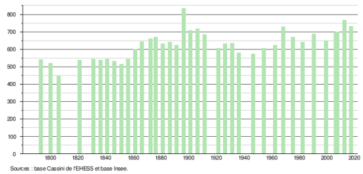
Population in 2017: 731
Population Density: 51 /km2
Histogram of demographic change
II.Natural Geography (environment and resources)

Frontenac is a town in southwestern France, located in the Gironde department, in the Nouvelle-Aquitaine region.
Located in Entre-deux-Mers, the town is separated from its neighbor Cessac by a stream, the Engranne, which flows further north in Saint-Jean-de-Blaignac, in the Dordogne. An eventful landscape carved out by the Engranne and its small tributaries, with a diversified vegetation of woods, still fairly developed viticulture, the charm of Entre-deux-Mers.
The town is located 42 km south-east of Bordeaux, capital of the department, 25 km north-northeast of Langon, capital of the arrondissement and 10 km east of Targon, chief -location of canton.
The neighboring municipalities are Blasimon to the north-east, Sauveterre-de-Guyenne to the south-east, Daubèze to the south, Martres to the south-south-west, Baigneaux to the south-west, Cessac to the north-west and Lugasson to the north.
The main road communication route is the D231 departmental road which crosses the village and leads north-northeast to Rauzan and south-west to the D671 departmental road, former national road 671 (Baigneaux, Bellebat then Rauzan towards the north-west and Saint-Brice and Sauveterre-de-Guyenne to the east-south-east), (then to Cantois; the departmental road D236 which leads west to Cessac and north-east to Blasimon; to the west, the departmental roads D123e10 then D123e11 lead to Sallebruneau then to the departmental road D670, former national road 670 (Rauzan, Saint-Jean-de-Blaignac then Libourne to the north and Sauveterre-de-Guyenne then La Réole to the South).
The nearest access to the A62 (Bordeaux-Toulouse) motorway is number 2, known as Podensac, which is 25 km to the south-west.
Access no 1, called de Bazas, to the A65 motorway (Langon-Pau) is located 39 km to the south.
The closest access to the A89 motorway (Bordeaux-Lyon) is from the motorway interchange with the national road 89 which is 25 km to the north-west.
The closest SNCF station is Caudrot, 21 km away by road south, on the Bordeaux-Sète line of the TER Nouvelle-Aquitaine. On the same line but offering more opportunities for connections, La Réole station is 23 km by road to the south-west and Langon station 25 km to the south-east.
The Libourne station on the TGV Atlantique Paris - Bordeaux line, the Intercités line Lyon - Bordeaux line and the TER Nouvelle-Aquitaine network is 27 km away by road to the north-west.
III.Economy
Employment rate (%): 77.8 (2017)
Average employment income (€):1 687 net per month (20 244 net per year)(2018)
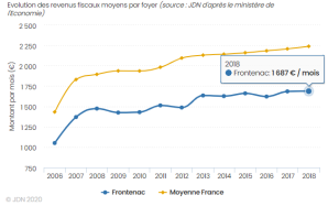
Evolution of average monthly net wages
Sources : http://www.journaldunet.com/business/salaire/frontenac/ville-33175
https://insee.fr/fr/statistiques/2011101?geo=COM-33175
IV.Industrial Characterisitics
Frontenac today has a wine vocation, but has experienced strong activity around the extraction and working of stone, which has made its reputation. Crossed by three streams that cut into the limestone plateau of Entre-deux-Mers, this town, rich in vestiges from prehistoric times to the present day, offers wooded valleys suitable for outdoor sports, equidistant from Langon, Libourne, la Réole, Bordeaux, Marmande, Ste Foy.
The Gironde stone
The stone of Gironde, whether it is from Bourg, Saint-Macaire, or Frontenac offers a remarkable variety of colors. It has always been exploited by man, so that even today, there are many galleries testifying to the important activity of quarrymen.
The stones of Frontenac were cut one by one by hand and were then transported by train to the construction sites of Bordeaux. Ensuring a good waterproofing of the walls, they are used as well for the facades of the houses as for anchoring the piles of bridges and the banks of rivers. So you can find stones from Frontenac throughout old Bordeaux and in many churches.
Today, the activity continues but in a very mechanized way. The extraction is now carried out with an open quarry. First of all, a working face is made, then a cutter chopper of enormous blocks which will be cut into more manageable slices. Each slice will later be cut in utilitarian dimension stone.
Sources: http://www.frontenac.eu/village.html
V.Attractions
1. Sallebruneau Commandery
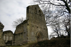
The Commanderie de Sallebruneau is located in the Gironde department about forty kilometers south-east of Bordeaux, in the Entre-deux-Mers region, in the town of Frontenac.
Description: The Saint-Jean chapel and the fortifications are from the thirteenth century, altered in the fourteenth century. The whole is placed on a feudal motte. The building is fully listed as a historical monument by decree of December 22, 1987. In summer, shows take place on this site, and restoration work should allow a wider reception. So there are conservation and restoration projects, volunteer internships (stone cutting, pointing, surveys), and guided tours of the site.
History: The commandery was founded in 1214 by the Templars, at that time there was only one church . In 1280, the commander is the knight Jean de Greilly, lord of Benauges and Castillon, who undertakes that year to donate the commandery to the Hospitallers of the Order of St. John of Jerusalem upon his death. However, without waiting for this deadline, the donation is effective and validated in a Charter of 1297, Jean de Greilly voluntarily cedes the jurisdiction of Sallebruneau to his friend Guillaume de Villaret, who then became Grand Master of the Order. Then in 1477, the district of Sallebruneau was attached to that of Bordeaux, in order to protect it from attempts to recover by force, by the lords of Rauzan, then hostile to the Knights of Saint-Jean. This rivalry will span several decades. Then the lands of Sallebruneau were devastated during the Wars of Religion, and the castle put in ruins.
The commandery included a church, a castle, and a garden of medicinal plants. It gradually increased by various donations from the lords of the neighborhood: the land of Buxs in 1280, the Frontenac mill and the territory of La Motte-Lucran in 1283. The spiritual seigneury of Buch and Mauriac also depended on Sallebruneau, as well as strongholds located at Aubèze, Frontenac and Saint-Léger.
A single rectangular nave separated from the choir by an arch falling on small columns. Only the ends (bases and capitals) remain of these. The apse is flat and has three semicircular windows which brought light into the choir. It is supported by three buttresses, the one in the middle being in the axis and therefore receiving the central window. The gable bell tower has two very wide bays. This church was used in the 19th century as a parish church.
It leans against the chapel and has roughly the same dimensions as this one. Its main feature is the square tower located to the northwest. It had two floors with cruciform archers included in the defense system of the commandery. On the ground floor, we see a small vaulted room which probably served as a jail.
2.Notre-Dame de Frontenac Church
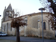
Notre-Dame Church is a Catholic church located in the commune of Frontenac, in the Gironde department, in France.
The building, whose construction dates back to the sixteenth century, is fully listed as a historical monument by decree of November 21, 1925.
3.Sainte-Presentine Church in Frontenac
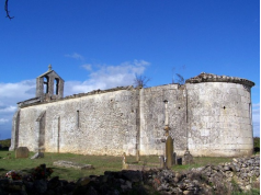
The Sainte-Presentine Church is a Catholic church located in the commune of Frontenac, in the department of Gironde and the natural region of Entre-deux-Mers, in France.
The church is in the middle of the fields, near a small road between Martres (to the west) and Daubèze (to the east).
From Frontenac, the church can be reached by the D123e10 departmental road, known as the Sauveterre road, towards the west and at about 500 meters, an arrow indicates the direction of the church towards the south, by the road known as Sainte- Presentine; the church is 2.8 km away.
The building, the construction of which dates back to the 12th century and which was the parish church of Sallebruneau (a town attached to Frontenac in 1965), is fully listed as a historical monument by decree of July 2, 1987.
VI.History
The commune of Frontenac, east of Targon, well known for its important freestone quarries, was formed by the reunification of the former parishes of Frontenac and Sallebruneau (dependency of the Knights of Malta, owners of the castle). It owes its name to a Gallo-Roman owner, "Frontenius". It was occupied very early on, as evidenced by the dolmens and the megalithic covered alley of Bignon, the troglodyte silos of Pique-Poche, the remains of a 2nd century villa near the church and the numerous Merovingian burials. up to date on the territory.
During the Revolution, the parish of Notre-Dame de Frontenac formed the municipality of Frontenac, the parish of Saint-Jean de Sallebruneau formed the municipality of Sallebruneau and the parish of Sainte-Presentine, annex of Saint-Sulpice de Daubèze, formed the municipality of Sainte- Presentine. On April 5, 1813, the commune of Sainte-Presentine was attached to that of Sallebruneau. On June 13, 1965, the commune of Sallebruneau was attached to that of Frontenac.
After the Revolution and its reshuffles, administrative and private fortunes, by the sale of national property, the identity of the municipality made up of the hesitant regrouping of several parishes, was finally established in its current plan. The economy in the nineteenth century obtained a lot of a railway line built especially to use local stone, much appreciated for the expansion of the Bordeaux conurbation, but also the monuments and properties of the region, and including in their current repairs.
In the twentieth century, as in other neighboring towns, the underground quarries dug in the limestone for the extraction of stone, or for this specific purpose, allowed a semi-industrial activity of cultivation of “Paris” mushrooms. For example, one of these operations employed up to 400 people before the 1970s. This culture then became extremely rare in France and therefore left only memories, nobody now venturing into these terrestrial bowels, which however allow the survival of bats, animals often endangered.
The railway line was gradually decommissioned in the 1960s, and became, to everyone's satisfaction [not neutral] a cycle and pedestrian path, called the Lapébie track, almost congested by locals and tourists.
Recent economic developments have reduced the liveliness of a town which, at its peak of activity, had up to 35 shops or crafts. But improving communications with Bordeaux via the Creon road stopped and even reversed the rural exodus.
The current commune of Frontenac is the result of the merger in 1965 of the communes of Sallebruneau and Frontenac. The former commune of Sallebruneau was born during the Revolution from the reunion of the parishes of Sainte-Presentine and Sallebruneau. This explains the presence of three churches on the municipal territory, but those of Sallebruneau and Sainte-Presentine are ruins.
The first traces of a human presence in the town date back to prehistoric times with a few rare remains from the Paleolithic and especially with the remains of a covered alley located in Bignon and dated to the Neolithic. These prehistoric finds are to be attributed to Abbé Labrie, priest of Frontenac and pioneer of prehistory at the end of the 19th century and at the beginning of the 20th century (a plaque placed on the south wall of the church gives him back tribute). The Gallo-Roman period yielded several sites attesting to an occupation: at Chollet, Sainte-Presentine and under the current Church of Frontenac. It was surely at this time that the name Frontenac was born. The absence of archaeological excavations does not allow us to specify the dating of these remains. At the end of Antiquity, Christianization took place and a first place of worship was created around the Church of Frontenac, as evidenced by the discovery of a Merovingian tomb in 1988.
The life of men in medieval times and until the French Revolution is organized in a parochial setting, with an old primitive parish around Frontenac or Sainte-Presentine. The parish of Sallebruneau was created later, around the year 1100, probably by the order of the Hospitallers of Saint John of Jerusalem (later called the Order of Malta) who established a seigneury on the territory of this parish. The other two parishes then depend on different lords: the parish of Frontenac depends on the seigneury of Rauzan, that of Sainte-Presentine on the seigneury of Benauges. In Sallebruneau, the soldier monks built a commandery attached to the 12th or 13th century church.
The destruction of the Hundred Years War necessitated repopulating the whole of Entre-Deux-Mers: the territory of the municipality of Frontenac is no exception. Several localities recall the names of these families who came to settle in the second half of the 15th century (Chollet, Tiffaut, Garineau).
Since antiquity, the main activity of men has been agriculture, based on a mixed crop combining cereals, vines, a little livestock and forestry. Some craftsmen were also present such as weavers, blacksmiths. Cereal activity has largely disappeared nowadays, but the presence of numerous mills attests to the importance of cereals in everyday life until the 19th century. The watermills, mostly dating back to the Middle Ages, are installed on the streams of Engranne (Bachon, Hauteroque) or Gourmeron (Chollet, Lassijan) or Coussillon (Garineau). There is also the memory of a windmill, later, which gave its name to a locality in the town. The toponym of Milha, for its part, recalls cereal production.
Sources:http://www.frontenac.eu/village.html
VII.Other information
Tourism: The remarkable sites of Frontenac
Our municipality has several remarkable sites worthy of being known to all! Here is a brief presentation. More information will be given to you at the Town Hall or at the Targon tourist office. Good visit !
La Lirette, its climbing walls and woods
This natural wooded site crossed by the Engranne provides walkers and athletes with numerous paths, picnic tables, a basketball court but also beautiful climbing walls, one of which is 15m high. Formerly a quarry then a municipal landfill, it is now accessible to everyone.
In the interest of all and by municipal decree, motorized vehicles are prohibited on the site (parking is available).
The Commandery of SALLEBRUNEAU
This former hospital commandery founded in 1214 by the Templars is classified as a historical monument since 1987. Every summer, restoration projects allow this magnificent building to gradually regain its former appearance. A pretty medieval garden awaits you for a free or guided visit (see the RAG).
The communal wash houses (Petit MILHA, GARINEAU, SAUVIOLLE and CHOLLET)
Proud of their history, they are enthroned in 4 localities in the village.
The Roger LAPEBIE cycle path
The railway line was gradually decommissioned in the 1960s and turned into a cycle path linking BORDEAUX to SAUVETERRE-DE-GUYENNE. Almost bottled on sunny days, it is a delight for young and old!
Notre-Dame church
In the center of the village, the building, whose construction dates from the 16th century, is listed as a historical monument since 1925. A mass is dedicated to it every 5th Sunday of the month.
The Sainte-Presentine church
The building, whose construction dates back to the 12th century and which was the parish church of Sallebruneau (a town attached to Frontenac in 1965), is fully listed as a historical monument by decree of July 2, 1987. Romanesque in style, it is unfortunately in ruins today.
The rivers of the town
Frontenac contains about 6.5km of waterways, Mainly the ENGRANNE (2.3km) and the GOURMERON (4.2km).
Hiking circuits
3 signposted loops exist in the town of Frontenac.
For the moment, the beacons are there but the circuit plans are in progress achievement at the General Council. When we will receive them, the cards will be available at the Town Hall.
In the meantime, you can still you venture to travel our beautiful paths campaign and try, thus, to reconstitute these 3 loops:
- The Gourmeron loop,
- The Commanderie loop
- The Motte loop
Note: no hiking on some paths between 1/10 and 11/11.
Sources: http://www.frontenac.eu/page17.html
VIII.Contact information
Frontenac town hall address :
Frontenac Town Hall
1 place of 19-March-1962
33760 Frontenac
Mayor : Josette Mugron (Mandate : 2014-2020)
Mail: mairie.frontenac@wanadoo.fr
Phone number: 05 56 23 96 38
Fax: 05 56 23 41 33
Website : http://www.frontenac.eu/
Sources : http://www.cartesfrance.fr/carte-france-ville/33175_Frontenac.html
