Fontet, Gironde, Nouvelle-Aquitaine 作者: 来源: 发布时间:2021-09-23
I.Population and Area
Total Area: 7.67 km2
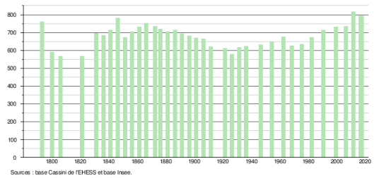
Population in 2017: 793
Population Density: 103 /km2
Histogram of demographic change
II.Natural Geography (environment and resources)
Fontet is a town in southwestern France, located in the Gironde department, in the Nouvelle-Aquitaine region.
Geography: The town of Fontet is located south-west (left bank) of the Garonne, 64 km south-east of Bordeaux, capital of the department, 19 km east of Langon, capital of the arrondissement , and 4 km south of La Réole, capital of the canton.
Bordering municipalities: The neighboring municipalities are La Réole to the north (Rouergue district), Hure to the south-east, Noaillac to the south, Loupiac-de-la-Réole to the west and Blaignac and Floudès to the north-west. To the east, on the right bank of the Garonne, is the town of Bourdelles.
Communications and transport:
The municipal territory is crossed by the departmental road D 9 which leads, towards the north-west and near La Réole, to the departmental road D 1113 (former national road 113, Bordeaux-Marseille) and, towards the south, to the The A62 motorway then allows you to reach Bazas to the south-west or Grignols to the south-east by the D 10 departmental road; the borough itself is crossed, on the one hand, by the departmental road D 9e6 which allows to join La Réole to the north and the said D 9 to the south and, on the other hand, by the departmental road D 225 which leads towards from Puybarban to the west and beyond towards Langon by the D 224 departmental road; the said departmental D 224 extends to the west of the village in the direction of Meilhan-sur-Garonne.
The nearest access to the A62 (Bordeaux-Toulouse) motorway is No. 04, called de La Réole, which is 6.5 km to the south.
Access no.1, known as de Bazas, to the A65 motorway (Langon-Pau) is 25 km to the south-west.
The closest SNCF station is La Réole, on the Bordeaux - Sète line of the TER Aquitaine, located 2.5 km to the north.
Hydrography:
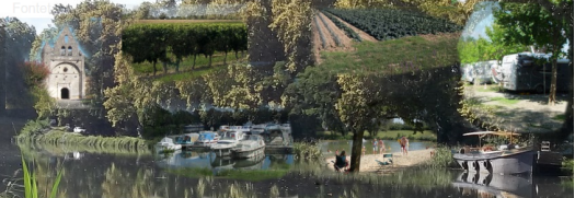
The town is crossed from east to west by the Garonne canal.
With the exception of the area to the south of the canal, the municipal territory, like the surrounding municipalities located between the Garonne and the Garonne canal, is almost flat. It is classified in the red zone under the flood risk prevention plan (PPRI). Dikes to protect against the floods of the Garonne crisscross it.
III.Economy
Employment rate (%): 72.7 (2017)
Average employment income (€):1 887 net per month (22 644 net per year)(2018)
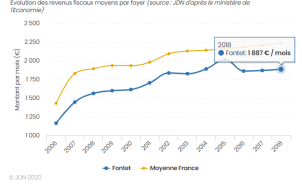
Evolution of average monthly net wages
Sources : http://www.journaldunet.com/business/salaire/fontet/ville-33170
https://insee.fr/fr/statistiques/2011101?geo=COM-33170#chiffre-cle-5
IV.Industrial Characterisitics
Sectors of activity most represented in Fontet
The table below lists the five activity sectors with the most companies in Fontet during the period from 24/09/2019 to 24/09/2020 as well as the share of each sector on the total number of 'enterprises of the municipality.
Sector of activity | Number of companies | Share of companies |
Rental and operation of own or leased real estate | 34 | 26.8% |
Non-permanent crops | 13 | 10.2% |
Finishing work | 8 | 6.3% |
Activities of other membership organizations | 5 | 3.9% |
Permanent crops | 4 | 3.1% |
The companies that generate the most turnover in Fontet
The list displayed below presents the companies based in Fontet and which report the highest 2019 turnover in the municipality.
1)Entreprise Silomi SARL
Entreprise Silomi SARL:
ENTREPRISE SILOMI SARL, a limited liability company, has been active for 43 years.
Based in FONTET (33190), it is specialized in the activity sector of current earthworks and preparatory works. Its workforce is between 3 and 5 employees.
In 2019 it achieved a turnover of € 413,500.00.
The balance sheet total decreased by 20.86% between 2018 and 2019.
Societe.com lists 4 establishments and the last notable event of this company dates from 23-04-2008.
Denis GALMAN, is manager of the company ENTREPRISE SILOMI SARL.
The vineyards - Wine tourism :
In Fontet, you are at the gates of the Entre Deux Mers, a triangle delimited to the south by the Garonne and to the north by the Dordogne.
Modeled in clay-limestone and gravelly clay soils, or even nestled in pockets of boulbènes (old alluvial soil), the terroirs produce white, red, rosé and clairet wines. Without having the fame of their Sauternes neighbors, the mellowness of the Première Côtes de Bordeaux and the sweet of Cadillac, Loupiac or Sainte-Croix-du-Mont, are nevertheless small wonders accessible to all.
Obviously, do not deprive yourself of tasting its wonderful and famous sweet wines nearby. In this land, in the Châteaux of Malromé and Malagar, lived Toulouse Lautrec and François Mauriac.
Sources: http://entreprises.lefigaro.fr/fontet/ville-33170
https://www.societe.com/societe/entreprise-silomi-sarl-308985134.html
V.Attractions
1. Church of Saint-Front de Fontet
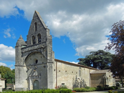
Saint-Front Church is a Catholic church located in Fontet, France.
The church is located in the French department of Gironde, in the town of Fontet, north of the village.
Built in the thirteenth century and endowed with a remarkable bell tower-wall, the building was enlarged in the sixteenth century with two apsidal chapels in Gothic style; it was listed as a historical monument by decree of December 24, 1925 in its entirety.
The partly Romanesque church has a 15th century bell tower. It dominates the facade, facing west and pierced with a Renaissance door. Between the nave and the choir, two arches open onto the Gothic side chapels dating from the 15th and 16th centuries. Both have an altarpiece integrated into the wall. The north chapel is adorned with remains of frescoes and the south one is crowned with an emblazoned keystone. In the church there is an 18th century wooden statue of Saint Front. The church is listed in the supplementary inventory of Historical Monuments.
Approximate address from GPS coordinates (latitude and longitude):
24 Le Bourg Nord 33190 Fontet
Protected elements:
Church: registration by decree of December 24, 1925
Construction periods:
16th century, 17th century
2.Lock no 49 at Fontet
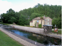
The Canal de Garonne (or canal lateral to the Garonne) is a navigable canal in the south of France which links Toulouse to Castets-en-Dorthe near Bordeaux. The work carried out under the supervision of Jean-Baptiste de Baudre in the nineteenth century includes many works including locks essential to the passage from reach to reach and canal bridges, two of which are among the largest in France.
3.Museum of Matches and Crafts
The Fontet museum reflects the inhabitants of its territory: artistic talents, various old and current know-how.
Museum volunteers have endeavored to showcase them through thematic exhibitions. They will happily guide you without being stingy with great stories and anecdotes during the visit.
Most of the space is given to unique works produced by an enthusiast of matchstick construction.
30 years that Gérard Gergerès cuts, deforms, glues these small pieces of poplar of a few centimeters to patiently build monuments, flowers, animals ...
Reproductions to scale but gigantic for some which reveal the talent of a true artist.
The museum also integrates, with great pleasure, many tools used in our countryside not so long ago and yet already fallen into disuse. With a very regional bias, our museum also integrates the works of local artists: sculptures, paintings, mosaics, etc. There are also some collections that you will discover on this site.
Our museum remains very humble in front of the monuments of Culture that we find in the cities and which are fortunately within the reach of the greatest number. However, we must keep in less mundane places the soul of those who one day built and fed cities: the peasants.
Useful information
Theme Collection:
Museum
Prices :
Adult: 5 €
Child: € 2.50
Hours :
From March 1 to September 30: every day from 2 p.m. to 6 p.m.
From October 1 to October 30 and from February 1 to February 29 only on Sundays and public holidays from 2 p.m. to 6 p.m., by appointment for buses and groups.
From November 1 to January 31: annual closure.
Group service: yes
Individual guided visit: yes
Individual guided tour on request: yes
source:
data.gouv.fr, Ministry of Culture (MUSEOFILE)
4.The canal of the two seas
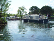
The canal des deux mers, also called the lateral canal to the Garonne, links Toulouse to Bordeaux. Built at the beginning of the 19th century, it was ultimately used very little for the transport of goods because the railway very quickly competed with it. It is now used by boaters.
The work covers 193 km. It is 18 m wide, 2 m deep, with a drop of 128 m. It has 53 locks. In Toulouse, it connects with the Canal du Midi.
In recent years, a cycle path has been built along the Canal: the green way.
Sources : https://www.gironde-tourisme.fr/patrimoine-culturel/eglise-saint-front-de-fontet/
https://monumentum.fr/eglise-saint-front-pa00083546.html
https://fr.wikipedia.org/wiki/%C3%89cluses_du_canal_lat%C3%A9ral_%C3%A0_la_Garonne
http://www.museeallumettes.com/
https://www.gralon.net/tourisme/musee-musee-des-allumettes-et-de-l-artisanat-1342.htm
http://www.fontet.fr/spip.php?rubrique82
VI.History
Fontet is a town in the southwest of France, located in the department of Gironde, in the Nouvelle-Aquitaine region.
The town of Fontet is located southwest (left bank) of the Garonne, 64 km south-east of Bordeaux, capital of the department, 19 km east of Langon, capital of the arrondissement , and 4 km south of La Réole.
The name of Fontet means "small fountain". The town indeed has a large number of water sources. The name of the town is Hontet in Gascon.
The original village of Fontet, was to be located on a feudal motte, in the current hamlet of Tartifume, north-east of the current village. It was mentioned in 1500. This feudal motte was located overhanging a bend in the Garonne. This natural elevation was part of the defensive ensemble of La Réole, with the Quat’Sos castle, the Castéra (motte to the south of the village) and the Blaignac charterhouse. Of this defensive situation, only ruins of walls and ditches remain today. From the medieval village, the architectural heritage of the church and some vestiges of the castle of Tartifume remain. A suspension bridge on the side canal of the Garonne is called the Tartifume suspension bridge, it is located just next to lock no 48. In the Middle Ages, pilgrims on their way to Saint-Jacques-de-Compostelle crossed the Garonne at ford of Tartifume. The Benedictines had the right to take the ferry at this location.
During the Revolution, the parish of Saint-Front de Fontet formed the municipality of Fontet.
The original village of Fontet, was to be located on a feudal motte, in the current hamlet of Tartifume, north-east of the current village. It was mentioned in 1500. This feudal motte was located overhanging a bend in the Garonne. This natural elevation was part of the defensive set of La Réole, with the Quat'Sos castle, the Castéra (motte south of the town) and the Blaignac charterhouse. Of this defensive situation, only ruins of walls and ditches remain today. From the medieval village, the architectural heritage of the church and some vestiges of the castle of Tartifume remain. A suspension bridge on the side canal of the Garonne is called the Tartifume suspension bridge, it is located just next to lock no 48. In the Middle Ages, pilgrims on their way to Saint-Jacques-de-Compostelle crossed the Garonne at ford of Tartifume. The Benedictines had the right to take the ferry at this location.
During the Revolution, the parish of Saint-Front de Fontet formed the commune of Fontet.
Sources: https://www.reolaisensudgironde.fr/communes/fontet/
VII.Other information
The vineyards - Wine tourism :
In Fontet, you are at the gates of the Entre Deux Mers, a triangle delimited to the south by the Garonne and to the north by the Dordogne.
Modeled in clay-limestone and gravelly clay soils, or even nestled in pockets of boulbènes (old alluvial soil), the terroirs produce white, red, rosé and clairet wines. Without having the fame of their Sauternes neighbors, the mellowness of the Première Côtes de Bordeaux and the sweet of Cadillac, Loupiac or Sainte-Croix-du-Mont, are nevertheless small wonders accessible to all.
Obviously, do not deprive yourself of tasting its wonderful and famous sweet wines nearby. In this land, in the Châteaux of Malromé and Malagar, lived Toulouse Lautrec and François Mauriac.
Also nearby, you will discover the coasts of Bordeaux Saint Macaire, the coasts of Marmandais (in Cocumont and Duras).
Town planning: SCOT Public Inquiry
PUBLIC SURVEY FROM NOVEMBER 4 TO DECEMBER 4, 2019
A public inquiry is organized to ensure the information and participation of the public and to collect their observations, proposals and counter-proposals relating to the Schéma de Cohérence Territoriale (SCoT) of South Gironde.
The Syndicat Mixte du SCoT du Sud Gironde is preparing an urban planning document entitled Schéma de Cohérence Territoriale (SCoT). The objective of SCoT is the organization of development and land use planning throughout the South Gironde for the next ten years. The development of the SCOT began with a territorial diagnosis validated in February 2014 and continues with the definition of a territorial project for the South Gironde by 2035
Public meetings Territorial Coherence Scheme (SCOT)
Four public meetings will be organized to present the draft Orientation Document and Objectives and collect the opinion of the population.
They will take place:
Tuesday January 22 at 6.30 p.m. at the CDC Convergence Garonne in PODENSAC;
Tuesday January 29 at 6.30 p.m. at the town hall of ST MACAIRE;
Wednesday January 30 at 6.30 p.m. at the St Romain room in SAUVETERRE DE GUYENNE;
Thursday January 31 at 6.30 p.m. in the BAZAS conference room.
For the record: The elected representatives of the South Gironde wished to have a Territorial Coherence Scheme. This town planning document built by all the elected officials of a territory makes it possible to determine a territorial project, bringing all sectoral policies (town planning, housing, travel, commercial facilities, etc.) into a coherent development logic. sustainable territory.
Inter-municipal Local Urban Plan
As part of the development of the Inter-municipal Local Urban Planning Plan, and following the deliberation of the Community Council on the definition of the terms of consultation with the population, it is recalled that a register is made available to the population in Town Hall (during opening hours to the public)
In this collection can be recorded any observations, remarks or suggestions concerning the future urban plan. It is also possible to send a letter to the attention of the Mayor. (for example: zoning modification request, network connection, etc.)
What is an intercommunal Local Urban Planning Plan?
The PLUi is an urban planning document at the level of a group of municipalities (EPCI) which studies the functioning and the challenges of the territory, constructs a development project respectful of the environment, and formalizes it in the rules of land use. It should allow the emergence of a shared territory project, consolidating national and territorial development policies with the specific features of the territory.
Sources: http://www.fontet.fr/spip.php?rubrique86
http://www.fontet.fr/spip.php?article541
http://www.fontet.fr/spip.php?article438
http://www.fontet.fr/spip.php?article475
VIII.Contact information
Cursan town hall address :
Cursan Town Hall
8 route du Gestas
33670 Cursan
Mayor : Jean-Pierre Seurin (Mandate : 2014-2020)
Mail: mairie@cursan.fr
Phone number: 05 56 23 06 29
Fax: 05 56 23 06 60
Website : http://www.cursan.fr
Sources : http://www.cartesfrance.fr/carte-france-ville/33090_Canejan.html
