Bègles, Gironde, Nouvelle-Aquitaine 作者: 来源: 发布时间:2021-04-06
I. Population and Area
Total Area: 9,96 km2 (3.84sq mi)
Population in 2017: 28 601
Population Density: 2 872/km2 (7448/sq mi)
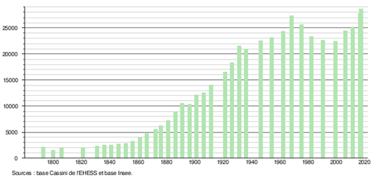
Histogram of demographic change
II. Natural Geography (environment and resources)

Bègles is one of the 28 municipalities that make up Bordeaux Métropole. Common first belt, it sits on the left bank and borders the Garonne by its eastern quarter.
On an area of 996 ha, Bègles benefits from 55 ha of public green space.
Topographic configuration: located south of the Bordeaux agglomeration, upstream on the Garonne, the territory is divided into two appreciably distinct topographical zones. The first as soon as you leave Bordeaux, to the west-southwest, forms elevations of land up to 11 meters above sea level, in a rather arid condition. The second, to the east, presents a wetland crossed by estes - streams which flow directly into the river and partly subject to the tides - along an east-west or east-south-west axis which constituted a marsh area. It is precisely this sense of "clay marsh" from the Garonne that the river called Eau Bourde, which winds south of the city, retains today.
The left bank of the Garonne is essentially formed of old marine sediments then alluvial. A 19 million year old stratum (lower Miocene - Burdigalian) shows a deposit of faluns; limestone sands rich in shells (as in Léognan). Another 3 million years (end of the Tertiary - Pliocene) offers a deposit of fawn sands, sometimes gravelly (grave of Bègles) and ferruginized. They are found from La Châlosse to the south of Bordeaux.
Geological formation: the terraces of fluvial origin are made up of deposits of sand, gravel and pebbles from the Garonne; they are covered by recent alluvial deposits made up of greyish clays and sands deposited to the north by EsteyMajou and to the south by Eau Bourde which are at the origin of deltaic systems identifiable on the 1/50 000 geological map edited by BRGM. The overflowing floods of the Garonne raised the alluvial rim and closed the outlet of these two rivers on several occasions, delimiting a triangular shaped area of influence, hence the Latin toponymBecula designating the space separated by the marshes of these two rivers. The low dip of the glacis and the impermeability of the soil also favored the formation of swamps.
III. ECONOMY
Employment income (%): 75.6 (2016)
Poverty rate by age group of the tax advisor(%): 13 (2017)
Average employment income (€):2 330net per month (27 963 net per year)(2014)
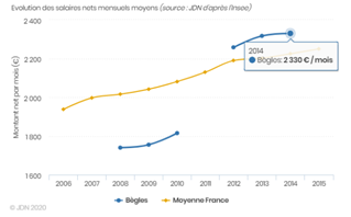
Evolution of average monthly net wages
Sources : http://www.journaldunet.com/business/salaire/begles/ville-33039
https://insee.fr/fr/statistiques/2011101?geo=COM-33039#tableau-REV_G1
IV. Industrial Characterisitics
Viticulture: Bègles is a wine-growing town in the Graves vineyard. On its territory, the AOC Graves, Graves Supérieur (sweet white only), Crémant de Bordeaux, Bordeaux Supérieur and Bordeaux4 wines are produced.
The Creative Economy Park:
The city of Bègles has been engaged since 1989 in an approach to the development of the territory through various Urban Renovation Operations. The reallocation of the TerresNeuves district as an economic hub is one of the most important projects. This former military wasteland, dubbed "TerresNeuves", has been home to audiovisual, communication and training companies since 2008.
Composed of 16 buildings over 4.2 hectares, in 2013 this site hosted more than 70 companies and nearly 750 permanent people, including 400 direct jobs (figures from March 2009). Some forty companies in the audiovisual production, entertainment, design and communication fields are already established (Wit FM radio, the 4 Design association, the Adams school, etc.). A 6,000 m² image center opened in September 2013, which includes a 400 m² film set as well as a post-production room.
The economic fabric of Béglais is made up of nearly 1,300 companies. 96% of them are SMEs or VSEs which employ less than twenty people. The city is also home to a dozen large companies, including a supermarket chain that employs nearly 500 people.
1. The activity of Gregoire revolves around two dominant poles:
1) the environment (Onyx, Astria, CUB treatment plant, etc.)
2) logistics (European Refrigerated Transport, Frigemar, Izaret, etc.). This last logistical vocation is reinforced by the presence of the Hourcade combined rail-road transport terminal. Ideally located between the ring road and the marshalling yard, this site, located in the territories of Bègles and Villenaved´Ornon, should generate new establishments of job-carrying companies.
2. Other sites in full development
Les TerresNeuves, built on former 4.5 ha military land purchased by the city. It essentially attracts companies that operate in the cultural, multimedia and communication sectors. Located a few hundred meters from the expressway (interchange n ° 21, near the Arcinsbridge) and Saint-Jean station. In February 2008, the “Terres-Neuves” tram station was inaugurated there. On the other side of the city, the activity of the river marina and of the area dedicated to businesses and businesses specializing in the nautical sector is developing.
Sources:https://www.mairie-begles.fr/86-revision-v1/
V. Attractions
1. Le Château de Francs (The Castle of Francs)
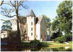
The castle of Francs, located in Bègles (Gironde), with its park and its surroundings classified as historic monuments.
The Château de Francs (12th century) is surrounded by a listed park since 1965 and by a monument to the additional inventory of historic monuments.
Not far from the so-called mote of Bègles, a 12th century feudal castle is built.
In the fourteenth century, it was rebuilt, fortified, embellished by ditches, gardens, fishponds and a mill on an estey (small stream flowing directly into the Garonne), arm of Eau Bourde, by the heirs of Bertrand de Ségur, lord of Bègles. The noble family of Ségur, allied with the Francs de Puynormand in Libournais, following the marriage in 1364 of Jeanne de Mayensan and Bertrand de Ségur is at the origin of the seigniory called Francs and Centujean. In 1565, we certify that the castle of Franks receives Charles IX and his court. The king is accompanied by a certain Henri de Navarre.
Major restoration in 1884. Former large wine estate. Private property.
2. Le port des Tuiles (The port of the Tiles)
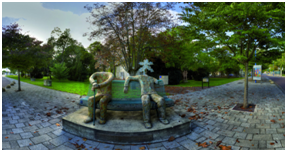
The Musée de la CréationFranche is a museum of raw and related art. Created in 1989 at the initiative of Noël Mamère on the proposal of Gérard Sendrey, it became a municipal museum in 1996.
"Frank Creation" refers to any artistic production by creators whose approach does not fit into institutional schemes. By "Frank" means stamped, autonomous, not subject (Maverick, free zone ...). This independence with regard to the systems in place does not less place the Frank Creation at the heart of the contemporary adventure, referring to a living art but developed at low noise; indeed, the creators in question here are fundamentally foreign to any search for recognition and indifferent to any form of notoriety. They have received no artistic training, have no knowledge of the arts, but in creating, they respond to an inner need.
The Musée de la CréationFranche has a collection of 19,000 works. It offers five exhibitions per year, among which “Visions and Creations Dissidentes”, the most important, presents eight new artists each year.
Very regularly approached by foreign museums, the Musée de la CréationFranche lends works that enrich international exhibitions or allow exhibitions dedicated to CréationFranche to be mounted.
He is also developing a small editorial activity (monographs, newsletter, etc.), all of which can be found on www.musee-creationfranche.com.
3. Église Saint-Pierre (Church of St. Peter)
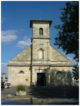
Church of St. Peter (from the 13th to the 16th century and 1830) located at Place du Général-de-Gaulle. The parish of Bègles was founded towards the life or the seventh century. The church under the protection of Saint-Pierre, patron saint of fishermen, was erected on the ruins of a Gallo-Roman temple by the Benedictines of Sainte-Croix de Bordeaux. The date 1491 is inscribed on the exterior wall. The building had a pointed bell tower dating from 1507, which has now disappeared. In 1790, the election of the first mayor of Bègles, Father Marc Daguzan, parish priest, took place in the church. It is one of the rare churches in France to bear the inscription "French Republic, Liberty, Equality, Fraternity" on its pediment. The facade dates from the 19th century, when the church was enlarged to double its surface.
Sources :https://www.mairie-begles.fr/musee-de-la-creation-franche/
VI. History
Bègles became the first industrial suburb of Bordeaux and the most populated until 1931. Three ports contributed to this development: the large port linked to the town by a street, today avenue du Maréchal Leclerc, the small port and the port Saint- Maurice. Its working and industrious population contributes to communal particularism; one is “from Bègles” or one is “very Bègles” seen from the condescending exterior.
During the First World War, two aeronautical factories set up in Bègles: Nieuport on the current quai Wilson and Louis Blériot which bought the Tartifume domain. An Eiffel type metal shed was built (rehabilitated in 2013). The neighboring land served as an airfield until 1952. The name of the Blériotbridge, which crosses the Bordeaux ring road, recalls this aeronautical past. In 1923 the Béglais Athletic Club (C.A.B.) began to make itself known by becoming rugby union champion of the Silver Coast. In 1928, a paper mill set up on the banks of the Garonne and specialized until 1960 in the manufacture of large capacity bags for a Bordeaux cement factory. Between 1925 and 1932, Alexis Capelle, socialist mayor of the city, adopted the project of building a swimming pool with baths-showers, the commissioning of which would mark the beginnings of public hygiene for the greatest number. The swimming pool, characterized by its Art Deco style, will become the oldest swimming pool in the Bordeaux conurbation and will be listed in the additional inventory of Historic Monuments. The era of the Popular Front marked Bègles in an original way, when on June 5, 1936 a tornado destroyed the grandstand of the Musard stadium. The Béglais will receive another shock four years later, with the installation of the German troops, in June 1940, on the agricultural grounds of Bègles which correspond to the current place des Martyrs-de-la-Résistance, in front of the office of post.
From 1959 to 1989, the city was ruled by the Union of the Left, bringing together communists, socialists, Christians, laymen and non-parties. During this period, the city implemented an important social program and acquired modern infrastructures typical of the sixties, housing, sanitation, retirement home, crèche, library. It builds holiday and leisure centers and makes early childhood and education its priority. The city distinguished itself in 1971, becoming the first municipality of the CUB to elect a woman mayor: Simone Rossignol. 1977 will mark the opening of the Gironde Postal Sorting Center, which will close on November 16, 2009.
In 1989, Noël Mamère was elected mayor of Bègles. Two years later, in June 1991, the CA Bordeaux-Bègles became champion of France in rugby by beating the Stadetoulousain at the Parc des Princes 19-10 in front of 49,370 spectators. On June 5, 2004, by a high-profile coup, Noël Mamère celebrated in Bègles the first gay marriage in France, finally invalidated by the authorities.
The urban reorganization of Bordeaux which has been taking place since the beginning of the 21st century also affects the municipality of Bègles, in particular with the development of tram lines. It was indeed on October 24, 2010, in pouring rain, at 10.51 am, that the city of Yves Farge (named after the resistance fighter, companion of Jean Moulin and Minister of Food in 1946) disappeared. This set of several social housing buildings (including four 14-story towers built in the sixties) saw its landscape definitively modified by the destruction of the last tallest building. Integrated into the new district called “TerresNeuves”, the disappearance of this building marks the end of an era.
The scope of the Bordeaux-Euratlantique project ISO concerns two Béglais sectors: Bègles-Faisceau (renovation of the Dorat district) and Bègles-Garonne.
VII. Other information
In 1989, the year in which Noël Mamère became Mayor of Bègles, the city embarked on its initiative in a political approach of "sustainable development".This orientation of public action was given long before the concept was consecrated in 1992 at the United Nations conference in Rio; long before this ecological necessity became obvious today unanimously claimed.Equipment and public spaces have therefore been thought out or rethought by integrating these concerns: ethical and organic purchases from central kitchens, cleaning up of pool water by plants, implementation of the 3 for 1 ecological upgrading plan (a uprooted tree, three replanted trees), revitalization of wetlands, cycle plan....
The city of tomorrow is built around an Urban Concertation:
45% of the territory of Béglais is under consideration (including 25% already changing). From north to south, from west to east, from TerresNeuves to Terre Sud, from the Environmental Intelligence Park to the Town Hall's Concerted Development Zone, Bègles is undergoing a metamorphosis. In 2015, line C of the tram will cross the town from north to south, irrigating along its route the districts crossed, and thus allowing the local economy to prosper.
Largely concerned by the Operation of National Interest, Bordeaux-Euratlantique, closely linked to the transformation process of the Bordeaux metropolis, at the gates of Bordeaux, surrounded by the Garonne and adjoining the future economic pole of Saint-Jean station, Bègles is a major territory, with multiple potentials and becoming full of promise.
But what will be the face of Bègles in 2030?
"Because the role of elected officials is to prepare for the future and to initiate policies that go beyond their mandate, it is necessary to project, today, what the face of Bègles will be in 2030 Faithful to its way of driving the urban development of the city, the municipality wants, again and again, to associate the Béglais in the construction of their future city. We are convinced: it is from the reflection and the words of the Béglais, steeped in their city, its history and its uniqueness, that the best ideas and working hypotheses will emerge to succeed Bègles 2030"--Noël Mamère, Deputy Mayor of Bègles.
By a decree of November 5, 2009, the State decided to create an operation of national interest for the overall development of the spaces located around Saint-Jean station. The project is called Bordeaux-Euratlantique.It will develop over an area of 738 ha spread over Bordeaux with 386 ha, Bègles with 217 ha and Floirac with 135 ha. The objective, by 2030, is to create a business center with international influence in these new districts. The construction of 2.5 million m² of space is planned, distributed between 150,000 dwellings and 500,000 m2 of offices. Shops and public facilities will complement these developments. In this context, the former sorting center on rue Jean-Jacques Bosc must be redeveloped into a Cité du Numérique, by the end of 201652 and the industrial wasteland belonging to ESSO must become an environmental intelligence park, from here 2020. Finally, the Simone-Veil bridge, designed by Rem Koolhaas and planned for 2020, will link Bordeaux and Bègles to Floirac in the continuity of the Bordeaux boulevards belt....
Sources :https://www.mairie-begles.fr/equipements/
https://www.mairie-begles.fr/7-revision-v1/
VIII. Contact information
Bègles town hall address :
Bègles town hall
77 rue Calixte-Camelle
BP 153
33321 Begles Cedex
Opening Hours of the town hall:
Tuesday to Friday: 8:30 a.m. to 5:00 p.m.
Monday: from 1 p.m. to 6.30 p.m.
Mayor :Noël Mamère (Mandate : 2014-2020)
Phone number: 05 56 49 88 88
Fax:05 56 49 32 85
Mail : contact@mairie-begles.fr
Website :http://www.mairie-begles.fr
Sources :http://www.cartesfrance.fr/carte-france-ville/33039_Begles.html#mairie
