Korfantów-Opole 作者: 来源: 发布时间:2021-10-22
Ⅰ. Population and Area
Population (2019-06-30)
• Total 1,808
• Density 180/km2 (460/sq mi)
Area
• Total 10.22 km2 (3.95 sq mi)
http://korfantow.pl
Ⅱ.Natural Geography (environment and resources)
-Korfantów is located in the Niemodlin Plain (Równina Niemodlińska), in the historical region of Silesia. The total area inside the town's boundary is 10,23 km².
-Transport
-Nearest Airport to Korfantów, Poland. Closest airport to Korfantów is Copernicus Airport Wrocław (WRO). Distance from Copernicus Airport Wrocław to Korfantów is 52.7 miles / 84.8 kilometers. Nice communication network, the proximity of the A4 motorway and the expansion of infrastructure have a positive effect on the sustainable development of these areas.
Ⅲ.Economy
-In the interwar period, there were 152 registered businesses in Korfantów, namely: services, trade and food production. After World War II, the town lost its former importance as the agricultural centre in the Nysa County. This was largely the effect of war losses, requisitioning, plunder and the Red Army's war commissar's rule over the locality in 1945, as well as poor political decisions. Later, the regime of the Polish People's Republic caused much impoverishment and financial instability, therefore, it was not until the reintroduction of the free market in 1989 that economic growth began to return. As of 2015, 52% of the Gmina Korfantów populace lives off the agricultural sector.
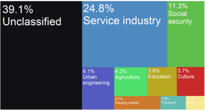
-Korfantów city budget income sources as of 2015
-Korfantów - Wikipedia https://en.wikipedia.org/wiki/Korfant%C3%B3w#Economy
Ⅳ.Industrial Characteristics
-Characteristics of the commune
-The Korfantow commune is a melting pot of cultures created by the inhabitants of this area, which constitute its history, present and future. However, the Korfantov land is not only a natural and cultural wealthy, it is also a constantly developing economic and cultural center. The economic base of the commune is also agriculture and wood management.
-Education, sport, recreation, health, agriculture - five important areas that define the strategic goals of the commune, and at the same time create a coherent offer for residents, visitors and tourists.
-It covers 180 km 2Korfantów commune, consists of 24 towns, including the town of Korfantów - the commune's capital - and the villages of: Borek, Gryżów, Jegielnica, Kuropas, Kuźnica Ligocka, Myszowice, Niesiewienowice, Piechocice, Pleśnica, Przechód, Przydroże Małe, Przydroże Wielkie, Puszyna, Rączka , Rynarcice, Rzymkowice, Stara Jamka, Ścinawa Mała, Ścinawa Nyska, Węż, Wielkie Łąki, Włodary and Włostowa. At the end of the fourth quarter of 2012, the commune was inhabited by 9,491 inhabitants - due to the remarkable history of this place, the population living in the Korfantów region is not homogenous in terms of ethnicity and culture. In the northeastern part, indigenous people, i.e. people of German origin, predominate. The remaining localities are dominated by the immigrant population from the eastern borderlands, and to a lesser extent from mountainous areas and central Poland.
-The most important economic entity, and at the same time important for the development of the Korfantow commune, is the Opole Rehabilitation Center in Korfantowo, which provides medical services in the field of, among others, orthopedic surgery or rehabilitation of the musculoskeletal system. Based on the specialized offer of this center, companies producing specialized orthopedic and rehabilitation equipment are also developing. The center is also an element of the recreational and health offer of the Korfantów region.
-Charakterystyka gminy - Urząd Miejski w Korfantowie https://korfantow.pl/1124/1219/charakterystyka-gminy.html
-Key projects
-1. The modernization of public utility and educational facilities in the Korfantow Commune
-The Korfantów commune has commenced the implementation of tasks aimed at thermal modernization of public utility buildings in the Korfantow Commune.
-Investments related to the thermal modernization of buildings will significantly reduce the operating costs of facilities and improve the efficiency of energy use.
-This project includes the implementation of thermal modernization in the following facilities:
-1. Building of the School and Kindergarten Complex, ul. 3 Maja 12 in Korfantów;
-2. Building of the School and Kindergarten Complex, ul. Klasztorna 4 in Ścinawa Mała;
-3. Kindergarten building ul. Ścinawa Nyska 59, in Ścinawa Nyska;
-4. Administrative building of the Municipal Office ul. Reymonta 4 in Korfantów;
-5. Administrative building of the Municipal Office Rynek 4 in Korfantów.
-Termomodernizacja obiektów użyteczności publicznej i oświatowych w Gminie Korfantów - Urząd Miejski w Korfantowie https://korfantow.pl/3536/2430/termomodernizacja-obiektow-uzytecznosci-publicznej-i-oswiatowych-w-gminie-korfantow.html
-2. Reconstruction of the road surface along with the pavement of ul. Cyprian Kamil Norwid in Korfantów
-On February 4, 2020, the Mayor of Korfantow commissioned Zakład Gospodarki Komunalnej i Mieszkaniowej in Korfantów to build the road surface in Korfantów, ul. Cyprian Kamil Norwid from a concrete block, thickness: 8 cm, 225 m long, on the area of 1,317 m² with a pavement made of concrete 8 cm thick on the area of 556.5m².
-On April 15, 2020, the construction site was handed over.
-Supervision inspector: INNTEST Company - construction services ul. Drzymały 8/1, 45-342 Opole, - PLN 2,460.00.
-Value of construction works PLN 316,994.01.
-The works were collected on June 16, 2020.
-Investment value: PLN 324,487.68
-Przebudowa nawierzchni drogi wraz z chodnikiem ul. Cypriana Kamila Norwida w Korfantowie - Urząd Miejski w Korfantowie https://korfantow.pl/6620/1689/przebudowa-nawierzchni-drogi-wraz-z-chodnikiem-ul-cypriana-kamila-norwida-w-korfantowie.html
Ⅴ.Attrations and Cityscape
-Black Staw in the Ligock Forge
-Czarny Staw - most likely it is the result of the extraction of peat and bog iron. About 150 years ago there were two other ponds nearby, one of which was called the Silver Pond. Today a forest grows in their place. It is situated in the Kuźnica Ligocka Forestry, among the areas of Bory Niemodlińskie, by the educational and cycling path "Skrajem former Puszcza".
-Wild Paradise fishery in Rzymkowice
-Rzymkowice - Recreational pond with an area of 2 ha and a depth of 2-6 m is located on the agritourism farm "Dziki Raj", located on the edge of the Bory Niemodlińskie forest.
-Zacisze ponds in Węże
-"Zacisze" ponds - are located near the village of Węż near Nysa, in the Korfantów commune. The two ponds on the agritourism farm will provide pleasure to those who are thirsty for fishing. You can catch there, among others. such species: carp, grass carp, pike, zander, tench, perch, crucian carp. It is an ideal place for those seeking peace and quiet away from the hustle and bustle of the city, who want to wake up every day to the singing of birds.
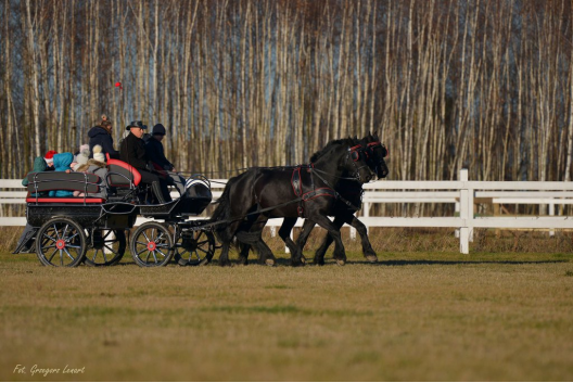
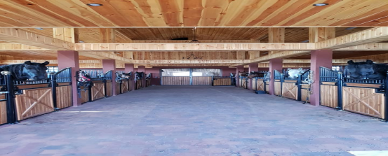
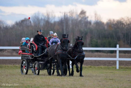
-Magnum stable
-We invite you to the newly opened Magnum Stable, located in Kuropas 17. The facility is located in the quiet of the village, away from the city noise, available to everyone, especially for people who want to spend time actively and pleasantly outdoors and with our horses. We have a paradise here for lovers of four-hoofed horses and for those who want to start their adventure in the saddle, regardless of age.
-Hours of operation: from 9.00 am until the last visitor.
-We offer:
-* tours on ponies and large horses
-* riding lessons for beginners
-* horse riding with an instructor
-* field trips
-* horse-drawn carriage rides
-* horse rental for photo sessions and special events
-* organization of birthdays for the youngest
-* hippotherapy classes with qualified hippotherapists
-* time spent in a family and friendly atmosphere
-tel. 785627551 Marlena Socha
-We invite everyone to visit and take advantage of our offer.
-Parish Church of St. Trinity in Korfantów
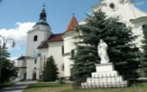
-It was built at the turn of the 13th and 14th centuries and rebuilt in 1909 in the neo-Gothic style. The following deserve attention:
-granite portal of the main entrance from the turn of the 13th and 14th centuries;
-tombstone from 1591;
-the tomb of Henryk Wacław Nowagek from 1682;
-the church tower from 1751;
-procession candlesticks from the 18th and 19th centuries;
-marble baptismal font from the 19th century;
-sculpture Christ Crucified from the 19th century;
-Parish Church of St. John the Baptist in Przechod
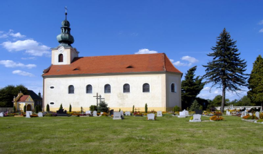
-The late Baroque building, mentioned in 1447, was given its present shape in 1779. The interesting interior and furnishings date from the reconstruction period.
Ⅵ.History and Culture
-The former name for the settlement was Hurtlanth or Hurthland. Other documents relate to the town as: Fredland, Fredelant, Fredlandt, Fridland, Freijland, Stadt Friedland and Friedland. Over time, the locality's Polish name was remodelled to its German counterpart, and was namely referred to as: Ferląd, Ferlondt, Frydląd, Fyrląd, and officially as Fryląd. After World War II, due to the town's German etymology, the settlement was renamed after Wojciech Korfanty.
-Until 1532 the area was in the possession of Polish princes of the Silesian Piast Dynasty. Simultaneously, an influx of German settlers caused the town to develop; it became the property of wealthy German and Silesian nobles. In 1632, the Swedes plundered Friedland and surrounding villages during the Thirty Years' War. Over the next decades the town also suffered due to plagues and fires. At that time, Friedland was part of the Kingdom of Bohemia within the Habsburg Monarchy. In 1645 it returned to Poland under the House of Vasa, and in 1666 it fell to Bohemia again, however, it was ceded to Prussia after Frederick II the Great emerged victorious in the mid-18th century Silesian Wars. In the 19th century, despite Prussian and German rule, Catholic services were still held in Polish alongside German.[4] It was part of Germany from 1871 until the end of World War II in 1945, when, under the Potsdam Agreement, it was reassigned to Poland. During World War II, the Polenlager 85 Nazi German concentration camp for Poles was based in the town in 1942–1943. A mass grave of its prisoners is located at the local parish cemetery.
-The City Council established the Korfantow Commune logo
-Ladies and Gentlemen, we are very pleased to announce that on January 27, 2016, during the 16th Session of the City Council in Korfantów, the logo of the Korfantow Commune was established.
-The logo in it refers to the coat of arms of the Korfantow Commune. There is the inscription Korfantów and a castle with three towers with a higher middle one in it. Logo of the commune - an original, simple and universal sign will strengthen the impact, and the graphic form used will allow for its faster and easier remembering. The use of the logo will make the Korfantow Commune stand out from others and will be recognized better than just by using its coat of arms.
-In addition to establishing the graphic appearance of the logo, there are also regulations for using it.
Ⅶ.Other Information
-Korfantów [kɔrˈfantuf] (German: Friedland in Oberschlesien), formerly known in Polish as Fryląd, is a town in the Opole Voivodeship of southwestern Poland, with 1,808 inhabitants (2019). In 1946 the town was renamed in honor of politician and activist Wojciech Korfanty, however, the previous name Fryląd is still in use.
Ⅷ.Contact Information
Mayor Janusz Wójcik
Tel: (77) 43 43 820
Fax: (77) 43 43 817
E-mail:korfantow@korfantow.pl
http://korfantow.pl
