Paczków- Opole 作者: 来源: 发布时间:2021-07-15
Ⅰ. Population and Area
Population (2019-06-30)
• Total 7,460
• Density 1,156.2/km2 (2,995/sq mi)
Area
• Total 6.6 km2 (2.5 sq mi)
Website http://www.paczkow.pl
Ⅱ.Natural Geography (environment and resources)
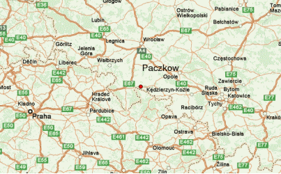
-The Paczków commune is situated in the south-western part of the Opolskie Voivodeship, in the Nysa poviat , on the extremely popular track from Nysa to Kłodzko, which is an element of the route connecting Silesia and Małopolska with the "tourist treasury" of Lower Silesia - the Kłodzko Valley.
-This exceptionally picturesque area is distinguished by interesting cultural monuments and numerous natural and sightseeing values, incl. diversified terrain, the vicinity of three water reservoirs (Lake Otmuchowskie, Lake Nyskie and Zalew Paczkowski) and the aforementioned proximity of the Kłodzko Land and the Sudetes.
-Transport
-To the west and north, Paczków borders with the Dolnośląskie Voivodeship (Złoty Stok commune, Kamieniec Ząbkowicki commune and Ziębice commune), in the east with the Otmuchów commune, and in the south with the Czech Republic. Two important communication routes intersect the commune's area. The first is the national road No. 46 (the so-called sub-Sudetic route), running from Częstochowa through Opole and Nysa to Kłodzko, while the second (provincial road No. 382) leads to the vicinity of Świdnica (through Ząbkowice Śląskie, it is possible to connect with the national road towards Wrocław).
-The seat of the commune is Paczków - a small town that was located by the Bishop of Wrocław, Tomasz I in 1254. The city has perfectly preserved its historical character and tempts tourists with many well-preserved monuments and a climate filled with medieval mystery.
-Examples of road distances to major cities in Poland:
-Opole - 80 km
-Wrocław - 90 km
-Katowice - 180 km
-Krakow - 260 km
-Poznań - 260 km
-Łódź - 275 km
-Warsaw - 392 km
-Szczecin - 485 km
-Gdańsk - 517 km
-Paczków and Europe (road distances):
-Prague (CZ) - 221 km
-Bratislava (SK) - 332 km
-Vienna (AUT) - 336 km
-Berlin (D) - 420 km
-Bern (CH) - 1032 km
-Paris (F) - 1,255 km
-London (GB) - 1470 km
-Madrid (E) - 2,540 km
-Stockholm (S) - 1490 km
-Nearest airports:
-Wrocław - Copernicus Airport (approx. 1 hour 30 min.)
-Krakow - Balice Airport (approx. 2 hours 40 minutes)
-Katowice - Pyrzowice Airport (approx. 2 hours)
-Nearest highway:
-A4 motorway - entry near Niemodlin (Prady) - approx. 60 km (approx. 1 hour)
Ⅲ.Economy
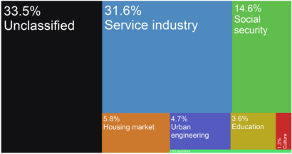
Paczków city budget's income sources as of 2015
-Infrastructure
-COMMUNICATION
-A well-developed road system enables access from the commune to the major cities of Silesia and Małopolska. Public passenger transport is carried out mainly by PKS buses and buses of private transport companies.
-There is one national road running through the commune - no. 46 - managed by the General Directorate for National Roads and Motorways / Opole branch. The road runs through the following cities: Kłodzko - Nysa - Pakosławice - Jaczowice - Niemodlin - Karczów - Opole - Ozimek - Lubliniec - Blachownia - Częstochowa - Janów - Szczekociny. It is a bituminous road and has the technical standard "G" class - the main road.
-The area of the Paczków commune is also crossed by two voivodeship roads marked with the number 382, which are managed by the Voivodeship Roads Authority in Opole. The road starts from the Polish border with the Czech Republic (crossing Paczków - Bily Potok) to the national road No. 46. The second part of the road No. 382 starts at the first exit from the national road No. 46 (near the PKN Orlen petrol station) and continues through Paczków , Ząbkowice Śląskie, Dzierżoniów, Świdnica, all the way to the village of Stanowice.
-The national road in the commune is 17 km long, the voivodeship road is 8 km long, the district roads are 37 km and the commune roads are 25 km.
-The railway line running through the commune is currently excluded from passenger traffic. The railway supports only freight transport, mainly mines of gravel and sand mineral resources and industrial plants.
-TELECOMMUNICATION
-Eight operators provide fixed-line services in the public telephone network in the area of the Paczków commune. 2,533 subscribers using the fixed-line services of the public telephone network are registered in them. The number of individual subscribers is 2,121, and the number of business subscribers 412. The
-average number of notifications about the lack of access to the telephone network per 10,000 households for the Paczków commune is 2.19.
-Four operators provide access to fixed broadband Internet in the area of the Paczków commune. Their services are used by a total of 874 subscribers, including 822 individual subscribers and 52 business subscribers.
-The area of the Paczków commune is fully covered by the range of four major mobile network operators (Era GSM, Orange, Play, Plus GSM). Access to the GSM network coverage is possible both outside and inside buildings. The Orange network and the Play network offer access to third-generation (3G) mobile telephony in the area of Paczków.
-ELECTRICITY
-The power grid in the commune is well developed and constitutes a uniform national system. The Paczków commune is supplied with electricity from the main power point of GPZ Paczków 110 kV / 15 kV located on the land of the village of Unikowice.
-The consumers are supplied with electricity through the medium voltage overhead main network, through transformer stations, and then through the low voltage overhead networks. In rare cases, cable lines ensure the supply of electricity directly to end users.
-Low voltage lines are generally led out of overhead transformer stations and are distributed along the streets and roads of individual villages and to colony consumers. The existing system of supplying the commune with electricity fully satisfies the existing demand for electricity.
-On Lake Paczkowskie, there is a hydroelectric power plant producing the so-called clean energy.
-NATURAL GAS
-The high-pressure gas pipeline from Otmuchów - Paczków Dn 100 with a nominal pressure of 4.0 Mpa runs through the commune area, along the national road No. 46.
-Only two towns use the gas pipeline: Paczków and Wilamowa.
-The total length of the gas distribution network is 17.2 km. Paczków is supplied with gas in 97%, while villages in 10%. Currently, the gas pipeline is used by 2,451 people.
-WODOCIĄGI AND KANALIZACJA
-The Paczków commune has a sewage system at the level of approx. 51% (the city approx. 90%). The length of the sewage network is 14.6 km. Currently, about 7,000 inhabitants of the city use the sewage system.
-Sewage treatment is handled by the Water and Sewerage Plant in Paczków, which operates one sewage treatment plant at ul. Moniuszko. Sewage flows to it through a sanitary sewer from the city. The sewage treatment plant with a capacity of 2,500 m3 / day, commissioned in 2000, receives approximately 1,350 m3 of sewage per day.
-The Nysa Kłodzka River is the receiver of wastewater from this treatment plant through a system of drainage ditches.
-Currently, the water supply system covers 100% of the area of the Paczków commune. Water supplies to the inhabitants of Paczków and the surrounding area are handled by the Zakład Wodociągów i Kanalizacji in Paczków. ZWiK operates three Water Treatment Stations (Paczków, Stary Paczków, Kozielno).
-AGRICULTURE
-The Paczków commune is an agricultural commune. Agricultural land in the commune covers 6,193 ha, which is over 80% of its area.
-In the area of the Paczków commune, well-kept class III and IV acidic soils with an increased demand for lime, moderately rich in phosphorus, poor in potassium, magnesium, molybdenum and boron prevail. The soils contain a high content of available magnesium, zinc and copper.
-The good quality of the soil and the low content of trace elements (Cd, Cu, Ni, Pb, Zn) at the natural level create the possibility of developing organic farming in the commune.
-Plant production dominates in the Paczków commune, mainly the cultivation of cereals, root crops, oilseed crops (rape) and hops. In addition, poultry, pigs and cattle breeding, as well as fish farming (in Gościce, Ujeździec and Trzeboszowice) are conducted in the commune. Unfortunately, most of the farms in the commune are small farms.
-Infrastructure - Town Hall in Paczków https://paczkow.pl/119/141/infrastruktura.html
Ⅳ.Industrial Characteristics
-The characteristics of the town of Paczków's economic dependence is similar to that of the Gmina Paczków and the whole of the Opole Voivodeship, agriculture. The gmina, under the local authority of the town has a total of 6193 ha used for agriculture (80% of its land), with the main crop being canola.
-To the west of Paczków, the Paczkowski Lake, while predominantly performing the role of protecting the locality from flooding, is also home to a small fishing industry. Apart from food production, Paczków is home to numerous heavy industry complexes, including the "EMSTEEL" steel plant by Robotnicza Street (ul. Robotnicza) and the "Pollena Paczków" chemicals manufacturing plant by Henryk Sienkiewicz Street (ul. Henryka Sienkiewicza). Withal, in 2015 the service industry (including manual labour) provided 31.6% (11.7 million złoty) to the city's budget.
-Key projects
-1. Waste Management Plan for the Paczków Commune
-2. Environmental Protection Program
-3. Local Program for the Revitalization of the City of Paczków until 2023
-Strategic documents - Town Hall in Paczków https://paczkow.pl/39/108/dokumenty-strategiczne.html
Ⅴ.Attrations and Cityscape
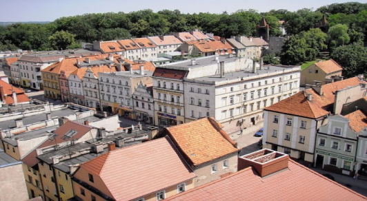
Paczków Old Town
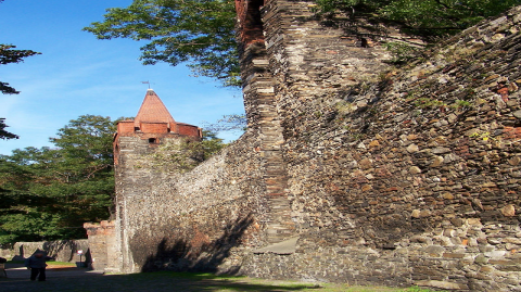
Medieval town walls
Medieval town walls
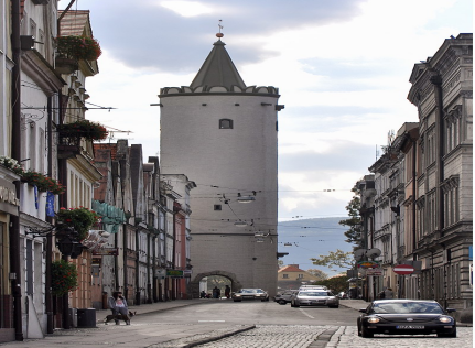
Kłodzko Gate
-Unlike nearby Nysa, World War II spared Paczków, and most of its monuments have been preserved. Called "The Polish Carcassonne" (or, before the town was reintegrated with Poland, "the Silesian Carcassonne"), as early as in the 15th century, it was surrounded by double ring of defensive walls. Initially, the fortifications were made of dirt and wood, but later they were replaced by mightier stone walls.
-The first fortifications of Paczków were built in the mid-14th century upon the order of the Bishop of Wrocław, Przecław of Pogorzela. In the mid15th century, Paczków had three gates - Wrocław Gate (Brama Wrocławska, eastern), Kłodzko Gate (Brama Kłodzka, western), and Zabkowice Slaskie Gate (Brama Ząbkowicka, southern). In the second half of the 16th century, the northern Nysa Gate (Brama Nyska) was added. Vertical, 9-metre walls made from stone still surround the historical centre of the town today. Altogether, the fortifications are around 1200 metres long, and apart from four gates, there originally were 24 wall towers, out of which 19 have been preserved. Along the defensive walls, there was a moat, which has been turned into a recreational park.
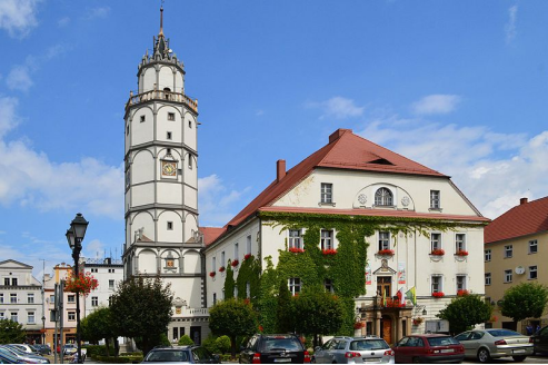
-Paczków Town Hall
-Besides its fortifications, Paczków is famous for renaissance, baroque, and neoclassic tenement houses, which surround the town square. The oldest of these buildings date back to around 1500, with the most visible being the so-called "House of the Executioner". Also, in the centre of Paczków, there is the town hall, with a 48-metre-high (157 ft) tower.
-Another interesting monument of "Polish Carcassonne" is the Church of John the Evangelist, which is considered to be one of the most impressive fortified churches in Poland. Its construction began in 1350, and lasted for 30 years. The unique Gothic church, which is made of stone and bricks displays a renaissance attic, and its mighty structure has been incorporated into the town's fortifications. The church stands out because of its immense size, and inside there are sculptures attributed to Wit Stwosz. Next to the complex there is the so-called Tatar well. According to a legend, a Tatar warrior (see Mongol invasion of Poland) was thrown into the well, after he had captured the daughter of a wealthy inhabitant of Paczków.
Ⅵ.History and Culture
-Paczków was officially founded and granted town rights on March 8, 1254, when the Polish Bishop of Wrocław, Tomasz I gave permission to two Flemings Henryk and Wilhelm, for the location of a new town Bogunów (mentioned under the Latinized name Bogunov) to be settled by German immigrants. The new town was placed near the ancient village of Paczków and took its name, and henceforth, the name of the village was changed to Stary Paczków ("Old Paczków"). The name Paczków itself comes from the Old Polish male name Pakosław. Paczków, mentioned in medieval documents under the Latinized Old Polish names Paczkaw (Liber fundationis episcopatus Vratislaviensis) and Patzkow (Book of Henryków), quickly grew, becoming not only a market town, but also a stronghold, guarding southwestern borders of the ecclesiastical Duchy of Nysa of fragmented Poland.[8] It was granted the so-called Flemish rights, based on Magdeburg rights. The new town received several privileges, such as the right to brew beer, and its early inhabitants were mostly craftsmen, such as bakers, butchers and shoemakers.
-In the Late Middle Ages and subsequent periods, Paczków shared the stormy fate of other towns of Silesia, with frequent disasters, such as hunger (1325), floods (1333, 1501, 1539, 1560, 1598, 1602), fires (1565, 1634), as well as epidemics - Black Death (1349), and cholera (1603–1607, 1633). The town also suffered during the Hussite Wars, when it was captured by the Hussites on March 17, 1428. The period of religious wars did not end until the late 15th century, and only then did Paczków begin to flourish again. With the financial support of the dukes of Nysa, new fortifications were constructed, with a wall and towers.
-In 1526 Paczków, under the Germanized name Patschkau, together with the Duchy of Nysa, passed under the suzerainty of the Austrian Habsburg dynasty. The town blossomed, as a major centre of trade, with several manufacturers of textiles. The end of prosperity came during the Thirty Years' War, when warring armies destroyed Patschkau and adjacent areas. In 1742, after the Silesian Wars, Patschkau was annexed by the Kingdom of Prussia, and it subsequently became part of the German Empire in 1871. It was secularized in 1810. The town was spared from serious destruction during World War I and II. During World War II, the Germans established five working parties (E158, E164, E274, E504, E534) of the Stalag VIII-B/344 prisoner-of-war camp in the town.[9] In the final stages of the war, the town was captured by the Soviet Red Army in May 1945. Its German population was largely evacuated or expelled. After the war, following the Potsdam Agreement, it became again part of Poland, and its Polish name was restored.
-The town was repopulated by Polish settlers from war-devastated Central Poland and expellees from former eastern Poland annexed by the Soviet Union, mostly from areas of Lwów, Tarnopol, and Volhynia (current western Ukraine).
Ⅶ.Other Information
-Paczków is a town in Nysa County, Opole Voivodeship, Poland, with 7,460 inhabitants (2019). It is one of the few towns in Europe in which medieval fortifications have been almost completely preserved. Located in the southeastern outskirts of the historical province of Lower Silesia, along the medieval road from Lesser Poland to Klodzko Valley and Prague, Paczków is called "Polish Carcassonne", thanks to its well-preserved medieval fortifications. However, while the famous French Carcassonne is a 19th-century reconstruction, all historic buildings of Paczków are authentic.
-The old town and its medieval fortifications are listed as one of Poland's official national Historic Monuments (Pomnik historii), as designated November 13, 2012. Its listing is maintained by the National Heritage Board of Poland.
Ⅷ.Contact Information
Government
• Mayor Artur Rolka
Website http://www.paczkow.pl
Phone: +48 77 431 67 91
Fax: +48 77 544 90 04
E-mail: um@paczkow.pl
