Głubczyce- Opole Voivodeship 作者: 来源: 发布时间:2021-07-16
Ⅰ. Population and Area
Population (2019-06-30)
• Total 12,552
• Density 1,017.5/km2 (2,635/sq mi)
Area
• Total 12.52 km2 (4.83 sq mi)
Website
https://glubczyce.pl/
Ⅱ.Natural Geography (environment and resources)
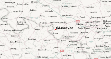
-Głubczyce is situated on the Głubczyce Plateau (Polish: Płaskowyż Głubczycki; a part of the Silesian Lowlands) on the Psina (Cina) river, a left tributary of the Oder. The town centre is located approximately 62 km (39 miles) south of Opole and just northwest of Ostrava.
-Transport
-There are:
-national road No. 38 of regional importance from Kędzierzyn-Koźle-Głubczyce to the state border
-Two voivodeship roads: No. 416 - Krapkowice-Głogówek-Głubczyce-Kietrz-Racibórz and No. 417 - Laskowice-Klisino-Szonów-Szczyty-Lisięcice.
-About 20 km from the city center, there is a national road from Pszczyna-Racibórz-Opole No. 45, which serves as the main accelerated traffic route. At a distance of 25 km in a straight line, but already on the Czech side, there is road No. 11 with a similar function in the relation Praha (Hradec Kralove) -Cieszyn (Ostrava), running through Opava.
-The city is about 35 km away from the planned junctions of the A4 motorway under construction in the direction of Dresden-Berlin-Zgorzelec-Wrocław-Opole-Gliwice-Katowice-Kraków-Rzeszów-Medyka-Kiev alternative junctions; "Olszowa", "Dolna").
-The proximity of the border with the Czech Republic and the crossings existing in the commune create the possibility of economic activation in the zone directly adjacent to the crossing,
-In the commune, there are two national border crossings, open 24 hours a day, generally accessible, allowed for passenger and goods traffic for cars with a capacity of up to 3.5 tons and for local border traffic: Pietrowice - Krnov and Pomorzowiczki - Osoblaha.
-The organization of public transport in the city and commune is based on a supra-communal carrier (PPKS). Connections by bus lines allow the city of Głubczyce to communicate with the neighboring municipal centers (Branice, Baborów and Kietrz), the nearest sub-regional center (Racibórz) and Opole, Katowice and Wrocław, as well as the cities of the Rybnik agglomeration (Rybnik, Pszów, Jastrzębie-Zdrój), Beskidy ( Żywiec) and Małopolska (Kraków, Nowy Sącz).
-At a distance of 12 km from Głubczyce - 2 km from the border crossing between Poland and the Czech Republic, there is campsite No. 240 ***. The standard of this resort is evidenced by the fact that it was awarded the title of "Mister Camping" by the Polish Federation of Camping and Caravanning.
Ⅲ.Economy
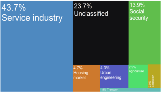
Głubczyce town budget income's sources as of 2015
-The town of Głubczyce's economy is based around the agricultural sector and food production. Formerly, during the Polish People's Republic, the industry of fibre production developed in the settlement ("Unia", "Piast" manufacturers). In modern days, the fibre manufacturing industry is near non-existent. Other industries located in Głubczyce including heating machinery production ("Galmet" and "Electromet")
-Głubczyce - Wikipedia https://en.wikipedia.org/wiki/G%C5%82ubczyce#Economy
-The local economy is created by modern and rapidly developing plants producing ecological central heating boilers, innovative heat pumps and other devices that use renewable energy sources.
-Dairy industry plants as well as trade and service companies are also doing well. Their dynamic development proves the effectiveness of investing in the Głubczyce region and is a perspective for local development. Opportunities for development are also existing investment areas designated for investment activities, with the necessary infrastructure or located in its vicinity, and the development of cooperation with foreign countries.
-Activities in the field of agri-food processing in the city and commune are carried out by:
-Top Farms "Głubczyce" Sp. z o . o. - slaughterhouse, butcher's shop, agri-food processing.
-Głubczyce SA Brewery - production of beer, cooling drinks and malt,
-Dairy Turek as part of the Savencia Group (Turek, Bongrain Polska and Toska) - milk processing,
-District Dairy Cooperative Głubczyce ,
-Głubczyce "Społem" PSS - bakery, confectionery production,
-In the village of Braciszów, there is also an open-cast mine of greywacke sandstone .
-Agricultural production traditions and very good natural conditions create an opportunity for the commune to develop the role of a food producer of good health quality.
-ECONOMIC BUSINESS CITY CITY (contact details of the largest companies):
-https://glubczyce.pl/153/12172/gospodarcza-wizytowka-miasta.html
Ⅳ.Industrial Characteristics
-The dominant branch of the economy in the commune. is agriculture. The development of agriculture is favored by very good soils (soil of classes I-III constitute 74% of the total arable land area) and the climate. The crop structure is dominated by cereal crops (wheat, rye and barley) - over 80% of crops and root crops (potatoes and beets) - nearly 10%.
-The local economy is created by modern and rapidly developing plants producing ecological central heating boilers, innovative heat pumps and other devices that use renewable energy sources. Dairy industry plants as well as trade and service companies are also doing well. Their dynamic development proves the effectiveness of investing in the Głubczyce region and is a perspective for local development. Opportunities for development are also existing investment areas designated for investment activities, with the necessary infrastructure or located in its vicinity, and the development of cooperation with foreign countries.
-The Głubczyce commune, situated mostly in the Głubczyce Plateau, is a typical agricultural commune.
-Głubczyce associates its future with the further development of agri-food processing and services related to agriculture. This is favored by the existing reserves in the field of agricultural production and the proximity of potentially large markets as well as the development of cooperation with foreign countries.
-The area of the commune is characterized by high land valuation, favorable agro-climatic and agro-ecological conditions, placing this area among the regions known for favorable natural conditions for agriculture: the Silesian Lowlands, the vicinity of Krakow, Rzeszów, Kalisz, Lublin and Żuławy. There are extremely fertile soils on loess formations, classified as "good wheat" soils of class IIIa and IVa (88% of agricultural land), with a certain deviation in the so-called mountain zone (about 8%) and rye soils (about 1%).
-Characteristics of the commune - Głubczyce commune https://glubczyce.pl/38/12093/charakterystyka-gminy.html
-1. "Local Program for the Revitalization of the City of Głubczyce until 2020"
-The Głubczyce commune started the development of the "Local Program for the Revitalization of the City of Głubczyce until 2020" co-financed by the European Union under the Operational Program Technical Assistance 2014-2020. Therefore, an agreement was concluded between the Opolskie Voivodeship and the Głubczyce Commune regarding the granting of a targeted subsidy for the development of the above program, selected in the grant competition Preparation or updating of revitalization programs.
-O projekcie - Gmina Głubczyce https://glubczyce.pl/1580/12421/o-projekcie.html
-2. Remote School + as part of the National Educational Network
-The Głubczyce commune received funding for the second time to support remote learning under the Operational Program Digital Poland for 2014-2020, this time under the grant project "Remote School + under the National Educational Network", Axis I Universal access to high-speed Internet, Measure 1.1 "Eliminating territorial differences in the possibility of access to broadband Internet with high speed", co-financed by the European Regional Development Fund under the Operational Program Digital Poland for 2014-2020.
-The aim of the project is to support the implementation of the core curriculum in the form of distance learning by providing access to equipment for the most needy students, including students from 3+ families. The aid will be directed to students from families in a difficult financial situation who have technical problems with participation in education in the conditions of the coronavirus epidemic. The new standards of conducting educational activities require sitting in front of computer monitors instead of at school benches in order to implement remote learning with the use of distance learning methods and techniques.
-Thanks to financial support in the amount of PLN 104,999.68, 101 portable computers with Windows 10 professional software and insurance were purchased, which were then sent directly to 5 centers run by the Głubczyce Commune. The final beneficiaries are students from the Głubczyce Commune, including students from large (3+) families.
-As in the first stage of supporting distance learning, the funding is 100% and there is no own contribution.
-Remote School + within the framework of the National Educational Network - Głubczyce Commune https://glubczyce.pl/3793/12304/zdalna-szkola-w-ramach-ogolnopolskiej-sieci-edukacyjnej.html
Ⅴ.Attrations and Cityscape
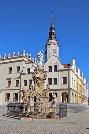
Reconstructed town hall and a plague column on main square
-WORTH SEEING
-Building of the Municipal Office in Głubczyce
-It was built in the years 1876-1879 in an eclectic style as the Landrat Office (district starosty). Currently, the seat of the commune authorities and the City Hall. On the first floor, in the north-eastern part, there is a council meeting room with a beautifully painted ceiling and a spider chandelier and sculptural decorations on the walls and doors from the second half of the 19th century.
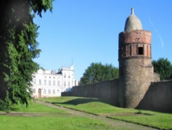
Defensive wall with towers
-It was documented for the first time in 1282. It was built of slate from the nearby village of Królowe. The best-preserved sections of the city wall, partially transformed in the 19th century, partially after 1945, are:
-next to the post office, where the tower is topped with a dome from the 16th century,
-in the Franciscan garden with a gate, in the jambs of which human faces and a skull are carved in stone,
-north of the parish church at the apartment blocks of ul. Ratuszowa with a tower covered with a shingled tented roof;
-at ul. Wałowa on the square of Primary School No. 2.
Railway station building
-It was built in the second half of the 19th century in the shape of a steam locomotive and has remained unchanged until today.
-Primary School No. 2 building, ul. Kochanowski.
-Fountain with animals in the city park.
-Founded by the owner of the brewery, Eduard Beyer, built in 1911-1912
-House on the corner of Pocztowa and Fabryczna, second half 19th century
-Tenement house at the corner of ul. Kochanowski and Niepodległości, second half of 19th century
-Tenement house at ul. Kochanowski, second half of XIX century, the seat of the County Office
-St. Anna at ul. Sobieski
-During the Thirty Years' War there was a funeral church here, where the poor inhabitants of the city were buried. In 1645 it was destroyed by the Swedes. The new church, Roman Catholic of the Holy Trinity, also called by the population the church of St. Anne was erected on the old foundations in 1778. After World War II it was taken over by the Polish-Catholic Church. In 1991, it was donated to the Roman Catholic Church, and in 1992 its external renovation began. today the baroque church of St. The Trinity has no equipment.
-The post office at ul. Postal
-Water tower - ul. Słowacki
-Parish Church
-The interior of the parish church. In the historic part of the temple, it is worth seeing: an early Gothic three-nave body with an entrance porch, stone plant decorations in the naves of the temple, an ancillary with cube capitals in the porch under the presbytery tower.
-Parish church gallery Parish church gallery Parish church gallery
-The complex of the Franciscan monastery
-The Franciscan church and monastery were founded in 1448 by the last prince - Przemyślida Opawa-Głubczycki, Jan Pious. It was originally built of wood. In 1476, wooden buildings burned down during a fire in the city. They were rebuilt using stone funded by Jan the Pious.
-The present complex was built in the years 1753-1770 according to the design of Jan Innocent Töpper from Prudnik. It includes the baroque church of St. st. Idzi and Bernardine and the characteristic four-wing monastery in the form of a square with a patio in the middle. Above the church portal there is a relief emblem of the Franciscan Order - the crossed arms of Christ and St. Francis of Assisi. The church has a single nave. The interior of the church is baroque and rococo. Adjacent to the monastery is a building erected in 1752, which once housed a gymnasium.
-Coat of arms on the building of the Primary School No. 2 - II half 19th century
-The figure of St. Florian from 1914 on Kozielska Street.
-The figure of St. Florian - the advocate during the fires comes from 1914. The pedestal on which stands St. Florian is decorated with city coats of arms. It commemorates the terrible fire of this part of the city in 1854.
-Municipal swimming pool
-The municipal swimming pool was built in the years 1978-1989 in place of an existing and demolished swimming pool from around 1936. The swimming pool includes 5 swimming pools: sports (Olympic) - deep 50m x 25m (2m deep), medium - 69m x 24m (depth 0.6m - 1.7m), two shallow (69m x 12m (depth 0.4m - 1m) and a paddling pool with dimensions of 54m x 14m (depth 40cm) The total water area is 6000 m2 and its volume is 7130 m2 .
-In the pool area there are also showers with cold water by the pool and with hot water in the building, changing rooms, toilets, washbasins with hot water, grass beaches with a total area of approx. 60 ares, a volleyball court, a children's playground by the paddling pool, a slide , fountain, parking for cars, bicycle stand, shopping facilities and a buffet. It is possible to leave valuable items free of charge in the ticket cashier's deposit)
-City panorama. View from the church tower
-Camping in Pietrowice
-Camping gallery Camping gallery Camping gallery Camping gallery Camping gallery Camping gallery Camping gallery Camping gallery
-The campsite (category I) is located 14 km from Głubczyce - 1 km from the border crossing between Poland and the Czech Republic. The standard of this center is proved by the fact that the Polish Federation of Camping and Caravanning was awarded the title of "Mister Camping 1995". In 1999 - the campsite was third, in 2000 - second and in 2005 - third. The competition for the best Polish camping has been organized every year for 40 years by the Polish Federation of Camping and Caravanning in cooperation with the Department of Tourism of the Ministry of Economy and the Polish Tourist Organization. All campsites affiliated with the PFCC participate in it. Camps - the winners of the competition are placed on the "Polish Map of Camps", in the "Recommended Camps" publishing house, published in Polish,
-In addition to 2 and 3-person rooms in brick tourist cottages (160 beds) and a hotel (24 beds), there is a campsite adapted to the stay of about 200 people and 18 positions for caravanning trailers. There is also a common room, a TV room, a buffet with a terrace, a fireplace for the grill, rings for bonfires, a kiosk with newspapers and basic industrial articles. There is also a bowling alley, playground, volleyball and basketball courts.
-The center's attraction is a swimming pool with a 11 m high and 25 m long slide and a jumping tower. It is possible to use the catering facilities in the center, as well as participate in dances and discos organized for guests. The property is open seasonally from 01 May to 31 October.
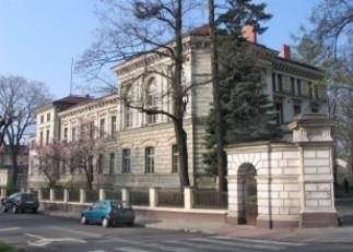
-The building of the General Secondary School from 1902.
-Built in 1900-1902 in the neo-Renaissance style for the needs of the Głubczyce gymnasium. Expanded southwards along Lwowska Street in 1931-1932. The windows of the auditorium are decorated with the coats of arms of Głubczyce and Silesia (black eagle with a white crescent on the chest in a yellow field) painted by students in 1902 on the windows. Adam Mickiewicz has been the patron of the school since 1956.
-New housing construction
-Bogdanowice, tombstones of the Bohdanowski family with Czech inscriptions from the 16th century.
-Embedded Renaissance tombstones of the Bohdanowski family from Ślimaków (16th century) with Moravian and German inscriptions. They are located in the cemetery wall, next to the church.
-Głubczycki Forest
-Głubczyce received the forest in 1265 from King Přemysl Otakar II. At that time, he had 20 łans and was called "Tropowitz", the Opawa river, from the Opava river, which formed the south-western border of the Głubczyce region. It was depleted during the colonization period. From the middle Ages it was called "the Beech Forest". In the 16th century it was considered a witches' asylum at night, and the main road crossing the forest was called the "Witch Birch Road".
-There are various types of natural forest communities: ash-alder riparian forests, submontane ash riparian forests and subcontinental oak-hornbeam forests. Large areas are also occupied by pine and mixed forests. Roe deer, foxes and hares live here from game animals. The Głubczycki Forest has significant biotherapeutic values and is of great importance for tourism and recreation for the inhabitants of Głubczyce. The City Forest is connected with the city by the three-row Lime Avenue, which is a natural monument.
Ⅵ.History and Culture
-Middle Ages
-The settlement named Glubcici was first mentioned in an 1107 deed. At the time, it was a small village, dominated by a large wooden castle. It stood on the right bank of the Psina River, which according to an 1137 peace treaty between the dukes Soběslav I of Bohemia and Bolesław III of Poland formed the border between the Moravian lands (then ruled by the Bohemian dukes) and the Polish province of Silesia. The exact date of the city foundation is unknown, but it is traceable back to 1224, when the town called Lubschicz held toll rights obtained from the Přemyslid king Ottokar I.
-Church of the Nativity of Virgin Mary
-However, in 1241 the town was devastated during the Mongol invasion. During the city's rebuilding, the left bank of the Psina was also settled, and in 1270 city rights were confirmed by King Ottokar II of Bohemia. During this time, a wall was built around the city, complete with watchtowers and a moat. A large parish church was also constructed in the town, which had been assigned by King Ottokar II to the Order of Saint John in 1259. After his defeat in the 1278 Battle on the Marchfeld, the town privileges were acknowledged by King Rudolf I of Germany. Ottokar's widow Kunigunda of Halych had a hospital erected, run by the Knights Hospitaller who established a commandry here. In 1298, the town received expanded rights from King Wenceslaus II. The privileges granted to the citizens were to serve as an example for other towns in the years that followed.
-From about 1269, Hlubčice was part of the Moravian Duchy of Troppau (Opava), ruled by a cadet branch of the Bohemian Přemyslid dynasty since Nicholas I, a natural son of King Ottokar II, had received the lands from the hands of his father. Upon the death of Nicholas' son Duke Nicholas II and the division of Troppau between his heirs, in 1377, the town became the residence of Nicholas III who ruled as a Duke of Głubczyce. The town remained the seat of the Troppau branch of the Přemyslids until the last Duke John II entered a Franciscan cloister in 1482. Upon his death three years later, his duchy was seized as a reverted fief by King Matthias Corvinus and transferred to the control of the Duchy of Krnov (Jägerndorf, Karniów) and the city finally lost its status as a residence.
-Modern Era
-While the Krnov principality was acquired by the Hohenzollern margrave George of Brandenburg-Ansbach in 1523, the Protestant Reformation reached the town. George had married Beatrice de Frangepan, the widow of Matthias Corvinus' son John; he and his son George Frederick tried to exert Hohenzollern influence in the Lands of the Bohemian Crown which from 1526 onwards were ruled by the Catholic House of Habsburg. In 1558, a Lutheran church and school were built in Głubczyce. In response to this, Franciscans and Jews were expelled from the city. During the Thirty Years' War, the city was completely destroyed, most devastatingly by Swedish forces in 1645.
-After the Silesian Wars, the city came under the rule of Prussia in 1743. Leobschütz was incorporated into the Province of Silesia by 1815 and became the administrative seat of a Landkreis (district). In 1781, the town's population stood at only, 2,637. In order to accommodate the city's expansion, parts of the city's wall were torn down. The population stood at 4,565 in 1825, and 9,546 in 1870. After World War I and the creation of the Republic of Poland, the Silesian plebiscite was held in Upper Silesia. The percentage of 99.5% of Leobschütz citizens voted for Germany. The Silesian Uprisings did not directly affect the city, which had almost exclusively German-speaking inhabitants.
-Former Leobschütz Synagoge, destroyed in 1938, with still existing parish church in the background
-After the Nazi seizure of power in 1933, the town hosted schools and training grounds for both the SS and the SA paramilitary forces, becoming the honorary centre of the Nazi Party in the Prussian Province of Upper Silesia. The town's synagogue was burned down in 1938, the same year as Kristallnacht. After the Vistula–Oder Offensive, on 18 March 1945, Red Army troops began a siege of the city, which was resisted by the 18th SS Panzergrenadier Division (Tank grenadiers) and the 371st Wehrmacht division. The siege ended on March 24, and the Soviet forces occupied the town. Approximately 40 percent of the town was destroyed in the siege or by Red Army troopers plundering in the first weeks of the occupation.
-After the Soviet occupation, the name of the town was changed to Głubczyce, its current name. The town was transferred, like most of Silesia, to the re-established Republic of Poland according to the 1945 Potsdam Agreement. The remaining German population was expelled and replaced by Polish refugees transferred from the Kresy in the former Polish eastern territories. Claims to the Głubczyce territory were raised by the Czechoslovak Republic, which even sent troops to the area in June 1945. The border dispute around Głubczyce was eventually settled in 1958 with the Czechoslovak-Polish border agreement. The town became the seat of a Polish county, or powiat, in 1946. Głubczyce lost that distinction in 1975, but regained it in 1999.
Ⅶ.Other Information
Głubczyce is a town in Opole Voivodeship in southern Poland, near the border with the Czech Republic. It is the administrative seat of Głubczyce County and Gmina Głubczyce.
Ⅷ.Contact Information
Government
• Mayor Adam Krupa
Głubczyce Commune 48-100 Głubczyce, ul. Niepodległości 14
Phone: +48 77 485 30 21 do 24
Fax: +48 77 485 24 16
Email: um@glubczyce.pl
NIP: 748-14-96-365
