Krotoszyn- Greater Poland 作者: 来源: 发布时间:2021-07-15
Ⅰ. Population and Area
Population (2006)
• Total 29,421
• Density 1,300/km2 (3,400/sq mi)
Area
• Total 22.55 km2 (8.71 sq mi)
Website http://www.krotoszyn.pl
Ⅱ.Natural Geography (environment and resources)
-POSITION
-Krotoszyn - 17 ° 26 'E - 51 ° 41' N
-(town)
-voiv. Wielkopolskie
-County Krotoszyn County
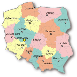
-Commune Krotoszyn (urban-rural commune) The commune has an agricultural and industrial character. Krotoszyn is located in the southern part of the Greater Poland Voivodeship, on the border of two important economic regions: Wielkopolska and Lower Silesia, approximately 108 km from Poznań, 80 km from Wrocław and 28 km from Ostrów Wielkopolski.
-Transport
-Two equal routes of rail and road communication intersect here.
-The first runs from north to south (Gniezno - Wrocław), the second from east to west (Łódź - Zielona Góra).
Ⅲ.Economy
-Krotoszyn is one of the most economically developed communes in Wielkopolska. Modern telecommunications equipment connects the city and the commune with the whole world. The developed technical infrastructure (roads, sewage system, gas supply, sewage treatment plant) creates perfect conditions for economic development.
-The developed economy of Krotoszyn allows for the import and export of goods, services, industrial cooperation and the creation of joint ventures. German and Dutch companies placed their capital here.
-The presence of banks is essential for the proper functioning of the market economy. Those that exist in Krotoszyn fulfill their role perfectly. The following associations operating in Krotoszyn also support business activity: the Entrepreneurs' Club of the Krotoszyn Region, the Krotoszyn Entrepreneurship Center, the Krotoszyn Trade and Service Association and the Guild of Various Crafts.
-The city authorities pursue a policy of undertaking economic initiatives. Among other things, they release entrepreneurs from local taxes. The City and Commune of Krotoszyn offers real estate for investments in the electronics, light and construction industries, agri-food processing, hotel industry, gastronomy, transport, trade and services.
-One of the fastest growing industrial zones operates in Krotoszyn - the Wałbrzych Special Economic Zone "INVEST-PARK". The Krotoszyn Subzone is located in the north-eastern part of the Krotoszyn Town, entirely within its borders. It is divided into two areas with a total area of 49.71 ha. The subzone is located on the border of the Dolnośląskie and Wielkopolskie provinces, which additionally increases its attractiveness. More information on the WSSE "INVEST-PARK" .
-The economic activity of the inhabitants of the city and commune is also expressed in the number of economic entities of natural persons. Currently, about 2,700 business entities are registered.
-Characteristics of the economy - Portal - Krotoszyn - the official website of the city https://www.krotoszyn.pl/strona-73-gospodarka.html
Ⅳ.Industrial Characteristics
-There are clay and mottled loam, wholesome raw materials for the production of building materials, shallowly underground here. The economic landscape of Krotoszyn is dominated by the machinery, construction, light and agri-food industries.
-Characteristics of the economy - Portal - Krotoszyn - the official website of the city https://www.krotoszyn.pl/strona-73-gospodarka.html
-The dominant trade is in grain and seeds, and the headquarters of the Polish branch of Mahle GmbH is located there.
-Krotoszyn - Wikipedia https://en.wikipedia.org/wiki/Krotoszyn#Economy
-Key Projects
-1. Krotoszyn City and Commune Promotion Strategy for 2012-2020 * Strategy for Solving Social Problems of the City and Commune Krotoszyn for the years 2014-2020
-Strategie, plany, programy Miasta i Gminy Krotoszyn - Portal - Krotoszyn - oficjalna strona miasta https://www.krotoszyn.pl/strona-76-strategie_plany_programy.html
-2. Education development plan for the City and Commune of Krotoszyn for 2018-2020
-Strategie, plany, programy Miasta i Gminy Krotoszyn - Portal - Krotoszyn - oficjalna strona miasta https://www.krotoszyn.pl/strona-76-strategie_plany_programy.html
Ⅴ.Attrations and Cityscape
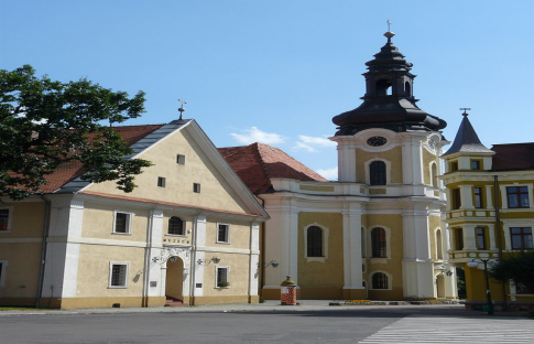
Regional Museum and Baroque Church of Saints Peter and Paul
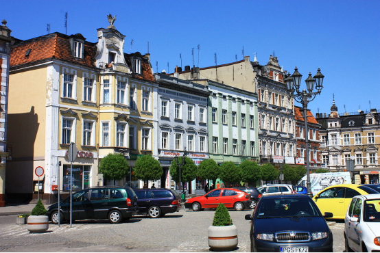
Historic townhouses at the Market Square
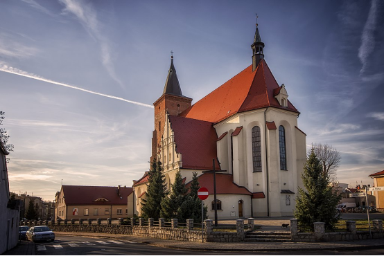
Gothic Saint John the Baptist church
-The barrow in Smoszewo
-Burial mounds are former burial places in the shape of a conical mound made of earth. The necropolis in Smoszewo is located within the oak forest, within the range of the Krotoszyn forest complex.
-More about the Smoszew mounds here.
-MONUMENTS
-The most beautiful churches and buildings worth seeing (short description and photos - here ):
-Town Hall
-Parish Church of St. John the Baptist
-Church of St. st. Fabian and Sebastian
-Church of St. Mary Magdalene
-The Baroque Potrynitarian Complex:
-1. Church of St. st. Piotra i Pawła
-2. Former monastery building
-3. Park next to the church
- Palace complex:
- 1. Gałecki Palace
- 2. Landscape park
-Post-Evangelical church complex:
- 1. St. Andrzeja Bobola
- 2. Former pastor's
- house 3. Former cantor's house
-Krotoszanka - the oldest preserved house in Krotoszyn from the second half of the 19th century Eighteenth century
Ⅵ.History and Culture
-The city was founded in 1415 by Wierzbięta from the Łódź Krotoski family under the privilege of King Władysław Jagiełło. The name of the village is possessive and means the property of Krotosz (the name derives from the Old Polish "short" - cheerful, gentle, kind).
-During the First Polish Republic, the city was owned by Polish noble and magnate families. In the 15th and 16th centuries, in the times of the Krotoski and subsequent owners, Krotoszyn was a small, poor and insignificant town. It was not until the end of the 16th century that it became a significant center of trade and crafts, especially brewing and weaving, in this part of Greater Poland.
-Presumably, from the end of the 15th century, Jews settled in Krotoszyn, who in the following centuries constituted nearly one third of all the town's inhabitants. At the beginning of the 18th century, the city fell into decline as a result of wars and the accompanying epidemics. The second invasion of the Swedes (1704-1717) and the plague epidemic (1708-1710) were particularly severe, when the completely ruined city had a population of several hundred.
-Krotoszyn recovered from its decline in the last years of pre-partition Poland, when in 1725 the owner of the Krotoszyn estate and the city became the Voivode of Kiev, Józef Pilawa Potocki. The abolition of obsolete serfdom in favor of rent and the introduction of allowances for settling craftsmen were of particular importance. The number of inhabitants increased to nearly 4,000. In Potocki's time, there were over 360 houses in Krotoszyn, including only 1 brick. The city had paved streets, an organized fire brigade, a city clock, waterworks and three city gates preserved, behind which stretched the suburbs: Koźmińskie, Kaliskie and Zdunowskie.
-After the second partition of Poland in 1793, the city passed into Prussian hands. At that time, the Krotoszyn poviat was created and in 1807 incorporated into the Duchy of Warsaw. After the Congress of Vienna in 1815, the city returned to Prussia, within the borders of the Grand Duchy of Poznań. The Germans established an administrative and judicial center in Krotoszyn, many offices and poviat institutions were established. At that time, the influx of German people, especially clerical families, intensified. The constantly expanding Evangelical community built its own church in 1790 - today the Church of St. Andrzej Bobola - and founded a school there.
-In 1819 the Prussian government handed over the Krotoszyn goods to Prince Charles von Thurn und Taxis in exchange for the postal monopoly in Rhineland and Westphalia. From then on, the city and the surrounding goods created the so-called Duchy of Krotoszyn.
-In the mid-nineteenth century, Krotoszyn was the fourth largest city in Wielkopolska. It had 7,687 inhabitants, including 2,699 Catholics, 2,660 Evangelicals and 2,319 Jews. Weaving collapsed during this period, while furriery and shoemaking developed. However, fundamental changes in the appearance of Krotoszyn took place only in the last quarter of the 19th century and at the beginning of the 20th century, when most of the industrial plants, schools and official buildings were built. The construction of the railway line was of great economic importance for the city.
-The city was expanding - on its outskirts, especially the western and northern outskirts, new streets and industrial plants were built: machine factory, breweries, sawmills, a brickyard, a slaughterhouse, and a distillery. Most of the market townhouses were rebuilt, and the town hall in 1898/99 gained the second floor and a new, pseudo-Renaissance façade. At the beginning of the 20th century, Krotoszyn was a green city. In the center there was a park of the prince of Thurn und Taxis, which was made available to residents.
-After World War I, Krotoszyn, liberated on January 1, 1919 by the Greater Poland insurgents, found itself within the borders of the reborn Polish state. The city maintained its agricultural and industrial character. This was due to the proximity of the German border and the agricultural character of the poviat. The peaceful and rhythmic development of the city was interrupted by the outbreak of World War II. On September 2, 1939, Krotoszyn was occupied by the Germans. The 56th Wlkp Infantry Regiment, stationed in Krotoszyn, took part in the Polish defensive war.
-After World War II, Krotoszyn remained the seat of the poviat and municipal and commune authorities. The city's population has doubled to 30,000 people. A number of apartment blocks were built, and new single-family housing estates were built on the outskirts of the city.
Ⅶ.Other Information
-Krotoszyn is a town in central Poland with 30,010 inhabitants as of 2005. It has been part of the Greater Poland Voivodeship since 1999; it was within Kalisz Voivodeship from 1975 to 1998.
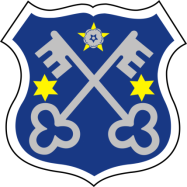
-The flag of Krotoszyn is a light blue fabric panel (CMYK color parameters - C = 55, M = 0, Y = 0, K = 0) in the shape of a rectangle, the ratio of width to length is 5: 8. In the upper left part of the rectangle there is city coat of arms. The parameters of the coat of arms are specified HERE . The ratio of the height of the coat of arms to the length of the piece of fabric is 1.5: 5.
-The ratio of the distance between the coat of arms from the upper and left edge of the rectangle to the length of the piece of fabric is 1: 10.
Ⅷ.Contact Information
Mayor Franciszek Marszałek
ul. Kołłataja 763-700 Krotoszyn
Tel.62 725 42 01
Fax.62 594 04 36
E-mail um@krotoszyn.pl
