Konin-Greater Poland 作者: 来源: 发布时间:2021-05-20
Ⅰ. Population and Area
Population (2017)
• Total 74,151 Decrease (48th)
Area
• Total 82 km2 (32 sq mi)
Website
http://www.konin.pl
Ⅱ.Natural Geography
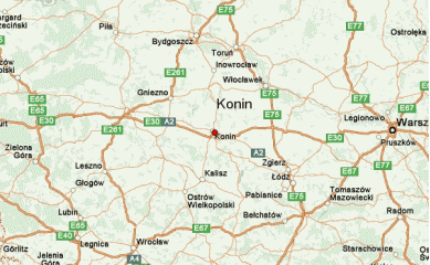
Konin is a city located in central Poland, in the eastern part of Greater Poland, on the Warta River. Currently, it has about 80,000 inhabitants. South of Konin runs the A2 motorway, connecting Warsaw with Poznań, which is part of the international route Berlin-Moscow. From the north to the south, the city is also crossed by the national road No. 25 (Bydgoszcz-Kalisz). The Berlin-Moscow railroad running through Konin and the Warta River flowing through the city, which connects them with the Baltic coast through a network of lakes and canals, create additional opportunities to use alternative means of transport.

Transport
Konin is a city located in the heart of the country on the Warta River in the eastern part of the Wielkopolska Province. Tere are 75 607 people living here. Konin is an important communication hub. The A2 motorway runs through the south borders of the city. There are two national roads: from North to South DK25 and from East to West DK92. The city is also crossed by railway line no. 3, part of the European E20 (Berlin - Moscow) railway line. On the outskirts of the city is the inland waterway on the Warta river, which is more than four hundred kilometers long. Nearby Konin there are also international airports: Poznań - Ławica Airport - 117 km, Wladyslaw Reymont Airport in Łódź - 121 km.
Ⅲ.Economy
The highest unemployment rate was in the Konin county – 7.5% (in the land counties it was 8.8%, in the city of Konin it was 5.9%)
Konin is one of the cities of Wielkopolska, which has great development potential. The actions of the city authorities are aimed at promoting Konin as an attractive investment destination as well as prepared for participation in projects as expected by investors. A new opportunity for further economic development of the city is the possibility of making investments in the form of public-private partnerships. Local entrepreneurs are prepared to cooperate with capital-contributing investors, who can bring new technologies or organizational solutions.
The city supports entrepreneurs who create new jobs. Relevant resolutions define the rules of assistance. Entrepreneurs can count on discounts in local taxes and fees as well as support from local government administration. Access to well-educated staff is an advantage that makes our region a very attractive investment.
The housing construction market is developing dynamically. Every year, the number of completed new residential premises increases. Konin is also a center of medical services for the region. The Provincial Complex Hospital is one of the largest hospital facilities in the region. Provides specialized health services in the field of prevention, health improvement and diagnostics. In addition, there are over 50 health clinics in the city.
Ⅳ.Industrial Characteristics
Konin is one of the largest centers of the fuel and energy industry in Poland (Zespół Elektrowni Pątnów Adamów Konin SA, owning the PAK KWB Konin SA and PAK KWB Adamów SA mines). It is thanks to him that it owes its dynamic development. The dominant role of the fuel and energy sector favored the development of other industries, such as:
-aluminum processing,
-agri-food industry,
-building materials industry.
The sector of small and medium-sized enterprises is developing with great success on the Konin economic market. Konin has great development opportunities and is prepared to participate in projects in accordance with the expectations of investors. A new opportunity for the further development of the city is the possibility of implementing investments in the form of public-private partnership. Local entrepreneurs are waiting for investors bringing capital, new technologies and organizational solutions. City authorities, with investors in mind, carry out activities aimed at expanding the infrastructure. There are also new spatial development plans. Konin's investment expenditures, per capita, are among the highest in Poland.
The Konin region is a large and absorbent market and an attractive place for the development of local and regional staff. The labor market in Konin is characterized by good theoretical and practical preparation of employees for work, good knowledge of foreign languages and the willingness to constantly improve professional qualifications.
Key projects
1. 100 apartments of the Konin MTBS are built
At the construction site of other buildings for the Municipal Social Housing Society in Konin, work continues. After the investment is completed, 100 apartments for rent will be built here.
The two-story buildings without architectural barriers will have silent elevators, energy-saving lighting, facade illumination and video monitoring.
The investment will complete the development of the quarter between Wodna, Kościelna and Szarych Szeregów Streets, where the PKS bus depot, a bus station and commercial and service barracks were once located. The total investment cost is PLN 28,600,000.
Powstaje 100 mieszkań konińskiego MTBSu - Witamy w Koninie http://www.konin.pl/index.php/jeden-news-new/powstaje-100-mieszkan-koninskiego-mtbsu.html
2. FDS 2020: more money for Konin
Konin will receive no 20, but 30 million funding from the Local Government Roads Fund (FDS) for the construction of the connection of I. Paderewskiego streets with Wyzwolenia. Considering the last 13 years, it is the largest road investment in our city implemented by the Municipal Roads Authority.
FDS 2020: więcej pieniędzy dla Konina - Witamy w Koninie http://www.konin.pl/index.php/jeden-news-new/fds-2020-wiecej-pieniedzy-dla-konina.html
Ⅴ.Attrations and Cityscape

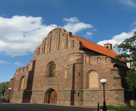
-Romanesque-Gothic St Bartholomew's Church

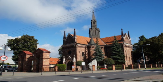
St. Andrew's Church

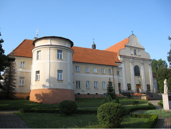
Monastery and St. Mary Magdalene's Church of Reformed Franciscans
Konin County (Powiat Koninski) contains examples of the following architectural forms: Romanesque, Gothic, Renaissance, Mannerist, Baroque, and Rococo; 18th century Classicism; 19th century Neo-Gothic, Neoromanesque, Neoclassicism, and Eclecticism; and 20th century Modernism, Nazi architecture, Socialist Realism, and Postmodernism. Also near Konin are the remains of the reinforced concrete bunkers employed by Poland's Armia Poznań during World War II.
Architecturally, the city of Konin is divided into two historical parts - Old Town (Stary Konin), situated on the south bank of the Warta; and New Konin (Nowy Konin), spreading northward from the river and developed primarily after 1945.
St. Bartholomew's Church
Romanesque
The Stone Signpost of Konin is the oldest European signpost beyond the boundaries of the Roman Empire. Made of local sandstone from the quarry near Brzeźno, it was commissioned in 1151 AD by either Duke Piotr Włost Włostowicz or Piotr Stary Wszeborowic. Containing Romanesque inscriptions, some scholars hypothesize that the stone itself was originally a Celtic sculpture.
St Bartholomew's parish church was rebuilt in the second half of the 14th century, but its Romanesque features are still visible in the external walls, particularly the north wall. The features include dressed stones made of sandstone and a massive stone cross built into the wall.
St. Andrew's Church
Gothic
St Bartholomew's Parish Church is Konin's most notable example of Gothic architecture and art. It contains a gothic net and vault inside the church and stained glass in the chancel.
St Andrew's Church, in Konin's Gosławice district, is a rural Gothic church with an unusual Greek cross. The building also contains a rare fan vault. Sandstone bosses and other details are richly carved. The external walls are embellished with a number of coats of arms.
The 15th-century mediaeval castle in Gosławice, currently a regional museum, was built at the direction of Poznań's Bishop Andrzej Łaskarz in 1418–1426. It was designed to be defended with firearms. Gosławice contains a rare collection of historical buildings, with its ancient village, Gothic church, mediaeval castle, and old Polish manor.
Renaissance
On the grounds of St. Bartholomew's Church is the Late Renaissance chapel of Jan Zemełko (Zemelius), a local physician, Renaissance man, and well-known member of the middle class in Konin and Kalisz.
The former home of Jan Zemełko, on the Plac Wolności, has been refurbished many times since Zemełko's era, but the main hall still contains the original barrel vault. At the ground floor level, the walls are exceedingly thick (1 to 2 m).
Mannerism
The Manneristic tombstone of Stanisław Przyjemski is located at the north wall of the main nave of St. Bartholomew's Parish Church.
Manneristic wooden stalls, with inlaid work, are located in the Chapel of Jan Zemełko (Zemelius).
Monastery and St. Mary Magdalene's Church of Reformed Franciscans
Baroque
St. Bartholomew's Parish Church contains many Baroque altars, epitaphs, and stalls, and a Late Baroque wall crucifix hangs in the porch. The Late Baroque church organ dates from the 18th century.
The Baroque monastery and church building at St. Mary Magdalene's Church of Reformed Franciscans were built in 1631.
Rococo
At St. Bartholomew's Parish Church, Rococo elements are found in the wall crucifix above the entrance to the porch at the north wall of the main nave and in the main altar at the Chapel of Jan Zemełko.
Ⅵ.History and Culture
Konin is located in the central part of Poland. In the past and today, in the immediate vicinity of the city, there is an important communication junction - connecting the north of the country with the south and the eastern part with the west. The fact that important trade routes have always run through Konin is evidenced by the 12th-century road pole erected in the center of the former Konin, which used to mark half the way between Kalisz and Kruszwica - lying on the former Amber Route. The most important settlement was the Old Town with a Romanesque parish church. It gave rise to Konin founded on the Magdeburg Law, following the example of Kalisz, around 1283. Since then, Konin, located on an island, in the Warta riverbed, was a stronghold guarding the ford on the river.
Konin's fate was a reflection of the country's history - starting in 1331, when the Teutonic Knights completely destroyed it. Rebuilt by King Casimir the Great (1333-1370) and surrounded by a wall - along with two gates: Kaliska and Toruńska - guarded the crossings on the route leading to other cities. Konin became the seat of the judicial district, and the Konin castle became the seat of the staroste and the administrative and economic center of the immediate vicinity. In the following centuries, craftsmanship developed rapidly in the city, which testified to its economic condition. Even then, Konin was an important center of culture and new religious trends, as well as medicine.
At the turn of the 16th and 17th centuries, two outstanding doctors who graduated in Padua were active here: the founder of the oldest departments of anatomy and medical botany of the University of Krakow in Poland - Jan Zemełka and Kacper Blewski. The successful development of Konin was stopped in the 17th century. In 1628, there was an epidemic lasting three years, which decimated the population. The disasters of this period aggravated the "Swedish deluge", fires and subsequent epidemics. After the fall of the Duchy of Warsaw, Konin found itself within the borders of the Congress Kingdom. The January Uprising (1863) took place here in a particularly severe, bloody form, marked by numerous battles and repressions. After the Congress Kingdom, the city ceased to be the center of the region for many years.
Regaining independence in 1918 did not bring the expected improvement in the economic situation. There were no water supply and sewage systems, and the inhabitants were acutely affected by the economic crises of the late twenties and thirties.
The revival was brought only by the opening of the railway line connecting Poznań with Warsaw and the construction of the Ślesiński Canal, connecting the Warta River with Lake Gopło. During World War II, Konin found itself in the area of lands incorporated into the Third Reich, as part of the so-called Warta country. At the same time, it became the seat of the Nazi district authorities. In the surrounding forests, the Nazis carried out mass murders of the Polish people of the Orthodox faith. After the Second World War, the 1950s and 1960s brought a rapid industrialization process, which changed the face of the agricultural region until now. In 1950 Konin had 12,145 inhabitants, 10 years later - 17,638, in 1970 - 40,744. However, in 1998 the city was inhabited by over 83.5 thousand. people. Such a rapid population growth also resulted in the rapid spatial development of Konin. The city absorbed more and more suburban villages, more and more distant from the historic center. The area of the city is now 82 km2. The urban concept adopted in the 1950s led to the creation of two separate parts of the city, separated by an undeveloped space around the Warta River.
Konin remains an important administrative center, having been the capital of the voivodeship since 1975, and since January 1, 1999, when the local government reform came into force, the city, losing its voivodeship status, became the seat of the town district and the capital of the land poviat. It is still the center of dynamically developing political and social life for the entire area of Eastern Greater Poland and the Greater Poland Voivodeship.
Ⅶ.Other Information
Konin is a city in central Poland, on the Warta River. It is the capital of Konin County and is located within the Greater Poland Voivodeship. Prior to 1999, it was the capital of the Konin Voivodeship (1975–1998). In 2018, the population of the city was 74,151 making it the third-largest city in Greater Poland after Poznań and Kalisz.
Ⅷ.Contact Information
-62-500 Konin Plac Wolności 1
-tel. 63 240 11 11
-fax 63 242 99 20
-e-mail: sekretariat@konin.um.gov.pl
-Mayor Piotr Korytkowski
