Hörgársveit 作者: 来源: 发布时间:2021-06-15
一、所属省或是州,具体位置,人口,面积
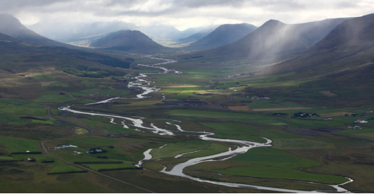
Hörgársveit is a municipality by Eyjafjörður located in north-central Iceland, in Northeastern Region. It has a population of 559 and a total area of 893 square kilometers. It was established on 12 June 2010 with the merger of Hörgárbyggð and Arnarneshreppur. Hörgárbyggð was previously established on 1 January 2001 with the merger of Skriðuhrepp, Öxnadalshreppur and Glæsibæjarhreppur. The municipality covers Galmaströnd, Hörgárdalur, Öxnadalur and Kræklingahlíð.
二、自然地理
1.地理条件
Located on the Eyjafjörður, to the north of Akureyri, Hörgársveit is made up of several villages, principally Þelamörk, Lónsbakki (115 inhabitants) and Hjalteyri (37 inhabitants), the seat of the former municipality of Arnarnes.
Eyjafjörður is the longest fjord in Iceland. The fjord is long and narrow and measures 60 km from its head to its mouth. Its greatest width is 15 km between Ólafsfjörður and Gjögurtá at the fjord's mouth, but for the greater part of its length it is mostly 5–10 km wide.
The fjord is surrounded by hills and mountains on both sides; the mountains are taller on the west side, in the mountain range of the Tröllaskagi peninsula. In the outer part of the fjord there are no lowlands along the coast as the steep hills roll directly into the sea. Further south in the fjord there are strips of lowland along both coasts; these are wider on the west side.
Several valleys lead from Eyjafjörður: most of them to the west, where the two most significant are Hörgárdalur and Svarfaðardalur. Dalsmynni is the only valley on the east side. However the largest valley in the area is Eyjafjarðardalur, which runs directly south from the fjord itself. It is about 50 km long, and is home to one of Iceland's largest agricultural regions.
Several rivers flow into Eyjafjörður: the most significant are Eyjafjarðará and Hörgá (whose valleys are named above), and Fnjóská (which flows into the fjord via Dalsmynni).
The island of Hrísey in the middle of Eyjafjörður is the second largest island off the coast of Iceland and often referred to as "The Pearl of Eyjafjörður".
Eyjafjörður contains a number of hydrothermal vents in shallow (20 to 65 metres) water, with cones rising up to 20 metres below the water surface.
2.交通情况
Hörgársveit is located directly on the National Ring Road 1. The largest town nearest to the municipality is Akureyri which is about 55 kilometers Northeast via the National Ring Road 1. Akureyri has a domestic airport which can be reached from Reykjavik.
Hörgársveit is about a 4-hour drive around the 1 Ring road from Reykjavik at a total of 333 kilometers distance.
三、经济发展和规模
INCOME STATEMENT 2019
Operating income (in Icelandic Kroner)
- Tax: 285,965,000
- Contributions of the equalization fund: 176,822,000
- Real estate taxes: 60,222,000
- Sales revenue: 17.627,000
- Service income: 130,478,000
- License fees: 400,000
- Other income: 25,655,000
Total operating income: 697,169,000
Operating expenses (in Icelandic Kroner)
- Salaries and related expenses: 310,980,000
- Purchase of goods: 34,515,000
- Purchase of services: 124,642,000
- Energy costs: 10,430,000
- Maintenance costs: 52,075,000
- Other operating expenses: 38,274,000
- Grants and other: 53,258,000
- Taxes and fees: 5,994,000
- Depreciation: 18,525,000
Total operating expenses: -648,693,000
https://www.horgarsveit.is/is/stjornsysla/fjarhagsaaetlanir
四、产业特点/重点项目
Hörgársveit is for the most part a rural area where traditional farming is practiced. Small towns are Lónsbakki, just north of Lónsinn, and Hjalteyri, north of the municipality. On Lónsbakki are the streets Skógarhlíð, Birkihlíð and Reynihlíð.
The municipality's primary school is Þelamerkurskóli in Laugaland. By the school is a sports hall and swimming pool, Íþróttamiðstöðin á Þelamörk. At Lónsbakki is the municipality's kindergarten, called Álfasteinn.
There are two community centers in the municipality, Hlíðarbær in Kræklingahlíð which is owned by Regla Musterisriddari and Melar in Hörgárdalur which is owned by Leikfélag Hörgdælar. Leikfélag Hörgdæla has shown plays at Melur, usually every other winter with great attendance and a good reputation. There are four churches in the municipality, which are served by the parish priest at Möðruvellir. The churches are at Möðruvellir, Bægisá, Bakki and Glæsibær.
https://www.horgarsveit.is/
五、风景名胜,景点( attractions)
1. Gásir market town
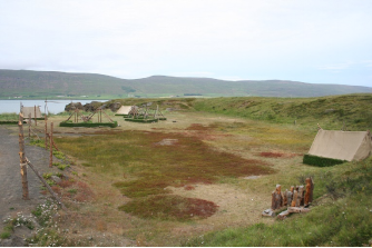
Gásir or Gásakaupstaður was an ancient trading place in Gáseyri at the mouth of Hörgár in Eyjafjörður. Gásir was the main trading place in the North in the Middle Ages. The place is about 11 km north of Akureyri.
It is not known when the trade began in Gásir, but the oldest sources about it are from the second half of the 12th century and the youngest from 1394. It is clear from sources that Gásir was the main stock exchange in the North in the 13th and 14th centuries. are mainly from that time. It is possible that a merchant ship came to Gásar after the 15th century, but it is not clear why the place closed down and trade moved to Akureyri. One theory is that the pronunciation from Hörgá, especially due to landslides in Hörgárdalur in 1390, made the harbor unusable for larger merchant ships, but there is also a possible explanation that changed trade practices in the 15th century, when English ships began to sail to Iceland, sailing there ceased. Today, Gásir is protected according to Icelandic national heritage law and is managed by the State Archaeological Conservation.
Extensive archeological excavations took place at Gásar in the years 2001-2006. There are ruins of a town from ancient times. The private institution Gásakaupstaður intends to build tourism with an emphasis on the Middle Ages in the coming years.
2. Hraundrangi Peak
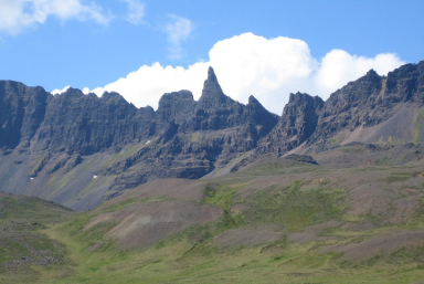
Hraundrangi (Lava Column or Rockfall Spire) is a conical peak in the Drangafjall ridge dividing Öxnadalur from Hörgárdalur in north Iceland. It rises to 1,075 metres (3,527 ft) above sea level, 80 metres (260 ft) above the ridge. It was probably originally named simply "Drangi" and acquired the prefix from the farm of Hraun, which lies below it on the Öxnadalur side. The ridge is often erroneously referred to as Hraundrangar, the plural of Hraundrangi.
The mountain rises to an unusually sharp point, less than half a square metre at the peak. It is a lava spire that remains with the rest of the ridge after much of the original mountain, Háafjall, fell in a large rockslide many centuries ago.
The first successful ascent of Hraundrangi was on 5 August 1956, by Finnur Eyjólfsson and Sigurður Waage of the Icelandic Air Ground Rescue Team and United States Air Force Lieutenant Nicholas Clinch. A legend that a treasure chest would be found on the peak proved untrue.
The mountain features in "Ferðalok" ("Journey's End"), a poem written at the end of his life by Jónas Hallgrímsson, who was born at Hraun. The last stanza of the poem alludes to a legend that the saga hero Grettir the Strong climbed it and left his knife and belt on the peak as proof; Hraundrangi was supposedly also called Grettisnúpa" ("Grettir's Crag") by the people of Öxnadalur.
The 10,000 Icelandic krónur banknote issued in October 2013 honours Jónas Hallgrímsson and has on the obverse a background image of Hraundrangi and the rest of the ridge formed out of neologisms coined by the poet.
3. Möðruvellir Monastery (Hörgárdalur)
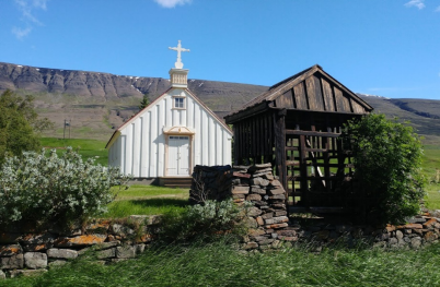
Möðruvellir in Hörgárdalur is a town and church in Hörgárdalur in Arnarneshreppur by Eyjafjörður. Möðruvellir has been inhabited since the settlement age and is widely mentioned in ancient stories, but mostly Sturlunga. Möðruvellir is very much connected to the history of Iceland and Denmark in various ways. For a long time there was one of the main estates of Iceland and Möðruvallaskóli was run there. Möðruvallaklaustur was founded there in 1296. Many officials on behalf of the Danish kings have lived there and among others, Hannes Hafstein was born, the firstMinister of Iceland, there in 1861.
The church that now stands on Möðruvellir was built in the years 1865-1867 after the church fire in 1865 and was then the largest wooden church in the country. The church has many beautiful memories that have been given to it.
There are two cemeteries by the church: the old and the new. The older one is bounded by a neat rock garden to the south and north, and a timber fence to the east and west. At the front there is a covered soul gate that makes a great impression on the place and in it is cut and painted verse 7 from the 2nd psalm.
六、历史文化
1.历史
The municipality Hörgársveit was created on June 12, 2010 through a merger of the municipalities Hörgárbyggð and Arnarnes (Arnarneshreppur).
The former municipality of Hörgárbyggð was created on January 1, 2001 through the merger of the rural communities Skriða ( Skriðuhreppur ), Öxnadalur ( Öxnadalshreppur ) and Glæsibær ( Glæsibæjarhreppur ). The main town of the former municipality of Arnarnes was Hjalteyri.
In a referendum on October 8, 2005, both former municipalities rejected an incorporation into Akureyri.
History of the Region:
In the Middle Ages there was a well-known Augustinian monastery in Möðruvellir located in the municipality, the Möðruvallaklaustur, in which manuscripts were also written. It was built in 1296, but burned down in 1316.
After the Reformation, the valuable property came into the hands of the Danish kings in 1550 and many of their highest administrative officials for the north of Iceland settled there. In 1628 the first known owner of a medieval manuscript in Iceland signed it up; today it is called Möðruvallabók. The current church was built between 1865 and 1867.
One of the first high schools in Iceland was founded in Möðruvellir in 1880. It was on site until 1902, but it burned down and was then moved to Akureyri.
Hjalteyri is one of the few settlements still populated in the municipality. It is located on the west bank of Eyjafjörður and is 23 km from Akureyri. Around 1880, Norwegians, Swedes, Germans and Scots started salting herring here. A fishing village was created with many herring and cod fishing boats. During the First World War the foreigners left Iceland and the Dane Thor Jensen took over the fish processing. He set up a herring factory in Hjalteyri, which was the largest in Europe at the time. One of the customers was the Nordsee Deutsche Hochseefischerei. In May 1954, a fire broke out in the factory and caused great damage. The factory closed in 1966 and its buildings have been used for exhibitions since 2008.
2. 文化体育
Hörgársveit is for the most part a rural area where traditional farming is practiced. Small towns are Lónsbakki, just north of Lónsinn, and Hjalteyri, north of the municipality. On Lónsbakki are the streets Skógarhlíð, Birkihlíð and Reynihlíð.
The municipality's primary school is Þelamerkurskóli in Laugaland. By the school is a sports hall and swimming pool, Íþróttamiðstöðin á Þelamörk. At Lónsbakki is the municipality's kindergarten, called Álfasteinn.
There are two community centers in the municipality, Hlíðarbær in Kræklingahlíð which is owned by Regla Musterisriddari and Melar in Hörgárdalur which is owned by Leikfélag Hörgdælar. Leikfélag Hörgdæla has shown plays at Melur, usually every other winter with great attendance and a good reputation. There are four churches in the municipality, which are served by the parish priest at Möðruvellir. The churches are at Möðruvellir, Bægisá, Bakki and Glæsibær.
Möðruvellir is an ancient manor. A monastery was established there by the Augustine Order of 1296, which lasted until the Reformation. The first computer science school in Iceland was established there in 1880.
Jónas Hallgrímsson's birthplace is at Hraun in Öxnadalur. There is now a scholar's apartment and memorial rooms for Jónas. A public park has been established on most of the land there. Jónas Hallgrímsson (born November 16, 1807 in Hraun im Öxnadalur, today Hörgársveit municipality, † May 26, 1845 in Copenhagen) was an Icelandic poet and scientist who is revered in Iceland as a national hero.
https://www.horgarsveit.is/is/frodleikur/sveitarlysing
七、其他信息
Municipalities Without Nuclear Weapons
The local government of Hörgárbyggð declared the municipality a nuclear-weapon-free zone at a meeting on September 18, 2002. On that occasion, the district committee demanded the elimination of all nuclear weapons in the world. The municipality is among many other municipalities that have issued a similar statement. The goal is for the whole country to be protected in this way from weapons of mass destruction.
https://www.horgarsveit.is/is/stjornsysla/svaedi-an-kjarnorkuvopna
八、联系方式
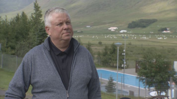
Mayor: Snorri Finnlaugsson
Telephone: 460 1750
Email: horgarsveit@horgarsveit.is
https://www.horgarsveit.is/is/stjornsysla/skrifstofa
