Roscommon, in the province of Connaught, north-central Ireland 作者: 来源: 发布时间:2021-04-13
I.Population and Area
Population in 2011:64,065
Population in 2016:64,544
Population Density in 2011: 23 people per square km2
Total Area: 983.79 sq miles

II.Natural Geography (Environment, resource and transportation)
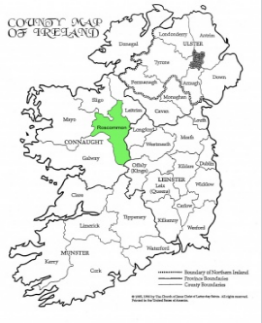
It is named after the town of Roscommon. Roscommon County Council is the local authority for the county. It is bounded by Counties Sligo (north), Leitrim (northeast), Longford and Westmeath (east), Offaly (southeast), Galway (southwest), and Mayo (west). The town of Roscommon, in the central part of the county, is the county town (seat), and there is a county manager.
Cemeteries of County Roscommon Ireland are located across the county. Listed here are cemetery records that have been published online.
Roscommon is the 9th largest of the 32 counties of Ireland by area and the fifth least-populous county in Ireland. It has an area of 984 square miles. It has the second least population density after Leitrim. It is the third largest of Connacht’s five counties by size and fourth largest in terms of population.
Roscommon comes from the Irish Ros meaning a wooded, gentle height and Comán, the name of the county's famous saint and the first bishop of the see. Rathcroghan was home to the Kings of Connacht and then to the High Kings of Ireland.

Most of the county lies between the River Shannon and its major tributary, the River Suck. Athlone on the Shannon is the main point of entry to the county; north of it lies Lough (Lake) Ree and, farther upstream, Loughs Bofin and Boderg. Along most of its course are extensive water meadows known as callows. Between the Shannon and the Suck the landscape is a mixture of limestone surfaces 200–400 feet (60–120 metres) high and depressions varying from peat bogs to water meadows. There are also some eskers (long ridges of postglacial gravel) that are quarried extensively. Within this area sheep and cattle are raised, particularly on the limestone pastures, and oats, hay, and potatoes are the main crops. About three-fourths of the area is farmland, the rest peat bog. To the east of Boyle the rich limestone grasslands, known as the Plains of Boyle, are famed as cattle pastures. Farms are small, with a concentration on cattle. To the northeast of Roscommon town, the Slieve Bawn ridge rises to 846 feet (258 metres).
The area is greatly dependent on agriculture, though there is some light industry. The towns have a strong retail trade and monthly fairs, however, and coal mining in Ireland was centred at Arigna until the mine’s closure. The Famine Museum (1994), located at Strokestown Park, commemorates the Irish Potato Famine of 1845–49.
Reference website: http://www.irelandcemeteryrecords.com/county-roscommon-ireland-cemetery-records.htm
Transportation:
The closest major airport to Roscommon, Ireland is Ireland West Airport Knock (NOC / EIKN). This airport is in Charlestown, Ireland and is 69 km from the center of Roscommon, Ireland. If you're looking for international flights to NOC, check the airlines that fly to NOC. Search for direct flights from your hometown and find hotels near Roscommon, Ireland, or scroll down for more international airports.
III. ECONOMY

IV.Industrial Characteristics:
1)West-Roscommon Business&Technology Park
Roscommon Business & Technology Park is an c.12 hectare (c.29 acre) park located on the N60 national primary route. The park has been designed and landscaped to a high standard including a services infrastructure to suit both manufacturing and international services sectors.
2)Cubis Industries Ltd
Find Cubis Industries Ltd on constructionireland.ie. Get contact details, gallery, services and general information. Find Cubis Industries Ltd, Roscommon in the Drainage Pipes & Fittings sector
V.Attractions
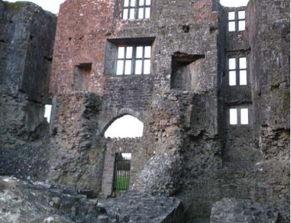
Roscommon Castle is a dramatic and imposing 13th Century Norman Castle. It was built in 1269 by Robert de Ufford, Justiciciar of Ireland, on lands he had seized from the AugustinianPriory. It was besieged by the Connacht King Aodh O’Connor in 1272 and eight years later it was again in the hands of the English garrison and fully
restored.

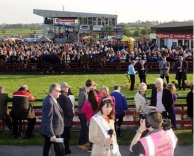
Lenebane, Roscommon F42 V052 Ireland. Website +353 90 662 6231. Email. Best nearby. 18 Restaurants within 5 miles.13 Other Attractions within 5 miles. Regan's Gastro Pub and Re staurant (213)1.7 mi Irish.

Reference website:
https://www.tripadvisor.ie/Attraction_Review-g315887-d12490319-Reviews-Roscommon_Racecourse-Roscommon_County_Roscommon_Western_Ireland.html
VI.History
Rathcroghan, near Tulsk, a complex of archaeological sites, the home of Queen Medb, was the seat of Kings of Connacht and then to the High Kings of Ireland. This was the starting point of the Cattle Raid of Cooley, an epic tale in Irish mythology. County Roscommon as an administrative division has its origins in the medieval period. With the conquest and division of the Kingdom of Connacht, those districts in the east retained by King John covered County Roscommon, and parts of East Galway. These districts were leased to the native kings of Connacht and eventually became the county. In 1585 during the Tudor re-establishment of counties under the Composition of Connacht, Roscommon was established with the South-west boundary now along the River Suck
Reference website: https://www.familysearch.org/wiki/en/County_Roscommon,_Ireland_Genealogy#cite_note-1
VII.Other information:
Ballintubber is a small village nestled in the heart of rural County Rosommon in the west of Ireland.
Ballintubber became the principal seat of the O’Connors after the Anglo-Norman invasion at the end of the 12th century. It is first mentioned in the Annals of the Four Masters in 1311 and in 1315 when the leader of the rebellious sect of the O’Connors seized the castle. Ballintubber castle is the only surviving early medieval castle of an Irish ruler.
Visitors to Ballintubber will be welcomed by outstanding natural scenery, rolling hills and green meadows surround the village on every side, the river suck flows close by and boasts some of the most spectacular walking routes in the entire county. The village itself has a beautiful 18th century Catholic Church at the heart of the community, an 18th century cemetery, old school house museum and some exceptional local bars and amenities to cater for all tastes.
Every year, Ballintubber hosts a number of events including a St Patrick's day parade which has rapidly become one of the biggest in Roscommon, regular Suck Valley walks and a community led "walk & talk" event to help counter act mental illness. In July, the village really comes alive with the annual heritage festival taking place for most of the month. During the festival, the village welcomes guests from the United States who conduct archaeological excavations on the castle and its surrounding grounds. The festival really gives the guests an insight into Ballintubber, its history and the culture of the village in bygone times.
As a testament to the commitment of the local residents to look after the village, Ballintuber is regularly shortlisted for numerous local, regional and national tidy towns awards.
We welcome all visitors to our small and beautiful village and we know you will enjoy the experience. Ballintubber is a thriving place with a great future and we hope that you too will be part of it.
Reference website: https://www.ballintubbervillage.com/our-village
VIII.Contact information
-Mayor
Paschal Fitzmaurice
Ballindrimley, Castlerea, Co. Roscommon
Tel: 087 2299980
Email: cllrpfitzmaurice@roscommoncoco.ie
Reference website: http://www.roscommoncoco.ie/en/About_Us/Local_Representatives/
