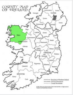
Mayo, in the province of Connaught, western Ireland 作者: 来源: 发布时间:2021-04-13
I.Population and Area
Population in 2011:122,897
Population in 2016:130,507
Population Density: 149 people per square km
Total Area: 2,157 sq miles
II.Natural Geography (Environment, resource and transportation)
Mayo is bounded by the Atlantic Ocean (north and west) and by Counties Sligo (northeast), Roscommon (east), and Galway (southeast and south). Castlebar, in central Mayo, is the county town (seat). Other important towns include Ballina (the seat of the Roman Catholic bishop of Killala) and Westport.
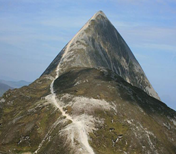
Mayo’s extensive coastline is wild and broken, with many inlets from Killala Bay in the north to Killary Harbour in the southwest. Westport and Ballina are port towns, and there are numerous islands and inland lakes. Stretching east and north from Lough (Lake) Carrowmore is the largest expanse of bog in Ireland, 200 square miles (520 square km) in area. The principal rivers in Mayo are the Moy and the Errif. The low peaks of Nephin (2,646 feet [807 metres]) and Croagh Patrick (2,510 feet [765 metres]) dominate the landscape, and Mweelrea (2,688 feet [819 metres]), to the north of Killary Harbour, is the highest mountain in Connaught.
In the rugged mountains of the north and west, the farms are small, and much of the population supplements its earnings by migration to Great Britain. About one-fourth of the population is employed in agriculture. Cattle for the British market and sheep and pigs are raised extensively. Tourism is an important source of income, and the area is particularly attractive to fishermen and bird hunters. There is some light industry in the county, including flour milling and textile manufacturing.
Reference website: https://www.britannica.com/place/Mayo-county-Ireland
Transportation:
As its name suggests, this airport is located in Cork city, and it is the second largest airport in Ireland after the Dublin airport. In 2017, Cork airport is said to have served approximately 2.3 million passengers making it the second busiest airport in the state of Ireland regarding passenger numbers. Due to the location of this airport, it is mostly affected by fog and low cloud ceiling. Since its opening in 1961, Cork airport has been operated by the Department of Transport and Power, which is currently the Department of Transport.
III.ECONOMY
IV.Industrial Characteristics:
1)Tiger oil company limited
Tiger Oil is a wholly owned Irish company specialising in oil services for domestic home heating and commercial vehicles. We are a family business and have been providing tailored solutions to meet the needs of individual clientele in the Greater Drogheda area for over 30 years.
2)Global Tyres
Welcome to Global Tyre Co., a major wholesale and retail tyre distributor. As well as providing and fitting new car tyres for individuals and fleet customers, we also specialise in van and truck tyres as well as tyres for agricultural and 4x4 vehicles. We stock a huge range of tyres from all of the top brands and also offer free tyre checks and ...
V.Attractions
Ballintubber Abbey
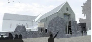
Founded by the King of Connaught, Cathal Crovdearg in 1216, the impressive Ballintubber (or Ballintober) Abbey in North Mayo is still in use, but has many original features from different centuries including animals and foliage carvings. The abbey was founded beside a holy well dedicated to Saint Patrick who came here after his fast on Croagh Patrick. The full Reek Sunday pilgrimage to the holy mountain traditionally starts from the Abbey.
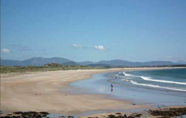
Beaches in County Mayo
Old Head and Silver Strand deserted beaches near Louisburgh, Bertra Strand near Murrisk, scenic Killadoon beach near Cregganbaun, sandy beaches on Clare Island and Inisturk Islands, Long Mallaranny Strand near Mulrany town, clean sandy beaches on Achill Island, sandy beaches, sheltered sandy Lackan Bay beach at Downpatrick Head. Downpatrick Head also has a cliff puffing hole or glory hole.
VI.History
Christianity came to Ireland around the start of the 5th century AD. It brought many changes including the introduction of writing and recording events. The tribal 'tuatha' and the new religious settlements existed side by side. Sometimes it suited the chieftains to become part of the early Churches, other times they remained as separate entities. the middle of the 6th century hundreds of small monastic settlements were established around the county.
In 795 the first of the Viking raids took place. The Vikings came from Scandinavia to raid the monasteries as they were places of wealth with precious metal working taking place in them. Some of the larger ecclesiastical settlements erected round towers to prevent their precious items being plundered and also to show their status and strength against these pagan raiders from the north.
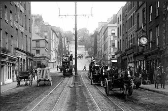
From 1169 when one of the warring kings in the east of Ireland appealed to the King of England for help in his fight with a neighbouring king, the response of which was the arrival of the Anglo-Norman colonization of Ireland. County Mayo came under Norman control in 1235. Norman control meant the eclipse of many Gaelic lords and chieftains, Norman names are still common in County Mayo. Following the collapse of the lordship in the 1330s, all these families became estranged from the Anglo-Irish administration based in Dublin and assimilated with the Gaelic-Irish, adopting their language, religion, dress, laws, customs and culture and marrying into Irish families.
The Anglo Normans encouraged and established many religious orders from continental Europe to settle in Ireland. large churches, many under the patronage of prominent Gaelic families. Spaniards came ashore in Mayo, only to be robbed and imprisoned, and in many cases slaughtered. Almost all the religious foundations set up by the Anglo Normans were suppressed in the wake of the Reformation in the 16th century. Protestant settlers from Scotland, England, and elsewhere in Ireland, settled in the County in the early 17th century. Many would be killed or forced to flee because of the 1641 Rebellion, during which a number of massacres were committed by the Catholic Gaelic Irish, most notably at Shrule in 1642. A third of the overall population was reported to have perished due to warfare, famine and plague between 1641 and 1653, with several areas remaining disturbed and frequented by Reparees into the 1670s.
Pirate Queen Gráinne O'Malley is probably the best known person from County Mayo from the mid-16th to the turn of the 17th century. In the 1640s when Oliver Cromwell overthrew the English monarchy and set up a parliamentarian government, Ireland suffered severely. With a stern regime in absolute control needing to pay its armies and friends, the need to pay them with grants of land in Ireland led to the 'to hell or to Connaught' policies. Displaced native Irish families from other parts of the country were either forced to leave the country, often as slaves, or compliant with the orders of the parliamentarians, awarded grants of land 'west of the Shannon' and put off their own lands in the east. The land in the west was divided and sub-divided between more and more people as huge estates were granted on the best land in the east to those who best pleased the English. Mayo does not seem to have been affected much during the Williamite War in Ireland, though many natives were outlawed and exiled.
For the vast majority of people in County Mayo the 18th century was a period of unrelieved misery. Because of the penal laws, Catholics had no hope of social advancement while they remained in their native land. The general unrest in Ireland was felt just as keenly across Mayo and as the 18th century approached and news reached Ireland about the American War of Independence and the French Revolution, the downtrodden Irish, constantly suppressed by Government policies and decisions from Dublin and London, began to rally themselves for their own stand against English rule in their country. By 1798 the Irish were ready for rebellion. The French came to help the Irish cause. General Humbert, from France landed in Killala with over 1,000 officers where they started to march across the county towards Castlebar. Taking them by surprise Humbert's army was victorious. He established a 'Republic of Connacht' with one of the Moore family from Moore Hall near Partry. To the Irish the surrender meant slaughter. In the 18th century and early 19th century, sectarian tensions arose as evangelical Protestant missionaries sought to 'redeem the Irish poor from the errors of Popery'.
During the early years of the 19th century, famine was a common occurrence, particularly where population pressure was a problem. The population of Ireland grew to over eight million people prior to the Irish Famine of 1845–47. The Irish people depended on the potato crop for their sustenance. Disaster struck in August 1845, when a killer fungus started to destroy the potato crop. When widespread famine struck, about a million people died and a further million left the country. People died in the fields from starvation and disease. The catastrophe was particularly bad in County Mayo, where nearly ninety per cent of the population depended on the potato as their staple food. By 1848, Mayo was a county of total misery and despair, with any attempts at alleviating measures in complete disarray.
The distribution of the Irish language in 1871. Mayo's relative remoteness meant that Irish was still widely spoken decades after the Great Famine and is still spoken today in the north-west of the county The "Land Question" was gradually resolved by a scheme of state-aided land purchase schemes. The tenants became the owners of their lands under the newly set-up Land Commission. Mayo has remained an essentially rural community to the present day.
Reference website:
https://www.familysearch.org/wiki/en/County_Mayo,_Ireland_Genealogy
VII.Other information:
It is a county with a varied landscape, scenic panoramas, natural amenities, a rich archaeological, historical and sporting heritage, which is of interest to the geologist, the botanist, the archaeologist, the historian, the angler, the mountain climber, the sporting enthusiast, the adventurist, the rambler and the tourist alike.
It is now a county with an international airport, which visitors can use to explore the beauty and attractions not only of Mayo, but also of the west of Ireland.
A wide variety of geological formations have created a wide diversity of topographical features in County Mayo.
The landscape varies from the relatively flat terrain in East Mayo, through large island-studded lakes, like Lough Conn, Lough Carra, Lough Mask, renowned for their game fishing and beauty, to the naked quartzite peaks along the indented Atlantic coast, with their rugged cliffs interspersed with flat clean sandy beaches.
The extensive tracts of blanket bog in North Mayo contrast with the mountains of South Mayo, and illustrate the diversity of scenic panoramas of the county, which vary from valley to valley.
Mweelrea (819m.), the highest mountain in Connacht situated just north of Killary Harbour, is the start of a mountain range: Ben Gorm, Ben Creggan, the Sheeffry Hills, Maumtrasna and the Partry mountains. This area has some of the most beautiful scenery in the county, which includes Doo Lough, Delphi Lodge, the Aasleagh Falls, Lough Mask, Lough Corrib, and Cong.
Further north, the landscape is dominated by Ireland's holy mountain, Croagh Patrick, (765m., 2,510 feet), where thousands of pilgrims annually have worn a path to the summit (where you have the church on the highest altitude in Ireland).
The view from the summit is enchanting on a clear day; the islands of Inishturk and Inishbofin rise out of the pounding Atlantic waves on the southwest, with Clare Island on the northwest, and the drumlin studded Clew Bay to the north with Achill Island in the background.
The Nephin Beg range of mountains lies north of Clew Bay, which give way to the blanket bog in North Mayo, and the spectacular sea-cliffs along the north Mayo coastline between Benwee Head and Downpatrick Head, and several sandy beaches all the way from the Mullet peninsula to Inishcrone in Co. Sligo.
Achill Island, the largest island off the coast of Ireland, is an important tourist resort with scenic cliffs and several delightful resorts like Keel, Dooega, and Keem. The island is dominated by the spectacular peaks of Croaghaun (668m) and Slievemore (627m.)
The chief rivers of the county are the Moy, Deel, Palmerstown, Ballinglin, Glenamoy, Owenmore, Owening, Owenduff, Newport, Bunowen, and the Erriff.
VIII.Contact information
-Mayor
Fine Gael
Áras an Chontae The Mall Castlebar Co. Mayo F23 WF90
Tel: (094) 9540418 (087) 6184844
Email: pobrien@cllr.mayococo.ie .
Reference website: https://www.mayo.ie/yourcouncil/countycouncillors/councillordetails/eurl.axd/ed751ed293fd9e4b813a55311546e792/
