Clare, Province of Munster, Ireland 作者: 来源: 发布时间:2021-01-25
I. Population and Area
Population in 2011:117,154
Population in 2016:118,817
Population in 2020:117,196
Population Density: 34.52 persons per sq km
Total Area: 3,400 square kilometers (1,300 sq mi)
II. Natural Geography (Environment, resource and transportation)
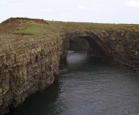
Co. Clare has one of the most dramatic landscapes in Ireland. It is famous for the unique karst region of the Burren with its unusual flora and fauna, the imposing Cliffs of Moher, and the abundant marine life along the Shannon estuary.
Much of Co. Clare is bordered by water. The River Shannon provides the border to the southeast, while Lough Derg borders the northeast. The only county in Ireland to be connected to Clare by land is Co. Galway. The highest point in Clare is found in the Slieve Bearnagh mountain range to the east, where Moylussa stands at 532m.
The most recent statistics from the Central Statistics Office (CSO) (2016) shows a population of 118,817. Much of the county is countryside, with the major urban centres at the towns of Ennis and Shannon.
County Clare is renowned for its legacy in traditional Irish music and is home to an abundance of visual riches and spectacular scenery.
Clare is located on the far west coast of Ireland, bordered by Galway Bay to the north, Lough Derg to the east, the River Shannon to the south and the Atlantic Ocean to the west. In Clare you'll find some of Ireland's most recognisable picture postcard icons, from the stunning Cliffs of Moher overlooking the Atlantic, to the Neolithic tomb, the Poulnabrone Dolman and the famous Bunratty Castle. This 13th Century castle now forms the heart of a heritage park and host world famous medieval banquets and lively entertainments.
In the far north western region of Clare is the Burren, a unique landscape of limestone karst, that in spring is awash with colourful flora. This harsh but beautiful region is popular with walkers, cyclists and cave explorers. While the sleepy villages here and in the rest of County Clare such as Doolin, Lisdoonvarna, Ennis and Feakle are renowned for their lively entertainments and festivals of traditional Irish music.
Many of Ireland's best traditional musicians and balladists have come from the Banner County as Clare is known. These include, the piper Willie Clancy and contemporary Irish musician Christie Moore and the county was famously the royal home of the last High King of Ireland, Brian Boru.
Also in County Clare you'll find the world famous Lahinch Golf Links Course and Shannon Airport, Ireland's second largest airport behind Dublin.
III. Economy
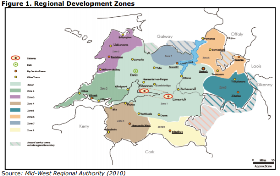
IV. Industrial Characteristics:
EIRCHEM Pharma Services Limited
Modern pharmaceutical manufacturing plant approved by FDA and EMA. Highly flexible facility located in a low-tax environment (Ireland) with multiple differentiated and highly valuable chemistry capabilities.
With broad operational experience including product launches, validation and qualification, as well as experience providing contract manufacturing services to third parties.
Excellent environment, health and safety (EH&S) record as well as a strong compliance record with regulatory authorities.
Located in Ireland, a vibrant life sciences and pharmaceutical hub that benefits from a low corporate tax rate, multiple financial incentives and a highly educated workforce.
V. Attractions
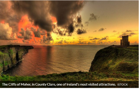
County Clare, the Banner County, is chockablock with beauty and inspiring attractions. From the Cliffs of Moher to the Burren, ancient archaeological sites, stunning wildlife and breathtaking coast – this wild and wonderful county has a wealth of attractions.
Water is certainly what defines the boundaries of the county, with the River Shannon to the southeast, Lough Derg to the northeast, the Atlantic Ocean to the west and Galway Bay to the east. The history of the county dates back to prehistoric times with several ancient tombs scattered across the land. Most famously in the Burren, at the Poulnabrone dolmen, where the remains of the people inside the tomb have been excavated and dated to 3800BC.
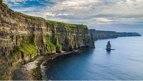
The Cliffs of Moher are Ireland’s most visited natural attraction with over one million visitors every year. The cliffs are also a Signature Discovery Point on the Wild Atlantic Way route, along the west coast of Ireland’s coast.
They stretch for 5 miles, as the crow flies, along the coast reach 214 meters (702 feet) at their highest point at Knockardakin, just north of O’Brien’s Tower.
An environmentally friendly visitor center set into the hillside, The Cliffs of Moher Visitor Experience, is located at almost the midway point along the cliffs.
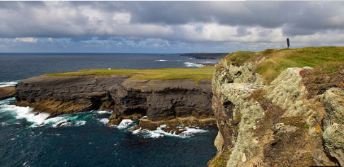
This walk circular walk from the west-end of the town of Kilkee, protected from the Atlantic Ocean by the Duggerna Reef, displays some outstanding Irish coastline.
Along the walk visitors pass the Pollock Holes, the quartz-filled Diamond Rocks and a natural stone amphitheater formed by the waves. Moving on visitors arrive at Intrinsic Bay, named after a ship, the Intrinsic, which sank along with all 14 hands on board in 1836. The trail continues up a steep climb for about 200 meters arriving at a coastal path turning inwards to Dunlicky Road.
There are also shorter walks mapped out for the less adventurous and be aware
that some areas are not suitable for strollers or wheelchairs.
VI. History
Clare is a maritime county in the province of Munster, bounded on the west by the Atlantic, on the north-west by Galway Bay and on the east and south by the river Shannon. The present county formed, from a very early period, a native principality, Tuath-Mumhan, or Thomond, signifying "North Munster". The area was divided into cantreds or baronies, each occupied by their ruling families. The O'Loughlins, O'Garbhs, O'Briens, O'Connors, O'Deas, McMahons and McNamaras were the main clans. Together, these families are generally referred to as the Dalcassian families, from Dal gCais, a name for the eastern half of the county.
The O'Briens were a major force in Thomond from earliest times. The Danish Vikings raided this county on many occasions during the 9th and 10th centuries. They were finally defeated at the beginning of the 11th century by the most famous of the O'Briens, Brian Boru, who also led the army which defeated the Danes of Dublin at Clontarf in 1014.
Following the Norman invasion, Thomond was granted to Thomas de Clare who attempted to take control of the county but was eventually defeated by the O'Briens. The O'Briens were later made Earls of Thomond and thereby remained the major force in the county for centuries. The county boundaries were established by the English administration in 1565.
Following the defeat of the 1641 rebellion of the Catholic Confederacy, Clare was set aside to accommodate the "delinquent proprietors", i.e. those proprietors whose land was confiscated because they did not actively oppose the rebellion. Parts of the lands of the existing Clare landholders were confiscated to accommodate these landholders.
The county was badly affected by the Great Famine of 1845-47. The population was 286,000 in 1841 and by 1851 had been reduced to 212,000. Over 50,000 people died between 1845 and 1850 and many emigrated, mainly to Australia. The decline in population continued during the subsequent one hundred years, falling to 73,500 in 1966. A gradual increase has been occurring since then and the 1991 census recorded a population of 91,000.
The abundance of antiquities and archaeological remains which are scattered throughout the county are a legacy to the lives of its historic and pre-historic inhabitants. County Clare has at least 2,300 earthen and stone forts, 130 megalithic tombs, 190 castles, 150 ancient churches, 3 cathedrals, 8 monasteries, 10 stone crosses, 5 round towers, besides numerous lesser monuments.
The county is fortunate in having areas of great natural beauty and superb scenery with many sandy beaches and sheltered bays. Loop Head is the most exposed promontory on the west coast and is of geological interest with some unusual rock formations. The near-by Bridges of Ross were formed by storm waves channelling into the caverns and creating natural arches which in time became separated from the mainland. The coast road around Black Head is an attractive touring route, bounded on one side by the Atlantic and the Aran Islands, and on the other by the grey hills of the Burren. The Burren region comprises 375 square miles of gently sloping carboniferous limestone landscape upon which many rare and beautiful plants thrive. The area is favoured by cavers and potholers as well as those interested in archaeology.
The majesty of the Cliffs of Moher is well known. The cliffs are also a favourite nesting ground for flocks of sea birds and up to fifty species can be seen. These include fulmars, gannets, guillemots, shags, cloughs and puffins.
In complete contrast, east Clare offers more gentle countryside, with many inviting lakes and streams. The river Shannon, and the vast expanse of Lough Derg, are host to boating and watersports of all kinds.
John Lloyd said of County Clare in 1780, "From its agreeable situation, the climate is remarkably wholesome, the air clear and temperate, and the prospect pure and delightful." Little has happened during the past two centuries to change this description. County Clare today is a place of great natural beauty and historical and archaeological interest while offering a range of amenities to suit all tastes.
VII. Other information
The custom of carrying banners goes back a long way in County Clare. There is little doubt but that the Dal gCais carried banners at the battle of Clontarf in 1014 or that the Clare Dragoons carried banners at Fontenoy in 1745 and in the many battles fought by the Clare Regiments on the continent during the eighteenth century. However, the name 'the banner county' would appear to be of far more recent origin. In the last century as population of the county became more politicized the custom of carrying banners to political meetings became widespread. Thus many banners welcomed Daniel O'Connell at the Clare election of 1828 and the freeholders of the county marched behind banners to the Ennis courthouse to cast their votes for O'Connell on that occasion.
In Ennis most trade guilds had their own banners: bakers, butchers, brogue makers, coopers, nailers, dyers, masons, harness makers, cartwrights, stone cutters etc. all competed to produce the most handsome of banners. At the inaugeration of the O'Connell monument in Ennis in 1865 thirteen different guilds carried banners, each representing the attributes of their particular trade. That this represented a long tradition in the town is not in doubt since, on that occasion, the brogue makers' guild carried a flag that had first been unfurled in 1726.
My own great grandfather, Brian Daly, was the custodian of the Ennis coopers' banner and parts of the banner are still retained by the family. The coopers' banner was not of the two pole variety that one usually sees today but was carried on a long single pole, topped by a small barrel; the banner itself hung down like a picture from a horizontal staff stretched across the top of the pole. I can recall as a child seeing the banner which was then much injured by time; it was a rusted red colour and carried the inscription 'Hearts of Oak'. This banner along with many others were carried along the streets to greet the various dignitaries that visited the town in the late nineteenth and early twentieth centuries. Politicians like Parnell and de Valera were greeted by hosts of banners. It is easy to see then in the political excitement of the times how the county acquired the name 'the banner county'. The reason the name stuck with Clare, I would suggest, was that custom of greeting politicians with banners, particularly at election time, survived longer in Clare than in other counties. The Parnellite and de Valera eras coincided with the rise of the GAA and the name soon transferred to the county's hurling and football teams.
VIII. Contact information
Mayor: John Crowe
Clare FM,Francis Street,Ennis,Co Clare,V95 FN40
Email: info@clare.fm
Phone: + 065 682 8888
Reference website: http://www.clare.fm/news/fine-gaels-arkins-is-new-mayor-of-clare/
