Quito (Ecuador) 作者: 来源: 发布时间:2021-06-03
1.Population and Area
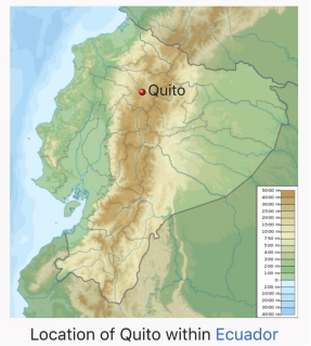
Quito is the capital of Ecuador, the country's most populous city, and at an elevation of 2,850 metres (9,350 ft) above sea level, it is the second-highest official capital city in the world, after La Paz, and the closest to the equator. It is located in the Guayllabamba river basin, on the eastern slopes of Pichincha, an active stratovolcano in the Andes Mountains.
Area (approx.): 372.39 km2 (143.78 sq mi)
Population (2020): 2,011,388
2. Geography
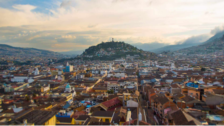
Quito is located in the northern highlands of Ecuador in the Guayllabamba river basin. The city is built on a long plateau lying on the east flanks of the Pichincha volcano. The valley of Guayllabamba River where Quito lies is flanked by volcanoes, some of them snow-capped, and visible from the city on a clear day. Quito is the closest capital city to the equator. Quito's altitude is listed at 2,820 metres (9,250 feet).
Nearby volcanoes
Quito's closest volcano is Pichincha, looming over the western side of the city. Quito is the only capital city directly menaced by an active volcano. Pichincha volcano has several summits, among them Ruku Pichincha at 4,700 metres (15,400 feet) above sea level and Guagua Pichincha at 4,794 metres (15,728 feet). Guagua Pichincha is active and being monitored by volcanologists at the Geophysical institute of the national polytechnic university. The largest eruption occurred in 1660 when more than 25 centimetres (9.8 inches) of ash covered the city. There were three minor eruptions in the 19th century. The latest eruption was recorded on October 5, 1999, when a few puffs of smoke and much ash were deposited on the city.
Activity in other nearby volcanoes can also affect the city. In November 2002 the volcano Reventador erupted and showered the city in fine ash particles, to a depth of several centimeters.
The volcanoes on the Central Cordillera (Royal Cordillera), east of Quito, surrounding the Guayllabamba valley include Cotopaxi, Sincholagua, Antisana and Cayambe. Some of the volcanoes of the Western Cordillera, to the west of the Guayllabamba valley, as well as are Pichincha include Illiniza, Atacazo, and Pululahua (which has the Pululahua Geobotanical Reserve).
Topographical zones
Quito is divided into three areas, separated by hills:
1) Central: houses the colonial old city.
2) Southern: is mainly industrial and residential, and a working-class housing area.
3) Northern: is the modern Quito, with high-rise buildings, shopping centres, the financial district, and upper-class residential areas and some working-class housing areas.
Transportation
Public transportation
The MetrobusQ network, also known as "Red Integrada de Transporte Público", is the bus rapid transit system running in Quito, and it goes through the city from south to north. It's divided into three sections—the green line (the central trolleybus, known as El Trole), the red line (the north-east Ecovía), and the blue line (the north-west Corridor Central). In addition to the bus rapid transit system, there are many buses running in the city. The buses have both a name and a number, and they have a fixed route. Taxi cabs are all yellow, and they have meters that show the fare. There are nearly 8,800 registered taxicabs.
In August 2012 the Municipality of Quito government established a municipal bicycle sharing system called Bici Q.
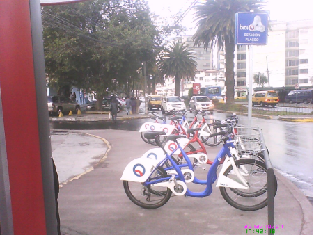
Bici Q station in northern Quito.
Highway transportation
Although public transportation is the primary form of travel in the city, including fleets of taxis that continually cruise the roadways, the use of private vehicles has increased substantially during the past decade. Because of growing road congestion in many areas, there were plans to construct a light rail system, which were conceived to replace the northern portion of the Trole. These plans have been ruled out and replaced by the construction of the first metro line (subway) in 2012. It is expected to be operational by March 2020, joining the existing public transportation network.
Roads, avenues and streets
Because Quito is about 40 km (25 mi) long and 5 km (3.1 mi) at its widest, most of the important avenues of the city extend from north to south. The two main motorways that go from the northern part of the city to the southern are Avenue Oriental (Corridor Periférico Oriental) on the eastern hills that border the city, and Avenue Occidental on the western side of the city on the Pichincha volcano. The street 10 de Agosto also runs north to south through most of the city, running down the middle of it. The historic centre of the city is based on a grid pattern, despite the hills, with the streets Venezuela, Chile, García Moreno, and Guayaquil being the most important.
Air transportation
The Mariscal Sucre International Airport serves as the city's principal airport for passenger travel and freight. The airport is located 18 kilometres (11 mi) east of the city's centre in the Tababela parish. It began operations on February 20, 2013, replacing the Old Mariscal Sucre International Airport located 10 kilometres (6.2 mi) north of the city centre within city limits. The old airport was replaced due to tall buildings and nighttime fog that made landing from the south difficult. The old airport has become a metropolitan park.
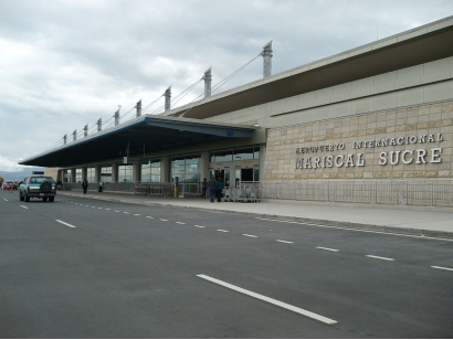
Mariscal Sucre International Airport
Rail transportation
There is a railroad that goes through the southern part of Quito and passes through the Estación de Chimbacalle. It is managed by the Empresa de Ferrocarriles Ecuatorianos (EFE). This form of transportation is nowadays used mostly for tourism.
Subway
A 23 kilometres (14 mi) metro subway system (Quito Metro) is under construction. Phase One, begun in 2013, entailed the construction of stations at La Magdalena and El Labrador. Phase Two, begun in 2016, involves 13 more stations, a depot and sub-systems. The project is expected to carry 400,000 passengers per day and to cost $1.5 billion with financing coming from the World Bank, the Inter-American Development Bank (IDB), the European Investment Bank (EIB) and the Development Bank of Latin America (CAF) and is expected to be operating in 2020.
3. Economy
Quito is the largest city in contribution to national GDP, and the highest in per capita income. Quito has the highest level of tax collection in Ecuador, exceeding the national 57% per year 2009, currently being the most important economic region of the country, as the latest "study" conducted by the Central Bank of Ecuador.
4. Industries and enterprises
The top major industries in Quito includes textiles, metals and agriculture, with major crops for export being coffee, sugar, cacao, rice, bananas and palm oil. Headquarters and regional offices of many national and international financial institutions, oil corporations and international businesses are also located in Quito, making it a world class business city.
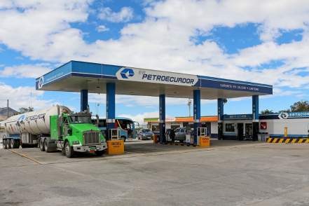
Petroecuador, the largest company in the country and one of the largest in Latin America is headquartered in Quito.
Petroecuador is a state-owned enterprise, founded on September 26, 1989. It is engaged in the exploration, production, storage, refining of crude oil, and retailing petroleum products. It operates through subsidiaries, such as Petroproduccion (exploration and production), Petroindustrial (refining), and Petrocomercial (transportation and marketing of refined products). The company operates several oil fields, including Shushufindi, Sacha, Auca, Lago Agrio, and Libertador. It also operates the Trans-Ecuadorian oil pipeline network, Sistema de Oleoducto Transecuatoriano (SOTE), built in 1972 for Texaco-Gulf. Ecuador is the fifth largest oil producer in the Latin American region.
Petroecuador owns three petroleum refineries in Ecuador:
1) Esmeraldas Refinery,110,000 barrels per day (17,000 m3/d) (began 1978)
2) La Libertad Refinery, 45,000 barrels per day (7,200 m3/d)
3) Shushufindi Refinery, 20,000 barrels per day (3,200 m3/d)
5. Tourist attractions
Historic center
Quito has the largest, least-altered, and best-preserved historic center in the Americas. This center was, together with the historic center of Kraków in Poland, the first to be declared a World Heritage Site by UNESCO on 18 September 1978. The Historic Centre of Quito is to the south of the capital's current center, on an area of 320 hectares (790 acres), and is one of the most important historic areas in Latin America. There are about 130 monumental buildings (which host a variety of pictorial art and sculpture, mostly religiously-inspired, in a multi-faceted range of schools and styles), and 5,000 properties registered in the municipal inventory of heritage properties.
The Church of El Sagrario in the historic center
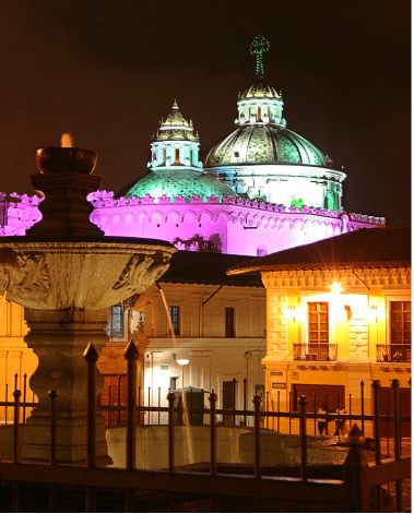
Basilica del Voto Nacional
The monumental Basilica del Voto Nacional is the most important neo-Gothic building in Ecuador, and one of the most representative of the American continent. It was once the largest in the New World.
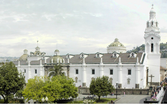
Cathedral of Quito
The Cathedral of Quito, is one of the largest religious symbols of spiritual value for the Catholic community in the city. Construction of this church began in 1562, seventeen years after the Diocese of Quito was created in 1545. The church building was completed in 1806, during the administration of President of the Real Audiencia, Baron Héctor de Carondelet.
One of the major events that took place in this cathedral was the murder of the Bishop of Quito, José Ignacio Checa y Barba, who during the mass of Good Friday on 30 March 1877, was poisoned by strychnine dissolved in the consecrated wine. The cathedral is also the burial place of the remains of the Grand Marshal Antonio José de Sucre and also of several presidents of the Republic, as well as of bishops and priests who died in the diocese. The cathedral is on the south side of the Plaza de La Independencia.
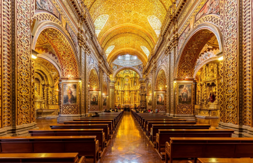
Church of La Compañía de Jesús
Construction of The Church of La Compañía began in 1605. Building took 160 years. In 1765 the work was completed with the construction of the façade. This was done by Native Americans who carefully shaped the stones to build the façade in the ornate Baroque style, in what is one of the finest examples of this art in the Americas.
6. History
Pre-Columbian period
The oldest traces of human presence in Quito were excavated by American archaeologist Robert E. Bell in 1960, on the slopes of the Ilaló volcano, located between the eastern valleys of Los Chillos and Tumbaco. Hunter-gatherers left tools of obsidian glass, dated to 8000 BC. This archaeological site, called EI Inga, was brought to Robert Bell's attention by Allen Graffham. While employed as a geologist in Ecuador, Mr. Graffham pursued his amateur interest in archaeology, and he made surface collections at the site during 1956. The discovery of projectile points, particularly specimens with basal fluting, stimulated his interest, and he made several visits to the site to collect surface materials. Graffham's previous interest in Paleo-Indian remains, and his experience with early man materials in Kansas and Nebraska in the Central Plains of the United States, led him to believe that the site was an important discovery.
The second important vestige of human settlement was found in the current neighborhood of Cotocollao (1500 BC), northwest of Quito. The prehistoric village covered over 26 hectares in an area irrigated by many creeks. Near the ancient rectangular houses there are burials with pottery and stone offerings. The Cotocollao people extracted and exported obsidian to the coastal region.
Colonial period
Indigenous resistance to Spanish colonization continued during 1534, with the conquistador Diego de Almagro founding Santiago de Quito (in present-day Colta, near Riobamba) on 15 August 1534, renamed as San Francisco de Quito on 28 August 1534. The city was later refounded at its present location on 6 December 1534 by 204 settlers led by Sebastián de Benalcázar, who captured Rumiñahui and effectively ended all organized resistance. Rumiñahui was then executed on January 10, 1535.
On 28 March 1541 Quito was declared a city, and on 23 February 1556 it was given the title Muy Noble y Muy Leal Ciudad de San Francisco de Quito ("Very Noble and Loyal City of San Francisco of Quito"), marking the start of its urban evolution. In 1563 Quito became the seat of a Real Audiencia (administrative district) of Spain and part of the Viceroyalty of Peru until 1717, after which the Audiencia was part of the new Viceroyalty of Nueva Granada. Under both Viceroyalties the district was administered from Quito.
The Spanish established Roman Catholicism in Quito. The first church (El Belén) was built even before the city was officially founded. In January 1535 the San Francisco Convent was constructed, the first of about 20 churches and convents built during the colonial period. The Spanish converted the indigenous population to Christianity and used them as labor for construction.
In 1743, after nearly 210 years of Spanish colonization, Quito was a city of about 10,000 inhabitants. On 10 August 1809 a movement was started in Quito to win independence from Spain. On that date a plan for government was established, which appointed Juan Pío Montúfar as president and prominent pro-independence figures in other government positions. However, this initial movement was ultimately defeated on 2 August 1810, when colonial troops arrived from Lima, Peru, and killed the leaders of the uprising and about 200 other settlers. A chain of conflicts climaxed on 24 May 1822, when Antonio José de Sucre, under the command of Simón Bolívar, led troops into the Battle of Pichincha. Their victory won the independence of Quito and the surrounding areas.
Republican Ecuador
In 1833 members of the Society of Free Inhabitants of Quito were assassinated by the government after they conspired against it. On 6 March 1845 the Marcist Revolution began. In 1875 the country's president, Gabriel García Moreno, was assassinated in Quito. Two years later, in 1877, Archbishop José Ignacio Checa y Barba was killed by poison while celebrating Mass in Quito.
In 1882 insurgents rose up against the regime of dictator Ignacio de Veintimilla. However, this did not end the violence that was occurring throughout the country. On 9 July 1883 the liberal commander Eloy Alfaro participated in the Battle of Guayaquil, and after further conflict he became the president of Ecuador on 4 September 1895. Upon completing his second term in 1911, he moved to Europe. He returned to Ecuador in 1912 and attempted to return to power unsuccessfully; he was arrested on 28 January 1912, thrown in prison, and assassinated by a mob that stormed the prison. His body was dragged through the streets of Quito to a city park, where it was burned.
In 1932 the Four Days' War broke out. This was a civil war that followed the election of Neptalí Bonifaz and the subsequent realization that he carried a Peruvian passport. On 12 February 1949 a realistic broadcast of H. G. Wells' novel The War of the Worlds led to citywide panic, and the deaths of more than twenty people who died in fires set by mobs.
21st century
In 2011 the city's population was 2,239,191 people. Since 2002 the city has been renewing its historical center. The old airport was closed to air traffic on 19 February 2013 and then transformed into the "Parque Bicentenario" (Bicentenary Park). The new Mariscal Sucre International Airport, 45 minutes from central Quito, opened to air traffic on 20 February 2013.
During 2003 and 2004, the bus lines of the Metrobus (Ecovia) were constructed, traversing the city from the north to the south. Many avenues and roads were extended and enlarged, depressed passages were constructed, and roads were restructured geometrically to increase the flow of traffic. A new subway system is currently under construction.
Culture
Quito is a city with a mix of modern-day and traditional culture. There is a large Catholic presence in Quito; most notably, Quito observes Easter Week with a series of ceremonies and rituals that begin on Palm Sunday. At noon on Good Friday, the March of the Penitents proceeds from the Church of San Francisco.
7. Other information
Quito and Kraków, Poland, were the first World Cultural Heritage Sites declared by UNESCO, in 1978.
In 2008, the city was designated as the headquarters of the Union of South American Nations.
In "The World according to GaWC" global cities report, which measures a city's integration into the world city network, Quito is ranked as a Beta city: an important metropolis instrumental in linking its region or state into the world economy.
8. Contact
Website: www.quito.gob.ec
Mayor: Jorge Yunda
Tel: (593-2) 3952300
Email: serviciosciudadanos@quito.gob.ec
Address of the municipal government(Municipio del Distrito Metropolitano de Quito):
Venezuela entre Espejo y Chile, Venezuela, Quito 170101, Ecuador
