Valladolid, Yucatán 作者: 来源: 发布时间:2021-11-19
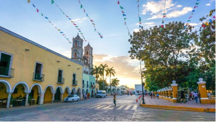
1.Population and Area
Pop: 48,973 (city)
Area: 1.117 km2 (city)
Elev: 9 masl
2. Natural geography
Nature and weather
Orography
Its terrain is flat, of the type known as a barrier plain with rocky floors.
Hydrography
In the municipal territory there are no surface water currents. However, there are underground streams that form deposits commonly known as cenotes.
In some cases the roofs of these collapse and form the aguadas. They stand out for their natural beauty, as well as for the care and maintenance provided by the municipal authorities, the Zací cenote located at the head, and the cave and cenote Dzitnup six kilometers southwest of Valladolid from this head.
Flora and fauna
The flora preserves the characteristic of the medium subdeciduous forest with secondary vegetation. The main species are: mahogany, cedar, ceiba, chakah, bojom, kanisté, chichibé and pochote, among others.
Regarding the fauna, the population includes some varieties of reptiles (corals, mousetraps and rattles, mainly), amphibians (frogs and toads) and birds (quail, turtledove and pigeon).
Köppen Classification: Tropical and Subtropical Steppe Climate
Tropical savanna climates have monthly mean temperature above 18°C (64°F) in every month of the year and typically a pronounced dry season, with the driest month having precipitation less than 60mm (2.36 in) of precipitation. In essence, a tropical savanna climate tends to either see less rainfall than a tropical monsoon climate or have more pronounced dry seasons than a tropical monsoon climate. Tropical savanna climates are most commonly found in Africa, Asia and South America. The climate is also prevalent in sections of Central America, northern Australia and North America, specifically in sections of Mexico and the state of Florida in the United States.
The Köppen Climate Classification subtype for this climate is "Aw". (Tropical Savanna Climate).
The average temperature for the year in Valladolid is 77.9°F (25.5°C). The warmest month, on average, is May with an average temperature of 81.9°F (27.7°C). The coolest month on average is December, with an average temperature of 72.7°F (22.6°C).
The highest recorded temperature in Valladolid is 104.9°F (40.5°C), which was recorded in April. The lowest recorded temperature in Valladolid is 38.5°F (3.6°C), which was recorded in February.
The average amount of precipitation for the year in Valladolid is 48.1" (1221.7 mm). The month with the most precipitation on average is September with 8.0" (203.2 mm) of precipitation. The month with the least precipitation on average is March with an average of 1.3" (33 mm). In terms of liquid precipitation, there are an average of 106.8 days of rain, with the most rain occurring in August with 16.0 days of rain, and the least rain occurring in March with 2.2 days of rain.
http://www.weatherbase.com/weather/weather-summary.php3?s=766470&cityname=Valladolid%2C+Yucatan%2C+Mexico&units=
Getting there and around
Get there
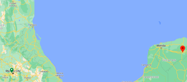
By plane – The cheapest way to get from Mexico City to Valladolid is to fly and shuttle which costs $950 - $2600 and takes 5h 41m. The quickest flight from Mexico City Airport to Merida Airport is the direct flight which takes 1h 45m.
By car – The distance between Mexico City and Valladolid is 1150 km. The road distance is 1460.6 km. It takes approximately 17h 50m to drive from Mexico City to Valladolid.
By bus – The cheapest way to get from Mexico City to Matehuala is to bus which costs $600 - $1500 and takes 7h 39m. there are services departing from Mexico City and arriving at Valladolid via Mérida. The journey, including transfers, takes approximately 24h 38m.
https://www.rome2rio.com/s/Mexico-City/Valladolid-Yucat%C3%A1n-Mexico
Rideshare – Check out Blabla Car's carpooling service for rideshare options between Mexico City and the city you are visiting. A great option if you don't have a driver's license or want to avoid public transport.
Car Rental – To explore Mexico’s provincial towns and cities—including its beach locations and the scenery and attractions near them— consider renting a car for your visit. Having your own car will give you more flexibility than using public transport options and, in some cases, offer you access to places which are otherwise difficult to visit without the use of a car.
COVID19 – International entry into Mexico from United States
Allowed for: All visitors arriving by air. Mexico land borders are closed to non-essential travel
Restricted for: There are no current restrictions.
Get around
Local Buses – Local buses and mini-buses (combis or micros) are available locally for a fraction of the cost of a taxi around town. You need to speak Spanish to be able to ask for directions or ask the driver to tell you where to get off.
Taxis – Taxis in most of Mexico’s towns and cities are not metered, so agree your price before you get in. Taxi travel is very affordable in Mexico, in comparison to the USA, Canada and Europe, and so provides a viable means of public transportation in Mexico. Your hotel can arrange taxis for you; some post their rates on a board in the lobby; taxi hotel rates are usually higher than cabs you hail off the street. If you speak Spanish, you will have a distinct advantage and be able to negotiate a price with the driver.
Uber is expanding rapidly across Mexico and now offers services in cities across the country, including: Mexico City, Toluca, Cuernavaca, Puebla, Querétaro, León, Aguascalientes, San Luis Potosí, Guadalajara, Monterrey, Hermosillo, Tijuana, Mexicali, and Mérida. Uber has been adding Mexican cities to its network every year, check for availability when you arrive at your destination in Mexico.
Cabify and Didi are also developing and currently operate in cities including Mexico City, Toluca, Monterrey, Puebla, Querétaro and Tijuana. Check for availability in the city you are visiting.
These services offer people with smartphones a way to book a cab through a mobile app for a pre-agreed price. Fares are comparable with Sitio type cabs, and sometimes trade at a premium to this when local demand increases.
https://www.mexperience.com/transport/taxi-travel-in-mexico/#51
3. ECONOMY
GDP: 3525.4 M MXN (2010)
https://www.researchgate.net/publication/323024280_El_producto_interno_bruto_de_los_municipios_de_Mexico_II_Estados_M-Z
4. Industry characteristics
The municipality is the third in economic importance in the state of Yucatán, only after Mérida and Tizimín. The main municipal productive activities are agriculture (corn, vegetables), livestock (cattle), the manufacture of handicrafts, commerce and tourism. It has a privileged geographical location as it is incorporated into the main state highway axis (Mérida-Cancun), which links it with these two poles of regional development and the important archaeological zones of Chichén Itzá, Tulum and Cobá. The municipality also has its own archaeological sites that are an important tourist attraction: Kumal, Xkuxil, Xkakuil, Dzoyolá and Xkax, are among the most important.
Employment
The economically active population of the town was 19,468 inhabitants in 2010, of these, 12,808 were men and 6,660 women. However, only 18,890 people were employed, 12,346 men and 6,544 women.
Primary sector
The primary sector occupied 19% of the economically active population of the municipality in 2000.27 Most of the primary activities are developed by local producers.
Secondary sector
The secondary sector occupied 32% of the economically active population of the municipality in 2000.
Third sector
The tertiary sector occupied 48% of the economically active population of the municipality in 2000.
Key project: Mayan Train Station in Valladolid municipality

The Mayan Train is a project of the federal government of Mexico to transport passengers and cargo through the Yucatan Peninsula as part of the expansion of the national rail network. This infrastructure work has been under development since December 2018, previously announced by Andrés Manuel López Obrador during his campaign for the presidency of Mexico. It is planned as a regional train for locals, tourists and cargo that begins operations in 2024.
The station project will be located in the south of the city. The demand for passengers will be intermediate and will have a tourist and social character, considering a 3-way and 2-platform scheme at the station.
The Mayan Train track in the section from Chichen Itzá to Valladolid, which will run on the south lane of the federal toll highway, is being built without obstacles, since the ICA company that was awarded the work is also concessioning the track. Company personnel are already working on prospecting and topographic surveying.
Unlike other sections that have been considered problematic, due to archaeological remains, bodies of water and other obstacles that the roads may encounter in their path.
The plan is to use the south lane of the highway, on which the train tracks would run and with this it is expected that there will be no major obstacles, except for some areas that would have to be expanded a bit.
The other side of the highway will be widened to have 4 lanes for vehicles and the central part of the highway could be used, but for this the topographic survey is being carried out, which is essential to define the final design of the section.
https://www.trenmaya.gob.mx/estacion-valladolid
https://www.poresto.net/tren-maya/2020/9/30/sin-obstaculos-avanza-la-construccion-de-la-estacion-del-tren-maya-en-valladolid-148777.html
5. Attractions
San Bernardino de Sienta Former Convent

From Wednesday to Sunday, the San Bernardino de Siena Former Convent is modernized in its outside for the sound and light show: “Nights from the Heroic Valladolid”. Here you will learn in an amusing way about the history of the city and its importance for the peninsula of Yucatán. This is a free show so the only thing you have to do is sit in one of the seats spread across the atrium and garden of the temple.
You will see the arrival of the Spanish Conquistadores, the construction of the former convent and the splendor of Valladolid to this day. You will also watch scenes from typical dances like jarana, the beauty and complexity of its handmade typical clothes and of its antique barrios. All this is just a tiny part of the heritage of the Pueblo Mágico (Magical Town) of Valladolid.
In addition, if you want to get to know about the history of San Bernardino de Siena, you can take a guided tour. It is one of the oldest temples in the peninsula and the biggest after the Former Convent of San Antonio de Padua in Izamal. Its notary 's office is built on top of the cenote (a natural water pool), Sis Há, an important place as it helped in the evangelization of the Mayan population
https://www.visitmexico.com/en/yucatan/valladolid/san-bernardino-de-sienta-former-convent
Ek Balam
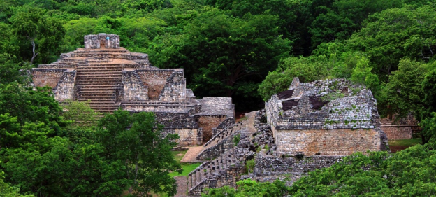
The vestiges of this archeological zone are hidden in the jungle, just half an hour from Valladolid. Its splendour lies in its steles, ramparts and sumptuous palaces that were built in the Pre Classical period, before the arrival of the Spanish Conquistadors.
Ek Balam is an example of how the Mayan population was connected with other cities through its sacbés, white sand roads that shine in the dark. Precisely, these roads are the ones that will get you to the archeological zone and to its basement.
Now, the Acropolis deserves your complete attention. Here you will find a sumptuous palace of 31 meters in height. It is conformed by different rooms with vaults. The facade is rounded off with two humongous canines that emulates a jaguar snout. You can also find winged sculptures with Mayan faces.
You can see an ancient offering dedicated to Ukit Kan Lek Tok. Some of the objects that you will see are shells, jade chest-ornaments, ear pieces and collars.
In another area you can see masks, friezes and stone statues that allude to the jaguar and to its former rulers.
https://www.visitmexico.com/en/yucatan/valladolid/ek-balam
Cenotes
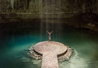
The hot and humid weather of the Pueblo Mágico (Magical Town) of Valladolid, Yucatán, is idoneous for a tour through its cenotes; natural water pools of unbelievable beauty. It is easy to get to any of these caverns that are open to the public.
The cenote Zici is a cavern with half a roof collapsed. It is located in the heart of the Historical Center of Valladolid. The vegetation in its walls and the numerous stalactites make it a very special place. Its depth ranges from 25 to 100 mtrs, so it is advisable to use lifejackets. You can also use a zipline for going through it.
Cenote Oxman is located in The Hacienda San Lorenzo Oxman, five minutes distance from Valladolid. After you go down through the wooden stairs , you will be able to swim in its crystalline blue waters. Take a look to its diverse bird variety and to its extraordinary vines.
In the cenote Dzitnup you will actually find two of them: Samulá y X’kekén. You can get to the first one through spiral stairs . X’kekén is an almost closed cenote with just a tiny hole that will only allow you to get in along with the sunlight.
Cenote Suytun is probably the most photographed of all in valladolid. A natural platform allows you to appreciate the blue color of its water. There are cottages that connect you directly with this water pool.
In the Cenote Choj-Há you can make rapel, besides swimming. You can also make a kayak tour here. This cenote is located quite close to the Santa Rosa grotto.
Finally, if you go to X’canché, you can practise rappel, kayak and try the zipline. There’s also bike rental to get to the archaeological zone Ek Balam.
https://www.visitmexico.com/en/yucatan/valladolid/cenotes
Museums
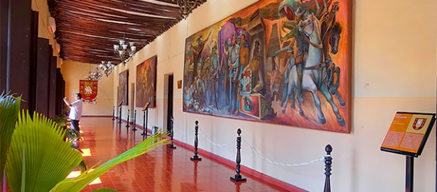
Valladolid is a Pueblo Mágico (Magical Town) full of rich in traditions and with an extensive legacy of its Mayan roots. And the next two examples will suffice to prove it.
The San roque Museum is located in the premises that were used as the general hospital of Valladolid. In addition, it served as well as the first electric plant in the city.
Inside its terracotta walls you will find 4 rooms that display the Prehispanic life in the city, with objects found during the Ek Balam excavations. Next room is about the city’s foundation and other important historical moments such as The War of the Castes and Pyrate slike the famous “Lorencillos”. In another room, you can get to know more about Mayan medicine, traditions and its crafts.
At the MUREM (Ethnic Clothing Museum) you can learn about different cultures in the country, with an emphasis in its textile legacy. You will find more than 900 typical costumes designed by ethnic groups around the country. In this regard, you can learn about especifical technical issues related to the decoration of clothing like hand embroidery techniques among many more.
You can find both museums at 41 street, at the Historical Center of Valladolid.
https://www.visitmexico.com/en/yucatan/valladolid/museums
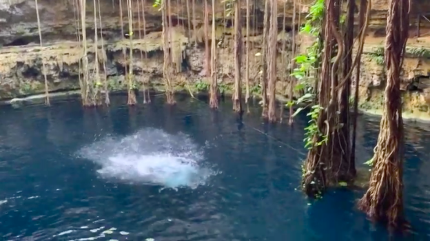
Exploring Valladolid in Yucatan, Mexico
https://youtu.be/HhjZgwX6u4A
6. History
Named after Valladolid, at the time the capital of Spain. The name derives from the Arabic expression Ballad Al-Walid بلد الوليد, which means "city of Al-Walid", referring to Al-Walid I. the first Valladolid in Yucatán was established by Spanish Conquistador Francisco de Montejo's nephew on May 27, 1543 at some distance from the current town, at a lagoon called Chouac-Ha in the municipality of Tizimin. However, early Spanish settlers complained about the mosquitos and humidity at the original location and petitioned to have the city moved further inland.
On March 24, 1545, Valladolid was relocated to its current location, built atop a Maya town called Zaci or Zaci-Val, whose buildings were dismantled to reuse the stones to build the Spanish colonial town. The following year the Maya people revolted but were put down with additional Spanish troops coming from Mérida.
In 1705 there was a revolt by local Maya; the rebels killed a number of town officials who had taken refuge in the Cathedral. When the revolt was suppressed, the Cathedral was considered irreparably profaned, and was demolished. A new Cathedral was built the following year that still exists; it was oriented to face north unlike most other Colonial churches in Yucatan which face east.
Valladolid had a population of 15,000 in 1840. In January 1847, the native Mayans rioted, killing some eighty whites and sacking their houses. After a Mayan noble was shot by firing squad, the riot became a general uprising. It was led by Jacinto Pat, batab of Tihosuco and by Cecilio Chi of nearby Ichmul.[4] The city and the surrounding region was the scene of intense battle during Yucatán's Caste War, and the Ladino forces were forced to abandon Valladolid on March 14, 1848, with half being killed by ambush before they reached Mérida. The city was sacked by the Maya rebels but was recaptured later in the war.
Until the beginning of the 20th century, Valladolid was the third largest and most important city of the Yucatán Peninsula, (after Mérida and Campeche). It had a sizable well-to-do Criollo population, with a number of old Spanish style mansions in the old city. Valladolid was widely known by its nickname The Sultana of the East.
7.Contact Information
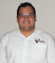
City Mayor: Enrique de Jesús Ayora Sosa
Phone number: +52 (985) 85 6 2551
Facebook: https://www.facebook.com/enriqueayorasosa
Twitter: https://twitter.com/ejas_24
E-mail: enrique.ayora@valladolid.gob.mx
Website: http://valladolid.gob.mx
Govt. Office Address: Calle 40 No. 200 x 41, Col. Centro Histórico, CP. 97780, Valladolid, Yucatán
