Los Mochis, Sinaloa 作者: 来源: 发布时间:2021-11-18
1.Population and Area
Pop: 256,613 (city)
Area: 61.242 km2 (city)
Elev: 10 masl
2. Natural geography
Nature and weather
Orography
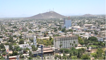
The terrain of Los Mochis in general is flat, with the presence of low elevation mountains. It is located in the Valle del Fuerte. Its average altitude is 10 meters above sea level. Its high points are the Cerro de la Memoria (160 m), the two hills where Loma Dorada Residencial is (90 m and 70 m), and the hill where the facilities of what was the Hotel Colinas are (50 m).
Flora and fauna
Its soils are characterized by the proliferation of grasses, shrubs, chaparrals and tropical vegetation, such as Washingtonia, Roystonea, and Sabal palms.
Among its mammals we find the opossum, wild boar, white-tailed deer, among others, as well as iguanas, crocodiles and turtles. Among the birds are the sparrow, pigeons.
Köppen Classification: Mid-Latitude Steppe and Desert Climate
This climate type is characterized by extremely variable temperature conditions, with annual means decreasing and annual ranges increasing poleward, and relatively little precipitation. This climate is typically located deep within the interiors of continents and is contiguous with the tropical desert climates of North and South America and of central Asia. This region type owes its origins to locations deep within continental interiors, far from the windward coasts and sources of moist, maritime air. Remoteness from sources of water vapor is enhanced in some regions by mountain barriers upwind.
The Köppen Climate Classification subtype for this climate is "Bsh". (Mid-Latitude Steppe and Desert Climate).
The average temperature for the year in Los Mochis is 77.9°F (25.5°C). The warmest month, on average, is July with an average temperature of 88.7°F (31.5°C). The coolest month on average is January, with an average temperature of 66.0°F (18.9°C).
The highest recorded temperature in Los Mochis is 118.4°F (48°C), which was recorded in September. The lowest recorded temperature in Los Mochis is 36.5°F (2.5°C), which was recorded in January.
The average amount of precipitation for the year in Los Mochis is 13.0" (330.2 mm). The month with the most precipitation on average is August with 3.5" (88.9 mm) of precipitation. The month with the least precipitation on average is April with an average of 0.0" (0 mm). In terms of liquid precipitation, there are an average of 32.1 days of rain, with the most rain occurring in August with 8.7 days of rain, and the least rain occurring in May with 0.2 days of rain.
http://www.weatherbase.com/weather/weather-summary.php3?s=16367&cityname=Los+Mochis%2C+Sinaloa%2C+Mexico&units=
Getting there and around
Get there
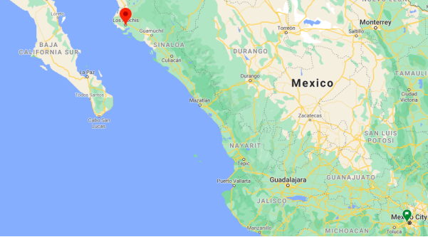
By plane – The quickest way to get from Mexico City to Los Mochis is to fly which costs $1400 - $3800 and takes 3h 55m. The quickest flight from Mexico City Airport to Los Mochis Airport is the direct flight which takes 2h 14m.
By car – The distance between Mexico City and Los Mochis is 1235 km. The road distance is 1408.8 km. It takes approximately 14h 45m to drive from Mexico City to Los Mochis.
By bus – The cheapest way to get from Mexico City to Los Mochis is to bus via Los Mochis which costs $1000 - $1800 and takes 20h. There are services departing from Izazaga and arriving at Los Mochis via Mexico City North.
https://www.rome2rio.com/s/Mexico-City/Los-Mochis
Rideshare – Check out Blabla Car's carpooling service for rideshare options between Mexico City and the city you are visiting. A great option if you don't have a driver's license or want to avoid public transport.
Car Rental – To explore Mexico’s provincial towns and cities—including its beach locations and the scenery and attractions near them— consider renting a car for your visit. Having your own car will give you more flexibility than using public transport options and, in some cases, offer you access to places which are otherwise difficult to visit without the use of a car.
COVID19 – International entry into Mexico from United States
Allowed for: All visitors arriving by air. Mexico land borders are closed to non-essential travel
Restricted for: There are no current restrictions.
Get around
Local Buses – Local buses and mini-buses (combis or micros) are available locally for a fraction of the cost of a taxi around town. You need to speak Spanish to be able to ask for directions or ask the driver to tell you where to get off.
Taxis – Taxis in most of Mexico’s towns and cities are not metered, so agree your price before you get in. Taxi travel is very affordable in Mexico, in comparison to the USA, Canada and Europe, and so provides a viable means of public transportation in Mexico. Your hotel can arrange taxis for you; some post their rates on a board in the lobby; taxi hotel rates are usually higher than cabs you hail off the street. If you speak Spanish, you will have a distinct advantage and be able to negotiate a price with the driver.
Uber is expanding rapidly across Mexico and now offers services in cities across the country, including: Mexico City, Toluca, Cuernavaca, Puebla, Querétaro, León, Aguascalientes, San Luis Potosí, Guadalajara, Monterrey, Hermosillo, Tijuana, Mexicali, and Mérida. Uber has been adding Mexican cities to its network every year, check for availability when you arrive at your destination in Mexico.
Cabify and Didi are also developing and currently operate in cities including Mexico City, Toluca, Monterrey, Puebla, Querétaro and Tijuana. Check for availability in the city you are visiting.
These services offer people with smartphones a way to book a cab through a mobile app for a pre-agreed price. Fares are comparable with Sitio type cabs, and sometimes trade at a premium to this when local demand increases.
https://www.mexperience.com/transport/taxi-travel-in-mexico/#51
3. ECONOMY
GDP: 57,975 M MXN (2010)
https://imco.org.mx/ciudades2010/ciudades/74_Losmochis.html
4. Industry characteristics
Farming
Agriculture is one of the main economic activities that takes place around the city. Agriculture is highly technical and has an area of 174 thousand 468 hectares (40.17% of the total municipal area), with 9 thousand 904 units of rural production. It is estimated that 151 thousand 485 hectares are irrigated, and 22 thousand 983 of rainfed and irrigation. The agriculture of the municipality has among its main crops those of potatoes, wheat, beans, chickpeas, soybeans, sugar cane, cotton, safflower, tomato, corn, sorghum, rice, tomatillo, squash and marigold.
Commerce
Regarding the formal and informal commercial infrastructure, there are 4,543 establishments, 17% of the total existing in the state. Self-service stores, department stores, shopping centers, municipal markets, food markets with more than 200 stores stand out. commercial.
Cattle raising
It is developed in 66,200 hectares, where there are approximately 189,500 head of cattle. It occupies 7.41% of the productivity of the municipality. The livestock production that stands out for its number and value is cattle, pigs, sheep, goats, and poultry farming has approximately 2,050,000 birds with a total production of 32,000 tons of feed per year. Beekeeping has more than 2,000 hives, producing 30 tons of stalk honey and 25 tons of wax per year.
Industry
The industrial development that is generated in this area plays a vital role in the flow of capital in the region, the growing industry contributes enormously to the economy of Sinaloa. There are 800 industrial establishments, among which the number of those belonging to the automotive sector (electrical harnesses), metal mechanics, bodywork, various repair shops and textiles as well as assembly companies and distribution centers stand out; 89% of these are family micro-businesses that are grouped into 20 industrial lines. It has extensive industrial areas such as: Santa Rosa Industrial Park, Jiquilpan Industrial Zone, Dissa Industrial Park, Mochis-Topolobampo Industrial Corridor, Mochis-Guasave Industrial Corridor, Topolobampo Industrial Park, Topolobampo Fishing Industrial Park.
5. Attractions
Regional Museum of the Valley of El Fuerte
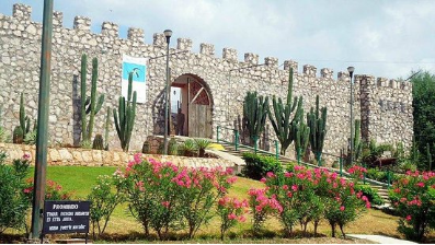
The El Fuerte Valley Regional Museum has an important collection of historical, social and cultural events in the El Fuerte Valley region, north of the state. It includes in its permanent exhibition a collection of pieces from the Yoreme Culture, also known as Mayo, as well as information related to this indigenous group, the one with the greatest cohesion and presence in the state.
It offers services of temporary exhibitions, guided visits, historical information, orientation, artistic workshops, and shows among other cultural activities; as well as the services of a bookstore specialized in editions of authors of the state.
The museum has six exhibition rooms, four of them permanent and two temporary, which receive an average of 15 exhibitions per year. The Museum offers educational services for children through reading and writing courses, guided tours, concerts, conferences and editorial presentations are offered to the general public.
http://www.culturasinaloa.gob.mx/index.php?option=com_content&view=article&id=10:museo-regional-del-valle-de-el-fuerte&catid=100&Itemid=101
The Remembrance Hill Pergola
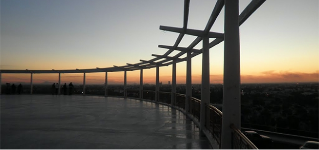
The need to introduce drinking water to the city of Los Mochis gave rise to a design and work considered emblematic in the locality: La Pérgola.
The then small city, had water channels that lacked treatment, is the United Sugar Company through which the piping is carried out, to later be treated by the Federal Board of Drinking Water.
It is in the sixties, in the period of Municipal President Alfonso G. Calderón, when large pools are built on the slopes of Cerro de la Memoria in order to ensure water to the residents of Los Mochis; However, by hiding these structures, a small square was born that in a few years would become one of the most iconic sites in northern Sinaloa.
Between 1962 and 1967 this place became the main venue for artistic and cultural events, but above all for important dances. It is there where the legend arises that survives generation after generation in this place, known throughout Sinaloa.
The most memorable dance is the one that gave rise to the legend of La Mujer de Blanco: the story tells of a beautiful woman who wore white that attracted the eyes of all the attendees; she was invited to dance by a gentleman who spent the whole night with her. When the clock struck 12 at night, he covered her with his jacket to mitigate the cold and took her home. The surprise of the young man was the next day when when he went to get his jacket, the mother of the woman confesses that her daughter, with whom he danced the night before, died three years ago. Shocked, he goes to the grave and there he found the garment.
https://www.meganoticias.mx/guadalajara/noticia/la-pergola-icono-de-los-mochis/54944
Trapiche Interactive Museum
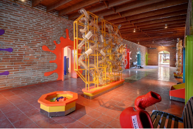
The north of Sinaloa has the first interactive museum aimed at promoting and fostering vocations in science and technology among children and young people. It is the Trapiche Museum, which offers 63 permanent exhibits in the city of Los Mochis.
Trapiche is the name of the old mills used in the sugar cane milling process, and because the city of Los Mochis grew up around a sugar mill, citizens, through a previous contest, decided to give that name to the museum .
The museum offers rooms such as Science, in which through 15 exhibits attendees interact with virtual reality and educational robotics.
In the Small area, children practice their motor skills and understanding in handling emotions. The Multithematic area complements the work of the school, becoming a space for experimentation for primary-level children.
The Connoisseurs area seeks to awaken in children and young people an interest in the study of exact sciences; while the Exterior area promotes contact with nature, and the Creators area encourages the creation of arts.
The 3D Room complements the contents exhibited in the museum and has 121 seats, which functions as a projection room for educational 3D films and a multipurpose room.
The museum offers 63 permanent exhibits, an open-air theater and the Trapiche Route, which consists of a train ride through much of the museum area.
The Technology and Robotics area is integrated into the Robotics Academy, where children develop technological knowledge and participate in summer workshops for the design and construction of robotics, introductory robotics and advanced robotics.
The Trapiche Museum participates in the RobotiX Faire, in which it obtained an outstanding participation in 2016, in Mexico City. Sinaloan children and adolescents obtained first and third place in international competitions.
http://www.cienciamx.com/index.php/sociedad/museos/17402-trapiche-museo-interactivo-sinaloa

Gringos in Los Mochis, Sinaloa
https://youtu.be/wUD3AeEYA8M
6. History
Los Mochis (from mochim, plural of mochic, Cahitan for "earth turtle" and used to refer to the flowers of Boerhavia coccinea) was founded in 1893 by a group of American utopian socialists who were adherents of Albert Kimsey Owen, an American civil engineer who built the first irrigation ditches in the valley. The colony, organized under the principles of utopian socialism, survived for 31 years. Albert K. Owen, the American civil engineer who came to do studies for the construction of a railway, was enchanted by Ohuira Bay and imagined the city of the future, where railways and shipping lines converged to ship throughout the world. Today, the port city of Topolobampo continues to be developed and may one day reach Owen's dream.
The city was founded by a businessman named Benjamin F. Johnston, who came to make a fortune in the cultivation of sugarcane. Benjamin F. Johnston arrived at Topolobampo attracted by Owen's city project. Johnston saw an opportunity to exploit resources such as sugar cane and with Edward Lycan, who had been linked to Zacarías Ochoa, owner of a Trapiche (raw sugar mill) named "El Águila", initiated the construction of a sugar mill. Ochoa died suddenly, and Johnston seized businesses that Lycan and Ochoa founded. "El Águila Sugar Refining Company" later became "United Sugar Company."
In 1898, Johnston laid the first stone of the sugar mill and drove the rapid growth of the city around it. The first harvest was welcomed in the year 1903.
Johnston was a very powerful and influential businessman, so powerful that he drew the street plans for Los Mochis — a modern city with wide and straight streets. It was not recognized as a city until 1903 along with Topolobampo. On 20 April 1903 a decree was founded by the mayor of Los Mochis, during the state government of Francisco Cañedo. In 1916, establishing the town of Ahome and since 1935 the municipal seat of the latter is in the city of Los Mochis. It is currently the commercial center of Valle del Fuerte and its radius of influence extends from the southern part of the neighboring state of Sonora and to the municipalities of El Fuerte, Sinaloa, Choix and Guasave in Sinaloa.
The economic development of the city began with the sugar industry, but in recent decades, its progress rests on the high-tech agriculture is practiced throughout the northwestern region of Mexico.
A group of enthusiastic people in la Villa de Ahome, under the name of "separatist," fought to create a municipality outside the hegemony of El Fuerte. It achieved its objectives until 5 January 1917 when the mayor came to El Fuerte to install a new city hall in which he presided Ramon C. López who had been appointed by the state governor Francisco Cañedo.
The municipality of Ahome was created by decree of the Local Legislature dated 20 December 1917, being governor of the state Gral. Ángel Flores, and was appointed head of the municipality of La Villa de Ahome.
In 1918 Florencio A. Valdés, was the first elected mayor.
The City Council Ahome preceded by Modesto G. Castro decided to make the move to the town of Los Mochis, justifying that this population had grown so much that already exceeded several times to La Villa de Ahome.
The City Council Ahome, in a decision dated 1 April 1935, allowed the change to the header, and the State Legislature passed it through another decree issued on May 10 next, which was published in the Official Journal of State the 30th day of the month.
The transfer took place without major problems right away and offices were installed in the house owned by Don Fco. Beltran, at the corner of Hidalgo and Zaragoza next to the local occupied by the former Sindicatura.
The old town of Ahome, to remain laggard in the process of the region, had been relegated to second place. Since then the city of Los Mochis, as the town of Ahome whole have had major changes in both economic and social policy have remained constant progress to the municipality.
7. Contact Information

City Mayor: Manuel Guillermo Chapman Moreno
Phone number: +52 (668) 816 4002
Facebook: https://www.facebook.com/BillyChapmanMoreno
Twitter: https://twitter.com/billychapmanmx
Website: https://www.ahome.gob.mx
Govt. Office Address: Degollado s/n, Centro, 81200, Los Mochis, Sin.
