Gómez Palacio, Durango 作者: 来源: 发布时间:2021-11-18
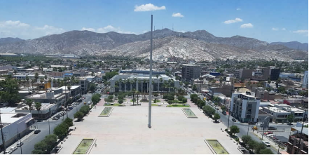
1.Population and Area
Pop: 342,286 (metro)
Area: 844,07 km2 (munip.)
Elev: 1135 masl
2. Natural geography
Nature and weather
Hydrography
The area includes the section within the limits of the municipality of Lerdo and the so-called "Boca de Calabazas", it does not have streams, only the torrential that descends from the Sierra del Sarnoso. The Tlahualilo canal came through the lands, since most of them are watered by the Sacramento canal, also called the "Relámpago"; These have water due to the gravity of the Lázaro Cárdenas and Francisco Zarco dams across the Nazas River, the first crops have been corn, beans, tomatoes, chili, melon, alfalfa, wheat, oats, cotton, etc.
Geology
The chemical sedimentary limestone rocks that make up the Sierra del Sarnoso, originated from the petrifrication of sediments deposited in a marine environment in the Mesozoic era, later they underwent changes that shaped it as we observe today, the limestone rocks were embedded, for a body that inherited the mineral from them, that they have constantly acted on the mountain systems, that have formed depressions and plains.
Flora and fauna
The Gomezpalatina flora is very varied where there is the Matorral, the lechuguilla, candelillas, sotol, mesquite, the governor and nopales.
In the fauna, the coyote, hare, rabbit, snake, prairie dogs, wild cats etc. stand out.
Köppen Classification: Tropical and Subtropical Desert Climate
This climate is dominated in all months by the subtropical anticyclone, or subtropical high, with its descending air, elevated inversions, and clear skies. Such an atmospheric environment inhibits precipitation. Most of Earth's tropical, true desert climates occur between 15° and 30° latitude. The most extreme arid areas also are far removed from sources of moisture-bearing winds in the interiors of continents and are best developed on the western sides of continents, where the subtropical anticyclone shows its most intense development. An exception to the general tendency for aridity to be associated with subsidence is in the Horn of Africa region, where the dryness of Somalia is caused more by the orientation of the landmass in relation to the atmospheric circulation. Both the high- and low-sun monsoonal winds blow parallel to the coast, so that moisture-laden maritime air can penetrate over land only infrequently.
The Köppen Climate Classification subtype for this climate is "Bwh". (Tropical and Subtropical Desert Climate).
The average temperature for the year in Gómez Palacio is 71.8°F (22.1°C). The warmest month, on average, is June with an average temperature of 82.9°F (28.3°C). The coolest month on average is January, with an average temperature of 57.0°F (13.9°C).
The highest recorded temperature in Gómez Palacio is 111.2°F (44°C), which was recorded in May. The lowest recorded temperature in Gómez Palacio is 15.8°F (-9°C), which was recorded in December.
The average amount of precipitation for the year in Gómez Palacio is 8.2" (208.3 mm). The month with the most precipitation on average is September with 1.6" (40.6 mm) of precipitation. The month with the least precipitation on average is February with an average of 0.1" (2.5 mm). In terms of liquid precipitation, there are an average of 33.6 days of rain, with the most rain occurring in August with 5.2 days of rain, and the least rain occurring in March with 0.7 days of rain.
http://www.weatherbase.com/weather/weather-summary.php3?s=985026&cityname=G%F3mez+Palacio%2C+Durango%2C+Mexico&units=
Getting there and around
Get there
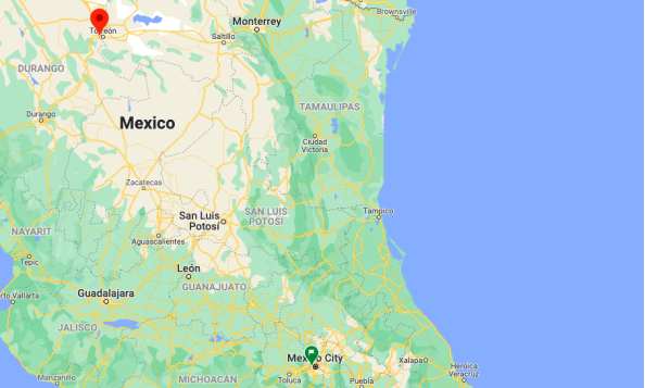
By plane – The cheapest way to get from Mexico City to Gómez Palacio is to fly which costs $850 - $2500 and takes 3h 11m, including the bus commute. The quickest flight from Mexico City Airport to Torreon Airport is the direct flight which takes 1h 40m.
By car – The driving distance between Mexico City to Gómez Palacio is 984 km. It takes approximately 10h 56m to drive from Mexico City to Gómez Palacio.
By bus – The cheapest way to get from Mexico City to Tecomán is to bus which costs $1000 - $1500 and takes 15h 51m.
https://www.rome2rio.com/s/Mexico-City/G%C3%B3mez-Palacio
Rideshare – Check out Blabla Car's carpooling service for rideshare options between Mexico City and the city you are visiting. A great option if you don't have a driver's license or want to avoid public transport.
Car Rental – To explore Mexico’s provincial towns and cities—including its beach locations and the scenery and attractions near them— consider renting a car for your visit. Having your own car will give you more flexibility than using public transport options and, in some cases, offer you access to places which are otherwise difficult to visit without the use of a car.
COVID19 – International entry into Mexico from United States
Allowed for: All visitors arriving by air. Mexico land borders are closed to non-essential travel
Restricted for: There are no current restrictions.
Get around
Local Buses – Local buses and mini-buses (combis or micros) are available locally for a fraction of the cost of a taxi around town. You need to speak Spanish to be able to ask for directions or ask the driver to tell you where to get off.
Taxis – Taxis in most of Mexico’s towns and cities are not metered, so agree your price before you get in. Taxi travel is very affordable in Mexico, in comparison to the USA, Canada and Europe, and so provides a viable means of public transportation in Mexico. Your hotel can arrange taxis for you; some post their rates on a board in the lobby; taxi hotel rates are usually higher than cabs you hail off the street. If you speak Spanish, you will have a distinct advantage and be able to negotiate a price with the driver.
Uber is expanding rapidly across Mexico and now offers services in cities across the country, including: Mexico City, Toluca, Cuernavaca, Puebla, Querétaro, León, Aguascalientes, San Luis Potosí, Guadalajara, Monterrey, Hermosillo, Tijuana, Mexicali, and Mérida. Uber has been adding Mexican cities to its network every year, check for availability when you arrive at your destination in Mexico.
Cabify and Didi are also developing and currently operate in cities including Mexico City, Toluca, Monterrey, Puebla, Querétaro and Tijuana. Check for availability in the city you are visiting.
These services offer people with smartphones a way to book a cab through a mobile app for a pre-agreed price. Fares are comparable with Sitio type cabs, and sometimes trade at a premium to this when local demand increases.
https://www.mexperience.com/transport/taxi-travel-in-mexico/#51
3. ECONOMY
GDP: 137,867 M MXN (2010, Torreón-Gómez Palacio metro area)
https://imco.org.mx/ciudades2010/ciudades/04_Lalaguna.html
4. Industry characteristics
Gómez Palacio's international sales in 2019 were US $ 191M, which decreased by 5.28% compared to the previous year. The products with the highest level of international sales in 2019 were Motor Vehicle Parts and Accessories (US $ 116M), Boxes, Sacks, Bags and other Paper Packaging (US $ 27.6M) and Trailers and Semi-trailers for Any Vehicle; the Other Non-Automobile Vehicles; its Parts (US $ 13M).
The main industrial sectors in Gómez Palacio (based on total gross production) in 2014 were Manufacturing Industries ($ 36.7M MX), Sectors Grouped by the Principle of Confidentiality ($ 3.8M MX), Wholesale Trade ($ 3.6M MX), Transportation , Post Office and Storage ($ 2.66M MX) and Retail Trade ($ 2.38M MX).
https://datamexico.org/es/profile/geo/gomez-palacio
Key project: two new industrial parks in Gómez Palacio
Entrepreneurs from the Lagunera region are interested in investing in a project for another industrial park that would be on land belonging to the ejido las Huertas in an area of 56 hectares, which will be about 800 meters from the Altozano housing complex.
While a third project that will be another industrial park and would be in front of the El Vergel ejido, on the road to Jiménez Chih. Investors want to start the projects in June, because they are short-term projects.
Regarding the investments that will be carried out in each of them, Mayor Leticia Herrera indicated that the amounts are not yet available, but that the figures are very important as well as that they will generate more sources of employment for this municipality.
https://www.elsoldedurango.com.mx/local/municipios/tres-nuevos-proyectos-de-inversion-para-gomez-palacio-3451993.html
5. Attractions
Mapimi (Biosphere Reserve)
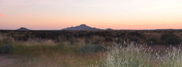
Mapimí is located in the Durango State in northern Mexico between the Neotropical and neartic biogeographical region, in the ‘Bolson de Mapimí’ 1,150 meters above the sea level. It contains three core areas in the ‘Sierra de la Campana’, the ‘laguna de las Palomas’, a salted lagoon, and a desert habitat called ‘Dunas de la Soledad’. It comprises fragile warm desert and semi-desert ecosystems (particularly Chihuahuan desert), and the rich, highly adapted but vulnerable plants, mainly xerophytic matorral, and animal species as the puma (Puma concolor), venado bura (Odocoileus hemionus), the grullas (Grus canadensis) and the ‘zorrita del desierto’ 'Vulpes macrotis' along with scrubs and desert grasslands. 72,600 inhabitants (1997) live in the reserve, mainly engaged in extensive cattle raising, salt exploitation and in agriculture.
Mapimi, located in the heart of the Biosphere Reserve Mapimí Baggins, is considered a magical town. At the foot of the Hill of Kufa and India, was founded in 1598 and its original name Mapeme means Cerro Piedra High or High. Its historic center is notable for its admirable architecture of the seventeenth and eighteenth centuries, overhanging the Postal Service, the Temple of the Lord of Mapimí, the Church of St. James and Casa del Cura de Dolores.
https://en.unesco.org/biosphere/lac/mapimi
https://www.zonaturistica.com/en/things-to-do/durango/gomez-palacio-ciudad-lerdo/mapimi-biosphere-reserve
Grutas El Rosario (Groves)
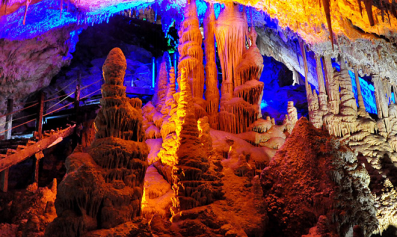
It is a true natural wonder within the reach of all tourists. From the history of the caves it is known that they were discovered not many years ago by the ejidatarios of the place. Inside there are rocks that grow thirteen millimeters a year due to the accumulation of calcium bicarbonate salts transported by water. They develop vertical, from top to bottom and from bottom to top; there are others that defy gravity, as they surface flat on a horizontal plane. The caves have a depth of several hundred meters, which implies a journey of two to three hours.
During the walk, you can see an infinity of gigantic figures inside, which have been baptized by tourists and guides with the name of the vulture, the monk, the organ, the lovers. It is certainly an extraordinary experience. Upon entering, it seems that one enters a fantasy world where the stones grow and come to life, but at a very slow pace.
Rosary caves are a real natural spectacle where you can appreciate different rock formations. For a long time you were abandoned, but now guided tours are offered. At the base of the cave is a natural spring that emerges from the rock, you can be explored with the help of the guide to a depth of 500 meters. In the place is a tourist service center that includes general facilities abroad, as well as stage lighting inside and a zip line of 450 meters to cross the grotto.
https://www.turimexico.com/estados-de-la-republica-mexicana/durango-mexico/grutas-del-rosario-durango
Ojuela Bridge
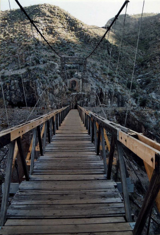
Ojuela was a small mining settlement located northwest of the nearest town Mapimí, 5 kilometres (3.1 mi) northwest. The settlement is now well known as a ghost town as a result of the ore being exhausted.
The origins of the mine can be traced to 1598 when it was discovered by a group of Spanish prospectors. After this discovery, the mineral potential was confirmed and the exploitation begun. Soon the foundations of the town were set. The town was located at the top of a mountain in close proximity to the mines main access. This was done in order to have the workers and other mining staff as close as possible to the operation. The town developed rapidly from a small settlement to a village with all the urban services of that age. This included a post office, Catholic church, several warehouses, general stores and saloons.
The Bridge
Built in 1892 over a 95-meter-deep ravine, this 318-meter-long and 1.80-meter-wide suspension bridge was used to transport mineral extraction from the San Rita mine to the town of Ojuela.
Its majestic presence in the middle of the arid landscape is the beginning of a journey through the tunnels of the Santa Rita mine that lead to a natural balcony where the beautiful desert tones of the Mapimí pocket can be appreciated, home to the enigmatic Zone of Silence, which Durango shared with Chihuahua and Coahuila.
Considered an engineering marvel, Today the rescue programs have arrived, and it seems that it is not too late; the historic bridge has been restored, the original wooden towers, which for 100 years supported its structure, were replaced by steel ones.
Various institutions develop scientific research projects and the inhabitants of the region participate in the protection and conservation of this architectural gem and the natural environment that surrounds it.
https://en.wikipedia.org/wiki/Ojuela
https://es.wikipedia.org/wiki/Ojuela
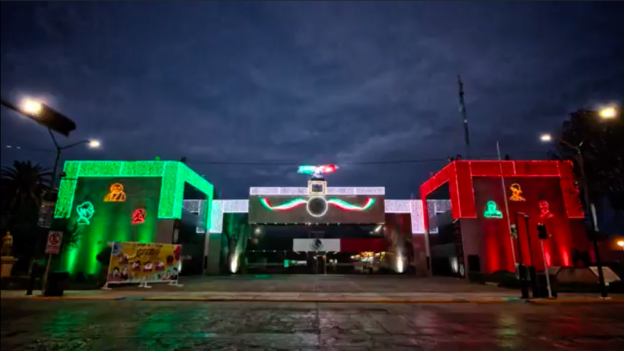
Zona Centro de Gómez Palacio
https://youtu.be/B5bF5gUbfWI
6. History
Old Hacienda of Santa Rosa
Possibly the old Santa Rosa farm was founded in 1844 by Don Juan Ignacio Jiménez, who in that year had rented the lagoon lands belonging to the state of Durango from Mr. Juan Nepomuceno Flores. Those lands that were the scene of the invasions of the barbarian Indians from the north, as Jerónimo's Comanches and Apaches were called; where years later the fights took place between the mercenary bands of the lords of the land who fought for control of the waters of the Nazas River. It was said that Don Santiago Lavín Cuadra built the dam and the aqueduct of Santa Rosa --Canal de La Línea-- to collect more water, thus having serious difficulties with the ranchers of the part of Coahuila, finally the matter was settled with the intervention of Sariñana and Vallarta lawyers.
Also in Santa Rosa, already in ruins, the revolutionaries of 1910 sometimes met to hold their secret meetings and there they buried their weapons in the days of the conspiracy. On the night of November 20 of that same year, about 40 men rose up in arms against the Porfirian government from its rubble. Still in the twenties, the ruins of the houses of the old hacienda were still standing, the remains of the walls eaten away by the passage of time were painted with red oil that gave it the appearance of a faded red.- A rough plaque A mixture placed on the outside of the wall that possibly belonged to the big house, vaguely indicated the date of the permanence of President Juárez and his companions. The adobe walls of Santa Rosa emerged amid huizaches, mesquite trees, and wild plants that grew in the already stony terrain, where all kinds of vermin lived. It was the paradise of the boys hunting lizards, squirrels, chameleons, etc.
Gómez Palacio Foundation
In the year 1883, in a place called Calera in the state of Zacatecas, the ends of the railroads were joined that in the north and south directions, the American company of the Mexican Central Railroad had been building for some time. At the end of the railway network, Mexico City was connected to the northern border of the country, precisely with the town of Paso del Norte, today Ciudad Juárez. The passenger trains that made regular service from time to time stopped at the small way station known as Lerdo or Santa Rosa, where travelers from the Ciudad Lerdo and surrounding estates arrived and departed. The modest railroad stop gave rise to the founding of Gómez Palacio. The following year, in 1884, in front of the whereabouts of the trains the small wooden telegrapher's booth was raised and almost at the same time in the middle of the plain where only the governor, the huizache and mesquite grew, a patched tent appeared where it was installed The first inhabitant of those places, which was Emma Blanco, later the owner of those lands, Alan Blanco gave him a piece of land where he built an adobe house, probably where the Huizache inn was later, because the old people said that there the first farm had been built. The aforementioned inn was on the current Allende street. Emma later received the appointment of head of the barracks, when the number of inhabitants had already increased. Later, a Spaniard named Rosario Valenzuela, raised the second house, where he established the first trade taking advantage of the passage of the travelers; shortly afterwards the estates of Hugo Franck and Federico Ritter were built, at which time the first street was opened, which was later Hidalgo Avenue and which is now Independencia Street. Little by little, industrious men arrived who were clearing the plain of bushes, establishing their homes.
First transport services
The mulitas trams began to circulate in December 1898, by then the public lighting plant that had been put into service on April 2 of the same year was already working. For this purpose, a company had been formed with the following board of directors: - president Juan Brittingham, and secretary Miguel Torres and treasurer Carlos Michaud. In front of the Unión hotel on the corner of Ampuero -Francisco I. Madero and Cerviago -Centenario streets, the mulitas trams had their terminal, from there they left for Lerdo on one side of the royal road and reached the main square ; Those who went to Torreón after crossing cliffs, sandbanks and the dry ford of the Nazas River, ended their journey in front of the old railway station in the city of Coahuila. The trams changed animals in each terminal and they said that one of the best known drivers and that he was one of the last to serve, was a man called Sósteres who was always dressed as a charro and sounded a horn announcing the passage of the vehicle through the streets. cobbled or dusty streets of the three cities. The trams provided passenger and cargo service, and in 1900 they transported 1,222,000 passengers and handled 18,600 tons of cargo, bringing their income in that year to more than 100,000 pesos.
Mexican Revolution
On the night of November 20, 1910, a group of 40 dissatisfied men took up arms against the authorities of the Porfirian regime. The group of rebels had been organizing for months and attending secret meetings in a small office currently located on the streets of Mártires and Avenida Hidalgo. This group obeyed the invitation made by Francisco I. Madero, who invited the people of Mexico to take up arms on November 20. That night the rebels stormed the city bank, assassinated the main ranchers and released the prisoners from jail inviting them to be part of their cause. This event gave rise to the Mexican Revolution as well as others that happened in the Mexican territory.
In 1914 the capture of Gómez Palacio took place, which began when the loyal revolutionaries under the orders of Pancho Villa attacked the unsuspecting forces of the federal army that were located at the top of the Cerro de la Pila. This military victory would serve to control the lagoon of the state of Durango and later continue to take the city of Torreón.
Gómez Palacio (1917-1975)
During the withdrawal of the Villista troops, the city little by little took on the prosperity and confidence that characterized this area during the mandate of Porfirio Díaz, but the prosperity would not last long since the Mexican nation along with most of the western nations of the world would be affected by the Crisis of 1929.
Prosperity arrived once the Second World War ended, Gómez Palacio enjoyed a period of social prosperity, so much so that the municipality could afford to place public lighting in its main avenues, as it was on August 10, 1952 inaugurates public lighting on the Torreón-Lerdo highway (now Miguel Alemán Boulevard).
In 1960, Lic. González de la Vega, then Governor of the State of Durango, created a Municipal Planning Council to immediately carry out the necessary studies for the layout of an industrial park. Once the land was located, the works began, opening paved streets with all services. Gradually, the results of the creation of the industrial zone were seen, and thus in 1972 about 55 million pesos were invested, lent by banks and finance companies for this purpose, the investment made that year being higher than that made in any other city in the country.
On September 15, 1968, the city suffered a catastrophic flood as the flood of the Nazas River increased dramatically. This fact caused destruction in the ejidos and roads that were located on the banks of the river, the majority of the population of Gómez Palacio was evacuated because the river managed to penetrate the city, this being one of the few occasions that the river manage to overflow.
7.Contact Information.

City Mayor: Alma Marina Vitela Rodríguez
Phone number: +52 (871) 175 1000
Facebook: https://www.facebook.com/AlmaMarinaVitela
Twitter: https://twitter.com/MarinaVitelaGP
Website: https://www.gomezpalacio.gob.mx
E-mail: marina.vitela@gomezpalacio.gob.mx
Govt. Office Address: Av. Fco. I Madero 400, Col. Centro, Gómez Palacio, Dgo.
