Tecomán, Colima 作者: 来源: 发布时间:2021-11-18
1.Population and Area
Pop: 141,421 (metro)
Area: 808 km2 (munip.)
Elev: 33 masl
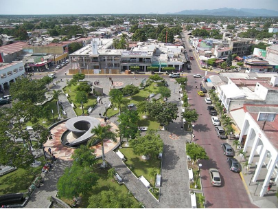
2. Natural geography
Nature and weather
Land use
The soils, for the most part, are of alluvial origin although in a different way of formation, since there are those that were constituted by the floods of the Armería and Coahuayana rivers, by the sand deposits of the ocean and those that were interspersed with sediments of maritime origin. Its main use is agricultural. There are limestone-shale and pozzolan minerals.
Flora and fauna
Rural vegetation: the one that predominates in the mountains is formed by xolocoáhuitl, habillo, mojo, guásima, tepemezquite, asmol, llorasangre, timúchil, coliguana, granjén, otate, picus, parotas, etc.
Urban vegetation: the part of the valley was reforested with plantations of palm trees, fruit trees, lemon, mangoes, almond trees and other crops.
The fauna is made up of these species: coyote, wild boar, badger, squirrel, iguana, crocodiles, river fish, alligators in estuaries and lagoons; birds such as the güilota, the chachalaca, among others.
Köppen Classification: Tropical Savanna Climate
Tropical savanna climates have monthly mean temperature above 18°C (64°F) in every month of the year and typically a pronounced dry season, with the driest month having precipitation less than 60mm (2.36 in) of precipitation. In essence, a tropical savanna climate tends to either see less rainfall than a tropical monsoon climate or have more pronounced dry seasons than a tropical monsoon climate. Tropical savanna climates are most commonly found in Africa, Asia and South America. The climate is also prevalent in sections of Central America, northern Australia and North America, specifically in sections of Mexico and the state of Florida in the United States.
The Köppen Climate Classification subtype for this climate is "Aw". (Tropical Savanna Climate).
The average temperature for the year in Tecomán is 80.1°F (26.7°C). The warmest month, on average, is July with an average temperature of 83.8°F (28.8°C). The coolest month on average is February, with an average temperature of 75.6°F (24.2°C).
The highest recorded temperature in Tecomán is 105.8°F (41°C), which was recorded in May. The lowest recorded temperature in Tecomán is 34.7°F (1.5°C), which was recorded in February.
The average amount of precipitation for the year in Tecomán is 30.6" (777.2 mm). The month with the most precipitation on average is September with 7.2" (182.9 mm) of precipitation. The month with the least precipitation on average is April with an average of 0.1" (2.5 mm). In terms of liquid precipitation, there are an average of 49.5 days of rain, with the most rain occurring in August with 11.6 days of rain, and the least rain occurring in April with 0.1 days of rain.
http://www.weatherbase.com/weather/weather-summary.php3?s=986058&cityname=Tecom%E1n%2C+Colima%2C+Mexico&units=
Getting there and around
Get there
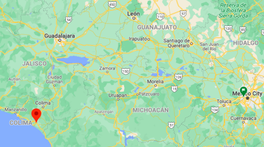
By plane – The quickest flight from Mexico City Airport to Colima Airport is the direct flight which takes 1h 20m. From there, you can get to Tecoman by road, which is quick and easy. In Colima's state capital, there are two bus stations which have direct service to Tecoman. It's all downhill toward Tecoman, coming out of the mountains in which Colima is situated and it takes about one to two hours to arrive at the Tecoman central bus station. Buses run throughout the day, pretty much constantly and there's also some night service.
By car – The distance between Mexico City and Tecomán is 502 km. The road distance is 755.5 km. It takes approximately 8h 8m to drive from Mexico City to Tecomán.
By bus – The cheapest way to get from Mexico City to Tecomán is to bus which costs $1000 - $1500. There are services departing from México Poniente and arriving at Tecomán via Colima. The journey, including transfers, takes approximately 11h 27m.
https://www.rome2rio.com/s/Mexico-City/Tecom%C3%A1n
Rideshare – Check out Blabla Car's carpooling service for rideshare options between Mexico City and the city you are visiting. A great option if you don't have a driver's license or want to avoid public transport.
Car Rental – To explore Mexico’s provincial towns and cities—including its beach locations and the scenery and attractions near them— consider renting a car for your visit. Having your own car will give you more flexibility than using public transport options and, in some cases, offer you access to places which are otherwise difficult to visit without the use of a car.
COVID19 – International entry into Mexico from United States
Allowed for: All visitors arriving by air. Mexico land borders are closed to non-essential travel
Restricted for: There are no current restrictions.
Get around
Local Buses – Local buses and mini-buses (combis or micros) are available locally for a fraction of the cost of a taxi around town. You need to speak Spanish to be able to ask for directions or ask the driver to tell you where to get off.
Taxis – Taxis in most of Mexico’s towns and cities are not metered, so agree your price before you get in. Taxi travel is very affordable in Mexico, in comparison to the USA, Canada and Europe, and so provides a viable means of public transportation in Mexico. Your hotel can arrange taxis for you; some post their rates on a board in the lobby; taxi hotel rates are usually higher than cabs you hail off the street. If you speak Spanish, you will have a distinct advantage and be able to negotiate a price with the driver.
Uber is expanding rapidly across Mexico and now offers services in cities across the country, including: Mexico City, Toluca, Cuernavaca, Puebla, Querétaro, León, Aguascalientes, San Luis Potosí, Guadalajara, Monterrey, Hermosillo, Tijuana, Mexicali, and Mérida. Uber has been adding Mexican cities to its network every year, check for availability when you arrive at your destination in Mexico.
Cabify and Didi are also developing and currently operate in cities including Mexico City, Toluca, Monterrey, Puebla, Querétaro and Tijuana. Check for availability in the city you are visiting.
These services offer people with smartphones a way to book a cab through a mobile app for a pre-agreed price. Fares are comparable with Sitio type cabs, and sometimes trade at a premium to this when local demand increases.
https://www.mexperience.com/transport/taxi-travel-in-mexico/#51
3. ECONOMY
GDP: 10,707 M MXN (2010, Tecomán-Armería metro area)
https://imco.org.mx/ciudades2010/ciudades/09_Tecoman.html
4. Industry characteristics
Tecomán there are various companies that have settled in the municipality and contribute with jobs. The industrial, commercial and services sector is one of the strongest in this municipality with the participation of large companies such as Coca-Cola, Danisco, Holcim Ltd-Apasco, Bodega Aurrerá, Mercado Soriana, Grupo Lala, Modelo, PepsiCo, Bimbo, among others.
Due to the characteristics of the Tecomán soil and the climate, there is a significant proportion of agricultural land use.
Primary sector: agriculture, livestock, forestry and fishing.
Secondary sector (Industry): manufacturing, building, electricity and water.
Tertiary sector (Service): commerce, transport and comunication, tourism, public administration, and others.
Tecomán's international sales in 2019 were US $ 64.3M, which grew 7.96% compared to the previous year. The products with the highest level of international sales in 2019 were fresh or dried citrus fruits (US $ 32.5M), essential oils (concentrates or not), including "concrete" or "absolute"; resinoids; extraction oleoresins; concentrated solutions of essential oils in dats, fixed oils, waxes or similar matters, obtained by chilling or maceration; residual terpenic by-products of essential oils deterpenation; aqueous aromatic distillates and aqueous solutions of essential oils (US $ 25.5M), and figs, pineapples, avocados, guava, and mangos, fresh or dried (US $ 3.42M).
http://www.municipios.mx/colima/tecoman
https://datamexico.org/es/profile/geo/tecoman
Key project: New IMSS hospital in Tecomán
Elías Lozano Ochoa, mayor of Tecomán, and the IMSS delegate in the state, Rafael Briceño Alcaraz, announced the construction of a new general hospital that will have 90 beds, consultation service, as well as specialties.
The equipped project contemplates an investment of 832 million pesos in a 3-hectare land donated by the commune and which is located in the Legal Status neighborhood, on the ranch known as El Edén near the Fernando Moreno bypass.
There is no start date yet because the municipal government awaits the authorization of resources from the Tax Administration Service (SAT), however, construction is expected to begin this year.
https://elcomentario.ucol.mx/anuncian-construccion-de-nuevo-hospital-del-imss-en-tecoman
5. Attractions
Tecomán beaches
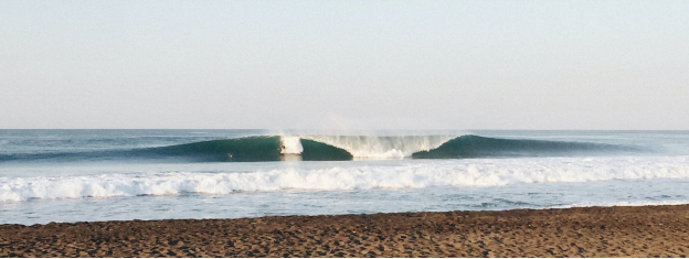
It is always a nice idea to visit the Tecoman beaches. Prepare yourself to enjoy the fine sand and sunbathing. Take advantage of the weather that can range from warm semi dry to warm subtropical. 12 kilometers from the city you will find Boca de Pascuales beach, this is an open sea beach with deep waters, the perfect beach if you like adventure. You can practice surfing here.
El Real beach is located 10 kilometers south from the city, and just 5 minutes distance by car. This is also an open sea beach, though the waves are moderate and allows you to practise surfing as well.
In Tecuanillo town, just 13 kilometers from Tecoman, the Tecuanillo beach is located. An ideal beach for swimming and practising surfing in its strong waves. If you walk through its riverbank you can get to the Tecuanillo river, a zone that is surrounded by mangroves and birds. It is allowed to camp here.
https://www.visitmexico.com/en/colima/tecoman/beaches
Archaeological Museum of Caxitlán
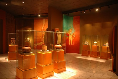
A tour through the Archaeological Museum of Caxitlán will allow you to understand the history of the region through a display of more than 200 pieces coming from the Pre-hispanic culture. Tombs and funerary offering stands out, as well as some pieces and historic objects closely linked to the city.
The museum has 4 exhibition halls: Los chamanes room shows a general geographic scenery from the zone; at the Capacha hall you can learn about Colima and the north coast of Michoacan; in the Good and Bad room you will find the gifts of Heaven and Earth, the origin of God and the chain of life; finally, in the Tumba de tiro hall you can learn about the myths, rituals and the eternal enclosure.
There’s another hall in the museum that allows you to learn about the geography of this state and see the first archaeological evidence of myths and rites in the region.
https://www.visitmexico.com/en/colima/tecoman/archaeological-museum-of-caxitlan
Tecomán Lagoons
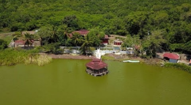
Come and visit the different Lagoons in Tecoman. You will have the best adventure of your life visiting the natural water deposits of the region and enjoying its beautiful landscapes.
The Alcuzahue lagoon is located 8 kilometers south from the city. This is the place in which the ecotourism lovers gather to take advantage of nature’s gifts and have a day full of outdoor activities like biking, practising sport fishing or just enjoying the contrast of the jungle and the lagoon through a boat trip.
This lagoon is the scenario for different women's volleyball tournaments. To get here you need to take the Boca de Apiza highway and then La Cuarta, and from here follow your way to the lagoon.
Amela lagoon is located 20 kilometers from the center of Tecoman. This is a deep and large lagoon and its natural surroundings allows practising different eco-friendly activities.
If you take a boat trip you will be able to admire the big hills covered with vegetation and you can even try fishing.
https://www.visitmexico.com/en/colima/tecoman/lagoons
Esto es TECOMAN, COLIMA
https://youtu.be/RE2MiM9a8B8
6. History
First traces
When the Spaniards arrived, the territory or kingdom of Colliman was inhabited by the indigenous group of the Tecos, whose headquarters were the town of Caxitlán, in the Tecomán valley; they were the strongest group in the region in which the hueytlatoani Colimotl (dominant chief) lived. It was precisely in Caxitlán where the conquerors had their first settlement, of which a record remains in the Royal Certificate dated June 26, 1530, through which the Queen of Spain granted arms to Jerónimo López and which to the letter says: " The Spaniards had a great battle encounter with the natives who were withdrawn and strengthened in the said population of Tucumán (Tecomán), in which said term a Spanish village was founded, in which you resided ”.
The original village was located in a place located five kilometers north of the current Tecomán railway station, where one of the few vestiges of what was Caxitlán remains, the centenary bare walls of the Caxitlán mesón. The Tecomán Valley has historically been considered the most important region of the Kingdom of Colima.
Conquest
After the taking of Tenochtitlan by the Spanish and having subordinated the Purépechas, the emissary of Hernán Cortés, Francisco Montaño, who had ventured to Tzintzuntzan, collected a report from the Michoacanos who said that the west of the Caltzontzin empire was a place dominated by the King of Colima. Hernán Cortés, thought of conquering Colima, but Juan Rodríguez de Villafuerte precipitated his plans by disobeying his orders and being the first to explore the area, upon arrival in Trojes he was defeated in an ambush by King Colimán. Shortly after, he decided to entrust the company to Juan Álvarez Chico. He set out with a small army on the road to Toluca, towards the Michoacan coast.
When crossing with theirs, a gorge in Colima the Colima people attacked by surprise, dying in the battle Juan Álvarez Chico along with other Spaniards who were defeated in the battle. After this defeat the punitive expedition was entrusted to Cristóbal de Olid who in 1522 was sent to conquer Michoacán, a province that he conquered in the name of Hernán Cortés, and since he was on the road, he was sent to assist Juan Álvarez Chico in the Colima province, where he was also defeated by King Colimán at Paso de Alima and / or Palenque de Tecomán. Cortés entrusts the next expedition to Gonzalo de Sandoval, who defeats the Colima in Colima, where King Colimán surrendered.
Ancient towns
Caxitlán 1523-1862: Place where the primitive Villa de Colima and the first town hall of western New Spain were founded by the conqueror Gonzalo de Sandoval, on July 25, 1523, located in the Tecomán Valley. When the Spaniards arrived, the area was inhabited by the ethnic group called Tecos, whose headquarters were in the town of Caxitlán, in a place located five kilometers north of the current Tecomán railway station. The Tecomán Valley has historically been considered the most important region of the Kingdom of Colima.
The decline of the town of Caxitlan, the careless pastoral administrations, the change of diocesan affiliation, the transfer of the parish see, the decrease in the assets of the brotherhood, ...., are factors that combine in the extinction of the town. In about ten years the cult of "the Virgen de la Candelaria de Caxitlan seems on the verge of extinction."
At the end of February 1810, Fr. Rasura wrote: "The Yglesia de Cagitlan has been burned for nine years when it was a priest ..." Inaccurate date but which, according to the usual way of counting then, indicates a date before February 1801.
At the beginning of October 1800, the indigenous people of Santiago Tecomán were legally already curate en encomienda and, a few days later, the fire of the until then legally "parochial" temple of Caxitlan must have occurred.
The fire in Caxitlan destroyed the temple and a large number of houses, so the emigration to Valenzuela increased, becoming in the middle of the 19th century, this last population, the most important in the Valley.
Valenzuela 1778-1885: It was an important town of 342 inhabitants, most of the settlers of European origin, it was located 6 km north of Tecomán and it was reached by a road that was the extension of Calle Real, which is the current Avenida Independencia. It was considered the most representative nucleus of the miscegenation of the Tecomán valley at that time. They built a church, built a wide square and prepared a pantheon, which came to be widely used, as 120 people were buried there during a measles epidemic in 1826.
After the fire and destruction of Caxitlán, in 1800, Valenzuela appeared in the statistics of the Santiago de Tecomán Parish Archives, gaining a higher profile in all orders, as the short years of its existence passed.
There is evidence that in the middle of the last century it reached greater economic and demographic importance than Tecomán. Unlike Tecomán, which until the end of the last century was populated by a majority of Indians, in Valenzuela the creoles and mestizos dominated. Its fertile lands came to give it an opulence that Tecomán did not enjoy at the same time, until finally around 1885, it depopulated and disappeared.
This town was like a meteor that fleetingly crossed the historical sky of Tecomán with blinding light and disappeared. It has not been possible to unravel the mystery that represented his birth and disappearance in the utter valley.
Suburb
After consummating the conquest of Mexico (1520), on July 25, 1523, the day of the feast of the Apostle Santiago, the Spanish conqueror Gonzalo de Sandoval founded in Caxitlán (Municipality of Tecomán) the primitive Villa de Colima and the first Town Hall in western New Spain.
Same year that Tecomán was founded (two leagues from Caxitlán). The main factor was the convenience of the Spaniards to be able to control the natives, forcing them to concentrate and found a town, which they called "Santiago de Tecomán". The name of Santiago was taken from the apostle that they venerated as patron of the hospital that dates from approximately 1550. Tecomán was born as an autochthonous town and it continued to be so and retaining the name of Santiago de Tecomán until the end of the last century.
The independence
In 1812 Captains Pedro and Manuel Regalado, at the head of their guerrillas, took the towns of Tecomán and Caxitlán, having attacked the important salt production center of El Real de San Pantaleón.
On December 29, 1826, Father Alcaraz, in the company of the mayors of Caxitlán, recognized, counted and branded the assets belonging to the Brotherhood.
By 1834, the interim priest of Santiago Tecomán, Celso García de Alba, finished raising and signing a census of the entire Tecomense parish jurisdiction, which showed a total of 2,115 inhabitants.
7.Contact Information

City Mayor: Elías Antonio Lozano Ochoa
Phone number: +52 (313) 322 9470, ext. 2001
Facebook: https://www.facebook.com/El%C3%ADas-Lozano-103469961393281
Website: https://www.tecoman.gob.mx
E-mail: presidencia@tecoman.gob.mx
Govt. Office Address: Medellín 280, Col. Centro, Tecomán, Colima, C.P. 28100
