Mexicali, Baja California 作者: 来源: 发布时间:2021-11-18
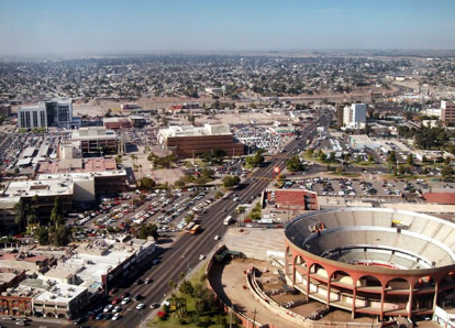
1.Population and Area
Pop: 1,032,686 (metro)
Area: 113.7 km2 (city)
Elev: 8 masl
2. Natural geography
Nature and weather
The Mexicali Valley is one of the largest and most fertile valleys in Mexico. Over fifty different crops are grown in the valley, which is similar in production to the Imperial Valley. National and international industries have invested in Mexicali and surrounding cities to take advantage of its tax-free status given to industry. The Mexicali Valley is a primary source of water for the region, which is the largest irrigation district in Mexico.
Despite its arid desert location, Mexicali is watered through a system of aquifers in the valley. Under a 1944 water treaty, the city is "...guaranteed an annual quantity of 1,500,000 acre feet (1.9 km3) to be delivered..." from the Colorado River. However, a proposed concrete lining in the United States on the All-American Canal would cut off billions of leaked gallons of water, which is used to irrigate onions, alfalfa, asparagus, squash and other crops in Mexicali.
The nearby Cerro Prieto volcano is adjacent to the Cerro Prieto Geothermal Power Station, which creates high volumes of pollutants, among them, mercury. As of 2014, the government are creating a zone of exclusion, due to the alarming amount of pollutants and contamination that has permeated throughout miles around the geothermal plant of Cerro Prieto.
The coastlines of the municipality are only by the Gulf of California with an approximate length of 210 km. In addition, the islands located in this Gulf, which cover approximately 11,000 ha, correspond to its jurisdiction.
These islands are: Montague, Gore, Encantada, San Luis, Ángel de la Guarda, Pond, Partida, Rasa, Salsipuedes and San Lorenzo.
Flora and fauna
In the aciculifolio forest there are Jeffrey pine, ponderosa pine, sugar pine, cedar and strawberry tree. The fauna of the municipality of Mexicali is represented by a variety of species adapted to different ecosystems, such as large marine, desert and forest areas.
http://www.inafed.gob.mx/work/enciclopedia/EMM02bajacalifornia/municipios/02002a.html
Köppen Classification: Tropical and Subtropical Desert Climate
This climate is dominated in all months by the subtropical anticyclon, or subtropical high, with its descending air, elevated inversions, and clear skies. Such an atmospheric environment inhibits precipitation. Most of Earth's tropical, true desert climates occur between 15° and 30° latitude. The most extreme arid areas also are far removed from sources of moisture-bearing winds in the interiors of continents and are best developed on the western sides of continents, where the subtropical anticyclone shows its most intense development. An exception to the general tendency for aridity to be associated with subsidence is in the Horn of Africa region, where the dryness of Somalia is caused more by the orientation of the landmass in relation to the atmospheric circulation. Both the high- and low-sun monsoonal winds blow parallel to the coast, so that moisture-laden maritime air can penetrate over land only infrequently.
The Köppen Climate Classification subtype for this climate is "Bwh". (Tropical and Subtropical Desert Climate).
The average temperature for the year in Mexicali is 58.0°F (14.4°C). The warmest month, on average, is July with an average temperature of 77.0°F (25°C). The coolest month on average is January, with an average temperature of 42.0°F (5.6°C).
The highest recorded temperature in Mexicali is 120.0°F (48.9°C), which was recorded in May. The lowest recorded temperature in Mexicali is 22.0°F (-5.6°C), which was recorded in January.
The average amount of precipitation for the year in Mexicali is 2.9" (73.7 mm). The month with the most precipitation on average is August with 0.5" (12.7 mm) of precipitation. The month with the least precipitation on average is May with an average of 0.0" (0 mm). In terms of liquid precipitation, there are an average of 12.7 days of rain, with the most rain occurring in September with 2.2 days of rain, and the least rain occurring in June with 0.0 days of rain.
http://www.weatherbase.com/weather/weather-summary.php3?s=150067&cityname=Mexicali%2C+Baja+California%2C+Mexico&units=
Getting there and around
Get there
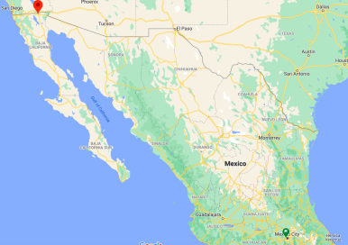
By plane – Mexicali's General Rodolfo Sánchez Taboada International Airport (IATA: MXL), is located 20 km east of the city and offers services to all types of flights, private and commercial. There are daily flights out of the Airport to other major cities in México.
The following airlines serve Mexicali: Aeromexico, Aeromexico Connect goes to Guadalajara & Mexico City. 'Connect' also goes to/from Cualican and Monterey. To/from Tijuana by bus operated by EcoBaja Tours and to/from Los Angeles on a bus operated by Intercalifornias.
Volaris: Mexico City & Guadalajara. They offer flights to additional cities from Tijuana and may offer better rates there.
There are more flights with additional airlines in Tijuana (TIJ) from other cities within Mexico than to Mexicali. Therefore, it may be more economical to fly to Tijuana and then taking the bus over to Mexicali without crossing into the U.S. There are direct buses with ABC (Autotransportes de la Baja California) and Grupo Estrella Blanca from the Tijuana airport to Mexicali.
From within the U.S. the nearest airport is Imperial County Airport (IPL) located in Imperial, CA. The airport is served by daily flights from LAX and Yuma, AZ and is a twenty-minute drive to the Calexico-Mexicali border crossing. The closest major airport is San Diego (SAN). From there one can take SDMTS #992 bus to downtown San Diego and transfer to Greyhound Lines to Calexico, CA and walk across the border into Mexicali or transfer to the SDMTS 'Blue Line' Trolley, from downtown San Ysidro to San Ysidro and walk into Tijuana and take the Grupo Estrella or ABC bus over to Mexicali along the Mexican side of the border.
By car – Mexicali is accessible from the United States through Calexico on Highway 111 (from El Centro and points north) and Highway 98 East (Yuma) and West (San Diego) via I-8 or as of 2011 you can cross by car through the East Port of Entry by going through Calexico on the SR 7 and for frequent crossers you can go through by the Ready Lane which is more rapid to cross through
Either park at the border and continue on foot or you drive into Mexico. Driving from the US to Mexico usually requires no stopping. Driving across the border from Mexico to the US may involve a long wait, especially during evening rush hour or on holiday weekends. Mexican insurance is required, which should be bought before your trip. Mexicali has two border crossings, Mexicali East (Newer) and Mexicali West (Traditional), both of which have a SENTRI lane.
Mexicali is the northern terminus for Mexican Highway 5 to San Felipe.
Mexicali can also be reached from Tijuana and Tecate on Mex-2. Though much of this highway is a toll road (the "Libramiento" aka Autopista), it is more scenic but will take longer than I-8 and is considered more hazardous, especially the "Rumorosa Grade".
By bus – The main bus station (Central de Autobuses) is 4km south of Zona Centro (downtown) off of Hwy 5 (Blvd Adolfo Lopez Mateos/Careterra Mexicali-San Felipe) at Calzada Independencia 1244, Col. Centro Civico CP21000 (Calzada Independencia & A. Lopez Mateos). The main bus station can be reached by a bus traveling along Calzada Independencia or by taxi from the city centre. From here there are direct coaches to most major cities in Mexico. The following bus companies operate buses to/from the central bus station. (Note: The 800 toll free numbers are for calling from within Mexico unless stated otherwise. Other numbers are regular or local numbers. From outside Mexico you will have to call the regular numbers.
By foot – Many people drive to the border, park on the US side, and walk across. There are many lots available for this. While there are many taxis waiting to take you across, it's only about a five-minute walk; follow the signs across.
https://wikitravel.org/en/Mexicali
Riseshare – Check out Blabla Car's carpooling service for rideshare options between Mexico City and Salamanca. A great option if you don't have a driver's license or want to avoid public transport.
Car Rental – To explore Mexico’s provincial towns and cities—including its beach locations and the scenery and attractions near them— consider renting a car for your visit. Having your own car will give you more flexibility than using public transport options and, in some cases, offer you access to places which are otherwise difficult to visit without the use of a car.
COVID19 – International entry into Mexico from United States
Allowed for: All visitors arriving by air. Mexico land borders are closed to non-essential travel
Restricted for: There are no current restrictions.
Get around
Local Buses – Local buses and mini-buses (combis or micros) are available locally for a fraction of the cost of a taxi around town. You need to speak Spanish to be able to ask for directions or ask the driver to tell you where to get off.
Taxis – Taxis in most of Mexico’s towns and cities are not metered, so agree your price before you get in. Taxi travel is very affordable in Mexico, in comparison to the USA, Canada and Europe, and so provides a viable means of public transportation in Mexico. Your hotel can arrange taxis for you; some post their rates on a board in the lobby; taxi hotel rates are usually higher than cabs you hail off the street. If you speak Spanish, you will have a distinct advantage and be able to negotiate a price with the driver.
Uber is expanding rapidly across Mexico and now offers services in cities across the country, including: Mexico City, Toluca, Cuernavaca, Puebla, Querétaro, León, Aguascalientes, San Luis Potosí, Guadalajara, Monterrey, Hermosillo, Tijuana, Mexicali, and Mérida. Uber has been adding Mexican cities to its network every year, check for availability when you arrive at your destination in Mexico.
Cabify and Didi are also developing and currently operate in cities including Mexico City, Toluca, Monterrey, Puebla, Querétaro and Tijuana. Check for availability in the city you are visiting.
These services offer people with smartphones a way to book a cab through a mobile app for a pre-agreed price. Fares are comparable with Sitio type cabs, and sometimes trade at a premium to this when local demand increases.
https://www.mexperience.com/transport/taxi-travel-in-mexico/#51
3. GDP
GDP: 134,502 M MXN (2010)
https://imco.org.mx/ciudades2010/ciudades/03_Mexicali.html
4. Industry characteristics
In its beginnings Mexicali was an important center for cotton production for export, until synthetic fabrics reduced the worldwide demand for the fiber. Currently, horticulture is the most successful agricultural activity with scallion (green onion), and asparagus being among the most important crops. Cotton and wheat are still grown, but low government price guarantees and subsidies make wheat farmer protests an annual event. There is an annual agri-business fair, which if unfunded by the government, would have been dead a decade ago, named AGROBAJA, Agrobaja in March of every year, drawing people by the thousands, from all over Mexico and before the crisis, from the United States.
The current prospects for economic growth in Mexicali rely on in-bond and assembly plants (maquiladoras), which come due to low wages and loose worker right laws, include companies like, Selther, Daewoo Electronics, Mitsubishi, Honeywell, Paccar, Vitro, Skyworks Solutions, CareFusion, Bosch, Price Pfister, Gulfstream, United Technologies Corporation, Kenworth, Kwikset and Rockwell Collins. Mexicali is also home to many food processing plants such as Nestlé, Jumex, Bimbo, Coca-Cola, Kellogg's, and Sabritas. A new Corona Beer brewery is under construction as of June 2019. In December 2018 there were 180 in all, employing 70,000 people.
Mexicali also relies on tourism as a medium to generate revenue, and visitors cross by foot or by car from Calexico, United States, every day. Tourists are mainly attracted to local taco stands, restaurants, pharmacies, bars and dance clubs. Near the border, in walking distance, there are many shops and stalls selling Mexican curios and souvenirs. Arizona and Nevada residents look for medical and dental services in Mexicali, since they tend to be less expensive than in the United States. Pharmacies sell some drugs without a prescription and at much lower cost than in the US, but some medications still require a doctor's prescription, although several accessible doctor offices are located near the border as well.
5. Attractions
Cuervitos Dunes
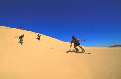
Traveling approximately 10 minutes on the highway to Mexicali, there is a sea of golden sand dunes, considered the highest in the state of Baja California: Cuervitos Dunes, which has catapulted the destination as one of the best for sandboarding.
The sport consists of descending the mounds, on a board. Rookies can do it sitting down, but once they manage to keep their balance, they stand up and challenge dunes up to 40 meters (131 feet) high.
One more spectacle is added to the landscape, seeing how the wind changes the shape of the dunes. Since not everything is surfing, you can also drive buggies and ATVs through ramps and natural tracks, which add complexity and adrenaline.
Dunas de Cuervitos belong to the small town of Los Algodones, one of the borders between California and Arizona. This town is frequented by elderly tourists from the United States and Canada who seek high-level medical services at affordable prices, such as dentists, ophthalmologists and surgeons of various specialties.
Otro atractivo son los campos de algodones, mismos que se aprecian tupidos en septiembre. Por lo tanto, la mayoría de las Handicrafts que se elaboran están hechas con este material.
Another attraction is the cotton fields, which are dense in September. Therefore, most of the crafts are made with this material.
Hardy River

45 minutes from the downtown of Mexicali, flowa the only navigable river in the state of Baja California, the Hardy. Its 26 kilometers of flow represent an arm of the Colorado River, whose tributary begins in U.S. territory.
Its waters were discovered by Sir William Hale Hardy, on board his boat “La Bruja”. The English naval lieutenant explored the Colorado River delta and pointed out that an arm followed to the east: later, it would be named Hardy del Colorado.
The river area is operated by 18 tourist camps, such as Rancho Baja Cucapah. It has cabins, hanging bridges, grills and offers water activities: paddling a kayak and sailing in a boat with the capacity for 25 people, are some the options. You can also tour the riverbank on a mountain bike.
On the other hand, Campo Mosqueda offers accommodation in cabins, mobile homes and apartments with river views. In addition, there is a track to run on ATVs and water rides by boat, banana or kayak and hiking for bird watching.
The Hardy River is also admired from the above, as it is one of the three places in Baja California for skydiving. As you fall at 226 km / h (140 m/h), you can see the entire agricultural valley of Mexicali, the Laguna Salada and, of course, the river channels.
Mexicali Ranchs
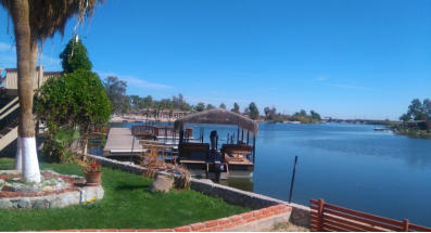
During your stay in Mexicali you can't miss visiting any of its ranches that offer entertainment for all ages.
The Campo turístico Mosqueda (Mosqueda tourist camp), located on the Mexicali-San Felipe highway, offers palapas with grills on the banks of the river. It is ideal for ecotourism activities. In addition, you can take tours of the sierra Cucapá (Cucapa mountain) or take a Canopy with hanging bridges and zip line. It is also possible to rent a boat and sail the waters of the Hardy River, the only navigable river in Baja California.
At Rancho Las Truchas, horseback riding is the order of the day. If you prefer, you can rent a pedal boat or go ziplining. The most adventurous will immerse themselves in a mountain bike circuit.
Finally, the Mirador is the favorite of local families to enjoy a day of Picnic thanks to the offer of palapas and grills. Here you can practice sport fishing. The little ones will be delighted with the water activities that the ranch offers, as well as its children's play area.
https://www.visitmexico.com/en/baja-california/mexicali
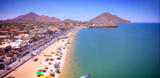
Mexicali Tourism (English version)
https://youtu.be/kuBvWZSIzEA
6. History
Early history
The Spaniards arrived in the area after crossing the Sonoran Desert's "Camino del Diablo" or Devil's Road. This led to the evangelization of the area by Catholic missionaries and also to the reduction of native populations in the region. Nowadays, indigenous Cocopah people still inhabit a small government-protected corner of the Colorado River delta near the junction of the Hardy and the Colorado. The Cocopah mostly work on agricultural ejidos or fishing.
The early European presence in this area was limited to Anza's and subsequent Spanish expeditions across the Colorado Desert and subsequent travelers on the Sonora Road opened by them. Also the presence of the Jesuits who attempted to establish a mission in what is now Fort Yuma. They left after a revolt by the Yuma in 1781. After this, the Spanish had little to do with the northeastern corner of the Baja California Peninsula, perceiving it as an untamable, flood-prone desert delta. Later in the 1820s, the Mexican authorities reopened the Sonoran Road and restored peaceful relations with the Yuma People.
The Sonoran Road provided a route for American fur trappers, and later American troops of Kearny and Cooke passing through the area during the Mexican–American War. The annexation of most of Alta California soon was followed by the California Gold Rush that saw a flood of gold seekers from Mexico on the Sonora Road, especially from Sonora, and from the United States via the Southern Emigrant Trail. Herds of cattle and sheep were driven into California across this desert trail also.
This route became a U.S. Mail and stagecoach route in 1857 when the San Antonio-San Diego Mail Line and in 1858 Butterfield Overland Mail route passed along the Alamo and New Rivers and established stations there including its New River Station in the vicinity of a Laguna along the New River in what is now Colonia Hidalgo, Mexicali in 1858. This mail route remained in use until 1877 when the Southern Pacific Railroad came to Yuma making it obsolete.
Late 19th century
In the mid-19th century, a geologist working for the Southern Pacific Railroad came to the delta area, discovering what the native Yumans had known for centuries: that the thick river sediment deposits made the area prime farming land. These sediments extended far to the west of the river itself, accumulating in a shallow basin below the Sierra de Cucapá. However, from this time period until the 1880s, the area was almost completely unpopulated, mostly due to its harsh climate. In 1888, the federal government granted a large part of northern Baja state, including Mexicali, to Guillermo Andrade, with the purpose of colonizing the area on the recently created border with the United States. However, around 1900, the only area with any real population, aside from the Cocopah, were concentrated in Los Algodones, to the east of Mexicali.
20th century
In 1900, the U.S.-based California Development Company received permission from the government of Díaz to cut a canal through the delta's Arroyo Alamo, to link the dry basin with the Colorado River. To attract farmers to the area, the developers named it the "Imperial Valley". In 1903, the first 500 farmers arrived; by late 1904, 405 km² (100,000 acres) of valley were irrigated, with 10,000 people settled on the land harvesting cotton, fruits, and vegetables. The concentration of small housing units that straddled the border was called Calexico on the U.S. side and Mexicali on the Mexican side. Led by Los Angeles Times publisher Harry Chandler, one company controlled 800,000 hectares of land in northern Baja California by 1905, and began to build the irrigation system for the Valley. However, instead of using Mexican labor to dig the ditches, Chandler brought in thousands of Chinese laborers. Mexicali became culturally Chinese influenced.
The Mexican side was named Mexicali (a portmanteau composed of "Mexico" and "California") by Coronel Agustín Sanguinéz. Initially the area belonged to the municipality of Ensenada. The town of Mexicali was officially created on 14 March 1903 when Manuel Vizcarra was named as the town's first authority and Assistant Judge (juez auxiliar). On January 29, 1911, Mexicali was briefly "liberated" by the Liberal Party of Mexico during the Mexican Revolution. Mayor Baltazar Aviléz declared the municipality of Mexicali on November 4, 1914 and called for elections to creation of the first ayuntamiento or municipality, which was then headed by Francisco L. Montejano.
In the 20th century, the Colorado Riverland Company, a U.S.-based company, was dedicated to renting Mexican land to farmers; however, these farmers were almost always foreigners, such as Chinese, East Indians and Japanese. Mexicans were employed only as seasonal laborers. This situation led to the agrarian conflict known as the "Asalto a las Tierras" (Assault on the Lands) in 1937. in which Mexican land was taken by Mexicans.
Agricultural production continued to increase during the 20th century. Cotton became the most important crop and helped develop the textile industry. In the early 1950s, the Mexicali Valley became the biggest cotton-producing zone in the country and in the 1960s, production reached more than half a million parcels a year. Currently, the Valley still is one of Mexico's most productive agricultural regions, mostly producing wheat, cotton and vegetables. The city of Mexicali is one of Mexico's most important exporters of asparagus, broccoli, carrots, green onions, lettuce, peas, peppers, radishes and tomatoes to the world.
The government of the municipality was reorganized when the Baja California territory became the 29th state in 1953.
The first factories appeared in the 1960s with the end of the Bracero program. A 1988 study found 100 factories in the city, including 10 electronics manufacturers, 25 auto parts manufacturers,27 textile plants and nine plastics companies. Most maquiladoras are run by US companies, followed by Mexican, South Korean, and Japanese companies.
21st century
Today Mexicali is an important center for maquiladora (assembly plant) production in the automotive, aerospace, telecommunications, metallurgical, and health items as well as manufacturing and exporting products to various countries.
The 2010 Baja California earthquake occurred on Easter Sunday about 60 km south-southeast of Mexicali. This very large magnitude 7.2 earthquake occurred at 15:40:40 local time (UTC−8) according to the U.S. Geological Survey. With a maximum Mercalli intensity of VII (Very strong), it was felt in northern Baja California near the United States–Mexico border, and was also felt in western cities such as Tijuana, San Diego, Los Angeles and parts of Arizona.
7. Other Information: La Chinesca
The city claimed to have the largest per capita concentration of residents of Chinese origin in Mexico, around 5,000 until 2012 when the Tijuana La Mesa District surpassed that number at 15,000 Chinese immigrants. The Chinese immigrants came to the area as laborers for the Colorado River Land Company, an American enterprise which designed and built an extensive irrigation system in the Valley of Mexicali. Some immigrants came from the United States, often fleeing anti-Chinese policies there, while others sailed directly from China. Thousands of Chinese were lured to the area by the promise of high wages, but that never materialized.
8.Contact Information
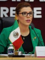
City Mayor: Marina del Pilar Ávila Olmeda
Phone number: +52 (686) 558 1600, ext.: 1602, 1603
E-mail: marinadelpilar@mexicali.gob.mx
Facebook: https://www.facebook.com/MarinadelpilarBc
Twitter: https://twitter.com/MarinadelPilar
Website: https://www.mexicali.gob.mx/XXIII
Govt. Office Address: Palacio Municipal, calz. Independencia 998, 2do. piso, Centro Cívico, 21000, Mexicali, Baja California
