Tulancingo, Hidalgo 作者: 来源: 发布时间:2021-11-17
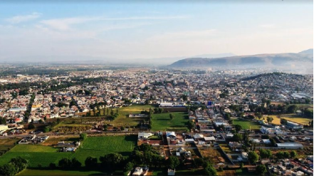
1.Population and Area
Pop: 151,582 (city)
Area: 290.4 km2 (munip.)
Elev: 2,181 masl
2. Natural geography
Nature and weather
Orography and hidrography
It is located in the Neovolcanic Axis formed mainly by plains, its topography presents a semi-flat surface, cut by ravines, ravines, hills and volcanoes. The soil is semi-desert type, rich in organic matter and nutrients.
Regarding hydrology, one of the most important rivers is the Metztitlán, which originates in the limits of the state of Puebla, which gives rise to the Río Chico de Tulancingo, which is formed by the runoff from Cuasesengo and La Paila, both form the Río San Lorenzo, which gives rise to the Río Grande de Tulancingo.
Flora and fauna
The flora of this municipality has a vegetation composed of pine, ocote, oyamel, cedar, walnut and buzzard.
The fauna belonging to Tulancingo de Bravo, is mostly made up of species such as rabbits, squirrels, rodents, hummingbirds, sparrows, woodpeckers, vipers, owls, badgers, quails, pigeons, opossums, buzzards, as well as a great variety of insects. .
http://www.inafed.gob.mx/work/enciclopedia/EMM13hidalgo/municipios/13077a.html
Köppen Classification: Marine West Coast Climate
This area is characterized by equable climates with few extremes of temperature and ample precipitation in all months. It is located poleward of the Mediterranean climate region on the western sides of the continents, between 35° and 60° N and S latitude. Unlike their equatorial neighbors, marine west coast climates are located beyond the farthest poleward extent of the subtropical anticyclone, and they experience the mid-latitude westerlies and traveling frontal cyclones all year. Precipitation totals vary somewhat throughout the year in response to the changing location and intensity of these storm systems, but annual accumulations generally range from 500 to 2500mm (20 to 98 inches), with local totals exceeding 5000mm (197 inches) where onshore winds encounter mountain ranges. Not only is precipitation plentiful but it is also reliable and frequent. Many areas have rainfall more than 150 days per year, although the precipitation is often of low intensity. Fog is common in autumn and winter, but thunderstorms are infrequent. Strong gales with high winds may be encountered in winter. Temperatures in the winter tend to be mild, while summer temperatures are moderate.
The Köppen Climate Classification subtype for this climate is "Cfb". (Marine West Coast Climate).
The average temperature for the year in Tulancingo is 60.0°F (15.6°C). The warmest month, on average, is May with an average temperature of 65.0°F (18.3°C). The coolest month on average is January, with an average temperature of 55.0°F (12.8°C).
The highest recorded temperature in Tulancingo is 95.0°F (35°C), which was recorded in May. The lowest recorded temperature in Tulancingo is 32.0°F (0°C), which was recorded in January.
There are an average of 87.0 days of precipitation, with the most precipitation occurring in July with 13.0 days and the least precipitation occurring in January with 2.0 days.
In terms of liquid precipitation, there are an average of 87.0 days of rain, with the most rain occurring in July with 13.0 days of rain, and the least rain occurring in January with 2.0 days of rain.
http://www.weatherbase.com/weather/weather-summary.php3?s=243667&cityname=Tulancingo%2C+Hidalgo%2C+Mexico&units=
Getting there and around
Get there
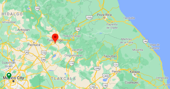
By car – The distance between Mexico City and Tulancingo is 108 km. The road distance is 118.1 km. It takes approximately 1h 20m to drive from Mexico City to Tulancingo.
By bus – The cheapest way to get from Mexico City to Tulancingo is to bus which costs $150 - $310 and takes 2h 38m.
Riseshare – Check out Blablacar's carpooling service for rideshare options between Mexico City and Tulancingo. A great option if you don't have a driver's licence or want to avoid public transport.
https://www.rome2rio.com/s/Mexico-City/Tulancingo
Car Rental – To explore Mexico’s provincial towns and cities—including its beach locations and the scenery and attractions near them— consider renting a car for your visit. Having your own car will give you more flexibility than using public transport options and, in some cases, offer you access to places which are otherwise difficult to visit without the use of a car.
COVID19 – International entry into Mexico from United States
Allowed for: All visitors arriving by air. Mexico land borders are closed to non-essential travel
Restricted for: There are no current restrictions.
Get around
Local Buses – Local buses and mini-buses (combis or micros) are available locally for a fraction of the cost of a taxi around town. You need to speak Spanish to be able to ask for directions or ask the driver to tell you where to get off.
Taxis – Taxis in most of Mexico’s towns and cities are not metered, so agree your price before you get in. Taxi travel is very affordable in Mexico, in comparison to the USA, Canada and Europe, and so provides a viable means of public transportation in Mexico. Your hotel can arrange taxis for you; some post their rates on a board in the lobby; taxi hotel rates are usually higher than cabs you hail off the street. If you speak Spanish, you will have a distinct advantage and be able to negotiate a price with the driver.
Uber is expanding rapidly across Mexico and now offers services in cities across the country, including: Mexico City, Toluca, Cuernavaca, Puebla, Querétaro, León, Aguascalientes, San Luis Potosí, Guadalajara, Monterrey, Hermosillo, Tijuana, Mexicali, and Mérida. Uber has been adding Mexican cities to its network every year, check for availability when you arrive at your destination in Mexico.
Cabify and Didi are also developing and currently operate in cities including Mexico City, Toluca, Monterrey, Puebla, Querétaro and Tijuana. Check for availability in the city you are visiting.
These services offer people with smartphones a way to book a cab through a mobile app for a pre-agreed price. Fares are comparable with Sitio type cabs, and sometimes trade at a premium to this when local demand increases.
https://www.mexperience.com/transport/taxi-travel-in-mexico/#51
3. ECONOMY
GDP: 18,580 M MXN (2010)
https://imco.org.mx/ciudades2010/ciudades/18_Tulancingo.html
4. Industry characteristics
The economy of the municipality divides into three sectors, agriculture, manufacturing, industry and mining and commerce. Agriculture employs 5.9% of the population, manufacturing, industry and mining employ 30.5% and commerce employs 63.6%.
The soil is semi arid and fertile. Just over sixty percent of the municipality's land is used for agriculture, pastures and for forest products. There is both seasonal and year-round irrigated agriculture practiced in the municipality. Major crops include corn, barley, beans, wheat and animal feed. Most crops are produced seasonally with the total corn crop divided equally between seasonal and irrigated lands. Crops produced year round and usually irrigated include cactus fruit (tunas), alfalfa and hay. Livestock includes cattle, pigs, goats, sheep, horses and domestic fowl. Pine and some other trees are harvested for wood, but this is heavily regulated.
The area is an important dairy product producer as well as a producer of cider, made from locally grown apples.
The city is known as the premier wool textile center in the country, specializing in thread and yarn, cashmeres, blankets, as well as embroidered blouses and skirts. During the pre-Hispanic era, this area produced cotton textiles, especially in the mountain areas of Huehuetla and Tenango. These were part of the tribute items collected by the Aztecs. Textile production continued into the colonial period, especially to mining communities in the Real del Monte and Pachuca areas. Sometime during this period, the fabric produced switched to mostly wool. During the late 19th and early 20th centuries, the textile industry here and in the rest of Mexico was modernized and the first train station was opened to ship products. The Mexican Revolution disrupted train service and the textile industry here suffered but came back after the war was over led by the La Esperanza and Santiago Textil factories, and with about 21% of the wool fabric of the country produced here. The textile industry continued to develop with the production of dairy products becoming important as well.
Other industry includes food processing, bottling, tobacco products, textiles, leather goods, wood and paper products, printing, chemicals, plastics and more. The three most important as far as employment are food processing, tobacco and textiles. Handcraft production centers mostly on pottery, making everyday items such as jars, cups and plates. Another craft is the making of leather goods such as sandals, chaps, gloves, etc. Textile items are usually made of wool and include sarapes and rebozos. Pottery includes both burnished and glazed objects. One unique handcrafted item is a type of “God’s eye” called a “tenango.”
The city has grown rapidly over the past 20 or so years as multinational corporations have moved operations here. However, this growth has put inflationary pressure on goods and services, especially basic foodstuffs as transportation connections here are not as good as in other Mexican cities and foreign interests can pay more for goods. There is still large scale unemployment and underemployment in the area, with many migrating to the United States. Many are men who have moved to Dallas and specialize in selling ice cream.
Key project: Parque Aventura Tulancingo
In the Tezontle Hill the development of a great attraction will strat during the first semester of the year consisting of a multi-adventure circuit of aerial challenges.
There will be a socialization scheme around this new project, mainly so that the impact and objectives to give life to the top part of the municipality can be known.
The circuit project includes a climbing wall, empty jump and zip lines by a company specialized in high altitude parks.
The new component will be called Adventure Park in Zoo having the premise of ample security throughout the journey and with simple to operate equipment.
The attraction is aimed at children six years and older and is made up of various challenges such as: rope bridge, floating islands and logs as well as hanging barrel, wooden zigzag, aerial bike, ladder with hanging swings, crossing climbing wall, To cite part of the high altitude games.
https://www.newshidalgo.com.mx/parque-de-aventura-en-zoologico-de-tulancingo
5. Attractions
Huapalcalco Archaeological Site
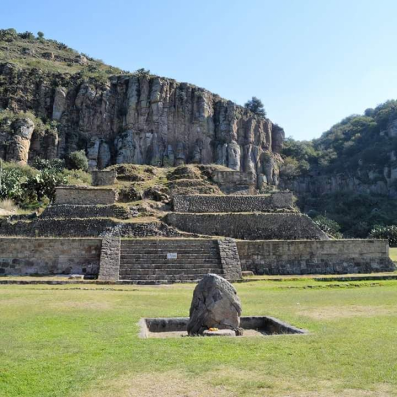
The Zona Arqueológica de Huapalcalco (Archaeological Site of Huapalcalco) is 3-kilometers Tulancingo center. It’s considered the oldest human settlement in Hidalgo for preserving cave paintings over 13 thousand years old.
The Huapalcalco region was considered the most important in prehispanic population, since the first Toltecas settled there. Here you can see the hillside of Cerro del Tecolote and two architectural complexes.
Explore the three-bodies and Teotihuacan-influence pyramid of 12 meters in base and eight in height, where possibly an altar was used as an offerings deposit.
The site has five occupations. The first one corresponds to Prehistoric with the presence of projectile points of the Meserve type, as well as cave paintings located on the Cerro de la Mesa and El Tecolote.
The second occupation is based on the late Preclassic; the third is a settlement represented by structure VI, which is also the most important since it reflects the architectural style. The fourth occupation is a small population established in the late Postclassic.
According to researchers at the site, important findings have been done, such as two yokes of Totonaca origin and a sculpture of the Dios Viejo del Fuego (Old God of Fire).
https://www.visitmexico.com/en/hidalgo/tulancingo/huapalcalco-archaeological-site
Exhacienda de Exquitlán
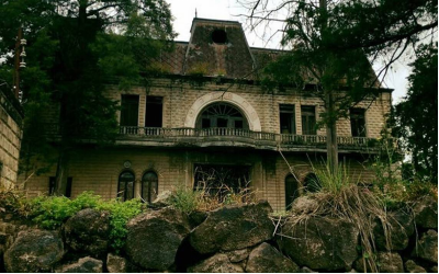
With an impressive art nouveau decoration, the Exhacienda de Exquitlán was built in 1908 by the landowner Don Pánfilo García Otamendi. Inside, the building had 20 rooms, several halls and dining rooms with angels, cherubs, landscapes and female faces in plaster. Don’t miss its extensive garden with a chapel.
It’s one of the oldest and most majestic buildings in the region, but after it was inaugurated the owner decided to sell it.
Later it was divided into two properties, one occupied by Bodegas de Exquitlán, famous for making an authentic hundred percent natural cider.
This factory started in 1930 as a family business, but since 1950 it has become the most popular firm delighting generations of good cider connoisseurs.
Tulancingo Zoo
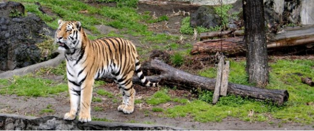
Interactive activities, talks and guided tours are part of the program that the Tulancingo Zoo has prepared for you. It’s the ideal place to spend family time admiring the animals.
Put on comfortable clothes and shoes so that you can start a tour—you’ll see more than 390 species. Bears, tigers, lions, black jaguar, ocelot, llamas, crocodiles, hippos, primates and reptiles are just some of them.
The zoo has green areas, food court and parking. Because it is in Cerro del Tezontle, it’s recommended to go until the viewpoint for enjoying the panoramic views of the Tulancingo Valley surrounded by natural landscapes.
It’s said that the hill was a faithful witness of the first settlements in the region. It is composed of volcanic stone, from which more than half a million cubic meters have been extracted for use in construction materials.
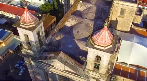
Tulancingo, Hgo. México Dirección de Turismo
https://youtu.be/dYT69lkhmlQ
6. History
The area is home to some of the oldest settlements in Latin America in Huapalcalco and El Pedregal. These first settlements have been attributed to the Olmecs, Xicalancas and other tribes. A city was founded in 645 BCE by the Toltecs with the name Tolancingo as part of the empire centered in Tula. During this period, the city was home to school and temples. A calendar stone was sculpted here and a temple called Mitlancalco was built to receive the bodies of priests and princes. After 1116 CE, the Toltec Empire declined and the city was abandoned.
According to the Tribute Codex (Códice de los Tributos), the Tulancingo area was a commercial center for the Otomi-Tepehua and Totonaca people since about 1000 CE bringing traders from lands now in the states of Hidalgo, Puebla and Veracruz. Traditional trading still exists in the form of the Thursday “tianguis” or market.
The Chichimecas came to rule here under Xolotl starting around 1120. The city was refounded by these people and the remaining Toltecs. The population increased with the arrival of the Tlaxcaltecas. In 1324, a king named Quinantzin, reorganized the area politically, making Tulancingo the head of a province. Tulancingo marched against Texcoco, but was defeated. In the early 15th century, this same Texcoco, under Huitzilihuit, conquered Tulancingo, putting it within the Aztec Empire. In 1431, the Tulancingo area was again reorganized politically under Itzcoatl and Nezahualcoyotl.
During the Spanish Conquest, Prince Ixtlilxochitl gathered an army here to join Hernán Cortés to conquer Tenochtitlan. Officially, the area came under Spanish rule in 1525, and evangelists arrived soon afterwards. The Franciscans arrived from Texcoco to build a hermitage in the Zapotlan neighborhood. This would eventually become the modern cathedral, consecrated to John the Baptist. This was the beginning of the European city, which was initially constructed for the use of Europeans only; no indigenous were allowed to live there. Those indigenous who worked in city were obliged to live outside it on the outskirts at the base of the Cerro del Tezontle. Today this area is known as Colonia Francisco I. Madero and is part of the city proper.
The Valley of Tulancingo was partitioned between Francisco de Avila and Francisco de Terrazas. The fertile soil and warm climate attracted many Spanish settlers, especially older ones. In time, the area became known as the “Retiring place of Old Conquistadors.”
During the Mexican War of Independence, the city was attacked several times by insurgents in 1812, 1814 and 1815. However, royalist forces were able to hold the city until Nicolás Bravo and Guadalupe Victoria took it in 1821, near the very end of the war. Bravo remained here for a time, founding a newspaper called El Mosquito de Tulancingo and constructing a gunpowder factory. This would lead to “de Bravo” being added as an appendage to the city's name in 1858. After Agustín de Iturbide was proclaimed emperor in 1822, he maintained a residence in Tulancingo, where he was supported by the populace. When Iturbide was dethroned, he withdrew from Mexico City to Tulancingo on his way to Veracruz and into exile.
Under the 1824 Constitution, Tulancingo was head of a district of the then enormous State of Mexico, which today are the states of Mexico, Hidalgo, Morelos and Guerrero. The Tulancingo district included the areas around Apan, Otumba, Pachuca, and Zempoala.
Despite the ouster of Iturbide, Tulancingo favored a centralist form of government, rather than the state-based federalist one. It would provide refuge to centralists such as Nicolas Bravo during most of the 19th century. Bravo's forces were attacked here by federalist forces under Vicente Guerrero in 1828. Guerrero was victorious and Bravo fled into exile. In 1853, dictator Santa Anna imprisoned federalist Melchor Ocampo in the city. Because the city was loyal to the centralist cause, Ocampo was not placed in prison, but rather allowed to walk the streets where the citizens would supervise him. This continued until Santa Anna decided to send Ocampo out of the country.
During the French Intervention in Mexico, the large State of Mexico was divided into three military districts for defensive purposes. The one in which Tulancingo belonged would eventually become the state of Hidalgo. President Benito Juárez could not hold Tulancingo and French troops entered in 1863. French emperor Maximilian I would use the same house in this city that Iturbide used before. This emperor divided the country into fifty departments, making Tulancingo the head of one of them.
In 1863, Tulancingo made the city the head of a see, under the archbishopric of Mexico City, despite desires to have the head of this see in Huejutla. Its territory included parishes from Puebla, Hidalgo and Mexico State. Soon after Juárez and the federalists ousted the Emperor Maximilian, the state of Hidalgo was created. Tulancingo was considered as a place to locate the new state's capital but Pachuca was chosen instead.
During the Mexican Revolution, forces loyal to Francisco I. Madero under Gabriel Hernandez took Tulancingo in 1910. Madero himself visited in 1912. Forces loyal to Venustiano Carranza took the city in 1915, with Carranza visiting in 1916.
The municipal territory contains a number of small rivers and streams as well as mountainsides, making it susceptible to flooding. Two most recent major floods occurred in 1999 and 2007. Major flooding occurred in and around the city in 1999, with communities such as La Rosa, on the outskirts, the hardest hit, when rivers and streams overflowed. The flooding was caused by heavy and prolonged rainfall which affected several states in the region. Over 500 houses were abandoned in the city at the height of the disaster. Hurricane Dean caused flooding damage again in 2007, when in less than 12 hours of rain, eighteen colonias were underwater with water pouring off mountainsides. Many houses were completely destroyed and a number flooded by sewerage. Those here were among the estimated 100,000 affected in Hidalgo state.
7.Contact Information

City Mayor: Fernando Pérez Rodríguez
Phone number: +52 (775) 755 8450
E-mail: presidencia@tulancingo.gob.mx
Facebook: https://www.facebook.com/fernando.perezrodriguez.393
Twitter: https://twitter.com/Ferperez_tuvoz
Website: https://sitio.tulancingo.gob.mx
Govt. Office Address: Blvd. Nuevo San Nicólas S/N, 43640, Tulancingo, Hgo.
