Tehuacán, Puebla 作者: 来源: 发布时间:2021-11-17
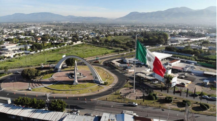
1.Population and Area
Pop: 274,906 (city)
Area: 27.83 km2 (city)
Elev: 1,600 masl
2. Natural geography
Nature and weather
Orography
A geographical factor to consider about the region of Oaxaca and Tehuacan valley is the telluric area where the city is located. Tehucan is surrounded by the Neovolcanic Axis that covers the states of Nayarit, Jalisco, Colima, Michoacán, Guanajuato, Querétaro, México, Hidalgo, Morelos, Tlaxcala, Puebla and Veracruz. This Axis connects the main active volcanoes of the region and because of this volcanic activity the city presents continuous movements of Earth, specially during summer and spring seasons.
The municipality is made up of 3 morphological regions, it belongs to the Sierra Zangólica, Sierra de Zapotitlán and Sierra Negra. It occupies 1.15% of the surface of the state, which places it in 18th place with respect to the other municipalities in terms of extension. within its limits are the hills of Las Chivillas, Mojada, El Muerto, Cerro Viejo, Coatepec, La Tarántula, Ocotempa, Maguey, El Gavilán, and Cerro Colorado.
The municipality of Tehuacán borders on the north with the municipalities of Tapanco de López, Santiago Miahuatlán, Nicolás Bravo, Vicente Guerrero, San Antonio Cañada, Ajalpan, San Gabriel Chilac and Zapotitlán, on the west with Atexcal, J.N. Méndez, Tlacotepec de Bto. Juárez and Tapanco de López.
Hydrography
The municipality belongs to the basin in the Papaloapan. It is watered by the currents coming from the surrounding mountains to the Tehuacán Valley. From the Sierra de Zongolica, the Río La Huertilla stands out, which joins the Río Salado and Tehuacán and forms the river of the same name that eventually reaches Dominguillo and discharges into the Papaloapan.
In the area there are a large number of mineral water springs, such as those of El Riego Garci-Crespo, San Lorenzo, Peñafiel, San Miguelito and others. As there is a large number of springs, runoffs and underground water filtering galleries, which cross a large part of the City of Tehuacán.
99.56% of the municipal surface is located within the Papaloapan RH28 Hydrological Region, within the basin of the same name, in which the sub-accounts of the Blanco River differ. The remaining 0.44% is found in the Balsas Hydrological Region, Atoyac Sub-basin. The La Huertilla River stands out, which joins the Tehuacán channel and forms the river of the same name. This tributary becomes one of the main formators of the Papaloapan downstream.
Specifically, from the Sierra de Zongolica there are numerous streams that bathe the east and northeast, towards the Tehuacán Valley, where the Tehuacán hydraulic corridor begins, formed by the topographic narrowing between the hills of the Sierra Negra to the northeast and San Lorenzo Teotipilco to the south.
That is, in the municipality there are several mineral springs, among which El Riego stands out, which is exploited by the bottling company of the same name, San Lorenzo, Garci-Crespo, also used by the bottling company of the same name, Santa Cruz, La Granja. , San Miguelito, among others.
Flora and fauna
The floristic province called Tehuacán-Cuicatlán, located in the southeastern part of the State of Puebla and northeast of the State of Oaxaca, is part of the Mexican xerophytic region. The Tehuacán-Cuicatlán Valley, despite being located in two federative entities and being of great extension, constitutes a single biogeographic unit of worldwide relevance mainly due to the wide range of hahitas and species of wild fauna and flora representative of the national biodiversity. including some of the latter in the endemic, threatened and endangered categories. According to the decree declaring the Tehuacán-Cuicatlán Biosphere Reserve (1998) there are more than 3,000 superior plant and animal species in this area, among which cacti stand out. Thus, in the Tehuacán Valley there are the following types of vegetation: rosetifolio desert scrub (occupying 40%), crasicaule scrub (28%), low deciduous forest (25%) and oak pine forest (7%). The forests of arborescent columnar cacti with roofs (Neobuxbaumia sp.), Cardonal (Pachycereus sp., Mitrocereus sp.), Sotolín or elephant's foot (Beurcanea gracilis), thickets with izotes (Yucca periculosa), lettuce (Hechtia pootesha), cuajildant (Bursera arida), thorny bushes with nopales (Opuntia sp.), Biznagas (Ferocactus sp., Mammillaria sp.), Garambullos (Myrtillocactus sp.), Mesquite (Prosopis sp.), Agaves (Agave sp.), Mother-in-law seats (Echinocactus platyacanthus) and pine-oak forests (Pinus sp., Quercussp.).
The fauna of Tehuacán is less known than the flora, but it can be said that it is made up of species such as ants, termites, snakes, black iguanas, green iguanas, lizards, rabbits, bears, squirrels, field hare and small birds such as Woodpeckers, quail, chichicuilotes, pigeons, owls, Mexican sparrows, hummingbirds, buzzards, swallows and hawks. Among the vertebrates can be included the great variety of amphibians and reptiles, bats and birds; there are also a great variety of scorpions, teporingos which are very characteristic of the region, and alicantes.
Tehuacan Valley presents a high diversity of plant and animal species, especially the Tehuacan-Cuicatlán Biosphere Reserve located 30 minutes southwest from Tehuacan, that belongs to the city and protects 200 Cactus species, most of them endangered types.
Köppen Classification: Marine West Coast Climate
his area is characterized by equable climates with few extremes of temperature and ample precipitation in all months. It is located poleward of the Mediterranean climate region on the western sides of the continents, between 35° and 60° N and S latitude. Unlike their equatorial neighbors, marine west coast climates are located beyond the farthest poleward extent of the subtropical anticyclone, and they experience the mid-latitude westerlies and traveling frontal cyclones all year. Precipitation totals vary somewhat throughout the year in response to the changing location and intensity of these storm systems, but annual accumulations generally range from 500 to 2500mm (20 to 98 inches), with local totals exceeding 5000mm (197 inches) where onshore winds encounter mountain ranges. Not only is precipitation plentiful but it is also reliable and frequent. Many areas have rainfall more than 150 days per year, although the precipitation is often of low intensity. Fog is common in autumn and winter, but thunderstorms are infrequent. Strong gales with high winds may be encountered in winter. Temperatures in the winter tend to be mild, while summer temperatures are moderate.
The Köppen Climate Classification subtype for this climate is "Cfb". (Marine West Coast Climate).
The average temperature for the year in Tehuacán is 64.4°F (18°C). The warmest month, on average, is May with an average temperature of 69.8°F (21°C). The coolest month on average is January, with an average temperature of 57.9°F (14.4°C).
The highest recorded temperature in Tehuacán is 102.2°F (39°C), which was recorded in April. The lowest recorded temperature in Tehuacán is 23.0°F (-5°C), which was recorded in January.
The average amount of precipitation for the year in Tehuacán is 18.0" (457.2 mm). The month with the most precipitation on average is June with 3.9" (99.1 mm) of precipitation. The month with the least precipitation on average is December with an average of 0.1" (2.5 mm). In terms of liquid precipitation, there are an average of 64.6 days of rain, with the most rain occurring in September with 11.0 days of rain, and the least rain occurring in December with 1.1 days of rain.
http://www.weatherbase.com/weather/weather-summary.php3?s=921083&cityname=Tehuac%E1n%2C+Puebla%2C+Mexico&units=
https://tinyurl.com/y5expl7x
Getting there and around
Get there
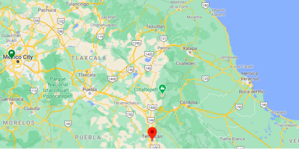
By car – The quickest way to get from Mexico City to Tehuacán is to drive which costs $440 - $650 and takes 2h 58m. The distance between Mexico City and Tehuacán is 211 km. The road distance is 251.2 km.
By bus – The cheapest way to get from Mexico City to Tehuacán is to bus which costs $300 - $500 and takes 4h. there is a direct bus departing from Mexico City and arriving at Tehuacán. Services depart hourly, and operate every day.
ADO bus from Puebla (CAPU) every half hour, takes two hours. ADO first class bus service also from Oaxaca.
https://www.rome2rio.com/s/Mexico-City/Tehuac%C3%A1n
Car Rental – To explore Mexico’s provincial towns and cities—including its beach locations and the scenery and attractions near them— consider renting a car for your visit. Having your own car will give you more flexibility than using public transport options and, in some cases, offer you access to places which are otherwise difficult to visit without the use of a car.
COVID19 – International entry into Mexico from United States
Allowed for: All visitors arriving by air. Mexico land borders are closed to non-essential travel
Restricted for: There are no current restrictions.
Get around
Local Buses – Local buses and mini-buses (combis or micros) are available locally for a fraction of the cost of a taxi around town. You need to speak Spanish to be able to ask for directions or ask the driver to tell you where to get off.
Taxis – Taxis in most of Mexico’s towns and cities are not metered, so agree your price before you get in. Taxi travel is very affordable in Mexico, in comparison to the USA, Canada and Europe, and so provides a viable means of public transportation in Mexico. Your hotel can arrange taxis for you; some post their rates on a board in the lobby; taxi hotel rates are usually higher than cabs you hail off the street. If you speak Spanish, you will have a distinct advantage and be able to negotiate a price with the driver.
Uber is expanding rapidly across Mexico and now offers services in cities across the country, including: Mexico City, Toluca, Cuernavaca, Puebla, Querétaro, León, Aguascalientes, San Luis Potosí, Guadalajara, Monterrey, Hermosillo, Tijuana, Mexicali, and Mérida. Uber has been adding Mexican cities to its network every year, check for availability when you arrive at your destination in Mexico.
Cabify and Didi are also developing and currently operate in cities including Mexico City, Toluca, Monterrey, Puebla, Querétaro and Tijuana. Check for availability in the city you are visiting.
These services offer people with smartphones a way to book a cab through a mobile app for a pre-agreed price. Fares are comparable with Sitio type cabs, and sometimes trade at a premium to this when local demand increases.
https://www.mexperience.com/transport/taxi-travel-in-mexico/#51
3. ECONOMY
GDP: 20,088 M MXN (2010)
https://imco.org.mx/ciudades2010/ciudades/34_Tehuacan.html
4. Industry characteristics
The main economic activities of the municipality are agriculture, livestock, industry, mining, tourism and commerce. The main economic activity of Tehuacán is the poultry industry, that is, the production of eggs and chicken, which places it in second place in the national production in this area. On the other hand, the clothing industry occupies an important place in the domestic economy, although it has declined alarmingly in the last two decades.
Poultry farming
Tehuacán is an average city with a population of 319,375 inhabitants and one of the most booming productive activities is the poultry industry, which places it in second place in national production in the production of plate eggs. The poultry industry is made up of a group of companies that produce poultry and eggs that economically depend on a family, the Romero Group16 which dominates the product market; with company names and brands such as El Calvario, Mr. Egg, Avícola Tehuacán, PATSA, IMSA and ALPES17 that group more than 25 million laying and breeding birds.
The economic benefit that this activity represents is fundamental for the livelihood of many families in the region who work on farms that are located in almost every area of the Tehuacán Valley, a region that makes up the Tehuacán-Cuicatlán Biosphere Reserve. The production of eggs and chicken represents one of the main sources of employment for the inhabitants of the region and the economy of Tehuacán depends heavily on the financial performance of this item.
Textile industry
The garment industry dates back to three decades in Tehuacán. Originally, the production was focused for the domestic and local market, making dress shirts and pants, jeans and pants, uniforms, underwear and corsetry. With the imposition of neoliberalism in the national territory in the nineties, a maquila boom arises that produced a growth of the clothing industry to unsuspected levels, which led production to export, industrial expansion, automation of the processes and the generation of sources of employment that demanded labor with great avidity. In 1999, Tehuacán was declared the "Blue Jeans World Capital" by the Secretary of Economic Development of the Government of the state of Puebla. The clothing industry reached a production of 50 million garments per month, adding some 700 maquiladoras and denim laundries in the area.
During that time, the city strongly increased its population due to the immigrant population that was attracted to the city as a labor magnet because in Tehuacán “there is no unemployment”. Unplanned and disorderly urban spots began to appear on the outskirts of the city, areas lacking all kinds of urban services appeared everywhere, and the population increased day by day and in the same way the demand for services by the entire population .
The clothing industry opened a new industrial path with the denim washing industry, denim washing machines began their appearance popping up everywhere to meet the growing demand for “washed out denim” that appeared as a temporary fad. The washing of the denim was carried out exclusively using chemical solvents, whose waste was emptied by the industries into the drainage and public sewer network without any type of treatment, thereby strongly contaminating the Valsequillo Drain, the main water conduction route of irrigation of the Valley of Tehuacán and that transports the vital liquid from the dam of the same name in areas near the city of Puebla.
With the economic slowdown that the world experienced and, in particular, the United States, the maquiladora industry suffered a severe setback and went bankrupt an incalculable number of these companies producing a plethora of unemployed who sought their relocation in the denim laundries that to date operate in the area and that increased their number due to the setback of the clothing industry. This increased the amount of chemical waste dumped into the Valsequillo Drain, further exacerbating the contamination of the irrigation waters that flow there.
Farming
The main crops of the municipality are corn, alfalfa, wheat, barley and coffee. More recently sorghum has been successfully planted due to high demand from the agricultural sector. Recent investments in high-tech and controlled agriculture have achieved international status.
Over time the agricultural land has improved and depending on the region and the climate, different crops are grown; For example, in municipalities such as Cuayuca, Santiago Miahuatlán, San Bartolo Teontepec, Tlacotepec de Benito Juárez, crops of corn, beans, squash, chayote chile ancho or better known as chile miahuateco predominate, other regions such as Coxcatlán, Calipam, Zinacatepec grow fruits such as mango, peach, small sapote, as well as canary chili and beans for slaughter, of course with the support of the government greenhouses have been implemented that improve the productivity of the towns and help to improve the economy of the region. The total planted area (Hectares) was 9,398 in 2011 based on INEGI.
Cattle raising
Cattle, pigs, horses, cattle and goats are raised on pasture. Beekeeping has also gained great importance, with excellent quality products for local consumption and for export. Pigs and poultry are two of the strongest pillars of the region's economy, so much so that Tehuacán is one of the main distributors of poultry for human consumption, and eggs in the country.
Gastronomy
The gastronomy of Tehuacán and the region is rich in flavors and textures. The base of their dishes are endemic ingredients and some are only seasonal. Among the most representative traditional dishes is the mole de hips that has been made since colonial times and whose flavor is based on the raising of goats during the year, generally accompanied by a traditional drink known as lapo. The season for this dish is between the months of October and November. Other dishes and typical meals of the region are the barbecue of Santa María Coapan, the mole de guajolote from San José and Santiago Miahuatlán, the latter is characterized by being the most delicious and tasty in the entire state, donkey bread, muéganos and nopal bull, tetechas, palmitos, tempesquistles, among others of a wide gastronomic variety. Traditional drinks: pulque, mezcal, garambullo and lapo.
Industry
The industry in Tehuacán is relatively varied: the clothing, shoe, beverage and food industries. Tehuacán has an industrial park, which favors the development of local companies in addition to having excellent air and land communication routes. Due to its geographical location, it becomes a strategic investment point for Mexico.
Handicrafts
The onyx, the clay from Los Reyes Metzontla and the marble from Tehuacán and San Antonio Texcala with which different nationally and internationally recognized articles are made. Embroidered textiles are made in San Gabriel Chilac, with different designs alluding to the flora and fauna of the area.
Mining
The main deposits in Tehuacán are coal, stone, slate quarries, marble and granite.
Ethnic Festival of the Slaughter
One of the greatest traditions of Tehuacán is the mole de hips, this typical dish is made mainly in the month of October, from which the Matanza festival arises, included since 1997 in the CONACULTA festival directory and declared cultural heritage of the state of Puebla on October 22, 2004. The slaughter is a tradition that began in the early years of the seventeenth century, when goats were introduced to New Spain and thus began the gastronomic miscegenation that contributed to popular gastronomy a great variety dishes such as spinazo al mojo de ajo, spinazo al ajo arriero, udders, kidneys, tongue, head, tacos with brains, beans with goat feet and what with the skill of the cooks was created. The objective of the Ethnic Festival of the Slaughter is to integrate the most representative cultural productions of the Mixteco-Puebla region, the Oaxacan region and the Guerrero region to contribute to its dissemination.
5. Attractions
Palacio Municipal (City Hall)
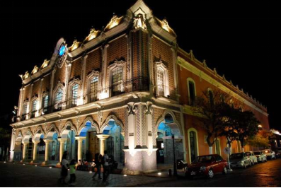
Built in the XIX century, this property was known as “La Casa de los Altos”, because at that time this was the only two-level house in the whole city of Tehuacán. The owner was José Domingo Rodríguez de Apresa.
Some years later, the house was confiscated by the church when it was known that it was bought using tithes. It was originally given to The Franciscan community, however, they decided not to use it. Years later it was offered to the Government but they couldn't take care of it, so it remained abandoned.
Time after that, the Municipality sold its old town hall –this was possible thanks to the Lerdo Law– and with the money obtained they started the rescue of “La Casa de los Altos”. They gave new life to this house and ultimately it became the new Municipal Palace.
Inside this Moorish style building you will find a mural painting that describes the history of the town named “The 5 Regions of Tehuacán” Take a close look at this painting, it covers a space from top to bottom, arches included. You will also find another one that honors one of the most popular personalities of Tehuacán and that is named “A New World”.
Finally, the clock that rounds up the whole building was the idea of Mexican Ex-President Porfirio Diaz.
https://www.visitmexico.com/en/puebla/tehuacan/palacio-municipal-city-hall
Tehuacán Viejo Archaeological Site and Museum
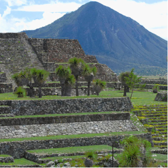
Here you will be able to see throughout its three halls a collection of 80 pieces related to the most important aspects of the old Ndachijan, better Known as Tehuacán, in Puebla.
Here you will find archeological pieces, big format sculptures in stone and mud, as well as pottery. You can also see some of the local and international ceramic work. Listen carefully to your guides so you can learn about the old trade routes that took place from Oaxaca to Puebla and Tlaxcala.
The tour includes audiovisual resources as well as 3D animations where you can see the architectural structure of the building, their religious cult and the social life that took place in Popoloca.
From here, in a 5 minutes ride you will get to the Archaeological Zone, a majestic place where you can see the antique residences of important personalities in that time. You can also take a look to the Templo Mayor and Templo de las Calaveras.
Today we can know that there are more than 120 hectares that comprise the city, but only 2 have been explored to this day. In this zone you can see the plaza Templo de Fuego Nuevo. This is a temple dedicated to Time 's renewal every 52 years. You can see the Ehécatl-Quetzalcóatl sanitarium and a central complex that includes the Templo Mayor and the Calaveras.
The place, surrounded by hills, is undoubtedly beautiful. We can assure that you will be more than happy with your visit and you will be able to know so much more about Puebla.
https://www.visitmexico.com/en/puebla/tehuacan/tehuacan-viejo-archaeological-site-and-museum
Tehuacán - Cuicatlán Biosphere Reserve
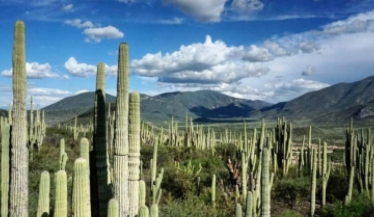
In this space full of natural richness, there are shared treasures by Puebla and Oaxaca states. You won't be able to find many of the species that live here in any other part in the world. This fact makes this place even more unique and fascinating.
An arid ecosystem stands out that build up big groups of vegetation that can be as 20 meters in height. Something you need to know is that this site was declared as Bien Mixto, this means that this place is declared both as a Cultural Heritage of Humanity and Natural Patrimony of Humanity, this thanks to its historical natural richness. Remember that here the domestication of corn took place.
In this natural reserve you can still see ocelots, cougars and jaguars. The same way, you can enjoy a diverse array of birds such as owls and golden eagles.
In order to visit the site you have to book with a certified guide since every routh is strictly under surveillance in order to preserve its natural richness for generations to come.
https://www.visitmexico.com/en/puebla/tehuacan/tehuacan-cuicatlan-biosphere-reserve
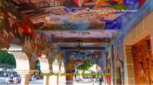
Descubre la magia de Tehuacán en Puebla
https://youtu.be/BVn6ovRvelU
6. History
The native populoca group of Tehuacán is called Popoloca. The first place that the city occupied was where the archaeological zone of La Mesa (Calcahualco) stands today, which means "cradle of the rich and elegant."
Xelhua, the Nanolka conqueror, took possession of these lands in the middle of the 15th century.
Given the fertility of their lands, they helped the production of the red pomegranate, and because of that the city is also known as Tehuacán de las granadas. Later, on August 31, 1884 by mandate of the Heroic Legislature of the State, and in memory of Don Juan Crisóstomo Bonilla, the city happened to have the name of "Tehuacán de Juan Crisóstomo Bonilla".
Tehuacán was part of the Camino Real that communicated the Port of Veracruz with Greater Tenochtitlan, which influences the construction of the Carmelite Temple in the current location.
Archaeological finds show that it was inhabited by village communities. Its remote past 8500 BC. C.
On March 16, 1660, the Indians of the region acquired from the Spanish Crown the title of Tehuacán, City of Indians, winning with their offer to the Spaniards of that time.
During the War of Independence, the city was used as a military barracks by the illustrious leader Valerio Trujano. Also, during the War of Independence, General José María Morelos y Pavón had a residence in the city of Tehuacán. In the Municipal Palace, there is a mural dedicated to this stage in the history of Tehuacán. In March 1862, the French army that invaded Mexican territory, lodged in Tehuacán. The entire state of Puebla was under the rule of the imperialists of Emperor Maximilian I of Mexico until the year 1867.
One of the legends that are told is that the Churches of the season were linked together by underground tunnels that led to Cerro Colorado, through these tunnels the locals escaped persecution and took refuge in Cerro Colorado.
The Churches that were linked by tunnels were: the Cathedral, Calvary and the Church of Carmen, apart from the fact that they used the tunnels to hide at the time of the revolution, they were used as a means of communication between the churches by the nuns, to avoid being abducted.
7.Contact Information

City Mayor: Andrés Artemio Caballero López
Phone number: +52 (238) 380 3500
Facebook: https://www.facebook.com/CaballeroLopezA
Website: http://tehuacan.gob.mx
Govt. Office Address: Av. Reforma Nte. Nº 614, Colonia Buenos Aires, C.P 75730 Tehuacán, Pue.
