Cárdenas, Tabasco 作者: 来源: 发布时间:2021-11-17
1.Population and Area
Pop: 112,558 (city)
Area: 2112 km2 (munip.)
Elev: 8 masl

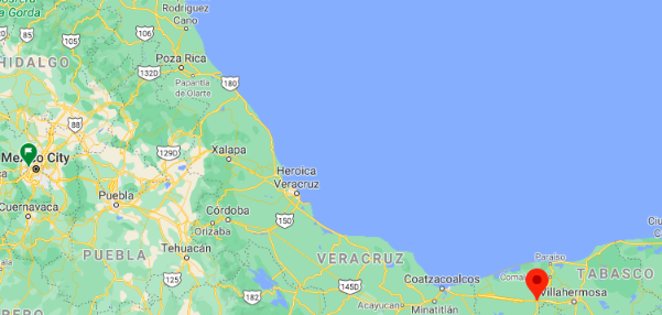
Cárdenas location in Mexico within the state of Tabasco
https://goo.gl/maps/fXcJi2UZuyfvnMJZ6
2. Natural geography
Nature and weather
Orography
The cardenese soil presents a very regular relief, composed of flat terrain with depression areas with a variable altitude between 2 and 17 meters above sea level. The municipality does not present natural elevations higher than 25 meters above sea level. The altitude of the municipal head of 10 msnm.
Most of the surface has very wet clay soils with poor drainage due to little variation in altitude. There are also sandy and saline soils in the areas near the coast and sedimentary soils on the banks and river beds.
The Cárdenas subsoil has important oil fields at the state level, making it a first-rate oil extraction zone.
Hydrography
Hydrographic resources are varied, though not as critically as in the center of the state. The eastern end of the municipality is bordered by the Mezcalapa River, which runs east until it empties into the Gulf of Mexico. In the northern part are the San Felipe, Naranjeño and Santana rivers.
In Cárdenas there is the most important lagoon system in the state; formed by the Carmen and Machona lagoons, which are classified as lagoons, separated from the Gulf of Mexico by the Santa Anna bar.
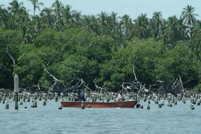
The lagoons of La Palma, Santa Teresa and El Pajaral are also located, the latter maintains an important population of birds on one of its islands, including seagulls, pelicans, herons, among others. This makes it an important environmental study post and a potential ecotourism development site.
In the northern part, the San Felipe and Naranjeño rivers flow into the Carmen lagoon and the Santana river into the La Machona lagoon. The Chicozapote River borders the town of Benito Juárez and empties into the Tonalá River near the mouth of the latter in the Gulf of Mexico. There are other rivers and streams of less importance.
Flora and fauna
The original vegetation is middle and high perfoliata forest; although most of it has given way to agricultural crops and, for the most part, to pastures for extensive cattle raising. In the areas near the bodies of water, there is hydrophilic vegetation, known as popal, forming large marshes and swamps with vegetation such as flowers, trees, tomato plants among others.
The fauna is typical of tropical regions, with various species of reptiles (especially chelonians), birds, amphibians and mammals; as well as a huge variety of invertebrates.
Weather
As in the rest of the state, the climate of Cárdenas is hot and humid with abundant rains in summer (Am). The average annual temperature in the entity is 27 ° C, the average maximum temperature is 36 ° C and occurs in the month of May, the average minimum temperature is 18.5 ° C during the month of January.
The state average precipitation is 2,550 mm per year, the rains occur all year round, being more abundant in the months of June to October.
The annual average relative humidity is estimated at 83%, with a maximum of 86% in January and February and a minimum of 77% in May.
The biggest gales occur in the months of November and December, with maximums of 30 km / h and the smallest in June, with maximums of 20 km / h.

Getting there and around
Get there
By air – The quickest way to get from Mexico City to Cárdenas is to fly and taxi which costs $950 - $1600 and takes 3h 18m, including transfers. You can fly to the Villahermosa airport and take a bus or drive from there to Cárdenas. The quickest flight from Mexico City Airport to Villahermosa Airport is the direct flight which takes 1h 20m.
By car – Cárdenas is accessible on Federal Highway 180, which links it to Villahermosa to the west and Coatzcoalcos to the east; and Federal Highway 187, which runs to Comalcalco and Paraíso to the north and Chiapas to the south.
By bus – Cárdenas is readily reached by first- and second-class buses from Villahermosa and other cities in Mexico. First-class ADO buses from Villahermosa depart nearly three times an hour at their peak, and no less than every hour at other times of the day.
https://www.rome2rio.com/s/Mexico-City/Macuspana
Car Rental – To explore Mexico’s provincial towns and cities—including its beach locations and the scenery and attractions near them— consider renting a car for your visit. Having your own car will give you more flexibility than using public transport options and, in some cases, offer you access to places which are otherwise difficult to visit without the use of a car.
COVID19 – International entry into Mexico from United States
Allowed for: All visitors arriving by air. Mexico land borders are closed to non-essential travel
Restricted for: There are no current restrictions.
Get around
Local Buses – Local buses and mini-buses (combis or micros) are available locally for a fraction of the cost of a taxi around town. You need to speak Spanish to be able to ask for directions or ask the driver to tell you where to get off.
Taxis – Taxis in most of Mexico’s towns and cities are not metered, so agree your price before you get in. Taxi travel is very affordable in Mexico, in comparison to the USA, Canada and Europe, and so provides a viable means of public transportation in Mexico. Your hotel can arrange taxis for you; some post their rates on a board in the lobby; taxi hotel rates are usually higher than cabs you hail off the street. If you speak Spanish, you will have a distinct advantage and be able to negotiate a price with the driver.
Uber is expanding rapidly across Mexico and now offers services in cities across the country, including: Mexico City, Toluca, Cuernavaca, Puebla, Querétaro, León, Aguascalientes, San Luis Potosí, Guadalajara, Monterrey, Hermosillo, Tijuana, Mexicali, and Mérida. Uber has been adding Mexican cities to its network every year, check for availability when you arrive at your destination in Mexico.
Cabify and Didi are also developing and currently operate in cities including Mexico City, Toluca, Monterrey, Puebla, Querétaro and Tijuana. Check for availability in the city you are visiting.
These services offer people with smartphones a way to book a cab through a mobile app for a pre-agreed price. Fares are comparable with Sitio type cabs, and sometimes trade at a premium to this when local demand increases.
https://www.mexperience.com/transport/taxi-travel-in-mexico/#51
3. ECONOMY
GDP: 19,566 M MXN (2010)
https://imco.org.mx/ciudades2010/ciudades/84_Macuspana.html
4. Industry characteristics
Primary sector
Since 1965, the municipality is the headquarters of the agricultural development project called Plan Chontalpa, which incorporates 352 thousand hectares of crops in the Chontalpa region, with the municipality having 52,517 hectares covered so far. Said project is still under development today since various difficulties have arisen in the different stages of its application. However, it has produced some satisfactory results.
The municipality stands out as the main state producer of sugar cane (15,557ha), cocoa (13,229ha), coconut (9,054ha) and rice (6,000ha). Other crops produced in the municipality include corn, beans, sorghum, chile (chili) and fruit crops, of which the most important are bananas and citrus fruits.
Regarding livestock, in Cárdenas this is practiced extensively, with the municipality having 117,772 head of cattle, 34,872 of pigs, 690 of sheep and 3,342 of equine cattle, as well as 345,331 poultry, according to the corresponding INEGI data. to the 2000 Economic Census.
Fishing is not another important sector of municipal production, since Cárdenas has a coastline of 66 km, as well as a large extension of inland waters. The production of oyster, snook, tarpon, dogfish, headband, moray eel, shrimp and crab stands out. Fishing for jellyfish or aguamala has recently been instituted for export to Japan. The main fishing production center is the town and port of Sánchez Magallanes.
Secondary sector
Regarding the industry, the municipality presents an important development in the sector of industrialization of agricultural products; highlighting the Benito Juárez and Santa Rosalía sugar mills, the Cacao Industrial Plant and the Chontalpa Rice Mill.
Another relevant industry is the oil industry, which has 37,879 km of oil corridors and pipelines in the municipality, with Cárdenas being the municipality with the largest number of roads or pipelines of this type in the state.
Third sector
Tourist activity takes place mainly in the coastal areas, in the Sánchez Magallanes town and port, near which the Del Carmen, La Machona and El Pajaral lagoons are located, with great potential for ecotourism development. Accommodation can be found more easily in the city of Cárdenas.
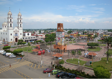
Trade is the main engine of the Carden economy, since the municipal seat is a connection point between the state capital, Villahermosa, and the north of the country through federal highway 180. Thanks to this, Cárdenas has numerous commercial establishments throughout nature, as well as with a large number of services, such as self-service stores of national chains, car agencies, banks, restaurants, pharmacies, etc.
Key project: Waste management plant
Construction of the Cárdenas regional hospital
The governor of Tabasco, Adán Augusto López Hernández, announced that the executive project for the construction of the Cárdenas regional hospital is ready.
He specified that the work will begin before the end of this year, and that it will come into operation in October or November 2021.
López Hernández said that the land is more than 5 hectares.
https://corat.mx/listo-proyecto-para-construccion-del-hospital-regional-de-cardenas
5. Attractions
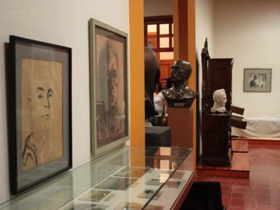
Carlos Pellicer Museum

The House Museum of Carlos Pellicer Cámara is the house where the great Tabasco poet Carlos Pellicer Cámara was born, also called "the poet of America", and is considered the "loudest voice" of twentieth century Mexican poetry. The House Museum is located in the historic center of the city of Villahermosa, Tabasco, Mexico, and the museum was inaugurated on June 11, 1985.
The museum is located in a typical Tabasco house, built in the 19th century, on one floor, with cedar wood doors and windows and a gabled roof covered in French clay tiles. Its facade is simple and it only has two masonry frames that surround the door and the only window that the house has as ornaments.
The house museum has 4 rooms inside which represent every 20 years of the life of the Tabasco poet.
The museum displays a collection of 1,559 objects that were part of the artist's daily life.1 The small museum shows the sobriety that characterized Pellicer and includes furniture, clothing, portraits, beds, inkwells, etc. Among the highlights are the wedding dress of the poet's mother, the portraits made of Pellicer by several renowned artists and the reproduction of the room that she occupied from 1952 until her death in 1977, and which was located in the old Museum of Tabasco, today renamed the Carlos Pellicer Cámara Regional Museum of Anthropology.
Laguna La Machona

This huge lagoon is connected to that of El Carmen and is barely separated from the sea by a narrow coastal strip that goes from the town of Sánchez Magallanes to Barra de Tupilco.
The vast expanse of coastline and water offers a series of attractive beaches and charming corners, ideal for enjoying the climate, the vegetation and the company of countless tropical birds.
In these places you will find some fishing villages where you can taste a simple stew prepared with seafood or organize a boat trip around the surroundings to observe the flora and fauna of the region.
Ensueño Beach
This spa has approximately 4 kilometers of beach, very visited especially in the summer.
It is located on the coast of the Gulf of Mexico, in the town and port of Sánchez Magallanes, with a beach 4 km long by 60 m wide. It has fine sand, sloping to gentle waves, and the water is blue, warm and shallow up to 50m offshore, elements that make the stay pleasant for the visitor who likes contact with nature. It is accessible by road and is located at a distance of 93 km from the municipal seat.
http://www.inafed.gob.mx/work/enciclopedia/EMM27tabasco/municipios/27002a.html

A dónde ir? / Los Lagos Cárdenas, Tab.
https://youtu.be/6gogKHU-aog
6. History
Between 1680 and 1689, due to the incursions of English pirates under the command of Laureen Graff alias Lorencillo, the Agualulcos had to leave Barra de Santa Ana and go inland, founding villages and towns such as San Felipe Río Nuevo (today, Villa Gutiérrez Gómez) and Huimango. The Nahuatl tribe that originally populated the place where this population is currently located, gave it the name: "Ayahualco" which means: "In the fence full of water."
To avoid once and for all the siege of pirates, the towns of La Chontalpa resolved in 1765, to cover the Mezcalapa or Dos Bocas rivers, in the so-called “Don Chilo Pardo pass”, a site located in the municipality of Huimanguillo diverting it towards a tributary branch of the Grijalva river. Since then, this channel, which drastically decreased its flow, was called "Rio Seco". Francisco Javier Santamaría; Historical Document of Tabasco, 1980).
Two old maps were recently found, one dated 1776, and the other in 1777, in which a settlement called Pueblo Nuevo appears, on the site that today corresponds to the municipal seat.
Founding of the city
On April 22, 1797, by order of the colonial governor Miguel de Castro y Araoz, and at the initiative of Dr. José Eduardo de Cárdenas y Romero, the measurement of the lands of San Antonio Río Seco began, and with it, the foundation of San Antonio de Los Naranjos, in what today would be the first painting of the city of H. Cárdenas.
Manuel Gil y Sáenz in his History of Tabasco cites that on February 12, 1825 the town of San Antonio was granted the creation of its City Council in accordance with Regulatory Law No. 21 of February 9, 1825. Don Agustín governed Tabasco Ruiz de la Peña.
On January 2, 1851, the State Congress decreed that the town was declared a town with the name of San Antonio de Cárdenas, in memory of the very illustrious, Dr. José Eduardo de Cárdenas y Romero, by virtue of having been the donor of the land owned by "Los Naranjos", as he said: "for the expansion and extension of the town."
French invasion
On June 18, 1863, Tabasco was invaded by the French, who occupy the state capital. Faced with this situation, on October 7, the illustrious Tabasco Andrés Sánchez Magallanes, took up arms in the town of Cárdenas, publicizing the act of insurrection, calling for "ignorance of the invading government and calling all the towns and villages of the state to fight against intervention ", because it is« very necessary and very precise to defend the national territory, freedom and independence that the immortal Hidalgo and Morelos left us in the proclamation and protest that they made in the year 1810. In the act, the interventionist chief and self-appointed governor of the state, Eduardo González Arévalo, and the other authorities emanating from him, were unknown; The residents of Cárdenas, as well as Huimanguillo and Otra Banda del Grijalva, were encouraged "to join us and help us shake off the chains of the oppressors." Thus, shouting "Long live the Republic, die the colorados!", Sánches Magallanes began the liberation struggle in Tabasco in the town of Cárdenas.
Title of "Heroic"
In 1868, the State Congress issued a decree granting the title of "Heroic" to the town of Cárdenas as a reward for his patriotic behavior in the defense of the state against the French invaders and declared the Colonel of the National Guard "Meritorious of the State" de Cárdenas, Andrés Sánchez Magallanes, for having been the first to raise the national banner against the usurping power.
At the end of 1890, the territorial division of the municipality was made up of a village (H. Cárdenas), 2 towns (Barra de Santa Ana and San Felipe Río Nuevo) and 12 rural neighborhoods (Arroyo Hondo, Bajío, Camino Nacional, Calzada, Habanero , Hidalgo, Limón and Candelero, Naranjeño, Paso and Playa, Poza Redonda and Santuario, Río Seco 1st, Río Seco 2nd, Santana and Zapotal).
On September 16, 1910 by decree No. 21 of May 27, 1910, the XXIV State Legislature at the initiative of Deputy Salvador de la Rosa and being governor Abraham Bandala Patiño, the town of H. Cardenas.
On April 5, 1919, it was one of the 17 free municipalities into which the state is divided and on May 4, 1949, Cárdenas was ratified as a municipality in the state of Tabasco.
7. Contact information.

City Mayor: Armando Beltran Tenorio (60-day leave of absence)
Phone number: +52 (937) 32 27 647
Facebook: https://www.facebook.com/ABTCARDENAS
Twitter: https://twitter.com/abt_cardenas
Website: http://www.cardenas.gob.mx (unavailable at the moment)
Govt. Office Address: Plaza Hidalgo SN, Col. Centro, C.P. 86500, Cárdenas, Tabasco
