Tapachula, Chiapas 作者: 来源: 发布时间:2021-11-16
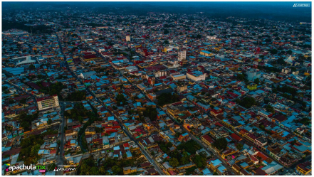
1.Population and Area
Pop: 320,451 (city)
Area: 303 km2
Elev: 177 masl
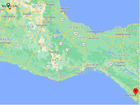
Tapachula location in Mexico within the state of Chiapas
https://goo.gl/maps/ViduNYEVXYpJLFZU7
2. Natural geography
Nature and weather
Flora and fauna
The municipality is characterized by a large extension of mangroves with soil type medium subdeciduous forest and low deciduous forest, including tulares, palm groves and sapote. The mangroves reach the highest recorded heights in the country, being the most representative species: the red mangrove (Rhizophora mangle), yellow mangrove (Rhizophora harrispnii), white mangrove (Laguncularia racemosa), black mangrove (Conocarpus erectus) and mother salt (Avicennia germinans), Zapotón (Pachira aquatic), Zapote chico (Malinkara zapota) and Chico zapote (Achras zapota).
The flora of the municipality is mainly made up of:
Soap, guisquil, zapotón, breadfruit, white, black and red mangrove, bamboo, otate, cedar, guanacastle, spring, liquidábar oak, poor man's layer, tree fern, cypress, pine, romerillo, sabino, chamomile, oak, coyol , cucuunuc, guapinol, morro, palo mulato, quebracho, water hyacinth, mother of salt, water sapote.
The Reserve has a great diversity of habitats for which there is a great variety of species, many of them considered rare, threatened or in danger of extinction. Among the species that stand out, in the most important group of reptiles are: the mazacuata (Boa constrictor); caiman or pululo (caiman crocodilus chiapensis); river crocodile (Crocodylus acutus); riverbank iguana (Iguana iguana); hooded turtle (Kinosternun cruentatum); parlama turtle (Chelonia mydas); leatherback turtle (Dermochelys coriacea); hawksbill turtle (Eretmochlys imbricata); black tortoise (Chelonia agassizi) and gelfian tortoise (Lepidochelyes olivacea). Regarding birds, the most important because they are in danger of extinction are the following: the gallareta (Fulica amercicana); hooked heron (Eudocimus albus); paddle heron (Aiaia aiaia) snail hawk (Rosthramus sociabilis); crabeater eagle (Ruteogallus anthracinus); osprey (Pandion haliaetus) and collajero duck (Anasplatyrhynchos) Mammals include the jaguar, ocelot, young lion, night monkey, spider monkey, white-tailed deer, among others. The main aquatic species are the brown shrimp (Renneos californicus); white shrimp (R vannamei); blue shrimp (R.stylirostri) and red shrimp (R. brevirostris). Among the species of scales, the peje lizard is in extinction. Of the fish, catfish, horse mackerel and snook stand out.
The extension that corresponds to Tapachula within the Ecological Reserve "La Encrucijada" is located in the Cabildos lagoon and its surroundings.
Köppen Classification: Tropical Savanna Climate
ropical savanna climates have monthly mean temperature above 18°C (64°F) in every month of the year and typically a pronounced dry season, with the driest month having precipitation less than 60mm (2.36 in) of precipitation. In essence, a tropical savanna climate tends to either see less rainfall than a tropical monsoon climate or have more pronounced dry seasons than a tropical monsoon climate. Tropical savanna climates are most commonly found in Africa, Asia and South America. The climate is also prevalent in sections of Central America, northern Australia and North America, specifically in sections of Mexico and the state of Florida in the United States.
The Köppen Climate Classification subtype for this climate is "Aw". (Tropical Savanna Climate).
The average temperature for the year in Tapachula is 79.9°F (26.6°C). The warmest month, on average, is April with an average temperature of 82.6°F (28.1°C). The coolest month on average is December, with an average temperature of 77.9°F (25.5°C).
The highest recorded temperature in Tapachula is 103.3°F (39.6°C), which was recorded in May. The lowest recorded temperature in Tapachula is 32.0°F (0°C), which was recorded in January.
The average amount of precipitation for the year in Tapachula is 85.5" (2171.7 mm). The month with the most precipitation on average is September with 17.1" (434.3 mm) of precipitation. The month with the least precipitation on average is February with an average of 0.2" (5.1 mm). In terms of liquid precipitation, there are an average of 145.9 days of rain, with the most rain occurring in September with 23.9 days of rain, and the least rain occurring in January with 0.8 days of rain.
https://www.weatherbase.com/weather/weather-summary.php3?s=40967&cityname=Tapachula%2C+Chiapas%2C+Mexico&units=
Getting there and around
Get there
By air – Tapachula's Tapachula International Airport (IATA: TAP), is located 25-30km south of the city along Hwy 225 (Carretera Tapachula-Pto San Bento) and offers services to all types of flights, private and (limited) commercial. There are daily flights out of the Airport only by:
Aeromexico Connect. Mexico City 3x daily & Guatemala City 1x daily. Additional services to/from Guatemala City and San Salvador is by bus operated by Trans Galgos Inter (written in Spanish).
If the intent of flying here is to transit to Guatemala City or San Salvador, the airfare can be comparable or a wash between flying direct to Central America with Avianca El Salvador (merge with Taca), Interjet, or Ameromexico than landing in Tapachula and going onwards by bus to Central America. Therefore, it can be more economical to just fly from Mexico to Guatemala City then coming through here.
By car – The distance between Mexico City and Tapachula is 886 km. The road distance is 1147.6 km and takes 14h, approximately to get there.
By bus – ADO/OCC buses come from almost everywhere in south/central Mexico. The D.F., Oaxaca, Tuxtla Gutierrez, Puerto Escondido among others.
Tapachula is a good connection point between Guatemala and Mexico with plenty of buses coming from Guatemala city. It can also be reached from Xela, either by taking a chicken bus to Coatepeque (Q18, October 2014) or Reu and another chicken bus or minibus to Tecun Uman (Q7 from Coatepeque), walking across the border and finally taking a collectivo from Ciudad Hidalgo (MX$29) - or take a chicken bus from Xela to San Marcos/San Pedro (Q10), then change to a bus over the very twisty, bumpy mountain road to Malacatan/El Carmen to cross the border into Tapachula itself.
Galgos is now across from the ADO/OCC on 17th, and the office is called "Xytur". But, Galgos still has the wrong address on their website. The buses run at 6:00am and 12:15.
The Linea Dorada runs out of the ADO/OCC at 6:00 am. The new ADO/OCC terminal is located at 17a Oriente y 3a Avenida Norte. If coming from Ciudad Hidalgo (Guatemalan border) in a collectivo (MX$50) you can ask to be dropped here.
From Talisman(Guatemalan border as well) you can catch a collectivo for MX$18 into town. It takes about 30-40 minutes.
When looking for the bus station, it is important to know which line you will be taking. Fortunately collectivos around town are MX $ 10.
https://wikitravel.org/en/Tapachula
https://www.rome2rio.com/s/Mexico-City/Tapachula
Car Rental – To explore Mexico’s provincial towns and cities—including its beach locations and the scenery and attractions near them— consider renting a car for your visit. Having your own car will give you more flexibility than using public transport options and, in some cases, offer you access to places which are otherwise difficult to visit without the use of a car.
COVID19 – International entry into Mexico from United States
Allowed for: All visitors arriving by air. Mexico land borders are closed to non-essential travel
Restricted for: There are no current restrictions.
Get around
Local Buses – Local buses and mini-buses (combis or micros) are available locally for a fraction of the cost of a taxi around town. You need to speak Spanish to be able to ask for directions or ask the driver to tell you where to get off.
Taxis – Taxis in most of Mexico’s towns and cities are not metered, so agree your price before you get in. Taxi travel is very affordable in Mexico, in comparison to the USA, Canada and Europe, and so provides a viable means of public transportation in Mexico. Your hotel can arrange taxis for you; some post their rates on a board in the lobby; taxi hotel rates are usually higher than cabs you hail off the street. If you speak Spanish, you will have a distinct advantage and be able to negotiate a price with the driver.
Uber is expanding rapidly across Mexico and now offers services in cities across the country, including: Mexico City, Toluca, Cuernavaca, Puebla, Querétaro, León, Aguascalientes, San Luis Potosí, Guadalajara, Monterrey, Hermosillo, Tijuana, Mexicali, and Mérida. Uber has been adding Mexican cities to its network every year, check for availability when you arrive at your destination in Mexico.
Cabify and Didi are also developing and currently operate in cities including Mexico City, Toluca, Monterrey, Puebla, Querétaro and Tijuana. Check for availability in the city you are visiting.
These services offer people with smartphones a way to book a cab through a mobile app for a pre-agreed price. Fares are comparable with Sitio type cabs, and sometimes trade at a premium to this when local demand increases.
https://www.mexperience.com/travel/beaches/cancun
3. ECONOMY
GDP: 24,562 M MXN (2010)
https://imco.org.mx/ciudades2010/ciudades/63_Tapachula.html
4. Industry characteristics
The municipality is considered to have a medium level of socioeconomic marginalization. As of 2000, there were 61,444 residences, of which over 72% were the property of the residents. The average household size was 4.36 inhabitants. About one quarter of the homes have dirt floors, thirteen percent have wood floors and about sixty two with cement or stone floors. Walls generally consist of cement block with about fourteen percent having wood walls. About sixty percent of the roofs are made with metal/asbestos laminate.
Tapachula accounts for much of Chiapas' economic activities as the economic center of the Soconusco economic region and as a port for commerce between Mexico and Central America. Hurricane Stan severely damaged the rail line through here connecting Oaxaca and Chiapas with Guatemala, with repairs still ongoing as of 2011. Tapachula is served by commercial airlines using the Tapachula International Airport.
The first Feria Internacional Tapachula was held in 1963 with the name of Primera Gran Exposición Agrícola, Ganadera, Comercial e Industrial del Soconusco. It has been held yearly since then with participants from the region, the state of Chiapas, Mexico and other countries. The purpose of the fair is to promote the products of the region along with its cultural heritage.
About eighteen percent of the working population works in agriculture and livestock. About twenty three percent of these workers are not paid a salary. About sixteen and a half percent work in mining and manufacturing. The municipality is part of a region dedicated to the growing and export of cash crops, especially coffee and tropical fruit. The harvest cycles, along with the usual boom and bust economic cycles associated with such farming has spurred a worker migration pattern which has been studied.
About 63% of the municipality's workforce is in commerce and services, well above the averages for the region and the state. This sector includes tourism. The city's main attractions are in and around its main square called the Parque Miguel Hidalgo, with the rest of attractions located in or near the municipality. Most foreign visitors to the city are from Guatemala, which include those who come to visit the area's beaches. Others mostly consist of those on their way to or from the same country. Despite the area's economic connection with Guatemala, most businesses here do not accept the quetzal for payment. Area attractions within reach of the city and municipality include the Izapa archeological site, El Triunfo Biosphere Reserve, the La Encrucijada Reserve, the Cuilco River cascades and the Tacaná Volcano.
Aside from the city, the other major economic center in the municipality is the new major port of Port Chiapas, with cruise ships beginning to stop here in 2007. This is part of a state and region led effort to attract visitors to area attractions, especially the Coffee Route. This has attracted German and other European visitors to see plantations started by their countrymen over a century ago. Other attractions marketed to cruise ship tourists include the city of Tapachula and the mangrove sanctuaries on the coast. About 45 cruise ships visited the port in 2011.
Key project: Tapachula-Aeropuerto Internacional- Puerto Chiapas train
The Tapachula-International Airport-Puerto Chiapas Train Project of the federal government will have a length of 40.5 kilometers.
The General Directorate of Studies, Statistics and the Mexican Railway Registry of the Railway Transport Regulatory Agency (ARTF) delivered on August 11 the proposal for this new passenger train.
As with the Isthmus of Tehuantepec Train that will use railways of disused concession companies –both will be concessioned– this new work will use the tracks that pass through the Tapachula airport and arrive at the port of Chiapas, currently without service, although They connect with tracks in operation with freight trains.
ARTF plans to put to contest the pre-investment studies between companies in January next year through an injection of 30 million pesos. The full cost of the work was not disclosed.
The information indicates that the initial layout aims to serve four areas in a first stage, with a length of 29.4 kilometers and extending to 40.5 kilometers until reaching Álvaro Obregón, Chiapas, in a second stage.
The work will connect 17 hospitals and 18,100 economic units and, according to the National Population Council (Conapo), it is estimated that by 2030 the number of inhabitants in Tapachula will be greater than 443,000.
Currently, only in the neighborhoods near the train tracks there are 209,960 populations.
In the description of the railway project, the Ministry of Communications and Transportation, through ARTF, indicates that the tracks go through the center of Tapachula, they run towards the airport where they connect with tracks in operation with freight trains.
These roads pass through the airport and reach the Port, currently connecting (but without service) the most important centers of economic development and job creation.
It argues that every day passengers move between these three points; while current transportation systems create problems in the city.
Ecoregional approach
According to the Chiapas State Development Plan 2019-2024, of the state government, "it has not been possible to consolidate development with environmental sustainability, hence the need to implement actions that allow the planning of the territory with an ecoregional approach."
Growth in the region is expected due to different programs for the development of the port and freight transport, which will generate the need for greater mobility in the city.
The preparation of the pre-investment studies will determine the feasibility of implementing a passenger service in the light rail mode, which seeks to use all the current railway infrastructure connecting the city center with two work and mobility points of international importance.
https://www.eluniversal.com.mx/cartera/gobierno-federal-encarrila-proyecto-para-su-tercer-tren
5. Attractions
Historic Center
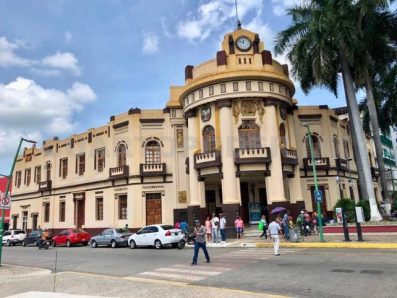
The Historical Center of Tapachula preserves a large part of the history of the Soconusco region.
In Parque Hidalgo (Hidalgo Park) you can relax and enjoy the tranquility of this small and typical Chiapan city, one of its symbols is its thin and tall palm trees that sway to the rhythm of the wind.
Parque Hidalgo is located between the Ex Palacio Municipal (Ex Municipal Palace) that dates from the beginning of the 20th century and the Temple of San Agustín, the most important in the city, which has a chapel where you can find The Last Supper carved in a piece of cedar. This construction dates from 1818.
The temple owes its name to the town's patron saint, who is celebrated in style during Holy Week.
Finca Venecia

The gastronomic richness of Chiapas is one of its main attractions, one of these may also be the rum still produced at Finca Venecia, the only rum producer operating in Mexico.
The fertile soil of the Mexican southeast allowed important sugar mills to be established, so the perfect conditions were given for producing excellent quality rum in estates like this one.
Learn about the history of this farm by walking through its corridors and allow your palate to delight in a tasting of this unique Mexican rum.
Tacaná Volcano
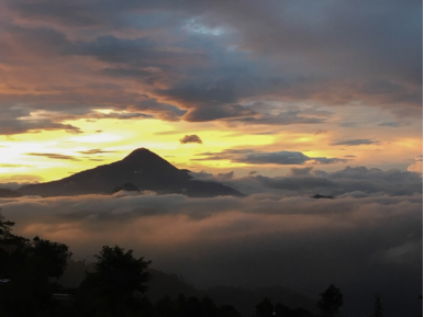
Get to know the highest peak of the Mexican Southeast located between Mexico and Guatemala. Thanks to its high altitude you will be able to distinguish all the different climates and vegetation of the Sierra Madre.
If you are looking for a tour that includes adventure and adrenaline, do not forget to visit the municipality of Union Juarez, this is one of the main destinations for mountain tourism.
In your journey through the area, you will find colorful wooden houses located in the heart of the coffee lands on the slopes of the volcano.
https://www.visitmexico.com/en/chiapas/tapachula
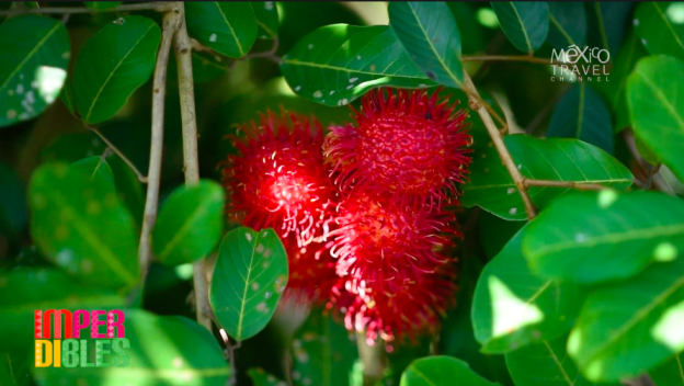
Imperdibles | Tapachula, Chiapas | 2x02
https://youtu.be/hU0VflrPaUo
6. History
The name comes from the Nahuatl phrase “Tapachollan” which means ”between the waters”. The official name of the city was changed to "Tapachula de Córdova y Ordóñez" in 1997 in honor to priest Fray Matías de Córdova y Ordóñez.
The first people to settle in the area migrated from the south in Central America and most likely are the ancestors of today's Mame people. The Olmecs dominated the area, driving many Mames to migrate back south. The Toltecs arrived next but never completely subjugated the native peoples. However, these conquests resulted in the Mames never developing major civilization. The city of Tapachula was founded as a tribute collection center for the Aztecs in 1486 by a military leader named Tiltototl, sent by Ahuziotl to conquer the Soconusco.
The Soconusco region has produced cacao since 2000 BC. After the Spanish conquest, it was administered under the Kingdom of Guatemala. This region was larger than it is today, with the very south of the old extension now part of Guatemala. As such, Tapachula became a border area, first among the Spanish colonial authorities of New Spain, Chiapas and the Captaincy General of Guatemala. For example, when the Diocese of Chiapas was created in 1539, it included the Tapachula area. However, the Soconusco region had political differences with all of these authorities at one time or another. Tapachula became the capital of Soconusco region in 1794, replacing Escuintla. In 1809, shortly before the start of the Mexican War of Independence, Tapachula protested the high rate of taxation to Spanish authorities to no avail. During the war, it was officially declared a town in 1813, and a parish in 1818, with the San Agustín parish church established in 1819. At the end of the war, Tapachula, as capital of the Soconusco, declared its own independence from Spain and Guatemala in 1821, and away from Mexico in 1824. However, for most of the rest of the 19th century, the Soconusco would be disputed territory between Mexico (as part of Chiapas) and Guatemala, until a final border was drawn between the two countries in 1888. In the meantime, Mexican president Antonio López de Santa Anna declared Tapachula a city as he fought to force the region back under Mexican control. The city was occupied by French troops during the French Intervention in Mexico until 1865 when they were expelled by Sebastián Escobar.
The current municipality was created in 1915, with Tapachula as the governing entity. It was declared the provisional capital of Chiapas by forces loyal to Victoriano Huerta in 1924.
The first air route to the city was established in 1929, connecting it with Tuxtla Gutiérrez and Mexico City.
Tapachula became a diocese separate from Chiapas in 1957 covering the entire Chiapas coast area. It was reaffirmed as the capital of the Soconusco region in 1983.
In 1984, a coat of arms was chosen for the city, designed by Edgar José Cabrera Arriaga.
The growth of the city and its economy has presented problems in the early 21st century. The city during this time has grown outward, surrounding industrial structures such as petroleum storage facilities belonging to PEMEX and a terminal of the Chiapas-Mayab railroad. This raised questions of safety until both were moved further outside of the city limits in 2011 (PEMEX is still inside the city, it's never been moved outside of the city).
In September 2019, the Seventh-day Adventist Church in Chiapas unveiled a monument in a ceremony to commemorate the Bible at Los Cerritos Park. Dozens of local government officials, religious leaders, and church members attended the ceremony. The project and the monument were applauded as a community achievement and a historical moment that marks religious freedom. The intent of the project by the church was to recognize the Bible as the guide to the society and to bring awareness to the public in the reading of the Scriptures. The monument was the eighth memorial built by the Seventh-day Adventist Church in Chiapas. Monuments were previously unveiled since 2018 in the following cities: Palenque, Hiuxtla, Malpaso, Pichucalco, Cintalapa, and Usumacinta.
7.Contact Information

City Mayor: Rosa Irene Urbina Castañeda
Contact number: +52 (962) 625 7731
Govt. Office Address: Tapachula, Chiapas, Palacio Municipal S/N, C.P. 30700, Planta Alta
Facebook: https://www.facebook.com/rosairene.urbinacastaneda
Website: https://www.tapachula.gob.mx
