Chetumal, Quintana Roo 作者: 来源: 发布时间:2021-11-16
1.Population and Area
Pop: 151,243 (city)
Area: 18,760 km2 (munip.)
Elev: 10 masl
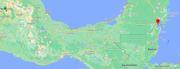
Chetumal location in Mexico within the state of Quintana Roo
https://goo.gl/maps/53VtpR2ybKhjc8NQ7
2. Natural geography
Nature and weather
Orography
As in the entire Yucatan peninsula, the territory of Othón P. Blanco is eminently flat, however, in the territory of the municipality the highest altitudes of the state of Quintana Roo and the peninsula are reached, to the west of the territory on the border with Campeche, is an area of higher altitude, separated from the rest of the territory by a series of steps in the terrain caused by tectonic faults and which is called the Zohlaguna Plateau, it is this region where heights of up to 250 meters above the level are reached. from the sea, such as Cerro El Charro, the highest point in Quintana Roo.
The rest of the municipal territory is made up of the plains that have a gentle slope from west to east, towards the sea, in these areas called lowlands or savannah, large flooded areas called aguadas are frequently formed.
Hydrography
The Municipality of Othón P. Blanco belongs hydrologically speaking to the Eastern Yucatán Hydrological Region (Quintana Roo) and to the Cuenca Cerradas and Bahía de Chetumal basins and others from this same hydrological region.
Although its soil is formed by the same limestone rock of the rest of the peninsula that prevents surface water currents, in Othón P. Blanco there are the only surface waters of the entire territory, which gives a very important characteristic to the territory, Well, there we can find the Río Hondo and the Río Escondido, the only rivers in the entire Yucatán peninsula. The Rio Hondo, which has been marking the international boundary between Mexico and Belize since 1898, has a capital importance in the development of the region, since it was much the only way of communication with the interior of the territory, still today one of the main regions of the municipality is the so-called Rivera del Río Hondo, where there are towns such as Álvaro Obregón, and at the mouth of the same the state capital and municipal seat, Chetumal, was founded. The Río Hondo is born in the border mountains between Belize and Guatemala, most of its course serves as an international boundary and is mostly navigable; For its part, the Escondido River is a current from the neighboring state of Campeche, it is a mostly seasonal river with a very irregular channel, the flat terrain through which it runs allows it to have a wide and slow current, varying its cause according to the Stations, from which its name comes, usually joins wide waterways and lagoons and thus constituted an important communication route, it empties into the Hondo River south of the Bacalar Lagoon, near the town of Juan Sarabia.
In addition, as important as the aforementioned rivers, in the territory of Othón P. Blanco we find a series of lagoons, among which the Laguna de Bacalar stands out, also called the Laguna de los Siete Colores, because it is made up of seven cenotes whose waters overflowed and they constituted the lagoons, it is the largest of the lagoons and the best known of all, it has an approximate extension of 42 kilometers long by only 2 kilometers wide, next to it is the town of Bacalar, the oldest in the municipality There is also the Guerrero Lagoon, communicated through a passage with the Chetumal Bay, the Agua Salada Lagoon, the Chile Verde Lagoon and the San Felipe Lagoon, the combination of rivers, lagoons and intermittent waters that during the rainy seasons arrive practically all being linked by water, they allowed the creation of an important means of communication from the Bay of Chetumal to the interior of the territory that greatly facilitated its development to other parts. It is from the state. Almost next to the Río Hondo and close to Subteniente López and Huay-Pix is Laguna Milagros, smaller than all the previous ones and which constitutes a spa for the inhabitants of the area.
Ecosystems
The vegetation found in the municipality of Othón P. Blanco is mostly medium forest, which extends through most of the interior of the municipality and in it the most representative plant species are the chicozapote, ramón, guayabillo and chacá More isolated areas in the interior of the municipality are populated by high jungle, where you can find the siricote, the dyewood and the mahogany; Towards the southwest of the municipality there are areas dedicated to rain-fed and irrigated agriculture, the main crop being sugar cane, along the coast of the Caribbean Sea you can mainly find mangroves.
The fauna is very rich and varied, among the main species is the manatee, a marine mammal that lives in the bays and lagoons litores and that has become a symbol of the region, you can also find species such as tepezcuintle, wild boar, white-tailed deer, otter, turtles, and birds.
For the protection of animal and plant species there are three ecological reserve zones in Othón P. Blanco: the Uaymil Flora and Fauna Protection Area located on the northeast coast of the territory, near Mahahual; as well as the Manatee Sanctuary in Chetumal Bay and the Banco Chinchorro Biosphere Reserve.
Köppen Classification: Tropical Savanna Climate
Tropical savanna climates have monthly mean temperature above 18°C (64°F) in every month of the year and typically a pronounced dry season, with the driest month having precipitation less than 60mm (2.36 in) of precipitation. In essence, a tropical savanna climate tends to either see less rainfall than a tropical monsoon climate or have more pronounced dry seasons than a tropical monsoon climate. Tropical savanna climates are most commonly found in Africa, Asia and South America. The climate is also prevalent in sections of Central America, northern Australia and North America, specifically in sections of Mexico and the state of Florida in the United States.
The Köppen Climate Classification subtype for this climate is "Aw". (Tropical Savanna Climate).
The average temperature for the year in Chetumal is 79.9°F (26.6°C). The warmest month, on average, is June with an average temperature of 83.5°F (28.6°C). The coolest month on average is January, with an average temperature of 74.1°F (23.4°C).
The highest recorded temperature in Chetumal is 100.8°F (38.2°C), which was recorded in April. The lowest recorded temperature in Chetumal is 42.8°F (6°C), which was recorded in January.
The average amount of precipitation for the year in Chetumal is 52.8" (1341.1 mm). The month with the most precipitation on average is June with 7.7" (195.6 mm) of precipitation. The month with the least precipitation on average is February with an average of 1.1" (27.9 mm). In terms of liquid precipitation, there are an average of 115.3 days of rain, with the most rain occurring in September with 14.4 days of rain, and the least rain occurring in March with 4.0 days of rain.
https://www.weatherbase.com/weather/weather-summary.php3?s=5767&cityname=Chetumal%2C+Quintana+Roo%2C+Mexico&units=
Getting there and around
Get there
By air – Chetumal Airport (IATA: CTM) (ICAO: MMCM) offers a limited selection of flights to major cities in Mexico. It is also possible to fly into airports across the border, in Belize, and cross by land into Chetumal. Another option is to fly into Cancun or Merida and take a bus from the airport.
By car – Mexico's Federal Route 186 traverses the sparsely populated southern half of the Yucatán between Escárcega and Chetumal. After Ucum, the only municipality with services such as gas and lodging between Escárcega and Chetumal is Xpujil. Federal Route 307 branches off Route 186 to the north towards Cancun, from a point about 30 km west of Chetumal.
By bus – Several bus companies offer routes across the Peninsula to Escárcega, or north to Cancun and other cities on the Mayan Riviera. The main bus terminal, i.e. ADO terminal, where most buses arrive to is located about two kilometers north of the city center (in the crossing of Av. Insurgentes and Av. Belice). There's an official taxi stand right outside the terminal, and a taxi to the center costs about 20 pesos.
Taking a Collectivo/Kombi from Tulum should cost you about 40 MXN per person. The ride is short and easy, you will be brought to Chetumal's Downtown, unless you agree with the driver to drop you off somewhere else.
If you're arriving from or departing to Belize, your bus might arrive to the "old ADO station" (la terminal antigua de ADO) on Salvador Novo street near Av. Insurgentes and Av. Belice. Buses no longer stop at the "new market" (Nuevo mercado). The bus fare from Chetumal to Corozal is BZD6 (as of Jan 2015), and BZD 7 to Orange Walk (as of May 2018). Mexican pesos may be accepted, but do the conversion yourself, or the bus conductor might overcharge you.
Warning: When leaving Mexico at the Belize border, you will be charged a fee of $533 Mexican pesos (as of May 2018) UNLESS you can show proof that you paid the immigration fee when you entered Mexico. Your FMM tourist card is not enough. If you crossed at a land border, you'll need the actual receipt from when you paid the fee. If you reached Mexico via a commercial flight, you've may have already paid the fee with your airfare, but the border guards here do not care. You might be able to convince them if you have a print-out of an itemized receipt from the airline showing that this specific fee was included.
https://wikitravel.org/en/Chetumal
Car Rental – To explore Mexico’s provincial towns and cities—including its beach locations and the scenery and attractions near them— consider renting a car for your visit. Having your own car will give you more flexibility than using public transport options and, in some cases, offer you access to places which are otherwise difficult to visit without the use of a car.
COVID19 – International entry into Mexico from United States
Allowed for: All visitors arriving by air. Mexico land borders are closed to non-essential travel
Restricted for: There are no current restrictions.
Get around
Local Buses – Local buses and mini-buses (combis or micros) are available locally for a fraction of the cost of a taxi around town. You need to speak Spanish to be able to ask for directions or ask the driver to tell you where to get off.
Taxis – Taxis in most of Mexico’s towns and cities are not metered, so agree your price before you get in. Taxi travel is very affordable in Mexico, in comparison to the USA, Canada and Europe, and so provides a viable means of public transportation in Mexico. Your hotel can arrange taxis for you; some post their rates on a board in the lobby; taxi hotel rates are usually higher than cabs you hail off the street. If you speak Spanish, you will have a distinct advantage and be able to negotiate a price with the driver.
Uber is expanding rapidly across Mexico and now offers services in cities across the country, including: Mexico City, Toluca, Cuernavaca, Puebla, Querétaro, León, Aguascalientes, San Luis Potosí, Guadalajara, Monterrey, Hermosillo, Tijuana, Mexicali, and Mérida. Uber has been adding Mexican cities to its network every year, check for availability when you arrive at your destination in Mexico.
Cabify and Didi are also developing and currently operate in cities including Mexico City, Toluca, Monterrey, Puebla, Querétaro and Tijuana. Check for availability in the city you are visiting.
These services offer people with smartphones a way to book a cab through a mobile app for a pre-agreed price. Fares are comparable with Sitio type cabs, and sometimes trade at a premium to this when local demand increases.
https://www.mexperience.com/transport/taxi-travel-in-mexico/#51
3. ECONOMY
GDP: 31,469 M MXN (2010)
https://imco.org.mx/ciudades2010/ciudades/86_Chetumal.html
4. Industry characteristics
The municipality is known for the great movement it has in the primary sector, which includes the practice of agriculture and livestock, two basic activities for many of its inhabitants.
It also has wide potential in the tourism field, although the government points out that it is a matter that needs to be exploited more, it is an area that has the benefits of belonging to one of the youngest states and with the most emblematic natural charm that exist in the Republic. Mexican, Quintana Roo.
The relevance of tourism development in the area is great. Othón P. Blanco has emblematic places that are very popular internationally, an aspect that helps to continue exploring other segments related to the tourism sector.
The agriculture practiced in the municipality many years ago focused on the work of the fields of sowing, irrigation and traditional harvest. This sector focuses on the exploitation of the resources that the earth originates, from where its work allows to obtain plant foods such as fruits, cereals, vegetables, forages and much more. All that is obtained is commercialized and a part is for the consumption of the families that practice agriculture, being an adequate way of subsisting through their effort to sow the seeds that later become fruits.
With regard to livestock, it is another preponderant activity because in Othón P. Blanco there are several areas for the practice of this activity. It should be said that according to the natural conditions that exist in the municipality, extensive livestock farming is practiced more because the workers take advantage of natural resources, using little external inputs.
Aquaculture is another relevant activity in the municipality that is known for contemplating activities, techniques and knowledge regarding the raising of aquatic species, animals and plants in fresh or salt water, from which certain foods are produced as raw materials that can be for industrial, pharmaceutical or ornamental use.
The service sector is another aspect that is present in the municipality, it is reflected in everything that is offered in hotels, restaurants, small, medium and large shops, as well as in all those establishments that offer things, from tours, transportation , leisure, culture, finance, entertainment, personal services, food, security, sport and much more.
Manufacturing is another activity that is carried out and is part of the secondary sector, it focuses on the manufacturing process of a product that is made with specialized machinery or by hand. This type of industry is one of the most developed in the state of Quintana Roo, but in the case of the situation that exists in the municipality of Othón P. Blanco, it is carried out focusing on the production of wooden furniture, kitchen instruments, home decor, jewelry and typical elements of the region.
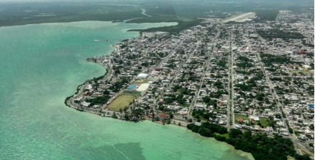
Chetumal is a growing city with an international airport. The city has a Museum of Maya Culture as well as a zoo, the Payo Obispo Zoo, which belongs to the children of Quintana Roo.
Chetumal's economy has been influenced by its proximity to the border with Belize. A goods and services tax-free zone (Corozal Free Zone) established on the Belizean side attracts many visitors to Chetumal and also provides a ready market for Chetumal's retailers and traders. However a certain vacuum was created by the lower free zone prices forcing many Chetumal retailers to close their doors. Merchandise bought elsewhere was hard to sell at higher prices than the competition. Chetumal itself was also once a free zone and a notable destination for people from other parts of Mexico seeking to purchase high-value and bulk goods, free of government duty charges (a policy that was deliberately implemented to attract this business). The city retains a significant retail trade for the region, which supports many local businesses.
Front of the palace of the Governor of the state of Quintana Roo in Chetumal
A large indoor mall, the Plaza de las Américas, houses a modern movie theater (which belongs to the Mexican chain Cinepolis), various department store chains, fast-food outlets, and a Chedraui supermarket.
In addition to its retail economy, Chetumal is also the capital of the state of Quintana Roo. Since it is the location of all of the state's central offices, there is a large population of government employees whose consumption of local goods and services injects additional revenue into the Chetumal economy. As Capital of the state, Chetumal receives a good share of the foreign currencies brought in by the considerable floating population composed of European, Asian and North American tourists.
The city has a music school which offers lessons of various instruments as well as music theory and history. The school is the main music school of the state and is the home of the Junior symphonic orchestra of the state Quintana Roo ("Orquesta sinfonica juvenil del estado de Quintana Roo") which is directed by Silvia Alcantara Chavero.
The city houses two theaters. The "Teatro Minerva", which is an open-air theater and belongs to the state's music school, and the "Teatro Constituyentes", which is a private-owned theater.
There is a Country club, which features tennis, football and basketball courts, a gym, a swimming pool, a steam-bath and a lounge for parties.
In the early 1990s, the University of Quintana Roo was established at Chetumal, providing training and advanced tertiary degrees over a range of subjects.
http://www.municipios.mx/quintana-roo/othon-p-blanco
Key project: expansion of the Chetumal Airport
Achieving that there are more routes and frequencies to the south of Quintana Roo requires the appropriate infrastructure, for this reason we are working on the expansion of the Chetumal Airport, which operates Airports and Auxiliary Services (ASA).
The work is 98% complete, but for now the expansion works are suspended due to the health contingency. The air terminal will add 2,400 square meters to have a total of 3,700. The new Control Tower is also being built, which is 50% complete.
This airport has the capacity to receive flights from abroad, by 2021 it will have its international certification, and they are already working on a plan to incentivize the routes. There the national airlines will play a fundamental role.
https://www.reportelobby.com/2020/08/proyectos-clave-detonaran-turismo-bacalar-chetumal.html
5. Attractions
Chetumal Bay
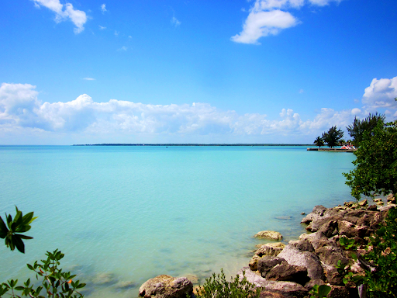
The Bay, located between Mexico and Belize, is a manatee relevant site in the Caribbean.
Such as any coastal town, the bay has a fishing calling ideal for practicing different fishing styles. You can find species such as barracudas, common snook and greater amberjack. Upon arrival, some locals offer their tour services to take you to live the experience.
Water activities are offered since dawn in warm-light Chetumal Bay. Whether by kayak or boat you can go over its 945-square-miles of crystalline water, habitat of many regional plants and animal species. During the tour you will find ancient Maya archaeological ruins which will transport you to a historical vestiges scenario.
The tourist activity extends to Calderitas, the sister fishing village located just 15 minutes away from Chetumal. It’s an ideal place for having an enjoyable-relaxing sunny day on its artificial beaches, tasting the local gastronomy in a wide restaurant offer.
About seven kilometers ahead, you’ll find the Zona Arqueológica de Oxtankah (Oxtankah Archaeological Site), the largest and most important preHispanic city discovered in Chetumal bay. It’s said that in 1937 the archaeologist Alberto Escalona Ramos named it.
The Isla de Tamalcab (Tamalcab Island) is another bay’s nearby visiting place. This uninhabited island is ideal for a fully-day resting.
Dzibanché archaeological site
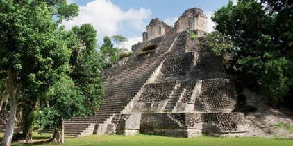
The day dawned sunny, there is good weather to visit and know every part of the Zona Arqueológica Dzibanché, located 80 kilometers from Chetumal. Its establishment dates back to 200 BC.
Dzibanché means in Maya “writing on Wood”. The name refers to the wooden lintels with calendar inscriptions in the structure known as Temple VI.
When you get to the place you can see the buildings which seem proud to stand upright for more than two thousand years. The site occupies an area of about 40 square kilometers (15 square miles) with different complexes.
Its importance is that thanks to it it has been possible to learn more about the Mayan political system, as well as the architectural and urban development that it would have achieved.
Four groups form the tour's first part: Tutil, Lamay, Kinichná and Dzibanché. The complex begins in Edificio VI or Templo de los Dinteles, a building that preserves a base with ornate bodies and a slope and board design.
It continues towards Plaza Gann, an area that preserves a series of diverse-functions-and-periods buildings. It highlights Edificio II or Templo de los Cormoranes, a quadrangular base. Here, you will also find structures 10, 11, 12 and 14, which correspond to residential buildings built during the late Classic period, in addition to Edificio XIII or Templo de los Cautivos.
A few steps away you can see Plaza Xibalba, which was city's downtown.
In the second part of the route you will see Kinicchá, located two kilometers away from the main complex. The Acropolis of this area has several low buildings around it.
Guerrero Lagoon
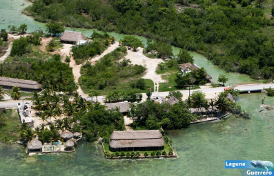
A visit to the Chetumal bay-connected Laguna Guerrero (Guerrero Lagoon), it’s a must. It’s an eight-kilometer strait, surrounded by mangroves where it is possible to observe fauna of the region such as birds, endemic fish, manatees, herons and spatulas, among others.
At the lagoon you’ll find “El Mirador” (a lookout), an over 20 meters height tower ideal for taking pictures of the bay surroundings, resting and eating.
If you want to know more about manatees, we recommend visiting the Centro de Atención y Rehabilitación de Mamíferos Acuáticos del Área Natural Protegida Estatal “Santuario del Manatí-Bahía de Chetumal” (Center for Care and Rehabilitation of Aquatic Mammals of the State Protected Natural Area “Manatee Sanctuary-Chetumal Bay”), a pier-looks-like 20 meter long corral.
Here you can learn more about manatees’ biology, as well as the steps that have been taken to keep these endangered mammals in good condition. Here, you can see specimens of manatees from Belize and the Río Hondo (The deep river) area.
Although it’s a place allocated only for the study and conservation of aquatic mammal species, it is open to the public in order to guide and explain to them how to care for these species.
The site is open from Tuesday to Sunday, from 10: 00 to 17 h. You can get there by car or public transport.
https://www.visitmexico.com/en/quintana-roo/chetumal-grand-costa-maya
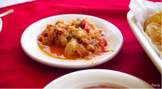
Destination Feature: Chetumal
https://youtu.be/3iqT_sLaFPI
6. History
In Pre-Columbian times, a city called Chactemal (sometimes rendered as "Chetumal" in early European sources), probably today's Santa Rita in Belize, was the capital of a Maya state of the same name that roughly controlled the southern quarter of modern Quintana Roo and the northeast portion of Belize. This original Chetumal is now believed to have been on the other side of the Río Hondo, in modern Belize, not at the site of modern Chetumal.
During the Spanish conquest of Yucatán, the Maya state of Chetumal fought off several Spanish expeditions before finally being subjugated in the late 16th century.
The 1840s revolt of the indigenous Maya peoples against Mexican rule, known as the Caste War of Yucatán, drove all the Hispanic people from this region; many settled in Corozal Town, British Honduras (modern Belize).
The current site of Chetumal was established as a Mexican port town in 1898, originally under the name Payo Obispo. At the invitation of founder Othon P. Blanco, the early town was populated by settlers from Belize (including Caste War refugees and Englishmen).
The name of the town was officially changed to Chetumal in 1936.
Two hurricanes in the 1940s leveled the entire town; Chetumal was devastated a third time in 1955 by Hurricane Janet. After this, the town was rebuilt with more solid construction, with concrete blocks replacing wood as the usual material.
The population of Chetumal was small (about 5,000 in 1950) until the construction of highways linking it to the rest of Mexico in the 1960s and 1970s; the city then boomed with substantial migration from other parts of Mexico.
Foundation
The government of Porfirio Díaz decided to end that situation, resolving to fight the rebel maya and to achieve this it definitively established the boundaries with British Honduras in the Rio Hondo, according to a treaty signed in 1893, also separated the new one from the state of Yucatan Federal Territory of Quintana Roo and sent the army to fight the Maya.
The first step in combating them was to prevent the trafficking of arms from Belize and to assert Mexican sovereignty at that end of the territory, so it was decided to build a fort and customs section at the point where the Hondo River led to the Bahía de Chetumal and who was known as Payo Obispo, an officer of the navy, White P. Mark, suggested that as it was an unexplored place and without any certainty of what the terrain would be like, it would be better to send to the place a than anchored at the point of the bay or the Hondo River, could serve as a barracks and customs section while a permanent establishment was being achieved, and the pontoon would allow for rapid mobility and increased surveillance. Blanco's suggestion was accepted and he was also appointed commandof such pontoon and chief of the operation; the pontoon was built in New Orleans and Blanco gave it the name [Chetumal Ponton], as a souvenir to the Mayan name of the region. He left New Orleans in late 1897 and after making stops in Progress (Yucatan)' Progreso, Yucatan and Cozumel, arrived at the mouth of the Hondo River on 22 January 1898.
Othón P. Blanco quickly organized the garrison and ordered the clearing of the coast, covered with mangrove, to establish a permanent population on the mainland, and also came into contact with Mexicans residing in Corozal Town (Belize)' Corozal and survivors of the Bacalar massacre and communicated their intentions to establish a new population, inviting them to return to Mexico.
Finally, Othón P. Blanco officially founded the new town, on 5 May 1898, with neighbors from Corozal and other parts of the peninsula and gave it the name Payo Obispo', as the region was already known. On the origin of this name it is mentioned that it comes from Fray Payo Enríquez de Rivera, who was Archbishop of Mexico and Viceroy of New Spain, but that when he was Bishop of Guatemala he came to pay a visit to Bacalar, landing at the point that received his name.
Early Years
Payo Obispo was in the beginning a small border town, mainly dedicated to border surveillance and whose economic activities were concentrated on the exploitation of jungle resources such as the Manilkara zapota's chicle, communication with the interior was only by sea, to the port of Vigía Chico, where a railway linked with the capital of the territory, Felipe Carrillo Puerto (Quintana Roo)" Santa Cruz de Bravo, or further north Cozumel or Progress.
The houses were woodland Caribbean English style, as in Belize or Jamaica, built above ground level and painted brightly and with wooden latticework on the windows. Drinking water was collected from the rain through cisterns, of which each house used to have one, although a large public cistern was later built.
Development
The final development of Payo Obispo occurred when the governor of Yucatan, Salvador Alvarado decided to return to the Maya the city of Santa Cruz de Bravo, which at that time belonged to Yucatan after the suppression of the Territory of Quintana Roo and that by being 1915 the capital was moved accordingly to Payo Obispo, thereby increasing population and economic activity, as government units were established in the population.
During the 1920s and 1930s, the exploration and development of Quintana Roo was greatly disseminated, as it was one of the last undeveloped places in the country and many considered it conducive to the establishment of the new models that Advocated the Mexican Revolution, however, on the grounds of financial reasons, the federal government once again abolished the Quintana Roo Territory and divided it between Yucatan and Campeche, with Payo Obispo being left in the latter state, Payo Obispo then led the movement that demanded the restoration of federal territory, a request answered by Lazaro Cardenas del Río, who visited the city in 1934 as a candidate for President and who once had taken office, re-established the territory in 1935.
The new governor, Rafael E. Melgar, greatly promoted the development of the city, he is due the construction of the first concrete buildings, these being the Government Palace, the Morelos Hospital and the Belisario Domínguez School, also developed promoting the establishment of workercooperatives dedicated to logging, rubber and chewing gum, among other products and which motivated the start of emigration to Quintana Roo, promoted in addition to increasing population of the territory. In addition, and according to the postulates of the time, Melgar decided to remove all names of religious origin to the towns and cities of the territory, being renamed Payo Obispo according to decree of 16 February 1937 with the new name of Chetumal.
The development promoted by Melgar declined to a greater or lesser extent during the following governments and for various reasons, but the growth of the city continued to increase, but it was interrupted on 27 September 1955, when the Category 5 Hurricane Janeth struck the city, destroying it almost completely, except for concrete buildings, which were the only survivors and killing around 500 inhabitants. After the hurricane, Chetumal was rebuilt as a modern city, leaving behind its ancient Caribbean appearance.
During the governments of Aarón Merino Fernández, Javier Rojo Gómez and David Gustavo Gutiérrez, the development continued to establish electric light, paving and terrestrial communications, as well as a large emigration from other parts of the country, promoted by the federal government, especially that of Luis Echeverría Alvarez, with the intention of promoting the Federal Territory in state of the Federation, which was finally made on October 8 of 1974, becoming Chetumal in the capital of the new Quintana Roo state.
7.Contact Information
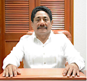
City Mayor: Otoniel Segovia Martínez
Contact number: +52 (983) 835 1500
Govt. Office Address: Av. Alvaro Obregón 321A, Chetumal, Q. Roo.
Facebook: https://www.facebook.com/otoniel.segoviamartinez
Twitter: https://twitter.com/SegoviaOtoniel
Website: http://www.opb.gob.mx/portal
E-mail: presidencia@opb.gob.mx
