Chilpancingo, Guerrero 作者: 来源: 发布时间:2021-11-15
1.Population and Area
Pop: 187,251 (city)
Area: 2,338.4 km2 (munip.)
Elev: 1253 masl
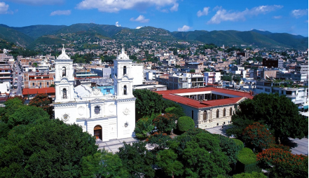
Chilpancingo location in Mexico within the state of Guerrero
https://goo.gl/maps/zsJ4o3DRfYRqM8s37
2. Natural geography
Nature and weather
Hydrography
Chilpancingo has the hydrological resources of the Papagayo rivers; Huacapa, Ocotito, Zoyatepec, Jaleaca and others of less importance; It has two hydrological systems (dams), one in the municipal seat approximately three kilometers away, called Cerrito Rico and the other in the town of Rincón de la Vía.
Flora and fauna
The vegetation is composed of the low deciduous forest with species of mesquite, huizache, hunt, cedar, eucalyptus, jacarandas, whose characteristic is that all or most of the trees throw their leaves in dry weather, there are also pine forests and oak, these are from forest exploitation
Its fauna is varied, we can find species of: chameleon, tigrillo, badger, champolillo, deer, iguana, rabbit, scorpion, eagle, hawk, buzzard, egret, güilota, turtledove, masacuata, coralillo, rattlesnake, field hen, chachalaca, paradise, calandria, cardinal, squirrel, skunk, raccoon, coyote, fox, mouse, opossum, carrot, etc.
Köppen Classification: Tropical Savanna Climate
Tropical savanna climates have monthly mean temperature above 18°C (64°F) in every month of the year and typically a pronounced dry season, with the driest month having precipitation less than 60mm (2.36 in) of precipitation. In essence, a tropical savanna climate tends to either see less rainfall than a tropical monsoon climate or have more pronounced dry seasons than a tropical monsoon climate. Tropical savanna climates are most commonly found in Africa, Asia and South America. The climate is also prevalent in sections of Central America, northern Australia and North America, specifically in sections of Mexico and the state of Florida in the United States.
The Köppen Climate Classification subtype for this climate is "Aw". (Tropical Savanna Climate).
The average temperature for the year in Chilpancingo is 72.1°F (22.3°C). The warmest month, on average, is May with an average temperature of 75.6°F (24.2°C). The coolest month on average is January, with an average temperature of 67.8°F (19.9°C).
The highest recorded temperature in Chilpancingo is 100.4°F (38°C), which was recorded in April. The lowest recorded temperature in Chilpancingo is 35.8°F (2.1°C), which was recorded in February.
The average amount of precipitation for the year in Chilpancingo is 34.4" (873.8 mm). The month with the most precipitation on average is July with 7.8" (198.1 mm) of precipitation. The month with the least precipitation on average is March with an average of 0.2" (5.1 mm). In terms of liquid precipitation, there are an average of 98.6 days of rain, with the most rain occurring in July with 20.7 days of rain, and the least rain occurring in March with 0.8 days of rain.
https://www.weatherbase.com/weather/weather-summary.php3?s=912229&cityname=Chilpancingo%2C+Guerrero%2C+Mexico&units=

Getting there and around
Get there
By air – The closest flight from Mexico City Airport to Chilpancingo is the direct flight to Acapulco which takes 55 min. From there you can take a bus or drive to Chilpancingo.
By car – The distance between Mexico City and Chilpancingo is 212 km. The road distance is 275.2 km. It takes approximately 3h 9m to drive from Mexico City to Chilpancingo.
By bus – The cheapest way to get from Mexico City to Chilpancingo is to bus via Mexico City Taxqueña which costs $240 - $490 and takes 4h 32m, including transfers.
There are services departing from Izazaga and arriving at Chilpancingo via México Central Norte. The journey, including transfers, takes approximately 4h 33m. Mexico City to Chilpancingo bus services, operated by CostaLine, depart from the station.
https://www.rome2rio.com/s/Mexico-City/Chilpancingo-Guerrero-Mexico
Car Rental – To explore Mexico’s provincial towns and cities—including its beach locations and the scenery and attractions near them— consider renting a car for your visit. Having your own car will give you more flexibility than using public transport options and, in some cases, offer you access to places which are otherwise difficult to visit without the use of a car.
COVID19 – International entry into Mexico from United States
Allowed for: All visitors arriving by air. Mexico land borders are closed to non-essential travel
Restricted for: There are no current restrictions.
Get around
Local Buses – Local buses and mini-buses (combis or micros) are available locally for a fraction of the cost of a taxi around town. You need to speak Spanish to be able to ask for directions or ask the driver to tell you where to get off.
Taxis – Taxis in most of Mexico’s towns and cities are not metered, so agree your price before you get in. Taxi travel is very affordable in Mexico, in comparison to the USA, Canada and Europe, and so provides a viable means of public transportation in Mexico. Your hotel can arrange taxis for you; some post their rates on a board in the lobby; taxi hotel rates are usually higher than cabs you hail off the street. If you speak Spanish, you will have a distinct advantage and be able to negotiate a price with the driver.
Uber is expanding rapidly across Mexico and now offers services in cities across the country, including: Mexico City, Toluca, Cuernavaca, Puebla, Querétaro, León, Aguascalientes, San Luis Potosí, Guadalajara, Monterrey, Hermosillo, Tijuana, Mexicali, and Mérida. Uber has been adding Mexican cities to its network every year, check for availability when you arrive at your destination in Mexico.
Cabify and Didi are also developing and currently operate in cities including Mexico City, Toluca, Monterrey, Puebla, Querétaro and Tijuana. Check for availability in the city you are visiting.
These services offer people with smartphones a way to book a cab through a mobile app for a pre-agreed price. Fares are comparable with Sitio type cabs, and sometimes trade at a premium to this when local demand increases.
https://www.mexperience.com/transport/taxi-travel-in-mexico/#51
3. ECONOMY
GDP: 11,530.2 M MXN (2010)
https://dialnet.unirioja.es/descarga/articulo/4954700.pdf
4. Industry characteristics
Main economic activities of the municipality
Primary sector: agriculture, livestock, forestry and fishing
Secondary sector: manufacturing industry, construction, electricity and water
Tertiary sector: commerce, services, transport and communications, tourism, public administration, others.
Tourism
The municipality has enough natural attractions, historical and architectural buildings of all kinds, which attracts many visitors and this represents an important factor in economic development. as to become, in a short time, a destination requested by national and international travelers. The state government has promoted tourism activity in the municipality by implementing and promoting the project called Chilpancingo Azul Tourist Circuit.
5. Attractions
Grutas de Juxtlahuaca (Juxtlahuaca cave system)
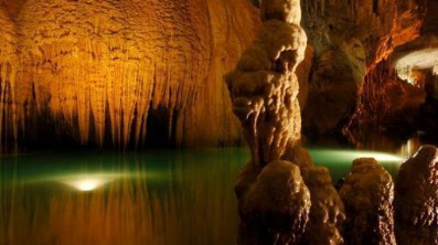
One of Mexican cavers favorite sites is this one—a cave system approximately five kilometers long. Its peculiarity (shared with the Oxtotitlán cave) is that here were found Olmec culture cave paintings, one of the first examples of sophisticated pictorial activity in Mesoamerica and the only example of cave painting in deep caves outside Mayan territory.
52 kilometers away from Chilpancingo, the Juxtlahuaca caves are open to the public but in an official guided tour. The cave paintings are found at about 1,300 meters deep and the most famous is two meters high Pintura 1, that represents a man covered with a jaguar skin, with a black cape and a headdress.
The character has a domination attitude over another, smaller and captured in a sitting posture. It’s one of few representations of Olmec culture showing domination of one man over another. In addition to the cave paintings, these hard access caves present beautifully natural formations.
As the Juxtlahuaca caves couldn’t be associated with any human settlement, they represent a large number of unknowns to researchers.
Tehuacalco Archaeological Site
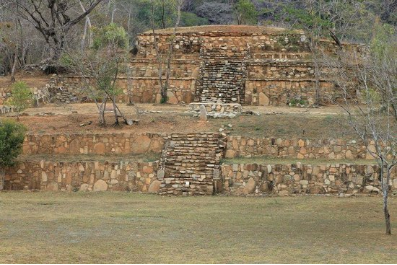
Dedicated to sun, hills and water cult, the Zona Arqueológica de Tehuacalco (archaeological site of Tehuacalco) was first associated with the widely explored Yope culture that was and is one of the few ceremonial centers that Mexicas never dominated.
The site’s name has several ways of interpretation and there is no unanimous agreement, although the most accepted meaning is “Place of the Sacred Water”.
The archaeological zone discovered in 1998 is about 60 kilometers from Chilpancingo and the researchers have restored 11 different constructions, such as Palacio, Templo Principal, the Ball Court and the Conjunto Solar.
The archaeological zone has a small site museum where it is possible to learn about the Yope culture, in addition to its customs related to agriculture and semi-nomadic life.
Colonial Center

The Civic Plaza First Congress of Anáhuac or Civic Square of Chilpancingo, is the main square of Chilpancingo de los Bravo, located in the historic center of the city
With a neoclassical style, the Plaza Cívica houses the former Cathedral of Santa María de la Asunción (St. Mary of the Assumption Cathedral), the building that occupies the Chilpancingo City Hall, the Regional Museum of Guerrero and the Superior Court of Justice. In addition to having a garden in the northern part of the square and a pink quarry kiosk in the center.
The St. Mary of the Assumption Cathedral, also Chilpancingo Cathedral, is the main Catholic temple of the city of Chilpancingo in Mexico, it is consecrated to the virgin Mary in its invocation of St. Mary of the Assumption and for some years it is the episcopal seat of the diocese, since previously this one was in the Leviticus City of Chilapa de Álvarez. It is located in the downtown area, within the architectural and historical complex that occupies the civic Square "First Congress of Anahuac". Its construction is located at the end of the 18th century and beginning of the 19th century.
https://es.wikipedia.org/wiki/Plaza_C%C3%ADvica
https://www.visitmexico.com/en/guerrero/chilpancingo
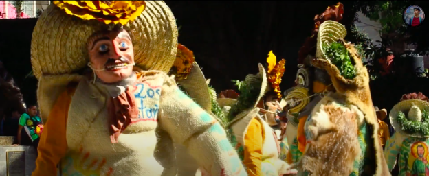
Chilpancingo, Guerrero, cuna de los Sentimientos de la Nación
https://youtu.be/YpA81_kfgLE
6. History
In pre-Columbian times, the area was occupied by the Olmecs, who built an extensive tunnel network through the mountains, and left the cave paintings in the caverns of Juxtlahuaca. The city of Chilpancingo was founded on November 1, 1591, by the Spanish conquistadores, its name meaning “Place of Wasps” in Nahuatl.During the War of Independence, Chilpancingo was crucial to the insurgent cause as its population participated actively and decisively in their favor, and became a strategic point for military action in the south. Chilpancingo was very important to Mexican history because it was here where the National Congress met under José María Morelos y Pavón in 1813 during the Mexican War of Independence.
General Nicolás Catalán, husband of the independence war heroine Antonia Nava de Catalán, was made commander of the state of Guerrero on 24 January 1828. The family settled in Chilpancingo, where both Nicolás and Antonia later died. In 1853, Chilpancingo was declared the provisional capital of the state, due to an epidemic that struck the then capital of Tixtla, and regional ecclesiastical organizational changes were made at the same time. In 1870 it was again declared capital by Governor Francisco O. Arce, due to the opposition led by General Jimenez, who was in possession of the official seat of government at Tixtla. It was not until 1871, when the state legislature agreed to a change of venue, that the capital was moved again from Chilpancingo.
During the Mexican Revolution, Chilpancingo was deeply troubled and had political and administrative importance as a strategic place for the sides in the debate. Battles took place in the vicinity in the 1910s, in which Emiliano Zapata defeated federal forces of Porfirio Diaz, Francisco I. Madero, Victoriano Huerta and Venustiano Carranza. A major defeat of Huerta's southern forces took place here in March April 1914; the Zapatistas took the town until after the Constitutional Convention.
In 1960, the city entered a severe social crisis with the start of a student popular movement at the Autonomous University of Guerrero, protests which led to a general strike at the institution and later swarmed to various forces and social sectors of the city and the state. The main objective was to diminish the power of the state government and seek autonomy for the college. On April 27, 2009 an earthquake with a magnitude of 5.6 was centered near Chilpancingo.
7. Other Information: Congress of Chilpancingo
The Congress of Chilpancingo (Spanish: Congreso de Chilpancingo), also known as the Congress of Anáhuac, was the first, independent congress that replaced the Assembly of Zitácuaro, formally declaring itself independent from the Spanish crown. It was held in Chilpancingo, in what is the modern-day Mexican state of Guerrero, from September 1813 to November 1813. It was here where the first national constitution was ratified. It was composed of representatives of the provinces under his control and charged with considering a political and social program which he outlined in a document entitled Sentimientos de la Nación (Feelings of the Nation) which expressed the sentiment of Creole Nationalism. According to historian D. A. Brading, "Creole patriotism, which began as the articulation of the social identity of American Spaniards, was transmuted into the insurgent ideology of Mexican nationalism."
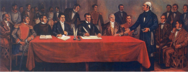
Ignacio López Rayón assumed leadership of Miguel Hidalgo's remaining forces in Saltillo after receiving news of his capture and fled south towards Zitácuaro where he would meet with José María Morelos. Lopez would go on to establish and become President of the Assembly of Zitácuaro along with Morelos. Weak administrative power and losing the battle of Zitácuaro, would lead to the establishment of a new governmental body.
On September 13, 1813, the Congress, with Morelos present, endorsed Mexico's declaration of independence from Spain, established the Catholic religion and drafted a Constitution, creating the legislative, executive and judicial branches of government. The Congress declared respect for property but confiscated the goods of the Spaniards. It abolished slavery and all class and racial social distinctions in favor of the title "American" for all native-born individuals. Torture, monopolies and the system of tributes were also abolished. Morelos was offered the title Generalissimo with the style of address "Your Highness", but he refused these and asked to be called Siervo de la Nación (Servant of the Nation).
After some military defeats, the Congress met again in Apatzingán, and on October 22 promulgated the Decreto Constitucional para la Libertad de la América Mexicana (Constitutional Decree for the Liberty of Mexican America). This established a weak executive and a powerful legislature, the opposite of what Morelos had called for. He nevertheless conceded that it was the best he could hope for under the circumstances.
On November 6, the deputies to the Congress signed the first legal document where the separation of the New Spain with respect to the Spanish rule is proclaimed. The name of this document is Acta Solemne de la Declaración de Independencia de la América Septentrional (Solemn Act of the Declaration of Independence of Northern America).
8.Contact Information

City Mayor: Antonio Gaspar Beltran
Contact number: +52 (747) 472 2057
Govt. Office Address: Plaza Cívica Primer Congreso de Anahuac, s/n, Col. Centro, Chilpancingo de los Bravo, Guerrero, C.P. 39000
FB: https://www.facebook.com/antonio.gasparbeltran.31
Twitter: https://twitter.com/antoniogaspar42
Website: http://chilpancingo.guerrero.gob.mx
E-mail: presidente@chilpancingogro.gob.mx
