Uruapan, Michoacán 作者: 来源: 发布时间:2021-11-15
1.Population and Area
Pop: 315,350 (city)
Area: 954.17 km2 (munip.)
Elev: 1620 masl
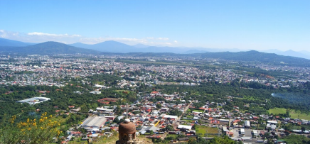
Uruapan location in Mexico within the state of Michoacán
https://goo.gl/maps/jirB3SdV8Danokwj9
2. Natural geography
Nature and weather
Orography and hydrography
The municipality is totally immersed in the Transversal Neovolcanic Axis, so its territory is rugged and mountainous, highlighting the Charanda, La Cruz, Jicalán and Magdalena hills, to the west, and already outside the municipality is the Pico de Tancítaro volcano , the highest elevation in the state. The Municipality of Uruapan is at an altitude above sea level of at least 417.9 meters and a maximum height of 3340 meters above sea level.
The main current of the municipality is the Cupatitzio river, which rises in the territory and flows north to south, there are also the Caltzontzin, Salto Escondido and Cupatitzio reservoirs and a waterfall known as La Tzaráracua. The entire territory of the municipality with the exception of from its westernmost end, it forms part of the Tepalcatepec-Infiernillo River Basin and the western end to the Tepalcatepec River Basin, both form part of the Balsas Hydrological Region.
Flora and fauna
A very important sector of the territory of Uruapan, mainly towards the center and north, is dedicated to agriculture, especially to the planting of avocado. And that is why avocado is called the world capital, which is exported to countries such as the United States, Central and South America, Japan and China, among others. In the rest of the municipality, we find forest, in which in the highest areas there are pine and oak and in the southern part and in the lower part, attached to Tierra Caliente, the flora is very similar to Tierra Caliente, little precipitation and more There is little vegetation that in the North there is no pine, there are only species like parota, guaje, Mezquite, Nopales, cascalote and cirián.
Its fauna includes mainly the coyote, skunk, deer, fox, cacomixtle, hare, opossum, rabbit, duck, torcaza and chachalaca. In the south-central zone we can also find Tierra Caliente species such as the scorpion, Besuconas, Hemidactylus frenatus, armadillo, hawk, rattlesnake, cuiniques, among others.
Köppen Classification: Tropical Savanna Climate
Tropical savanna climates have monthly mean temperature above 18°C (64°F) in every month of the year and typically a pronounced dry season, with the driest month having precipitation less than 60mm (2.36 in) of precipitation. In essence, a tropical savanna climate tends to either see less rainfall than a tropical monsoon climate or have more pronounced dry seasons than a tropical monsoon climate. Tropical savanna climates are most commonly found in Africa, Asia and South America. The climate is also prevalent in sections of Central America, northern Australia and North America, specifically in sections of Mexico and the state of Florida in the United States.
The Köppen Climate Classification subtype for this climate is "Aw". (Tropical Savanna Climate).
The average temperature for the year in Uruapan is 65.5°F (18.6°C). The warmest month, on average, is May with an average temperature of 69.4°F (20.8°C). The coolest month on average is January, with an average temperature of 61.3°F (16.3°C).
The highest recorded temperature in Uruapan is 102.2°F (39°C), which was recorded in April. The lowest recorded temperature in Uruapan is 9.5°F (-12.5°C), which was recorded in December.
The average amount of precipitation for the year in Uruapan is 56.9" (1445.3 mm). The month with the most precipitation on average is July with 12.2" (309.9 mm) of precipitation. The month with the least precipitation on average is February with an average of 0.3" (7.6 mm). In terms of liquid precipitation, there are an average of 108.0 days of rain, with the most rain occurring in August with 24.3 days of rain, and the least rain occurring in April with 0.9 days of rain.
https://www.weatherbase.com/weather/weather-summary.php3?s=916178&cityname=Uruapan%2C+Michoacan%2C+Mexico&units=
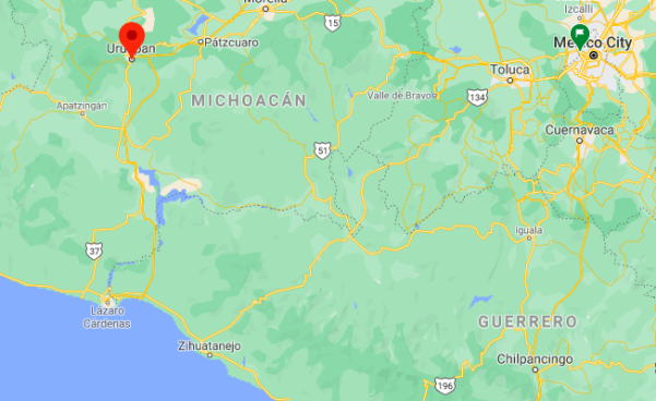
Getting there and around
Get there
By air – The Uruapan International Airport (UPN) aka "General Rayón International Airport" has an elevation of 5,258 ft / 1,603 m. The coordinates are 19°23′48″N and 102°02′21″W.
Round-trip flights from the following cities are available to Uruapan: Chicago, Houston, Las Vegas, Long Beach, Los Angeles, NYC, Orlando, Sacramento, San Diego, San Francisco and San Jose.
You can fly roundtrip from Tijuana to Uruapan on Volaris Airlines for only $373. The Tijuana Airport is next door to the San Diego Airport.
The majority of cross-border travelers who use Tijuana’s Airport are Mexicans and U.S. Latinos. There is a new privately operated cross-border bridge connecting directly to the Mexican terminal with hopes the project will increase American interest in flying out of Tijuana to destinations across Mexico. The cross-border pedestrian bridge connecting to Tijuana's airport is off of Siempre Viva Road on Otay Mesa.
By car – Uruapan is a major crossroads in western Michoacan due in part to the heavy traffic to and from the port city of Lázaro Cárdenas on the Pacific Ocean. You usually have your choice between free roads and toll roads.
By bus – Uruapan Central Bus Station, Carretera Uruapan Patzcuaro, Col. Lomas del Norte Valle
Bus Lines Available: ETN, Autovías, La Línea Plus, Vía Plus, Parhikuni, Primera Plus, Tap, Grupo Estrella Blanca, Omnibus de México, Ruta Paraíso - Galeana - Purépechas, Rumbos Tarascos, Erandi, Autotransportes Tancítaro.
https://wikitravel.org/en/Uruapan
Car Rental – To explore Mexico’s provincial towns and cities—including its beach locations and the scenery and attractions near them— consider renting a car for your visit. Having your own car will give you more flexibility than using public transport options and, in some cases, offer you access to places which are otherwise difficult to visit without the use of a car.
COVID19 – International entry into Mexico from United States
Allowed for: All visitors arriving by air. Mexico land borders are closed to non-essential travel
Restricted for: There are no current restrictions.
Get around
Local Buses – Local buses and mini-buses (combis or micros) are available locally for a fraction of the cost of a taxi around town. You need to speak Spanish to be able to ask for directions or ask the driver to tell you where to get off.
Taxis – Taxis in most of Mexico’s towns and cities are not metered, so agree your price before you get in. Taxi travel is very affordable in Mexico, in comparison to the USA, Canada and Europe, and so provides a viable means of public transportation in Mexico. Your hotel can arrange taxis for you; some post their rates on a board in the lobby; taxi hotel rates are usually higher than cabs you hail off the street. If you speak Spanish, you will have a distinct advantage and be able to negotiate a price with the driver.
Uber is expanding rapidly across Mexico and now offers services in cities across the country, including: Mexico City, Toluca, Cuernavaca, Puebla, Querétaro, León, Aguascalientes, San Luis Potosí, Guadalajara, Monterrey, Hermosillo, Tijuana, Mexicali, and Mérida. Uber has been adding Mexican cities to its network every year, check for availability when you arrive at your destination in Mexico.
Cabify and Didi are also developing and currently operate in cities including Mexico City, Toluca, Monterrey, Puebla, Querétaro and Tijuana. Check for availability in the city you are visiting.
These services offer people with smartphones a way to book a cab through a mobile app for a pre-agreed price. Fares are comparable with Sitio type cabs, and sometimes trade at a premium to this when local demand increases.
https://www.mexperience.com/transport/taxi-travel-in-mexico/#51
3. ECONOMY
GDP: 17,961.8 M MXN (2010)
https://dialnet.unirioja.es/descarga/articulo/4954700.pdf
4. Industry characteristics
The economically active population of the municipality in 2005 was 33.1% and unemployment was 1.27%, people are mainly employed in the tertiary sector (commerce and services), with 82.7% of the total in 2005, followed of the secondary sector with 84.56%. The average income of the municipality in HIGH salaries is 7.9.
The main agricultural activity in the municipality of Uruapan is undoubtedly the cultivation of avocado, which has been called the green gold of Michoacán. The great boom in avocado production in the state began in 1997, this was the year where the ban on exporting Mexican avocados to the United States was suspended by decree imposed since 1913.2016 As of 1997 2016 the municipality has Avocado exported to the United States, this being the largest consumer of Uruguayan production, reaching 200 thousand tons out of a total of 300 thousand tons exported abroad.
Without ceasing to add importance, some of the agricultural activities of the municipality are; the cultivation of sugar cane, corn, peaches, coffee, guava and vegetables such as tomato, chili and pumpkin. Livestock activity is important, in addition, cattle, pigs, goats, horses, poultry are raised and there is a small forestry sector.
Industrial activity is not very developed, although there are companies dedicated to the manufacture of plastics, paper manufacturing, chocolate-based products and avocado packaging.
The commerce and services sector is integrated by the activity of hotels and restaurants in the city, as well as shopping centers, among which are large international and national chains.
Key project: improvement of water infrastructure for Uruapan
With a tripartite investment from the federation, the State and the Uruapan City Council for more than 13 million pesos, the Government of Michoacán, through the State Commission for Water and Watershed Management (CEAC), signed a coordination agreement with the municipality for the execution of three hydraulic works during this year.
The next water infrastructure to be carried out in Uruapan refers to the drilling of a deep well in the Plutarco Elías Calles neighborhood, in the town of Toreo El Alto, which will be carried out with resources of 2,800,000 pesos from the Drinking Water, Drainage and Treatment, in the Urban Section (APAUR) of the state government.
Also, a rain collector will be built in the first stage, which will cover various neighborhoods in the eastern part of the municipality.
This project includes an investment of 8 million pesos contributed by the three levels of government and will mean an important change in their daily lives for the inhabitants of this area, since they will no longer suffer the ravages of the floods that occur year after year in the rainy season.
Finally, the supply and installation of micrometers for household outlets will be carried out, with the application of 2 million 694 thousand pesos from the Uruapan City Council and the Potable Water, Drainage and Treatment Program of the state government.
https://www.altorre.com/post/anuncia-gobierno-de-michoac%C3%A1n-inversi%C3%B3n-h%C3%ADdrica-para-uruapan
5. Attractions
Paricutín Volcano
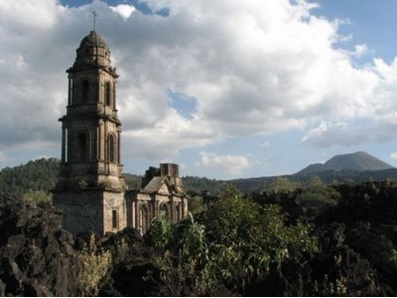
Can you imagine one day walking in peace when suddenly the earth not only starts to shake, but also opens up before your eyes and starts to steam and throw stones? That is what happened to a farmer who saw the birth of one of the most “recent” whims of Uruapan: the Paricutin volcano that warned the world that it was coming to stay on February 20, 1940, making it the youngest volcano in the world.
28 kilometers ( 17 miles ) west of Uruapan, this natural wonder attracts locals and strangers who like to climb it to admire the impressive views that the Paricutin jealously guards. Another pastime is to explore its surroundings formed by the vestiges of the towns that were left under the lava.
The first town was left with nothing in sight, since that is where the crater emerged. Of the second, the curious visitors to the volcano are still amazed by the tower, apse and altar of the San Juan church that stood before the lava as the last witness to this event. If walking is not your thing, you can hire a horse ride that will take you directly to the ruins of San Juan Parangaricutiro.
La Huatápera, Museum of Indigenous Art and Tradition
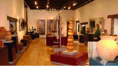
Among the many curiosities that make Uruapan unique, is that thanks to its Purepecha heritage, the tradition of craftsmanship has been maintained. For example, the beautiful black lacquers, golden borders and beautiful colors in objects as diverse as bateas, jícaras, masks or wooden boxes have made the world turn to see them, earning them the nickname “ la cuna del maque” (the cradle of the maque).
It is this richness in different artisan techniques that led the municipality to inaugurate a museum dedicated to them. Heading to the Plaza de Morelos, in the downtown area, you will find the Huatapera (” Lugar de Reunión” in Spanish) (“Meeting Place” in Spanish), whose building dates back to 1533 when it was ordered to be built to serve as a hospital, but which is currently the home of the Museo de Arte y Tradición Indígena (Museum of Indigenous Art and Tradition).
The site has four rooms specialized in different themes. The first one, “ Los cuatro pueblos” (“The four towns”), focuses on the surrounding towns, detailing their daily life by means of recreational, artistic and religious objects. The tour continues through “El Maque de Michoacán”, dedicated to highlighting Purepecha art as well as helping the visitor to differentiate the variants among them by means of their aesthetics and the tools used to elaborate them in three different regions: Uruapan, Quiroga and Pátzcuaro, each one as different as the previous one, being noticed in their finishes and designs.
The last two rooms are for temporary exhibitions on the theme of indigenous life, whether it is their idiosyncrasies, traditions, customs, beliefs or life.
Do not forget to visit the chapel whose facade is adorned by an arch decorated with reliefs made by indigenous people, also inside it houses an incredible mural from the 16th century.
Parque Nacional Barranca de Cupatitzio
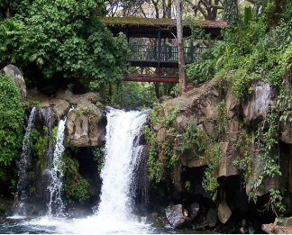
As you go into Parque Nacional de Cupatitzio (Cupatitzio National Park), now a protected area, it is very possible that you will find yourself facing some kind of salamander, frog or toad hiding among the moss or some birds that are its distinguished inhabitants.
This park is extremely popular as it is one of the few natural lungs in the city, so families usually gather to clear their heads a bit by breathing fresh air and getting physically active in the children's areas and their tracks to walk or run through this beautiful scenery.
If you are looking for less hectic activities, you can take advantage of the sale of handicrafts or typical food that is given in the place, how about tasting a freshly caught trout in the waters of its hatchery?
Only surrounded by nature will visitors understand the great importance of this biological corridor that emerges in the Pico de Tancítaro to take over the forest area of Uruapan.
Barranca de Cupatitzio is beautiful and it is also where different activities are carried out for its protection, because this is where the aquifers that feed the river from which the park takes its name are recharged and which is vital for the development of Uruapan, since it is the one that supplies the city with drinking water.
https://www.visitmexico.com/en/guanajuato/irapuato
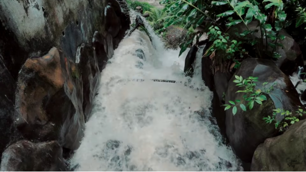
Irapuato 2019 | La Capital Mundial de las Fresas
https://youtu.be/pt3AdDDQudU
6. History
Designation
The name comes from the Purépecha word uruapani which means plants that flower and fruit at the same time or those which are always giving fruit. The coat of arms was designed by Luis Valencia Madrigal and represents the history of the area since the pre Hispanic period as well as its natural resources.
Pre Hispanic history
Uruapan was a pre-Hispanic settlement, inhabited primarily by Purépechas. Much of the history is unknown with numerous unexcavated archeological sites. The oldest document about the area is the Lienzo de Jucutacato, found in the community of Jicalán. It is known that the area was conquered in 1400 by an alliance of the lords of Pátzcuaro, Tzintzuntzan and Ihuatzio.
Colonial era
When the Spanish invaded the Purépecha Empire, the last ruler fled to Uruapan, leading the Spanish here in 1522. For this reason the Spanish arrived here in 1522. In 1524, the area became an encomienda under Francisco de Villegas and evangelized by the Franciscans.
Franciscan friar Juan de San Miguel is considered the founder of the modern city, tracing it out in 1534 into nine neighborhoods, each with its own chapel and patron saint, and assigned who would live in each one. In 1540 the area became an Indian Republic.
During the colonial period, the city was a strategic location, especially for commerce, between the Purépecha highlands and the Tierra Caliente leading down to the coast.
In 1577 a plague decimated the population.
By 1754, the parish of Uruapan consisted of the city of Uruapan, three towns (San Francisco Xicalán, San Francisco Jucutacato and San Lorenzo) along with two ranches Tiamba and San Marcos along with the Carasa Hacienda. The population was a mix of Purépecha, European, African and mixed races peoples.
In 1766, the population revolted against efforts by the Spanish to recruit the population into military service. This was followed by repression and punishment of various persons by execution in 1767, both for the resistance of the prior year and protests against the expulsion of the Jesuits.
From 1795 to 1798, insurgent José María Morelos lived here. During the war, the city served as a refuge various times for insurgents, include local José María Izazaga.
19th century
In 1806, an earthquake destroyed the hospital, and in 1817, the city was burned.
Uruapan officially became a municipality in 1831. For its role in the War of Independence, it was named a Ciuda del Progreso (City of Progress) in 1858.
In 1842, the city supported the rule of Antonio López de Santa Anna.
Because of the French Intervention, the Uruapan was the temporary capital of Michoacan from 1863 to 1867. In 1864, French troops entered and subdued the city. In 1865, General José María Arteaga, head of the Republican Army and four other officers were executed by firing squad, and are known as the Martyrs of Uruapan. In 1866 the Republicans tried to liberate the city from the French at the Battle of Magdalena but were defeated.
The first textile factory was set up in the city in 1874, and the first local newspaper, El Precursor Uruapense was founded in 1880. The first railroad line reached the city in 1899, and a trolley line was built between the rail station and the main plaza in 1900.
20th and 21st centuries
In 1910, a fire destroyed several factories in the city.
The city was attacked several times during the Mexican Revolution, the most notable of which were led by Joaquín Amaro. In the 1930s, efforts to redistribute agricultural land began.
In 1947, the Tepalcatepec Commission was created which modernized the area's economy as well as infrastructure.
Since the late 20th century, the city has had problems with organized crime, along with much of the rest of the state. Two criminal organizations, Los Zetas and La Familia Michoacana, have fought for control here, because of its geographic location among drug routes. In 2014, the city was taken over briefly by the Grupos de Autodefensa Comunitaria or "autodefensas", an armed civilian movement trying to counter the power of the cartels, unsupported by the local and state government. In August 2019, 19 people were murdered by the Jalisco New Generation Cartel.
7.Contact Information

City Mayor: Miguel Ángel Paredes Melgoza (interim)
Contact number: +52 (452) 524 0092
Govt. Office Address: Av. Chiapas No. 514, Col. Ramón Farías
FB: https://www.facebook.com/MiguelParedesMelgoza1
Website: https://uruapan.gob.mx
E-mail: sria.particular.upn@gamil.com
