Poza Rica, Veracruz 作者: 来源: 发布时间:2021-11-15
1.Population and Area
Pop: 200,119
Area: 111.03 km2
Elev: 64 masl
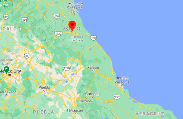
Poza Rica location in Mexico within the state of Veracruz
https://goo.gl/maps/DGnveWR89DQtACKX9
2. Natural geography
Geography
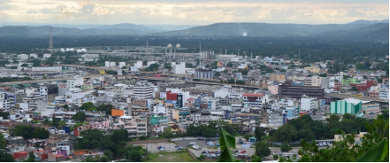
The center of the city sits in a small valley above the Cazones river basin, on the coastal plain of the Gulf of Mexico, with an average altitude of 60 meters above sea level, although most of the territory sits on irregular soils, mostly part of the hills to the northeast of the city, among which the Cerro del Mesón stands out, with a maximum height of 242 meters above sea level. The predominant soils are of the vertisol type, with a high content of expansive clays that form cracks in dry seasons.
From its beginnings, the accelerated urban growth exceeded in extension the capacity of the flat land available in the city, expanding the urban area towards the northeast of the municipality, making more and more use of irregular soils and hills that border the municipality of Papantla. inhabiting the slopes of the hills that surround the center of the city.
Hydrography
The municipality of Poza Rica is located in the hydrographic basin of the Cazones River; This 100 km long river is born in the mountainous region of the state of Hidalgo and empties into the Gulf of Mexico. It has an average annual runoff of 40 m³ / s at its mouth. The city is also surrounded by several tributary streams of the Cazones river such as the Mollejón, Hueleque, Salsipuedes and Arroyo del Maíz, which are regularly affected by floods in the annual rainy season.
Nature and weather
It dominates the medium evergreen forest with species of guarambo, jonote, guanactle and sangrado, where a fauna composed of populations of rabbits, raccoon armadillos, opossums, badgers and coyotes develop.
Köppen Classification: Tropical Monsoon Climate
Tropical monsoon climate, occasionally also known as a tropical wet climate or tropical monsoon and trade-wind littoral climate in climate classification, is a relatively rare type of climate. Tropical monsoon climates have monthly mean temperatures above 18°C (64°F) in every month of the year and feature wet and dry seasons, as Tropical savanna climates do. Unlike tropical savanna climates however, a tropical monsoon climate's driest month sees less than 60 mm (2.36 in) of precipitation. Also a tropical monsoon climate tends to see less variance in temperatures during the course of the year than a tropical savanna climate. This climate has a driest month which nearly always occurs at or soon after the "winter" solstice for that side of the equator.
The Köppen Climate Classification subtype for this climate is "Am". (Tropical Monsoon Climate).
The average temperature for the year in Poza Rica de Hidalgo is 77.0°F (25°C). The warmest month, on average, is June with an average temperature of 84.2°F (29°C). The coolest month on average is January, with an average temperature of 66.7°F (19.3°C).
The highest recorded temperature in Poza Rica de Hidalgo is 116.6°F (47°C), which was recorded in April. The lowest recorded temperature in Poza Rica de Hidalgo is 31.1°F (-0.5°C), which was recorded in December.
The average amount of precipitation for the year in Poza Rica de Hidalgo is 44.6" (1132.8 mm). The month with the most precipitation on average is September with 8.8" (223.5 mm) of precipitation. The month with the least precipitation on average is March with an average of 1.3" (33 mm). In terms of liquid precipitation, there are an average of 104.4 days of rain, with the most rain occurring in September with 11.9 days of rain, and the least rain occurring in May with 5.6 days of rain.
https://www.weatherbase.com/weather/weather-summary.php3?s=58667&cityname=Puebla%2C+Puebla%2C+Mexico&units=
Getting there and around
Get there
By air – The quickest way to get from Mexico City to Poza Rica is to fly which costs $1500 - $3400 and takes 2h 27m. The quickest flight from Mexico City Airport to Poza Rica Airport (El Tajin National Airport) is the direct flight which takes 55 min and costs around the same.
By car – To drive to Cholula from Mexico City, take Highway 150D South, or from Veracruz, 150D west. From Puebla, follow the signs to the Cholula, which is situated about six miles west of the city of Puebla.
By bus – There are services departing from Izazaga and arriving at Poza Rica de Hidalgo via México Central Norte. The journey, including transfers, takes approximately 4h 41m, including boarding and transfers.
https://www.rome2rio.com/s/Mexico-City/Poza-Rica
Car Rental – To explore Mexico’s provincial towns and cities—including its beach locations and the scenery and attractions near them— consider renting a car for your visit. Having your own car will give you more flexibility than using public transport options and, in some cases, offer you access to places which are otherwise difficult to visit without the use of a car.
COVID19 – International entry into Mexico from United States
Allowed for: All visitors arriving by air. Mexico land borders are closed to non-essential travel
Restricted for: There are no current restrictions.
Get around
Local Buses – Local buses and mini-buses (combis or micros) are available locally for a fraction of the cost of a taxi around town. You need to speak Spanish to be able to ask for directions or ask the driver to tell you where to get off.
Taxis – Taxis in most of Mexico’s towns and cities are not metered, so agree your price before you get in. Taxi travel is very affordable in Mexico, in comparison to the USA, Canada and Europe, and so provides a viable means of public transportation in Mexico. Your hotel can arrange taxis for you; some post their rates on a board in the lobby; taxi hotel rates are usually higher than cabs you hail off the street. If you speak Spanish, you will have a distinct advantage and be able to negotiate a price with the driver.
Uber is expanding rapidly across Mexico and now offers services in cities across the country, including: Mexico City, Toluca, Cuernavaca, Puebla, Querétaro, León, Aguascalientes, San Luis Potosí, Guadalajara, Monterrey, Hermosillo, Tijuana, Mexicali, and Mérida. Uber has been adding Mexican cities to its network every year, check for availability when you arrive at your destination in Mexico.
Cabify and Didi are also developing and currently operate in cities including Mexico City, Toluca, Monterrey, Puebla, Querétaro and Tijuana. Check for availability in the city you are visiting.
These services offer people with smartphones a way to book a cab through a mobile app for a pre-agreed price. Fares are comparable with Sitio type cabs, and sometimes trade at a premium to this when local demand increases.
https://www.mexperience.com/transport/taxi-travel-in-mexico/#51
3. ECONOMY
GDP: 16 255.4 M MXN (2010)
https://www.researchgate.net/publication/323024280_El_producto_interno_bruto_de_los_municipios_de_Mexico_II_Estados_M-Z
4. Industry characteristics
The economy is driven by commerce, the Oil industry, fashion, and tourism. What has brought with it a boom in commercial matters, which together with its strategic location and concentration of services, causes a daily flow of residents of other localities, municipalities and nearby cities such as Papantla, Gutiérrez Zamora, Tecolutla, Martínez de la Torre and TihuatlánCoatzintla in the state of Veracruz, extending its area of influence over localities and populations of the neighboring State of Puebla, which converge to it for different reasons, among which are health, employment, education or shopping, since in it they are located the largest supply, trade and service centers.
Oil industry
Poza Rica is a city whose subsoil contains extreme amounts of oil, corresponding to its exploration and exploitation by the parastatal company Petroleos Mexicanos (PEMEX). Poza Rica is considered within the "North Region" in the organization and oil production. According to the official figures provided by PEMEX, of the 2 million, 547 thousand barrels per day of oil extracted throughout the Mexican Republic, 68 thousand barrels correspond to Poza Rica-Altamira.
The Poza Rica oil fields are considered mature but a problem is the burners since they emit toxic gases and the people who live nearby report 4 to 6 cases of poisoning and death from the same, so it is visualized that it will be necessary to the application of current technologies, in order to preserve the exploitation of oil for the coming years.
Due to this, PEMEX presented to the National Hydrocarbons Commission, the oil exploitation project aims to achieve a production of 166.2 million barrels (mmb) of oil and 203.2 billion cubic feet (mmmpc) of gas, with a cost of 42,056 million pesos during the period from 2011 to 2025. The scope of this project is to acquire 1,130 km² of seismic, the drilling and completion of 121 wells, as well as the realization of 262 major repairs. The optimization and / or divestiture of facilities, as well as the transport and handling of hydrocarbons, of 246 km of oil and gas pipelines are also projected.
The investment to be made, estimated by the National Hydrocarbons Commission, will be 20,652 million pesos, with an expectation of receiving 173,574 million pesos.
5. Attractions
Colonial Center
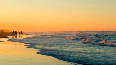
It must be said: Poza Rica doesn’t have a beach. However, the closest one is just 20 minutes away: Barra de Cazones beach, where the same name river and the Gulf of Mexico meet. Here’s a fishing village; locals offer tours to snorkel or dive in the reef.
At the foot of the beach, there are enramadas to eat ceviche and zacahuil tamal made with beef, pork and chicken bathed in red chili sauce. Hammocks and lounge chairs are also rented. In October, all tourists are invited to participate in the release of hawksbill, olive ridley, white and green turtles.
At the mouth of the river there are boat rides to enter the mangroves and observe birds from Canada and the United States.
Cristo Redentor
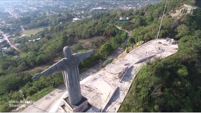
Tihuatlán valley is 20 kilometers from Poza Rica and is a mandatory stop to buy hand-carved crafts and climb the Cristo Redentor, sculpted in the likeness of the one on Corcovado hill in Rio de Janeiro, Brazil.
The Christ, with open arms as a sign of blessing, is Mexico’s third tallest sculpture, only after the Tuxtla Gutiérrez’ Cristo de Copoya, and Janitzio’s monument to José María Morelos. It is 35 meters high and was built to attract religious tourism to Veracruz northern region.
The base that supports it was decorated with bas-reliefs representing Saint Francis of Assisi (town’s saint patron), dancers, flowers, clouds, angels and a cross. The Papantla-born muralist Teodoro Cano was in charge of design.
Park of the Americas
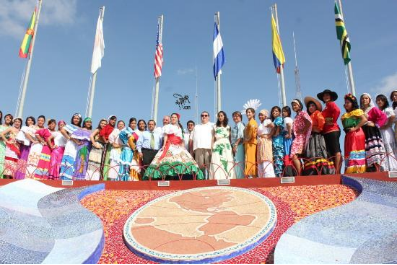
Several stairs lead to the top of Cerro Abuelo, an old hill that was used to plant sugarcane and coffee. It was also a refuge for workers to hold union meetings in the early 20th century.
At the end of the 1950s, the local government decided that it was a good place for people to enjoy the view, which spread all over Poza Rica and Tihuatlán and Coatzintla neighboring municipalities. Then, the construction of actually Parque de las Américas began, inaugurated on September 16, 1957.
The place consists of a 100 meters above sea level viewpoint that commemorates the union among American continent countries. To do this, 20 flags placed in circumference are waved. The one in Mexico is on a 40 meter high mast.

POZA RICA. PARADOR TURÍSTICO.
https://youtu.be/KoIGwdiT_FI
6. History
The territory that currently covers the municipality of Poza Rica has been inhabited, approximately, since the year 800 of our era. The ancient inhabitants left signs of their passage through these places that in May 2011 they were discovered in the old common of El Arroyo del Maíz.
So far the data of what happened to Poza Rica during the colony and the conquest are not very clear, but according to old documents by 1871 it was already inhabited and was already recognized as Poza Rica, at that time it was a Totonac indigenous community, belonging to the municipality of Coatzintla. The inhabitants of Poza Rica dedicated themselves to the cultivation of their lands and enjoyed the abundant fishing of the Cazones River and the streams.
From that time comes the name of Poza Rica because it is said that in the backwater that gives its name to the city there were a large number of fish.
In 1896 the inhabitants of Poza Rica and Poza de Cuero - currently the Manuel Ávila Camacho colony - received, from the municipal government of Coatzintla, the property titles to their lands.
Years later, oil deposits were discovered in the Coatzintla municipality, specifically in the Furbero community, the Oild Fields Mexico Company extracted large amounts of oil and also installed an oil field in the community of Palma Sola.
At the beginning of the 20th century, the narrow railway line was built that covered the route from the port of Cobos in Tuxpan, to Furbero in Coatzintla, that road passed through the community of Poza de Cuero- where the Garibaldi square is currently located- and It also crossed through Poza Rica, which was also known as kilometer 56.
Years later, the Mexican company de Petróleo El Águila bought its facilities from the Oild Fields México Company and discovered in 1930 the Poza Rica Number Two well, which is located in the current Colonia División de Oriente. That well was so rich that the company decided to close its field in Palma Sola and bring it to Poza Rica in December 1932.
Thus, on board the Cobos - Furbero machine, the workers and their families arrived in Poza Rica to make the ranchería grow. From that moment on, the quiet indigenous community will begin to populate with people from all over Mexico and even the world attracted by the immense wealth of the subsoil of Pozarrica, and this place will become the most important oil exploitation center in Mexico. .
The companies exploited and mistreated oil workers, so many of them secretly began to form a union that would first be recognized by section 1 of the Aguila Union based in Ciudad Madero, Tamaulipas and later would be integrated into the national union as section 30.
During 1937 the workers demanded higher benefits and wages but El Águila refused to pay them, so they went on strike for 57 days. As the inhabitants of Poza Rica depended directly or indirectly on the oil industry, they all expressed solidarity with the workers, creating for the first time a sense of belonging in the perolero field. That same year, a group of oil workers met with Lázaro Cárdenas to propose the expropriation of the Poza Rica field.
The president listened to them but asked for calm, because at that moment the Mexican authorities were about to decide whether to force the companies to pay more benefits to the workers. On March 18, 1938, Cárdenas decreed the expropriation of the assets of foreign oil companies.
In Poza Rica, the workers were in charge of receiving the oil installations. It is said that one of the English bosses told one of the workers that he would give him the keys but to take good care of them because soon the foreigners would return for what they considered theirs. For the following years Poza Rica grew in population, in the forties it was known as The Oil Capital of Mexico.
Accidents in the oil industry were always very relevant due to the risks they implied for the population. In September 1947, the Poza Rica 6 well, which is located in the current Anáhuac neighborhood, caught fire and after several days of fighting the flames, finally on September 22, the oil worker Adolfo Rendón managed to control the fire that left enormous losses to the oil industry. The federal authorities, as a tribute to his heroism, offered Rendón all kinds of rewards for putting out the fire, however he only asked for a school for his community, the current Petromex colony. This is how the current Benito Juárez elementary school was built.
1950 was a decisive year in the history of Poza Rica since on September 4, in the Congregation Poza de Cuero- km 52, current Manuel Ávila Camacho neighborhood, a fire broke out that destroyed a large part of the commercial area of that town . The victims went to the Coatzintla Municipal Palace to request support to reactivate their businesses, but the aid was denied, this led the residents of Poza de Cuero to organize and request their separation from Coatzintla. On September 22, in Poza de Cuero, the pro-people committee is formed, headed by Agustín Rubio Zataray; and on the 28th of that month they requested the creation of the municipality of Poza Rica.
On November 24 of that year, the hydrogen sulfide gas burner of the Department of "Natural Gas Utilization Treatment" was turned off, which generated air pollution and caused the poisoning, with hydrogen sulfide, of 25 people who died at dawn of that day.
By 1951 the inhabitants of Poza Rica and Poza de Cuero had obtained the adhesion of the neighbors of Petromex, together they achieved that the legislature of the state of Veracruz created on November 13, 1951 the free municipality of Poza Rica de Hidalgo Veracruz. On November 20, 1951, the new municipality was installed that would be governed by a municipal council made up of Francisco Lira Lara, as president, Raúl Crespo Rivera, Palemón Vázquez, Agustín Rubio Zataray, Adolfo Rendón Rendón, Raymundo Villegas and Edmundo Cárdenas, as members. .
7.Contact Information

City Mayor: Francisco Javier Velázquez Vallejo
Contact number: +52 (782) 826 3400
Govt. Office Address: Josefa Ortiz de Dominguez S/N, Obras Sociales, 93240 Poza Rica de Hidalgo, Ver.
FB: https://www.facebook.com/Francisco-Javier-Vel%C3%A1zquez-Vallejo-744698372393912
Website: https://www.gobiernodepozarica.gob.mx
