Cholula, Puebla 作者: 来源: 发布时间:2021-11-15
1.Population and Area
Pop: 118,170 (city)
Area: 111.03 km2
Elev: 2,150 masl
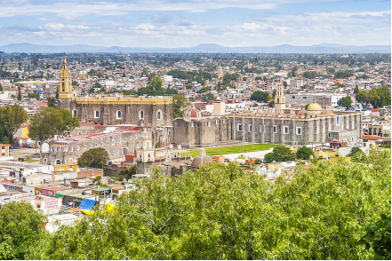
Atlixco location in Mexico within the state of Puebla
https://goo.gl/maps/Rs2aQCvP98Wy4kes5
2. Natural geography
Geography
The city of Cholula is located just west of the state capital of Puebla and is part of its metropolitan area. The city is divided into two municipalities, called San Pedro Cholula and San Andrés Cholula, which also include a number of smaller communities that surround the city proper. The main plaza of the city is located in the municipality of San Pedro Cholula, but the Great Pyramid, located only a few blocks away, is located in San Andrés Cholula. Of the two sub-divisions, San Andrés is more residential and has the higher indigenous population. The city as a whole is officially called the Distrito Cholula de Rivadavia. It was created in 1895 and named in honor of Bernardino de Rivadavia.
Nature and weather
The Neartic fauna can be divided into two large groups, the first that currently lives in the upper parts of Popocatepetll and Iztazihuatl, in the pine and oyamel forests and are characterized by the following species:
Köppen Classification: Oceanic Subtropical Highland Climate
Cholula is part of Puebla City metropolitan area, so its shares the characteristics of its climate.
The subtropical highland variety of the oceanic climate exists in elevated portions of the world that are within either the tropics or subtropics, though it is typically found in mountainous locations in some tropical countries. Despite the latitude, the higher altitudes of these regions mean that the climate tends to share characteristics with oceanic climates, though it also tends to experience noticeably drier weather during the "low-sun" season. In locations outside the tropics, other than the drying trend in the winter, subtropical highland climates tend to be essentially identical to an oceanic climate, with mild summers and noticeably cooler winters, plus, in some instances, some snowfall. In the tropics, a subtropical highland climate tends to feature spring-like weather year-round. Temperatures here remain relatively constant throughout the year and snowfall is seldom seen. Without the elevation, many of these regions would likely feature either tropical or humid subtropical climates.
The Köppen Climate Classification subtype for this climate is "Cwb". (Oceanic Subtropical Highland Climate).
The average temperature for the year in Puebla metro area is 61.0°F (16.1°C). The warmest month, on average, is April with an average temperature of 65.0°F (18.3°C). The coolest month on average is January, with an average temperature of 56.0°F (13.3°C).
The highest recorded temperature in Puebla is 95.0°F (35°C), which was recorded in August. The lowest recorded temperature in Puebla is 25.0°F (-3.9°C), which was recorded in December.
The average amount of precipitation for the year in Puebla is 33.1" (840.7 mm). The month with the most precipitation on average is June with 6.6" (167.6 mm) of precipitation. The month with the least precipitation on average is January with an average of 0.3" (7.6 mm).
https://www.weatherbase.com/weather/weather-summary.php3?s=58667&cityname=Puebla%2C+Puebla%2C+Mexico&units=
Getting there and around
Get there
By air – The nearest airport is situated in Puebla. The road journey from the airport to Cholula lasts about 20 minutes. To get to Cholula from the airport, buy a ticket from the authorized taxi booth or take a bus to Puebla and change there for a second local bus to Cholula. You can also arrange a shuttle to pick you up from the airport and take you to your hotel in Cholula.
By car – To drive to Cholula from Mexico City, take Highway 150D South, or from Veracruz, 150D west. From Puebla, follow the signs to the Cholula, which is situated about six miles west of the city of Puebla.
By bus – You can take a first-class bus from Mexico City’s eastern bus terminal to the city of Puebla and, from there, get another bus (or a local cab) for the fifteen minute drive to Cholula.
https://www.mexperience.com/travel/colonial/cholula
Car Rental – To explore Mexico’s provincial towns and cities—including its beach locations and the scenery and attractions near them— consider renting a car for your visit. Having your own car will give you more flexibility than using public transport options and, in some cases, offer you access to places which are otherwise difficult to visit without the use of a car.
COVID19 – International entry into Mexico from United States
Allowed for: All visitors arriving by air. Mexico land borders are closed to non-essential travel
Restricted for: There are no current restrictions.
Get around
Local Buses – Local buses and mini-buses (combis or micros) are available locally for a fraction of the cost of a taxi around town. You need to speak Spanish to be able to ask for directions or ask the driver to tell you where to get off.
Taxis – Taxis in most of Mexico’s towns and cities are not metered, so agree your price before you get in. Taxi travel is very affordable in Mexico, in comparison to the USA, Canada and Europe, and so provides a viable means of public transportation in Mexico. Your hotel can arrange taxis for you; some post their rates on a board in the lobby; taxi hotel rates are usually higher than cabs you hail off the street. If you speak Spanish, you will have a distinct advantage and be able to negotiate a price with the driver.
Uber is expanding rapidly across Mexico and now offers services in cities across the country, including: Mexico City, Toluca, Cuernavaca, Puebla, Querétaro, León, Aguascalientes, San Luis Potosí, Guadalajara, Monterrey, Hermosillo, Tijuana, Mexicali, and Mérida. Uber has been adding Mexican cities to its network every year, check for availability when you arrive at your destination in Mexico.
Cabify and Didi are also developing and currently operate in cities including Mexico City, Toluca, Monterrey, Puebla, Querétaro and Tijuana. Check for availability in the city you are visiting.
These services offer people with smartphones a way to book a cab through a mobile app for a pre-agreed price. Fares are comparable with Sitio type cabs, and sometimes trade at a premium to this when local demand increases.
https://www.mexperience.com/transport/taxi-travel-in-mexico/#51
3. ECONOMY
GDP: 11884.5 M MXN (San Pedro and San Andrés municipalities, 2010)
https://www.scribd.com/document/395710620/Dialnet-ElProductoInternoBrutoDeLosMunicipiosDeMexicoIIEst-4954700-pdf
4. Industry characteristics
The main economic activities of the city is commerce and agriculture, although the economy is shifting away from agriculture. Commerce, including tourism, is mostly concentrated in the city proper, while agriculture and certain industries such as brick making, are mostly found in the edge of the city and in the rural areas of the municipalities of San Pedro Cholula and San Andrés Cholula. Despite being a city in its own right, Cholula is part of the Puebla metropolitan area, with residential areas encroaching onto former farmland.
Most of the San Pedro municipality is dedicated to agriculture, much of which is irrigated and represents most of the irrigated farmland in the Cholula area. Agriculture employs about 30% of the population of San Andrés, while it employs 17.4% of the population of San Pedro. Principal crops include corn, beans, alfalfa, animal feed, nopal cactus, onions, cilantro, radishes, cauliflower, cabbage, lettuce and cucumbers. There are also various fruits such as pears, plums, apricots, peaches, apples and capulins. There is also extensive floriculture. Livestock includes cattle, goats, pigs, and domestic fowl. In the San Andrés area, much of the livestock is produced for autoconsumption. There are small areas of pasture and some forest on the Tecajetes Mountain, with pine, oyamel and white cedar. Its production is second in important in the Valley of Puebla. Fishing is limited to a small pond called Zerezotla, which is stocked with carp and catfish.
Industry, mining and construction employs 39% of the population in San Pedro, and just under 30% in San Andrés. Industry in San Pedro includes the making of bricks, cinderblock and clay roof tiles, textiles, chemicals, metals, furniture, ceramics and glass. Most industry in San Andrés is related to the making of cheese and other dairy products, furniture and rustic ironwork. The entire area is involved in the making of hard apple cider as well.
Commerce, services and tourism employs 39% of the population of San Pedro and about 35% of the population of San Andrés. Tourism is based on the city's history, with the main tourist attractions are the Great Pyramid, topped by the Nuestra Señora de los Remedios church, the San Gabriel friary and colored towers of the total of thirty seven churches in the city. Images of this church on top of the pyramid with Popocateptl in the background are frequently used in Mexico's national promotion of tourism. It is one of the better known destinations in central Mexico for foreign travelers. Commercial activity is based on tourism, local and regional needs as well as the city's active nightlife, with that of San Andrés more gear to local and regional commerce than that of San Pedro.
Key project: San Andrés Cholula municipal marketplace
The construction of the first municipal market in this jurisdiction is 5 percent complete. This work will have an investment of 32 million pesos, which is expected to be completed before the end of this year.
This property will have space for 250 stores and will have parking, and a loading and unloading area.
Once a little more than 50 percent progress is made on the work, the government will implement a strategy so that residents who want a space in the market request it and know the requirements and parameters to occupy a space.
It is not intended to sell the premises, since it has happened that in other markets of Puebla this generates political commitments, leadership arises and the property is neglected, but with an income that merchants pay, with that money maintenance will be given in painting, a day of sanitization and cleaning.
https://parabolica.mx/2020/estatal/item/10419-contara-con-250-locales-comerciales-el-nuevo-mercado-de-san-andres-cholula
5. Attractions
Colonial Center
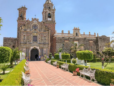
The Zocalo, or main plaza, in Cholula provides a focal point for the town; as well as being Cholula’s principal meeting place, it’s also host to a number of restaurants, cafes, and small stores situated behind the arches of the Municipal Palace facing the main plaza.
Churches near the Center
According to legend, Hernan Cortes ordered one church to be built in Cholula for every day of the year; in actual fact the city is host to about 40, a considerable number in relation to the size of the town’s population. The Ex Convento de San Gabriel, along the east side of the main Plaza, is a major landmark inside a walled garden hosting three churches: Capilla de Tercera Orden, Capilla Real and Templo de San Gabriel.
Church Bells Concert
One of Cholula’s most famous (well attended) events is the annual concert of church bells held in November each year (exact dates vary). The city lights are all turned off, and townspeople carry candles to the center of town to gather in communion and enjoy the music of the bells.
Cholula Archaeology Park
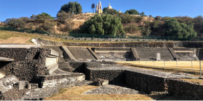
Cholula’s ‘claim to fame’ on the world archaeology map, is that its archaeology park, known simply as “Zona Arqueologica de Cholula” is host to the world’s largest pyramid—by volume. The Piramide Tepanapa, or ‘Great Pyramid of Cholula’, is the widest pyramid ever built. In its hey-day it measured 1,476 feet across and 213 feet high; thus by volume it is larger than Ceops in Egypt. The Spanish built a church on top the pyramid, the Santuario de Nuestra Señora de los Remedios; it’s unclear whether the Spaniards were aware at the time that a pyramid existed underneath the grassy mound.
Entrance to the park begins with a walk through a 1,200 foot length of tunnel through the Great Pyramid. Some areas of the Great Pyramid have been excavated and a small proportion of the extensive tunnels which burrow through the pyramid structure are open to visitors; they are best experienced as part of a guided tour. Archaeologists dug around five miles of tunnels to explore the structure which is made up up several pyramids built on top of one another, although most of the tunnels are not open to the public.
The ancient city’s main Plaza, Patio de los Altares, may also be seen on the south side of the archaeology park. The small museum, across the way from the entrance, was opened in 1971 and shows an excellent cut-out model of the pyramid and a reconstruction of the ancient site as well as artifacts recovered from the excavations at the archaeology site.
A walk up to the church, at the top of the pyramid, rewards you with neoclassic architecture and good views of the city, the Valley of Puebla, and of the volcanoes — although you’ll need to attend the area in the morning for the best views of the volcanic mountains.
https://www.visitmexico.com/en/puebla/atlixco/cerro-de-san-miguel-san-miguels-peak
Museums in Cholula
Franciscan Library
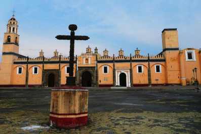
This building, situated in the grounds of the Ex Convento de San Gabriel, has been beautifully restored and stocks some 24,000 tomes of public works dating back to the 16th and 17th centuries. The works principally cover the topics of religion, theology, philosophy and fine art; they are published predominantly in Latin and old Spanish.
Museo del Caballero Aguila
For something different and unique, visit this museum which features a walking tour of the history of Cholula, said to the be longest continually occupied residence in North America, from pre-Hispanic times to the present-day.
Casa de la Cultura
Cholula’s Cultural Center features temporary exhibits and workshops covering a range of cultural themes including art, music, theater, paintings, etc.
https://www.mexperience.com/travel/colonial/cholula
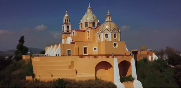
CHOLULA vs ATLIXCO, PUEBLA. Which is the BEST PUEBLO MAGICO?
https://youtu.be/swi2l2xhEoM
6. History
Pre-Hispanic period
The name of Cholula comes from the Nahuatl word (Nahuatl languages: Cholōllān). Its etymology has been explained either as "where water falls," or "place of those who fled" or a combination of the two. "Place of those who fled" is a reference to a myth that describes the arrival of Toltec refugees to this area because of the fall of Tula in 1000 CE. One Mexica myth states that the people of Cholula, called Chololtecs, were descended from one of the seven Aztec tribes that migrated to central Mexico from their mythical homeland Aztlan.
Settlement of Cholula began between 500 and 200 BCE (middle Pre Classic period), with two small villages established near water sources in what is now the eastern side of the city. They were two of a number of agricultural villages with ceremonial centers in the area, with evidence of emerging social stratification. Its earliest settlers were probably speakers of Oto-Manguean languages, linguist Terrence Kaufman has proposed that they were speakers of the Chorotega language of the Mangue branch of the Oto-mangue family. The various small rivers and streams allowed for irrigated agriculture and at one time, several converged into a shallow lake, which may have been used for chinampas. At the end of the Pre-classic, many other settlements in the area were abandoned but Cholula grew, possibly with migration from these other settlements. This made Cholula the dominant political force in the region. This was also the time when work on the Great Pyramid began, along with another monument called the Red Building. Cholula continued to grow during the Classic period (200 - 800 CE) to an extension of over 2 square kilometers (0.77 sq mi) and a population of between 20,000 and 25,000. It also remained dominant over the Puebla-Tlaxcala region, with more monumental construction, including the addition of two stages to the Great Pyramid.
During this time period, there is also evidence of influence from the larger Teotihuacan in the Valley of Mexico. However, the exact nature of the relationship between the two cities is not entirely known. One stage of the Great Pyramid is done in talud-board architecture, similar to that of Teotihuacan, but the next stage uses a different style, with stairs leading to the top on all four sides. The stage after this one, built during the decline of Teotihuacan, again returns to talud-board. Pottery styles between the two cities are similar, especially in the early Classic period, but living spaces and some religious iconography was different. When Teotihuacan declined, Cholula also suffered a significant population decline. At this time, the area took part in the Epi-classic central Mexican culture, and the iconography changes to show Gulf coast influence. Religious focus was kept on the Great Pyramid, but added its own layers to the work.
In the 12th century, Nahua peoples migrated to the Valley of Puebla after the fall of Tula. Eventually, this group was able to displace the Oto-mangue speakers as the ruling class, pushing them to the area south of the Great Pyramid. Kaufman has proposed that the displacement of Mangue speakers to southern Mesoamerica happened at this point. However, the remaining in this area retained a certain amount of political autonomy, which would create division in the city that remains to this day. The new lords, calling themselves the Chololtecs, shifted religious focus away from the Great Pyramid and to a new temple constructed to Quetzalcoatl. As part of this shift, some of the final construction phases of the Pyramid were destroyed. However, the Chololtecs would face continued hostilities from the previous inhabitants who dominated settlements around the city.
In the Post-classic period, Cholula (900–1521) grew to its largest size and returned to its status as a regionally dominant city. The city's location was strategic, on the trade routes between the Valley of Mexico, the Valley of Oaxaca and the Gulf of Mexico, making it a major mercantile center. A variant of an artistic style and iconography, especially in pottery, spread from Cholula to Culhuacán in and other areas in the Valley of Mexico, then to other areas in Mesoamerica. This cultural trait is called Mixteca-Puebla and it was spread by the vast trading networks that existed in Mesoamerica at that time. The split between the ethnic divisions of the city would eventually coalesce into three areas by the late pre-Hispanic period, which are now known by the names of San Pedro Cholula, San Andrés Cholula and San Isabel Cholula. Only the first two are considered part of the city today.
Colonial period
By the time the Spanish arrived, Cholula was a major religious and mercantile center, with the Quetzalcoatl Temple one of the most important pilgrimage sites in the central Mexican highlands. Hernán Cortés estimated that the city had 430 temples and about 20,000 homes in the center of the city with another 20,000 on the periphery. Cortés was attracted to the pastureland of the valley area, but while there was a great deal of irrigated farms, the city had a population of about 100,000 and overpopulation meant that many poor people often lacked food.
Cortés had arrived to Cholula after the Spanish victory of the Tlaxcalans, and he was supposed to meet Moctezuma II here. Since Cholula was allied with the Aztecs, the Spanish and their new Tlaxcalan allies were suspicious of this arrangement. There are two accounts of what happened next. Spanish accounts tell of Cortés being warned through La Malinche of a plot to attack the Spanish. Cortés called the leaders of the city to the central square of the city where the Spanish were with their weapons. On signal, the Spanish charged and killed as many as six thousand Chololtecs. However, the Aztec record states that the Spanish attack was unprovoked and there was no plot against them. The event is called the Cholula Massacre, and it resulted in many deaths and destruction of much of the city.
However, unlike many other pre-Hispanic cities, which were abandoned or destroyed before or immediately after the Conquest, Cholula has remained to this day. Nearby in the same valley the Spanish built the city of Puebla, which grew to prominence rapidly. Between this and an epidemic, which claimed much of its indigenous population, Cholula never recovered its former importance. The area was first divided into encomiendas, such as that of Andrés de Tapia who held the San Andrés portion. In 1531, the entire city became a "corregimiento" or area under direct control of the Spanish Crown.
Cholula was given the status of a city in 1535, and granted a coat of arms in 1540 by Charles V. Over the colonial period, forty seven churches were constructed in the city. However, the division of the city along ethnic lines, would impact itself again. In 1714, the San Andrés sector of the city, where most of the indigenous people lived, petitioned to be separated from the San Pedro sector to become an "Indian republic," and it was granted. This gave this part of the city limited autonomy.
Independence to the present
San Pedro and San Andrés were formed into two municipalities in the 1860s under the 1861 Puebla Constitution. The city that spans the two political entities was named the Cholula de Rivadavia District in 1895 by the state in honor of Bernardino Rivadavia.
7. Other Information: the neighborhoods and their religious festivals
Barrios and cargas
The city of Cholula is made up of two municipalities: San Pedro Cholula and San Andrés Cholula. The more important social division is a system of neighborhoods or barrios. San Pedro consists of eight neighborhoods: are San Miguel Tianguisnahuac, Jesús Tlatempa, Santiago Mixquitla, San Matias Cocoyotla, San Juan Calvario Texpolco, San Cristóbal Tepontla, Santa María Xixitla, La Magdalena Coapa, San Pedro Mexicaltzingo and San Pablo Tecama. San Andrés consists of ten: San Miguel Xochimehuacan, Santiago Xicotenco, San Pedro Colomoxco, Santa María Coaco, La Santísima, San Juan Aquiahuac, San Andresito and Santo Niño. In the pre-Hispanic period, the city was a mixture of ethnicities. What unified them was a common religious belief. After the Conquest, the Spanish reorganized the prehispanic neighborhoods or capullis around various patron saints. These neighborhoods remain to this day, whose names refer to their patron saint affixed before the original pre-Hispanic name. The neighborhoods closest to the center are urbanized, with those on the edges of the city maintaining more of their rural character, with economies based on agriculture and brick making.
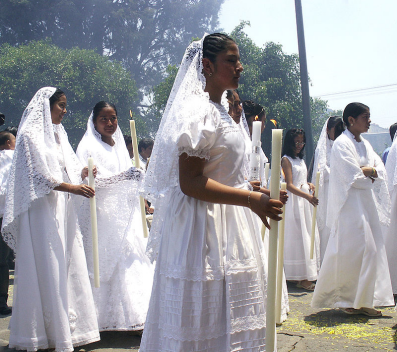
Despite five centuries of change and growth since the Conquest, modem Cholultecans maintain many traditional practices, which exist within a vital fabric of local religious and cultural life. These traditional practices very likely have pre Hispanic roots, including a ten-year cycle, called the "circular" of rotating citywide religious duties among the various neighborhoods. They continue today.
There are religious festivals of one kind or another almost all year round somewhere in the Cholula area. Social life within and among the various neighborhoods is organized around these religious events, as well as traditions involving communal labor and commercial patterns. People and entire neighborhood rotate certain religious and ceremonial duties, which are called cargas. Many revolve around neighborhood and other local patron saints. These festivals require much work, money and organization. For example, during major festivals, the church of San Andres is richly decorated in flowers, and there are sand paintings called carpets on the ground in Biblical designs. During the week-long feast of Saint Andrew, there is also folk ballet, musical performances and firework shows at night. The most important festival in any of the neighborhood is that of the patron saint. The night before the church is decorated with lamps and then fireworks are set off to announce the event. The next day, Las Mañanitas is sung to the image, there are a number of Masses and it is possible to receive a "visit" by the image of another saint from another neighborhood. During one of the Masses, the carga is transferred to a new mayordomo or person in charge, which is usually attended by mayordomos from other neighborhoods. After this mass, food is offered to all in attendance.
Cargas generally last for one year and start small, such as being in charge of cleaning the neighborhood church, collecting alms and acting as a go-between for the priest and parishioners. However, most involve the sponsorship of the many religious festivals that take place in the city. This system is one of the more complex of its type in the world. Receiving a carga gives the person, called a mayordomo, prestige from the community since he is considered to be working for the common good. Mayordomos can be men, women and even children. The most prestigious carga is to be the mayordomo of the neighborhood's patron saint. This mayordomo receives a certain amount of authority and even a silver scepter along with physical possession of the image. The wives of these mayordomos, carry silver baskets. Even more prestigious than this is to be a mayordomo of a citywide festival which is organized among the neighborhoods. These include the festival of the Virgin of the Remedies, the Fiesta del Pueblo, and events related to Holy Week.
8.Contact Information: San Andrés and San Pedro

City Mayor: María Fabiola Karina Pérez Popoca
Contact number: +52 (222) 403 7000
Govt. Office Address: Calle 16 de Septiembre 102, Centro San Andrés Cholula, 72810 San Andrés Cholula, Pue.
FB: https://www.facebook.com/KariPerezPopoca
Twitter: https://twitter.com/KariPerezPopoca
Website: https://sach.gob.mx
