Culiacán, Sinaloa 作者: 来源: 发布时间:2021-11-10
1.Population and Area
Pop: 785,800 (urban area)
Area: 65 km2 (city)
Elev: 71 masl
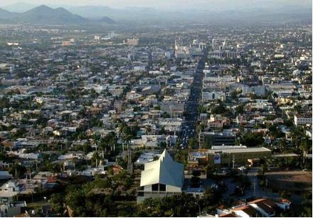
Culiacán location in Mexico within the state of Sinaloa
https://goo.gl/maps/d1mhh41p5Kj3tb8CA
2. Natural geography
Nature and weather
Terrain and hydrography
The terrain of the municipality is well defined by a mountainous part and the coastal plain; the physiographic region of the highlands is a relatively large portion that is part of the Pacific slope of the Sierra Madre Occidental, which has heights of 300 to 2,100 meters above sea level. The municipality of Culiacán is crossed by four hydrological currents: the Humaya, Tamazula, Culiacán and San Lorenzo rivers; Humaya has its origin in the State of Durango, entering Sinaloa through the municipality of Badiraguato; its waters are controlled by the dam Licenciado Adolfo López Mateos. The Tamazula River rises in the Sierra Madre Occidental near the Topia Valley; its current is controlled by the Sanalona dam; the Humaya and Tamazula rivers unite in front of the city of Culiacán to form the Culiacán River, which finally empties into the Gulf of California; the San Lorenzo river is born in the Sierra Madre Occidental within the State of Durango, enters Sinaloa through the municipality of Cosalá and empties into the Gulf of California.
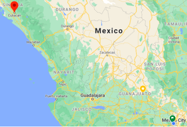
Flora anda Fauna
The main vegetation cover is the thorn forest, but mangroves, tropical deciduous forest, tropical sub-deciduous forest, Quercus forest and Quercus forest with Pinus are also found, although on a smaller scale. The main objective of this work was to develop a catalog and database of the flora of the municipality where information on the altitudinal distribution of the flora, the floristic structure of the types of vegetation, growth habit and endemic species could be obtained. In the preliminary inventory of the flora, based on 8,300 collections, the richness of vascular plants can be estimated in about 1,380 species
The fauna are: rabbit, raccoon, duck, pichihuila, pigeon, quail, swallow, turtle, lizard, crocodile, iguana, snake, white-tailed deer, wild boar, puma, scorpion and alligator.
https://www.gbif.org/dataset/1a523735-7023-4457-8075-55ed885a5163
https://www.ecured.cu/Culiac%C3%A1n_(M%C3%A9xico)
Köppen Classification: Tropical Savanna Climate
Tropical savanna climates have monthly mean temperature above 18°C (64°F) in every month of the year and typically a pronounced dry season, with the driest month having precipitation less than 60mm (2.36 in) of precipitation. In essence, a tropical savanna climate tends to either see less rainfall than a tropical monsoon climate or have more pronounced dry seasons than a tropical monsoon climate. Tropical savanna climates are most commonly found in Africa, Asia and South America. The climate is also prevalent in sections of Central America, northern Australia and North America, specifically in sections of Mexico and the state of Florida in the United States.
The Köppen Climate Classification subtype for this climate is "As". (Tropical Savanna Climate).
The average temperature for the year in Culiacan is 76.0°F (24.4°C). The warmest month, on average, is June with an average temperature of 85.0°F (29.4°C). The coolest month on average is January, with an average temperature of 67.0°F (19.4°C).
The highest recorded temperature in Culiacan is 106.0°F (41.1°C), which was recorded in May. The lowest recorded temperature in Culiacan is 38.0°F (3.3°C), which was recorded in January.
The average amount of precipitation for the year in Culiacan is 21.3" (541 mm). The month with the most precipitation on average is August with 6.5" (165.1 mm) of precipitation. The month with the least precipitation on average is April with an average of 0.0" (0 mm). In terms of liquid precipitation, there are an average of 43.9 days of rain, with the most rain occurring in August with 12.8 days of rain, and the least rain occurring in April with 0.2 days of rain.
https://www.weatherbase.com/weather/weather-summary.php3?s=21467&cityname=Culiacan%2C+Sinaloa%2C+Mexico&units=
Getting there and around
Get there
By plane
Federal de Bachigualato International Airport (CUL IATA). Volaris offers three daily flights from Tijuana. A one-way ticket costs about $100 USD. There are also Volaris flights to Culiacán from Guadalajara and Mexico City.
By car
Mexican Federal Highway 15 (Carretera Federal 15) connects Culiacán to cities in Sonora state such as Nogales, Hermosillo, Guaymas, Ciudad Obregón, and Navojoa (from north to south), as well as Los Mochis, Guasave, Guamúchil, Mazatlán, Tepic, and Guadalajara. Toll booths and checkpoints are stationed throughout the highway.
By bus – The 2 'Millennium' International Buses Station is a major hub offering connections to various small towns around the state of Sinaloa. There are regular buses to Culiacán from Los Mochis, Mazatlán, Hermosillo, and Guadalajara.
https://en.wikivoyage.org/wiki/Culiac%C3%A1n
Car Rental – To explore Mexico’s provincial towns and cities—including its beach locations and the scenery and attractions near them— consider renting a car for your visit. Having your own car will give you more flexibility than using public transport options and, in some cases, offer you access to places which are otherwise difficult to visit without the use of a car.
COVID19 - International entry into Mexico from United States
Allowed for: All visitors arriving by air. Mexico land borders are closed to non-essential travel
Restricted for: There are no current restrictions.
Get around
By car
AGA Rent-A-Car has been renting vehicles to travelers and local renters since 1989. Its first location opened in Mazatlan, Sinaloa, and it has since expanded to serve Los Mochis and Culiacán, with locations both at the airport and in town.
Local Buses – Local buses and mini-buses (combis or micros) are available locally for a fraction of the cost of a taxi around town. You need to speak Spanish to be able to ask for directions or ask the driver to tell you where to get off.
Taxis – Taxis in most of Mexico’s towns and cities are not metered, so agree your price before you get in. Taxi travel is very affordable in Mexico, in comparison to the USA, Canada and Europe, and so provides a viable means of public transportation in Mexico. Your hotel can arrange taxis for you; some post their rates on a board in the lobby; taxi hotel rates are usually higher than cabs you hail off the street. If you speak Spanish, you will have a distinct advantage and be able to negotiate a price with the driver.
Uber is expanding rapidly across Mexico and now offers services in cities across the country, including: Mexico City, Toluca, Cuernavaca, Puebla, Querétaro, León, Aguascalientes, San Luis Potosí, Guadalajara, Monterrey, Hermosillo, Tijuana, Mexicali, and Mérida. Uber has been adding Mexican cities to its network every year, check for availability when you arrive at your destination in Mexico.
Cabify and Didi are also developing and currently operate in cities including Mexico City, Toluca, Monterrey, Puebla, Querétaro and Tijuana. Check for availability in the city you are visiting.
These services offer people with smartphones a way to book a cab through a mobile app for a pre-agreed price. Fares are comparable with Sitio type cabs, and sometimes trade at a premium to this when local demand increases.
https://www.mexperience.com/transport/taxi-travel-in-mexico/#51
3. ECONOMY
GDP: 60510.2 M MXN (2010)
https://dialnet.unirioja.es/descarga/articulo/4954700.pdf
4. Industry characteristics
Culiacán's economy is mainly agricultural and commerce, being a trade center for produce, meat, and fish. Among other industries, Culiacán represents 32 percent of the state economy.
Sinaloa is the national leader of the food industry, and Culiacán is the leader in the state with a production of around five million tons of corn (2007). It also leads the production of vegetables (tomato, cucumber, chili, eggplant and pumpkin), fruits (mango, melon and watermelon) and grains (beans, soybeans, safflower, rice, wheat and sorghum).
Livestock is also an important activity. The rearing and fattening of cattle, goats, sheep and pigs and the production of meat and milk - derived from these species - place the city in the national leadership of this industry.
The poultry industry also has an important development, raising and fattening hundreds of thousands of chickens a year, an industry that also makes an important contribution to the municipal GDP.
Coppel, Casa Ley, Homex and other companies of national importance are headquartered in Culiacan.
https://www.gob.mx/promexico/acciones-y-programas/culiacan
5. Attractions
Culiacán Botanic Garden
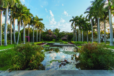
The Culiacán Botanical Garden is a 10 hectare public space whose main functions are the conservation of botanical species, scientific research, environmental education and cultural promotion.
This international botanical sampler has more than 1,000 different plant specimens, of more than 400 genera and of around 100 families, grouped in 19 collections. In turn, these botanical species coexist with pieces of contemporary art and first-rate architectural spaces, introduced to the garden in order to enrich the visitor's experience during their tour of the place.
It’s fantastic to hear the chirping of birds that nest in the crowns of tall trees up to 50 m high and to contemplate the flapping of a friendly hummingbird or a beautiful butterfly. The gigantic Talipot palms from Ceylon are a great attraction in the garden as well as the great diversity of palm trees in our country, here you will know the properties and characteristics of each plant since the common names, scientific and characteristics are described in small signs placed at the foot of each species. There is a very wide collection of bamboos, as well as cacti such as biznaga, nopal and the one known as cow's tongue. There are also aquatic ones such as water lilies in coexistence with frogs, turtles, snails and fish.
https://es.wikipedia.org/wiki/Jard%C3%ADn_bot%C3%A1nico_Culiac%C3%A1n
Culiacán Zoo
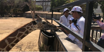
The Culiacán Zoo has a wide collection of fauna such as felines, primates, birds, herbivores and reptiles, among which are very interesting animals such as the cheetah, king vulture, giraffe, chimpanzee, white lion, Madagascar lemur, tree boas and Gila monsters.
Start your tour in the aviary amidst birds in flight. Delve into the fascinating world of reptiles in our herpetarium, where you can observe exotic species in a completely safe environment.
In the feline corridor you will find surprising African species and from other parts of the world such as: white lions, tigers, etc.
You can also visit the savannah at the zoo where you can feed the giraffe and meet dromedaries, antelopes, ostriches and other animals.
Do not forget that throughout the day there are educational presentations at the Meeting Point for you to learn and have fun.
Take a fun ride on the little train or enjoy a refreshing afternoon on the Zambezi.
https://zooculiacan.com
Sinaloa Science Center
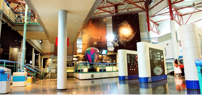
Within this center you can carry out multiple activities that will be fun for all ages, from visiting the different rooms of its Interactive Museum, to enjoying a projection in its planetarium, even participating in some of the multiple workshops and visits to laboratories. The place will not only be entertaining for children, youth and adults, you will also leave with a lot of knowledge and a new worldview. Currently the museum was renovated and opened the Materia Museum, which has a black cube, where you can experience for the first time in all of Mexico, the virtual reality projected in 8k format, technology that only existed in Australia.
https://www.zonaturistica.com/en/things-to-do/sinaloa/culiacan/sinaloa-science-center
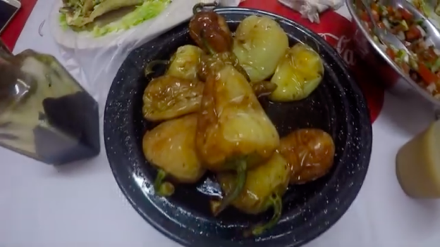
Visiting Culiacan Sinaloa - One of Mexico's Most "Dangerous" Cities
https://youtu.be/FArtdIkN_J4
6. History
Prehispanic era
In ancient times, there was an indigenous population called Huey Colhuacan that dates back to Tecpatl, which corresponds to the year 628 of our era; the Aztecs built it during their pilgrimage. Its exact location is unknown, but it is assumed that it was close to the current town of Culiacancito. Here he was born in 1065 A.D. the cult of Huitzilopochtli, the warrior god of Aztec mythology.[3] The ancient settlers were called Culichis.
Virreinal time
The city that we know today as Culiacán was co-founded in 1531 by Lázaro de Cebreros and Nuño Beltrán de Guzmán under the name of Villa de San Miguel. Upon their arrival in the 16th century, the Spanish found the existence of farmhouses organized in indigenous nations by the tribe of the Tahues, which brought together a group of people of the same origin and language who had a common tradition, their limits were the elements natural, like rivers, mountains, among others.
Other indigenous peoples that inhabited the original territory of Culiacán were the Tebacas, Pacaxes, Sabaibo and Achires.
After their war of conquest, Lázaro de Cebreros and Nuño Beltrán de Guzmán (1531), organized the territories acquired in three provinces, one of them was Culiacán which was delimited, to the south, by the Elota river and in the north by the Mocorito River, depending on the Kingdom of Nueva Galicia. Organized in this way, it lasted until 1786, the year in which the administration system was implemented, with Sonora and Sinaloa forming the administration of Arizpe and the ancient province of Culiacán gave life to the party of the same name with equal jurisdiction.
Independent Mexico
On October 6, 1821, Independence was sworn in Culiacán. Culiacán is granted the category of city, on July 21, 1823, when the provinces of Sonora and Sinaloa separated by decree from Congress. In 1824, by Constitutive Act of the Mexican Federation, Sinaloa and Sonora meet again, forming the state of the West. In 1830, the provinces of Sonora and Sinaloa were definitively separated, by decree of October 13, 1830, the city of Culiacán being designated capital of the state of Sinaloa. Later, during the conservative government related to the French Intervention in 1861, prefectures were installed and the Municipalities Law was decreed that divided the Districts into City Councils. The Badiraguato District was suppressed and became part of the Culiacán District as a Municipality.
From 1859 to 1873 it ceased to be the capital of Sinaloa, which moved to Mazatlán. Already in the Restored Republic, Governor Eustaquio Buelna confronted the merchants of the port. He returned to Culiacán and the Local Congress gave him the status of capital of the state.
Porfirian and revolutionary times
For 1878, Culiacán had three City Halls, whose headwaters were Culiacán, Quilá and Badiraguato, it remained that way until in 1880 Badiraguato returned to being a district with the limits that previously corresponded to it.
1912 was the year in which the Municipalities were established by law as a new form of internal government, but it was until 1915 that the Political Directories were suppressed, this law coming into force, causing the Districts to become free municipalities.
Culiacán was established as a Municipality by decree published on April 8, 1915, comprising within its limits the current Municipality of Navolato that was segregated in 1982, according to a decree of August 27 of that year, thus losing 2,285 km² of the valley agricultural.
Some time later, the State Congress approved the extension of the name of the capital city, giving it its current official name, Culiacán de Rosales, in honor of the great Mexican military man, Antonio Rosales.
After World War II
Beginning in the late 1950s, Culiacán became the birthplace of an incipient underground economy based on illicit drugs exported to the United States. The completion of the Pan-American Highway and the regional airport in the 1960s accelerated the expansion of a workable distribution infrastructure for the enterprising few families that would later come to dominate the international drug cartels along Mexico's Pacific Northwest.
7. Other Information
Drug Violence in Mexico
Drug-related violence in Mexico has been making news headlines again this month. The wanton slaying of US consulate staff in Ciudad Juarez, which followed hot on the heels of the murder there of sixteen teenagers in late January has further blighted a city considered hopelessly mired by the influence of drug cartels who control the area by ruthless means; a part-and-parcel characteristic of their multi-billion dollar annual business.
The drug trade is a business: illicit, immoral, destructive—but a business, nonetheless. If the demands for addictive chemicals were not so acute in relatively affluent nations including the United States and Western Europe, these cartels would dissolve into the very darkness they ply; alas, affluence brings with it a myriad of challenges, one of which appears to be an unfathomable and insatiable thirst for drugs and narcotics.
While we can all count upon the mainstream media to report the blood and bullets ad nauseam, it’s wise to maintain composure of mind in relation to the bigger picture in Mexico—the most remarkable fact is that the overwhelming majority of cities and towns across the length and breadth of Mexico are peaceful, tranquil and non-violent.
The media’s omission of this important wider aspect presents an opportunity for observers who are willing to probe behind the headlines. Tourists’ and visitors’ risks of being touched by drug violence have been, and remain, minuscule. Expats who have lived in Mexico for some while now and consider the country their home, full or part-time, know that while there are risks in Mexico, they are no higher and perhaps even considerably lower than the risks they are presented with in their home countries.
When you take the time to delve into the reams of statistics published on the subject, you’ll find that Mexico is considerably less risky to one’s health and well-being than many other places in the world. To really understand this, you need to visit Mexico in person—the cities and towns where tourists go and enjoy their vacations; and the increasing number of locations where expats move to and take quiet enjoyment of lives among the communities they have chosen to adopt here.
Ciudad Juarez, Culiacan, Tijuana are today not a true representation of Mexico. To say that all Mexico is like this would be to say that Forbes roll-call of ‘America’s most dangerous cities’ is a representation of the United States as a whole. Clearly, it is no such thing.
https://www.mexperience.com/drug-violence-is-back-in-the-news
8.Contact Information
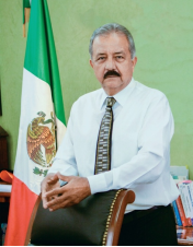
City Mayor: Jesús Estrada Ferreiro
Contact number: +52 (667) 758 0101
Govt. Office Address: Av. Alvaro Obregón y Mariano Escobedo C.P. 80000 Culiacán, Sinaloa., México
FB: https://www.facebook.com/estradaferreiro
Twitter: https://twitter.com/JesusEFerreiro (not updated recently)
Website: https://www.culiacan.gob.mx
