La Paz, Baja California Sur 作者: 来源: 发布时间:2021-11-10
1.Population and Area
Pop: 290,286 (metro)
Area: 20.275 km2 (munip.)
Elev: 27 masl
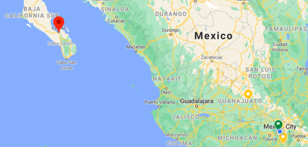
La Paz location in Mexico within the state of Baja California Sur
https://goo.gl/maps/aoT9M1twooN1N1Vw5
2. Natural geography
Nature and weather
The natural environment of La Paz shares characteristics with the rest of the coastal environment of the state of Baja California Sur.
Characteristics and land use
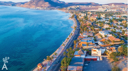
It is characterized by the mountains and the coastal plain. The mountain range parallel to the coast, with gentle slopes to the west and steep towards the Gulf of California, extends to the sea and has an average altitude of 600 m. It is formed by rocks of volcanic origin and receives the local name of Sierra de la Giganta. A wide coastal plain to the west, with an average width of 40 km, allows the formation of extensive plains and of marine sedimentary rocks, especially limestone. To the east there are narrow beaches.
Flora
The existing vegetation, typical of arid zones, is made up of organisms that have adapted to their environment, which can withstand high temperatures and very long periods without receiving any precipitation; Thus, there are the following types of vegetation: Crasicaule scrub, which are the cardones. nopaleras, viznagas, choyas, palo adán, pitahaya, governor and garambullo. Another species is the Deciduous Low Forest formed by lomboy, torote, palo blanco, etc. This type of vegetation is determined by trees no more than 15 meters high. In the plains and deserts there is the cardón, mesquite, chirinola, lechuguilla, governor; And in the mountains: pine and oak forests.
Fauna
Regarding the fauna, we can point out that its distribution is due to the existing vegetation by zones, such as: in the most desert plains where there is little vegetation, we find the chacuaca or quail, rabbit, hare and coyote, among others. In the regions with more vegetation, animals are generally found, such as raccoons, deer, foxes and wild cats. As for the marine fauna, we can find the seal, the dolphin and the gray whale, the latter being the most visited by tourists.
http://www.inafed.gob.mx/work/enciclopedia/EMM03bajacaliforniasur/mediofisico.html
Köppen Classification: Tropical and Subtropical Desert Climate
This climate is dominated in all months by the subtropical anticyclon, or subtropical high, with its descending air, elevated inversions, and clear skies. Such an atmospheric environment inhibits precipitation. Most of Earth's tropical, true desert climates occur between 15° and 30° latitude. The most extreme arid areas also are far removed from sources of moisture-bearing winds in the interiors of continents and are best developed on the western sides of continents, where the subtropical anticyclone shows its most intense development. An exception to the general tendency for aridity to be associated with subsidence is in the Horn of Africa region, where the dryness of Somalia is caused more by the orientation of the landmass in relation to the atmospheric circulation. Both the high- and low-sun monsoonal winds blow parallel to the coast, so that moisture-laden maritime air can penetrate over land only infrequently.
The Köppen Climate Classification subtype for this climate is "Bwh". (Tropical and Subtropical Desert Climate).
The average temperature for the year in La Paz is 74.7°F (23.7°C). The warmest month, on average, is August with an average temperature of 86.2°F (30.1°C). The coolest month on average is January, with an average temperature of 63.1°F (17.3°C).
The highest recorded temperature in La Paz is 108.0°F (42.2°C), which was recorded in September. The lowest recorded temperature in La Paz is 35.6°F (2°C), which was recorded in January.
The average amount of precipitation for the year in La Paz is 6.7" (170.2 mm). The month with the most precipitation on average is September with 2.3" (58.4 mm) of precipitation. The month with the least precipitation on average is April with an average of 0.0" (0 mm). In terms of liquid precipitation, there are an average of 18.4 days of rain, with the most rain occurring in August with 4.2 days of rain, and the least rain occurring in May with 0.1 days of rain.
https://www.weatherbase.com/weather/weather-summary.php3?s=50467&cityname=La+Paz%2C+Baja+California+Sur%2C+Mexico&units=
Getting there and around
Get there
By plane – You can get to La Paz by air from Mexico City, Guadalajara, Tijuana and Los Angeles (USA). The airport is about 10 miles (16 km) southeast of La Paz. Land transport is available from the airport into town.
By car – Driving to La Paz from the southern border of the United States will take you about 20-24 hours on Highway 1. There is a car ferry that makes a crossing from La Paz to Topolobambo (near Los Mochis) and Mazatlan.
By bus – To get to Baja California Sur from the United States, your best bet is to fly there; the bus journey from Tijuana to La Paz is about 27 hours; then a further 2 hours from there to Los Cabos.
By ferry – If you are on Mexico’s mainland, or want to get to it, there is a ferry that crosses the Sea of Cortes (also known as the Gulf of California) to and from La Paz to the port cities of Mazatlan and Los Mochis (Topolobambo). The ferry trip to/from Mazatlan takes 18 hours and does not run daily; sleeping cabins are available with advance bookings. The ferry to/from Los Mochis (Topolobambo) takes around 8 hours and does not sail daily either. A catamaran ferry service between Topolobambo and La Paz has been introduced which cuts the journey time in half based on the previous ferry services.
https://www.mexperience.com/travel/beaches/la-paz
Car Rental – To explore Mexico’s provincial towns and cities—including its beach locations and the scenery and attractions near them— consider renting a car for your visit. Having your own car will give you more flexibility than using public transport options and, in some cases, offer you access to places which are otherwise difficult to visit without the use of a car.
There are several car rental agencies. Rent something modest and unassuming.
COVID19 - International entry into Mexico from United States
Allowed for: All visitors arriving by air. Mexico land borders are closed to non-essential travel
Restricted for: There are no current restrictions.
Get around
Local Buses – Local buses and mini-buses (combis or micros) are available locally for a fraction of the cost of a taxi around town. You need to speak Spanish to be able to ask for directions or ask the driver to tell you where to get off.
Taxis – Taxis in most of Mexico’s towns and cities are not metered, so agree your price before you get in. Taxi travel is very affordable in Mexico, in comparison to the USA, Canada and Europe, and so provides a viable means of public transportation in Mexico. Your hotel can arrange taxis for you; some post their rates on a board in the lobby; taxi hotel rates are usually higher than cabs you hail off the street. If you speak Spanish, you will have a distinct advantage and be able to negotiate a price with the driver.
Uber is expanding rapidly across Mexico and now offers services in cities across the country, including: Mexico City, Toluca, Cuernavaca, Puebla, Querétaro, León, Aguascalientes, San Luis Potosí, Guadalajara, Monterrey, Hermosillo, Tijuana, Mexicali, and Mérida. Uber has been adding Mexican cities to its network every year, check for availability when you arrive at your destination in Mexico.
Cabify and Didi are also developing and currently operate in cities including Mexico City, Toluca, Monterrey, Puebla, Querétaro and Tijuana. Check for availability in the city you are visiting.
These services offer people with smartphones a way to book a cab through a mobile app for a pre-agreed price. Fares are comparable with Sitio type cabs, and sometimes trade at a premium to this when local demand increases.
https://www.mexperience.com/transport/taxi-travel-in-mexico/#51
3. ECONOMY
GDP: 24787.9 M MXN
https://dialnet.unirioja.es/descarga/articulo/4954695.pdf
4. Industry characteristics
Eco-tourism is by far the most important source of tourism income in La Paz. Tourists also visit the city's balnearios. There are some 900 islands and inlets in the Gulf of California with 244 now under UNESCO protection as World Heritage Bio-Reserves and the Isla Espíritu Santo group, which borders the northeast portion of the Bay of La Paz, the primary tourist destination of the area.
Industries include silver mining, agriculture, fishing and pearls. Tourism is also an important source of employment for this coastal community.
Along with the area's marinas, new developments are emerging because of the proximity to the United States.
Key project: desalination plant in La Paz, Baja California Sur
The project consists of the design, construction, equipment, operation, maintenance and exploitation of the desalination plant in La Paz, in Baja California Sur, with a capacity of 200 l / s.
The project involves access and operation roads, direct marine catchment work, conduction work to the plant, membranes, pumping plants, connections, delivery points, lines, storage and regulation tanks, power lines, implementation of attention systems for contingencies, quality assurance, industrial safety and environmental protection.
The project will be carried out through a Public Private Association in percentages of 55 and 45 percent, respectively, the company that operates it will receive a consideration with a fixed and a variable component. At the end of the established 20-year period, the company must cede the plant to the municipal government.
The joint investment amount is 1,000 million pesos.
https://www.proyectosmexico.gob.mx/proyecto_inversion/0893-planta-desalinizadora-en-la-paz-baja-california-sur
5. Attractions
La Paz beaches
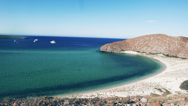
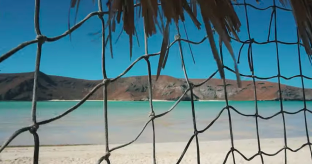
The beaches of Baja California will easily rival any you may have seen in the Caribbean or elsewhere no further than a few miles from La Paz. Soft sandy beaches and crystal clear waters are waiting here for you to experience and enjoy.
La Paz is a commercial port, so swimming in the waters nearby the city is not always ideal. The most popular beach for swimming is La Concha, which is just north of town. Beach tours will take you out to the more remote beaches, away from the crowds and the ships.
Nature and adventure experiences
La Paz is a perfect base from which to enjoy Mexico’s great outdoors and take part in a variety of nature and adventure experiences in Mexico.
The local ecology, the landscape, the climate and the proximity to the sea make this region a natural paradise for those who love being in nature. What’s more, you can find experienced and well-equipped local adventure companies in La Paz who are ready to help you enjoy the best of what this region offers.
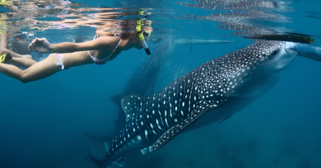
Fishing, kayaking, sailing, camping, surfing, horseback riding, nature walks, fabulous bird watching, cliff hikes, sunset cruises and watching the amazing (and harmless) whale sharks and sea lions are just some of the activities you can enjoy in the area.
https://www.mexperience.com/travel/beaches/la-paz
El Mogote dunes
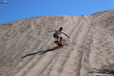
The steep hills of soft, fine sand at the neck of the peninsula create the perfect conditions for sandboarding. The top of the dunes overlooks endless stretches of cactus-covered landscape on one side and the deep blues of the Sea of Cortez on the other, so the views are just as epic as the adrenaline rush.
What to bring to sandboarding
Sandboarding is basically just snowboarding without all the cold weather gear and a much softer land pad if you do fall. Here is what you’ll want to bring when you go sandboarding in La Paz.
Shoes optional: the sand is really soft and it’s easy to strap in without shoes. If you go when the sand is hotter or feel more comfortable with shoes, then the option would be lightweight sneakers.
Light athletic clothing: It’s usually pretty warm and you will be getting sandy, so opt for clothing that will keep you cool and comfortable.
Sun protection: The sun is bright and hot out on the dunes, so bring sunglasses, a hat, and sunscreen.
https://nomanbefore.com/sandboarding-in-la-paz-mexico
La Paz, Mexico!
https://youtu.be/o5WUziQPYrE
6. History
First settlers
In a remote antiquity, estimated at fourteen thousand years, the first nomadic human groups with a subsistence economy arrived on the peninsula by way of the Pacific Ocean coast.
There were three perfectly defined tribal groups in pre-Hispanic times: the Pericúes, Guaycuras and Cochimíes. The Pericúes inhabited the southern part of the peninsula and extended northwards, from Cabo San Lucas to the middle part of the peninsula, the Guaycuras inhabited the middle part and the Cochimíes in the extreme north. In the vicinity of the current city of La Paz, signs of pre-Hispanic burials have been discovered, which shed light on the funeral customs of the Pericúes. In that sense, El Conchalito is a site of great archaeological importance.
Spanish discovery
The first European known to have landed in Baja California was Fortún Ximénez. In 1533, shortly after the conquest of Tenochtitlan, Hernán Cortés sent two ships, Concepción, under the command of captain and commander of the expedition, Diego de Becerra, and San Lázaro under Capt. Hernando de Grijalva, to explore the South Seas of the Pacific Ocean. The ships set out November 30, 1533, to travel north along the coast of New Spain from present-day Manzanillo, Colima, in search of two ships that had been lost without a trace on a similar voyage the previous year. By December 20 the ships had separated; San Lázaro, which had gone ahead, waited three days for Concepción and after no sighting of its companion vessel, Capt. Grijalva dedicated himself to exploring the region and discovered the Revillagigedo Islands. On board the Concepción, the navigator and second in command, Fortún Jiménez, led a mutiny in which Capt. Becerra was killed, then attacked the crewmen loyal to the murdered captain, abandoning the wounded on the coast of Michoacán along with the friars Franciscans who had accompanied him the expedition.
Jiménez sailed to the northwest following the coast and at some point turned west and reached a bay that is now the port of the city of La Paz. Jiménez thought that he had found an island, and never knew that it was a large peninsula. There he met natives who wore few clothes and spoke an unknown language; their culture was very different from that of the inhabitants of the Mexican highlands. The sexually deprived crews of his ships saw the scantily-clad women and took them by force. The Spaniards soon became aware of the large pearls that the natives extracted from the pearl oysters abounding in the bay, and proceeded to plunder the people and rape their women. Jiménez and his men did not name any of the places they found, it would be left to other explorers to name the places visited by Fortún Jiménez.
The abuse of the Indian women by the crew and their looting caused a violent confrontation with the natives that ended in the deaths of Fortún Jiménez and some of his companions; the survivors withdrew, and sailed erratically for several days until they reached the shores of the present-day Jalisco, where they encountered a subaltern of Nuño de Guzmán, who requisitioned the ship and took them prisoner.
Hernán Cortés arrives in California and founds the town of Santa Cruz
Having sponsored two exploratory voyages in the South Seas with no material results, Cortés decided to lead a third exploration himself. Annoyed that his enemy, Nuño de Guzmán, had requisitioned one of his ships during the first expedition, Cortés decided to confront Guzmán on his own ground and from there set up the third expedition; consequently he prepared a large force of infantry and cavalry to march on the province of New Galicia, of which Guzmán was governor.
The viceroy of New Spain, Antonio de Mendoza, warned Cortés on September 4, 1534, "not to confront he who had requisitioned his ships", a warning which Hernán Cortés ignored, claiming that he had been designated to conquer and discover new territories, and that he had spent more than 100 thousand gold ducats of his own fortune. The feared confrontation between the armies of Cortés and Nuño de Guzmán did not occur.
In Chametla, (Sinaloa), after crossing the present-day states of Jalisco and Nayarit, territory then known as part of New Galicia, Cortés and his entourage embarked the ships Santa Águeda and San Lázaro with 113 crewmen and 40 cavalrymen with their horses and gear, leaving 60 riders on land, as reported to the Real Audiencia and Governor Nuño de Guzmán. Cortés then sailed in a northwestly direction, and on May 3, 1535 arrived at the bay he named Bahia de la Santa Cruz (Bay of Santa Cruz), currently the port of La Paz, where he confirmed the death of his subordinate, Fortún Jiménez, at the hands of the natives. Once Cortés had taken possession of the bay, he decided to establish a colony and summoned the soldiers and arms he had left in Sinaloa. The transport ships were lost in a storm, however, and only one ship, carrying a load of fifty bushels of corn, returned. This was insufficient to feed the population, so Cortés left to personally secure food, but was unable to procure enough, so he decided to return to New Spain with the intention of supplying the new colony from there.
Francisco de Ulloa was in command of the town of La Paz, but complaints by relatives of those who had stayed on the peninsula caused the viceroy to order the population to abandon the colony and return to New Spain. Following this failure of Cortés' third expedition to establish a colony in the newly discovered lands that belonged to him by royal decree, an enemy of Cortés, whom a writer of the time cites as Alarcón, gave the name of the abandoned land in a mocking tone as California to insult him.
The Baja California peninsula, the Gulf of California (also known as the Sea of Cortez), and the states of California, Baja California and Baja California Sur, bear the name today.
From January 10, 1854, to May 8, 1854, La Paz served as the capital of William Walker's Republic of Sonora. The project collapsed due to lack of US support and pressure from the Mexican government to retake the region.
7.Contact Information
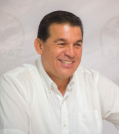
City Mayor: Rubén Gregorio Muñoz Álvarez
Contact number: +52 (612) 123 7900, ext. 1118
Govt. Office Address: Boulevard Luis Donaldo Colosio, entre Carabineros y Av. De los Deportistas, col. Donceles 28, CP 23080, La Paz, BCS.
FB: https://www.facebook.com/RubenMunozBCS
Twitter: https://twitter.com/rubengma
E-mail: presidente@lapaz.gob.mx
Website: https://lapaz.gob.mx
