Matamoros, Tamaulipas 作者: 来源: 发布时间:2021-07-23
1.Population and Area
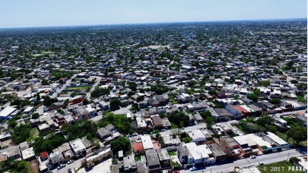
Pop: 520,367
Area: 4,046 km2 (city)
Elev: 9 masl
2. Natural geography
Nature and weather
Hydrography
The municipality belongs to the Rio Grande River basin, which through an irrigation system fertilizes the land and makes irrigated agriculture possible, the basis of the region's economy. The main sources of hydraulic supply are the Rio Grande and the Tigre stream, which has diversion dams, through channels and drains that bathe the region. It also has a series of fresh and salt water lagoons.
Orography and land classification
In general, its orography is flat, which allows irrigation systems.
The predominant soil unit is vertisols. They are deep soils with a layer of organic matter; due to their clayey nature, they tend to crack when they lack moisture. They are located in most of the Irrigation District 25 and have been exploited with modern mechanisms for more than 40 years.
In the western area of the municipal seat, the type of soil solonchak gléyco is identified, which has a high content of salts, hence the attack of nitrate on the buildings in the area is also common. In some portions located to the south and southeast of said headwaters, a luvic xerosol-type soil is identified, characterized by a clear surface layer and poor in organic matter; with clay deposits or carbonate and gypsum crystals.
Flora and fauna
Almost everything has been dismantled to dedicate the land to agriculture and livestock.
Within the flora there is a small portion of grassland land and there are small shrubs such as farmers, huisache, mesquite, ebony, anacua and palo blanco.
The fauna is made up of infinity of bands of birds in which the quail and the white-winged dove predominate. Coyote and opossum, route of the Monarch butterfly.
https://www.tamaulipas.gob.mx/estado/municipios/matamoros
Köppen Classification: Tropical Savanna Climate
Tropical savanna climates have monthly mean temperature above 18°C (64°F) in every month of the year and typically a pronounced dry season, with the driest month having precipitation less than 60mm (2.36 in) of precipitation. In essence, a tropical savanna climate tends to either see less rainfall than a tropical monsoon climate or have more pronounced dry seasons than a tropical monsoon climate. Tropical savanna climates are most commonly found in Africa, Asia and South America. The climate is also prevalent in sections of Central America, northern Australia and North America, specifically in sections of Mexico and the state of Florida in the United States.
The Köppen Climate Classification subtype for this climate is "Aw". (Tropical Savanna Climate).
The average temperature for the year in Matamoros is 74.1°F (23.4°C). The warmest month, on average, is June with an average temperature of 81.9°F (27.7°C). The coolest month on average is January, with an average temperature of 63.3°F (17.4°C).
The highest recorded temperature in Francisco Castellanos is 118.4°F (48°C), which was recorded in April. The lowest recorded temperature in Matamoros is 21.2°F (-6°C), which was recorded in December.
The average amount of precipitation for the year in Matamoros is 28.0" (711.2 mm). The month with the most precipitation on average is September with 6.1" (154.9 mm) of precipitation. The month with the least precipitation on average is February with an average of 0.5" (12.7 mm). In terms of liquid precipitation, there are an average of 54.6 days of rain, with the most rain occurring in September with 9.1 days of rain, and the least rain occurring in March with 1.8 days of rain.
https://www.weatherbase.com/weather/weather-summary.php3?s=928033&cityname=Francisco+Castellanos%2C+Tamaulipas%2C+Mexico&units=
Getting there and around
Get there
By foot
If crossing from the U.S. by foot, all three bridges between Brownsville and Matamoros charge a US$1 toll (and a US$0.25 toll to return). The turnstile is on the right side of the vehicle lanes in either direction.
You must bring a passport if you plan to return to the U.S., though you can enter the border zone of Mexico without it and will almost certainly not be asked to present documents. Mexican customs or the military or both may ask to search your bags, if you are carrying something. Note that in Brownsville U.S. customs officials do sometimes stop pedestrians heading for the bridge crossing and question them.
The wait to enter Mexico is negligible, but if you are planning to walk back across the bridge to the U.S. you might want to time it so that you do not have to stand for 30 minutes in extreme heat and humidity.
The bridge furthest east, the Veterans International Bridge at the end of HWY 77 on the Texas side, is not recommended for pedestrian crossing; it was designed for long-haul trucks and is a much longer bridge (and thus longer walk) than the other two. The bridge at International Blvd. is the shortest walk and more accessible to downtown Matamoros upon crossing.
By plane
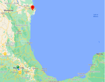
The quickest way to get from Mexico City to Matamoros is to fly which costs $2000 - $9000 and takes 3h 1m.
By car
The cheapest way to get from Houston to Matamoros is to drive which costs $700 - $1100 and takes 7h 16m.
The distance between Houston and Matamoros is 480 km. The road distance is 571.9 km.
If you follow International Blvd. south out of Brownsville, you'll cross over a short toll bridge (~US$2) and immediately be on Av. Alvaro Obregón. Border customs and security in the U.S.-to-Mexico direction is light, at worst a cursory glance-over, after which you'll immediately find yourself plunged into the streets and traffic of Matamoros.
If you're only planning to visit the "border zone," an area extending roughly 25 kilometers (15 miles) south from the border, you won't need a vehicle importation permit or a tourist card. If you intend to venture farther into Mexico, however, it's easiest to obtain your vehicle importation permit first thing at the border. Right after crossing the international bridge (literally at the foot of the bridge), you'll see a white building on your right housing all offices you may need to deal with: the Mexican Tourist office, Banjercito branch, and several Mexican automotive insurance (Seguros de Autos) vendors.
https://en.wikivoyage.org/wiki/Matamoros
By bus
The cheapest way to get from Mexico City to Matamoros is to bus which costs $1000 - $2100 and takes 18h 44m.
There is no direct bus from Mexico City to Matamoros. However, there are services departing from Izazaga and arriving at Matamoros via Mexico Norte and Tepotzotlán. The journey, including transfers, takes approximately 13h 53m.
Car Rental – To explore Mexico’s provincial towns and cities—including its beach locations and the scenery and attractions near them— consider renting a car for your visit. Having your own car will give you more flexibility than using public transport options and, in some cases, offer you access to places which are otherwise difficult to visit without the use of a car.
There are several car rental agencies. Rent something modest and unassuming.
COVID19 - International entry into Mexico from United States
Allowed for: All visitors arriving by air. Mexico land borders are closed to non-essential travel
Restricted for: There are no current restrictions.
https://www.rome2rio.com/s/Mexico-City/Matamoros
https://www.rome2rio.com/s/Houston/Matamoros
Get around
Local Buses – Local buses and mini-buses (combis or micros) are available locally for a fraction of the cost of a taxi around town. You need to speak Spanish to be able to ask for directions or ask the driver to tell you where to get off.
Taxis – Taxis in most of Mexico’s towns and cities are not metered, so agree your price before you get in. Taxi travel is very affordable in Mexico, in comparison to the USA, Canada and Europe, and so provides a viable means of public transportation in Mexico. Your hotel can arrange taxis for you; some post their rates on a board in the lobby; taxi hotel rates are usually higher than cabs you hail off the street. If you speak Spanish, you will have a distinct advantage and be able to negotiate a price with the driver.
Uber is expanding rapidly across Mexico and now offers services in cities across the country, including: Mexico City, Toluca, Cuernavaca, Puebla, Querétaro, León, Aguascalientes, San Luis Potosí, Guadalajara, Monterrey, Hermosillo, Tijuana, Mexicali, and Mérida. Uber has been adding Mexican cities to its network every year, check for availability when you arrive at your destination in Mexico.
Cabify and Didi are also developing and currently operate in cities including Mexico City, Toluca, Monterrey, Puebla, Querétaro and Tijuana. Check for availability in the city you are visiting.
These services offer people with smartphones a way to book a cab through a mobile app for a pre-agreed price. Fares are comparable with Sitio type cabs, and sometimes trade at a premium to this when local demand increases.
https://www.mexperience.com/transport/taxi-travel-in-mexico/#51
3. GDP
GDP: 11050 M USD
4. Industry characteristics
Industrial sector
The economy of Matamoros depends primarily on its proximity to the United States, due to the importance of the strong presence of foreign investment in the area. Maquiladoras are a direct representation of American presence in the state of Tamaulipas; the trade of goods through the international bridges and the flow of people on both sides of the border play a huge role in the economic posture of Matamoros.
Matamoros is home to more than 122 maquiladoras dedicated in its majority to export to the United States. This industry produces technological goods like cables, electrical appliances, electrical components, vehicle parts and accessories, textiles, chemical products, machinery, and computer products. The city operates about 35% of the Tamaulipas' maquiladora industry, placing second, just behind Reynosa. In December 2004, the maquiladora industry gave employment to more than 52,777 workers in Matamoros, which showed an increase of 576 jobs compared to 2003, formulating a 60% increase in employment.
Commercial sector
This economic activity is the second most important in the city of Matamoros, generating approximately 13.5% of the total employment in the municipality. The rapid growths of the population in Matamoros, along with an increase in incomes, have amplified the demand of satisfiers in the area. In the whole state of Tamaulipas, Matamoros places first in terms of jobs and businesses generated by foreign investment in the area, summing a total of 238 companies, 36% of the state's whole business sector.
Agricultural sector
The rural area of Matamoros, Tamaulipas encompasses 97 communities, with more than 36,096 inhabitants in these small agrarian sectors. Traditionally, the city was eminently agricultural, cultivating sorghum, corn, beans, vegetables, and sunflower by millions each year. The terrain in Matamoros categorized in two factions: gley soil, land that is only used for grazing by livestock, and arable land, used solely for growing crops.
The municipality of Matamoros is within the Rio Grande river basin, and by means of irrigation, the agricultural sector flourishes in production. The two main water suppliers are the Rio Grande and the Arroyo del Tigre, which have dams that irrigate the region.
Livestock production
The bovine is the most predominant livestock in the municipality of Matamoros, and the commercialization of its meat is the principal income of ranchers in the region. In fact, livestock production goes as the following: bovine (62%), pigs (16%), and sheep (9%).
In the northern part of Tamaulipas, near the municipality of Matamoros, the breeding of calves is characterized and well known for having European blood. However, this is only seen among specialized, high quality meat industries that breed Charolais cattle, Simmental cattle, and the Zebus.
Fishing industry
Matamoros, Tamaulipas counts with more than 117 kilometers of coast in the Gulf of Mexico, and with a total of 70,000 hectares of the Laguna Madre. In addition, there are fishing activities in spots like Higuerillas, la Capilla, Rincón de las Flores, el Mezquital, and Playa Bagdad. The city counts with 10 fishing corporations operating in all of these areas.
http://www.iccedenuevolaredo.org/informacion/informacion_estadistica/003_Unidades.pdf
5. Attractions
Playa Bagdad
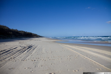
Bagdad Beach is located 40 km. East of Matamoros, it is a "clean and flat" beach, ideal for fishing and water sports, its large dunes allow us to enjoy an extreme adventure.
In the period of Easter, weekends, and in summer holidays, locals and visitors enjoy the good weather, soft sand and gentle breezes.
The influx of visitors come mainly from the state of Nuevo León, San Luis, Coahuila and lovers of sport fishing. It is considered a tourist area with great potential due to its natural beauty.
Weather conditions are mostly sunny. https://conocematamoros.com/sol-y-playa
Cross House
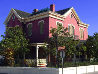
This home is perhaps one of the most beautiful buildings in Matamoros. Its architecture is Colonial French and the materials used to build it were brought from New Orleans. It is the only of its kind in northeastern Mexico and tastefully furnished, in addition to several musical instruments and library. After many years of neglect, it was restored in 1982.
An American farmer named John Samuel Cross, originally from South Carolina, fell in love with a mulatto slave from Martinique named Elisa Foyé. For this reason his father disinherited him; leaving him only five dollars, a horse and a gun. John S. Cross was travelling along the coast arriving first to New Orleans and later he moved to Texas towards the middle of 1850. From this beautiful relationship they had seven children, including Melitón.
Over time, he acquired vast properties in Brownsville and Matamoros. He made his fortune and climbed into the highest levels of society. 38 years after escaping with his wife, Elise Foyé, she died in 1886. 3 years later he married María de Jesús Santellana.
Several years later his son Melitón Cross, was the one who built the residence where he lived with his wife and daughters until his death. Upon the death of its owners, this building fell into disrepair. In 1982 Filemón Garza acquired this residence, rebuilding it according to its original state.
https://conocematamoros.com/casa-cross
Casamata Museum
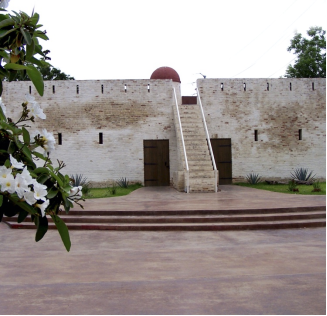
With its unique architectural structure, El Fuerte Casamata is a unique and relevant monument to military architecture in the country. Its name comes from the Latin word Casa Armata, which means Armed House.
Its construction began in the year 1845 and it took 30 years to finish it; counting on an extensive defense device of the City of Matamoros in the XIX century. Later it was used as a barracks, family dwelling, tannery, among others.
Due to its characteristics, in 1986 it was registered in the National Catalog of Historical Monuments of the INAH which is in charge of the conservation and restoration of historical and artistic monuments of the Republic.
Its objective is to publicize the historical events that had an impact on the development of the northern part of the state of Tamaulipas through photographs, documents and objects of famous people such as Don Benito Juárez and Francisco Villa. In addition, it has a collection of pre-Hispanic pieces and typical musical instruments from the Huasteca region.
From those trenches, moats and fortifications survives Fort Casemate, a restored construction that houses a fundamental vision of the past of this city and that today reappears as a contemporary cultural space.
https://conocematamoros.com/museo-casamata
6. History
Prehispanic history
There is very little historical evidence about the native tribes that lived in present-day Matamoros. As with many parts of northern Tamaulipas, the region of Matamoros was most likely occupied by small, indigenous groups from Coahuila, before the colonization by the Spanish colonials.
Foundation
In the year 1519, the same year that Hernán Cortés arrived to the Americas at the port of Veracruz,[34] a captain named Alonso Álvarez de Pineda carried out a brief expedition to the region of northern Tamaulipas, where he named the town known today as Rio Bravo (Rio Grande) as Rio de las Palmas (Palms River).[35] Nevertheless, the actual founding of Matamoros began in 1686, when Captain Alonso de León explored the area and concluded that the Rio Grande was an excellent route for navigation, and that the area of Matamoros was an ideal spot for cattle raising.
In the year 1749, thirteen enterprising families, twelve from Camargo and one from Reynosa, decided to invest and begin a new, influential cattle industry in the area.[37] Former landowners were reluctant that this new investment would be successful, since the frequent overflows from the Rio Grande caused severe floods, and because ranches were occasionally attacked by Indians. Nonetheless, these thirteen families effectively carried out their business plan and structuralized 113 cattle-raising sites. In the year 1774, they officially named the area San Juan de los Esteros Hermosos, known today as Matamoros.
In 1793, to colonize the province of Nuevo Santander, two Franciscan missionaries named Francisco Pueyes and Manuel Júlio Silva established a parish in the main plaza of Matamoros. They proposed a new name for the community: Villa del Refugio, in honor of the parish and patron saint, Our Lady of the Refuge of the Estuaries.
Mexican independence
In 1826, the governor Lucas Fernandez dispatched a decree to change the name of the city to Matamoros, in honor of Mariano Matamoros, a hero of the Mexican War of Independence who participated along with José María Morelos. During the Texas Revolution (1836), Matamoros was the fortress for many Mexican soldiers against rebel attacks. In 1851, the city of Matamoros was again heroic for defending soldiers against attacks, and the troops of Francisco Avalos were able to repel their enemy.
After that victory, the state congress granted Matamoros the title of "Heroic", countersigned by the Mexican Congress.
The future of the city radically changed after Matamoros declared itself an international free trade zone in 1858. This transformation brought upon urbanization, industrialization, and the expansion of the Bagdad Port, which experienced an economic boom for being the only entrance port for mercenaries for the Confederate States of America during the American Civil War.[45] The Port of Matamoros, also known as the Port of Bagdad, was during the American Civil War one of the leading commercial ports of the world.
Texas Revolution
The city of Matamoros, Tamaulipas was a strategic and fortified city during the Texas Revolution. The Matamoros Expedition was launched to attack Matamoros and defeat the forces of Antonio López de Santa Anna. It proved controversial and divisive. The roots of the controversy lay in the division within the provisional government between Governor Henry Smith and the General Council over whether to remain loyal to the Constitution of 1824 and support the liberals of Mexico in the Federalist cause against Santa Anna or to declare independence from Mexico and seek to become an independent territory. The division, on the other hand, was mirrored within the provisional government and among the commanders in the field, who compounded the situation and contributed to the near destruction of the Texan army.
The city of Matamoros, Tamaulipas was a strategic and fortified city during the Texas Revolution. The Matamoros Expedition was launched to attack Matamoros and defeat the forces of Antonio López de Santa Anna. It proved controversial and divisive. The roots of the controversy lay in the division within the provisional government between Governor Henry Smith and the General Council over whether to remain loyal to the Constitution of 1824 and support the liberals of Mexico in the Federalist cause against Santa Anna or to declare independence from Mexico and seek to become an independent territory. The division, on the other hand, was mirrored within the provisional government and among the commanders in the field, who compounded the situation and contributed to the near destruction of the Texan army.
American Civil War
At the beginning of the American Civil War, the city of Matamoros was simply a sleepy little border town across the Rio Grande from Brownsville. It had, for several years, been considered a port, but it had relatively few ships arriving. Previous to the war, accounts mention that not over six ships entered the port each year. Nevertheless, in about four years, Matamoros, due to its proximity to Texas, was to assume state as a port, and multiply its inhabitants in number. Following is a quote from a Union General in 1865 describing the importance of the port in Matamoros:
Matamoros is to the rebellion west of the Mississippi what New York is to the United States—its great commercial and financial center, feeding and clothing the rebellion, arming and equipping, furnishing it materials of war and a specie basis of circulation that has almost displaced Confederate paper ... The entire Confederate Government is greatly sustained by resources from this port.
The cotton trade brought together in Bagdad, Tamaulipas and Matamoros over 20,000 speculators from the Union and the Confederacy, England, France, and Germany. Bagdad had grown from a small, seashore town to a "full-pledge town". The English-speaking population in the area by 1864 was so great that Matamoros even had a newspaper printed in English—it was called the Matamoros Morning Call. In addition, the port exported cotton to England and France, where millions of people needed it for their daily livelihood, and it was possible to receive fifty cents per pound in gold for cotton, when it cost about three cents in the Confederacy, "and much more money was received for it laid down in New York and European ports". Other sources mention that the port of Matamoros traded with London, Havana, Belize, and New Orleans. The Matamoros and New York City trade agreement, however, continued throughout the war and until 1864, and it was considered "heavy and profitable".
By 1865, Matamoros was described as a prosperous town of 30,000 people, and Lew Wallace informed General Ulysses S. Grant that neither Baltimore or New Orleans could compare itself to the growing commercial activity of Matamoros. Nevertheless, after the collapse of the Confederacy, "gloom, despondency, and despair" became evident in Matamoros—markets shut down, business almost ceased to exist, and ships were rarely seen. "For Sale" signs began to sprout up everywhere, and Matamoros returned to its role of a sleepy little border town across the Rio Grande.
The conclusion of the American Civil War brought a severe crisis to the now abandoned Port of Bagdad, a crisis that until this day the port has never recovered from. In addition, a tremendous hurricane in 1889 destroyed the desolated port. This same hurricane was one of the many hurricanes during the period of devastating hurricanes of 1870 to 1889, which reduced the population of Matamoros to nearly half its size, mounting with it another upsetting economic downturn.
During the French Intervention, Port Baghdad was the scene of the Battle of Baghdad, where the Mexican Army defeated the French Army and its conservative allies.
During the course of the Mexican Revolution, General Lucio Blanco and Colonel Francisco J, Mújica executed the first agrarian distribution in the country, in August (1913). In February and April 1915, Matamoros was attacked by Villista generals Absaul Navarra and José E. Rodríguez, the defense being carried out by Sinaloan general Emiliano P. Nafarrate.
The following years were prosperous for Matamoros, where they enjoyed another golden period during the cotton era, which lasted from 1948 to 1963. At this time, Matamoros ranked as the largest producer and exporter of cotton in the entire state of Tamaulipas and the entire country. Approximately in 1970 the Ladrillera House was built, located on Div. Del Norte de la col. Guillermo Guajardo. In this building, bricks were made and stored inside. Since the 70s, and especially during the 90s, after the initiation of the North American Free Trade Agreement, foreign investment multiplied in Matamoros, resulting in great population growth, with inhabitants residing, mostly , from the states of San Luis Potosí and Veracruz.
7. Contact Information
City Mayor: Mario Alberto López Hernández

Contact number: +52 (868) 810 8000
Govt. Office Address: Sexta S/N, González y Morelos, Centro, Heroica Matamoros, Tamaulipas, México
FB: https://www.facebook.com/mariolopezlaborre
Twitter: https://twitter.com/MarioLopezBorre
Website: https://www.matamoros.gob.mx
