Pachuca, Hidalgo 作者: 来源: 发布时间:2021-07-22
1.Population and Area
Pop: 277,375
Area: 154.1 km2 (city)
Elev: 2,432 masl
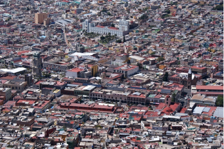
2. Natural geography
Nature and weather
It is located within the physiographic province of the Neovolcanic Axis, within the subprovinces of Llanuras and Sierras de Querétaro and Hidalgo (53.28%) and Lagos and Volcanes de Anáhuac (46.72%). As for edaphology to the south there is phaeozem soil, chernozem to the north and lithosol to the west. Regarding geology, there are rocks from the neogene period (48.5%) and quaternary period (7.26%) mainly and of the extrusive igneous type.
In terms of land relief, it is made up of obvious contrasts, to the north there are mountainous areas, as well as hills in the northwest-southwest part and plains that extend from the central portion to the south. Its territory is made up of plains in 36.13% of its territory, with hills in a 10.59% and of sierra the remaining percentage of 53.28%.
Regarding hydrography, it is within the hydrological region of the Pánuco river in the Moctezuma river basin; within the sub-basins of the Tezontepec River (84.78%), Actopan River (13.75%) and Amajac River (1.47%). The Río de las Avenidas, is a natural channel of eventual use to contain torrents on days of higher rainfall and used as a collector for sewage drains; that crosses the city from north to south. It is born in the Sierra de Pachuca and extends towards Tizayuca and empties into the Grand Canal del Desagüe.
As for the flora; Around the city you can only find vegetation corresponding to the xerophilous scrub, there are abundant species such as agave lechuguilla, burro chiche biznaga (Coryphantha pycnacantha), Wavy Flat Thorns biznaga (Stenocactus phyllacanthus), palo loco (Senecios praecox), cardón nopal ( Opuntia streptacantha), squirrel nopal (Opuntia spinulifera), camueso nopal (Opuntia robusta), pirul (Schinus molle), cardón (Cylindropuntia imbricata), white grass (Zaluzania augusta), among others. Regarding the fauna, find the cacomixtle, gophers, field mice, armadillos, squirrels. As for the birdlife, there are the Mexican finch (Haemorhous mexicanus), the long-tailed turtle (Columbina inca), and the curved-billed cuitlacoche (Toxostoma curvirostre).
In Pachuca there is a total area of green areas of 490,407.07 m²; which are distributed in twenty-four parks with 194 525.84 m², seven gardens with 15 700.97 m², seven squares 44 771.90 m², three sports units 203 136.47 m² and others with 32 271.89 m².99 One of the most important parks in the city is the Hidalgo Park; In 1885 it was inaugurated under the name of “Parque Porfirio Díaz”, on June 14, 1911 it changed the name to “Parque Hidalgo.” The Biopark of Coexistence Pachuca, founded in 1978; is a park dedicated to the recovery and rescue of animal species at risk and in serious conditions of abuse and neglect.
Other important public parks in the city are the Family Park, Pasteur Park, the Children's Heroes Garden, the Teacher's Garden and the Art Garden. In the city is the Cubitos Ecological Park, which was declared a state park on December 30, 2002, covering an area of 90.45 ha; It has an ecological house, the tuzuario, the herpetarium, interactive farm, biopreservation area, a botanical garden, a labyrinth, an arboretum, seventeen nurseries, a zip line, an eco-games area, a bicycle path, roads. They find the Center for Environmental Education and Training, the Forest Germplasm Bank, the State Center for Environmental Surveillance and Analysis and the Laboratory Center for Atmospheric Monitoring System Service. A set of cultural activities related to environmental sustainability, the management and recycling of garbage are developed in the park.
Another protected area in the city is the Cerro del Lobo Ecological Preservation Zone; decreed on July 18, 1988, this area comprises 25.85 ha. Within the limits of Pachuca there are some geosites of the Comarca Minera Geopark, these are the Cerro de San Cristóbal, the Cristo Rey, the Cubitos tobaceous deposits, the La Purísima, the Cerro del Lobo Viewpoint, as well as the Mineralogy Museum and the Monumental Clock.
Köppen Classification: Oceanic Subtropical Highland Climate
The subtropical highland variety of the oceanic climate exists in elevated portions of the world that are within either the tropics or subtropics, though it is typically found in mountainous locations in some tropical countries. Despite the latitude, the higher altitudes of these regions mean that the climate tends to share characteristics with oceanic climates, though it also tends to experience noticeably drier weather during the "low-sun" season. In locations outside the tropics, other than the drying trend in the winter, subtropical highland climates tend to be essentially identical to an oceanic climate, with mild summers and noticeably cooler winters, plus, in some instances, some snowfall. In the tropics, a subtropical highland climate tends to feature spring-like weather year-round. Temperatures here remain relatively constant throughout the year and snowfall is seldom seen.Without the elevation, many of these regions would likely feature either tropical or humid subtropical climates.
The Köppen Climate Classification subtype for this climate is "Cwb". (Oceanic Subtropical Highland Climate).
The average temperature for the year in Pachuca is 57.2°F (14°C). The warmest month, on average, is May with an average temperature of 61.9°F (16.6°C). The coolest month on average is January, with an average temperature of 52.3°F (11.3°C).
The highest recorded temperature in Pachuca is 104.0°F (40°C), which was recorded in April. The lowest recorded temperature in Pachuca is 15.8°F (-9°C), which was recorded in January.
The average amount of precipitation for the year in Pachuca is 15.4" (391.2 mm). The month with the most precipitation on average is June with 2.9" (73.7 mm) of precipitation. The month with the least precipitation on average is February with an average of 0.2" (5.1 mm). In terms of liquid precipitation, there are an average of 80.3 days of rain, with the most rain occurring in July with 12.6 days of rain, and the least rain occurring in December with 1.9 days of rain.
Getting there and around
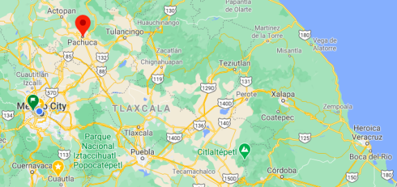
Get there
By plane - Pachuca is serviced by Mexico City International Airport. There is a comfortable shuttle bus which can be boarded directly from the airport, giving hourly service to and from Pachuca. Depending on traffic conditions, it takes about an hour or two to arrive at this town.
By car - Pachuca is about 90 km (56 miles) north of Mexico City. The road is flat with very few curves. Because it is a toll-highway, it's usually in good conditions.
By bus - Pachuca is easy to reach by first class bus from several cities in the region, including from Mexico City's North station and Puebla's CAPU station (~2 hr, M$ 200). From the bus station, take a taxi or one of the combi minivans (M$ 7.5) to get to the old city center.
Car Rental – To explore Mexico’s provincial towns and cities—including its beach locations and the scenery and attractions near them— consider renting a car for your visit. Having your own car will give you more flexibility than using public transport options and, in some cases, offer you access to places which are otherwise difficult to visit without the use of a car.
Get around
Local Buses – Local buses and mini-buses (combis or micros) are available locally for a fraction of the cost of a taxi around town. You need to speak Spanish to be able to ask for directions or ask the driver to tell you where to get off.
Taxis – Taxis in most of Mexico’s towns and cities are not metered, so agree your price before you get in. Taxi travel is very affordable in Mexico, in comparison to the USA, Canada and Europe, and so provides a viable means of public transportation in Mexico. Your hotel can arrange taxis for you; some post their rates on a board in the lobby; taxi hotel rates are usually higher than cabs you hail off the street. If you speak Spanish, you will have a distinct advantage and be able to negotiate a price with the driver.
Uber is expanding rapidly across Mexico and now offers services in cities across the country, including: Mexico City, Toluca, Cuernavaca, Puebla, Querétaro, León, Aguascalientes, San Luis Potosí, Guadalajara, Monterrey, Hermosillo, Tijuana, Mexicali, and Mérida. Uber has been adding Mexican cities to its network every year, check for availability when you arrive at your destination in Mexico.
Cabify is developing also and currently operates in cities including Mexico City, Toluca, Monterrey, Puebla, Querétaro and Tijuana. Check for availability in the city you are visiting.
The services offers people with smartphones a way to book a cab through a mobile app for a pre-agreed price. Fares are comparable with Sitio type cabs (see above), and sometimes trade at a premium to this when local demand increases.
https://www.mexperience.com/transport/taxi-travel-in-mexico/#51
3. GDP
GDP: 18000 M MXN (2012)
4. Industry characteristics
Characteristics
Despite its decline in the 20th century, mining still continues to be an important element of Pachuca's economy. Pachuca still produces more than 60% of the state's gold and more than 50% of its silver. The Mexican Geological Survey is headquartered in the city.
The manufacturing sector was established in the 1950s and has been steadily growing, changing the city's traditional mining image. Some of the major industrial employers are Applied Power de México (automotive parts), BARROMEX (machinery), Herramientas Cleveland (machinery and tools) and Embotelladora la Minera (soft drinks). The city also contains over 800 smaller manufacturing enterprises.
The municipality's economy also has a large commercial sector, with numerous stores and thirteen public markets. It is also the wholesale center for foodstuffs for most of the state.
Despite all the changes in the 20th century, the center of Pachuca has maintained its provincial feel. This has led the city to promote it as a tourist attraction.
In Pachuca, it is estimated that the tourism sector contributes 4.85% of GDP.9 In 2015 the tourism infrastructure it has is as follows: 24 hotels, four motels, a guest house, 101 restaurants, 18 coffee shops, and 19 bars.
5. Attractions
Monumental Clock Park
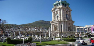
The monument was inaugurated on the centennial anniversary of Mexico’s independence from Spain on September 15, 1910. It was the brainchild of then governor, Pedro L. Rodríguez. At the urging of several residents, the initial plan was to erect a kiosk to showcase local bands, but the governor decided instead to commemorate the milestone in Mexico’s history.
Located in Pachuca’s main square, formerly known as “Plaza de Las Diligencias”, the structure stands 40 meters high and is fashioned in Neoclassical architecture with four levels in all. The entire structure, excluding the top copper cupola, is constructed of cantera blanca stones which were quarried locally in the area of Tezoantla. The stones were assembled using the “machi-hembrada” technique which features a Lego-like design incorporating “male/female” pieces, obviating the need for any mortar and instead relying on the natural weight of the structure for reinforcement.
For the top portion, the cupola is framed in steel which was fabricated in Monterrey and brought by rail to the location. It’s covered in copper and is identical on all four sides, except for the statues found on the exterior. Here, each side displays a 3-meter tall female statue made of Carrara marble and an accompanying date representing unique points in Mexico’s history. Over each statue there is also an eagle with a spread wingspan that achieves the continuity in placement of the Mexican national symbol.
http://mexicounmasked.com/el-reloj-monumental-a-symbol-of-timeless-reflection-in-pachuca
Mining Museum
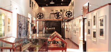
A region whose modern history is closely linked to mining activity, this museum tells an important part of regional history through its mining history using images, documents, tools, furniture and more. The building dating from the late nineteenth century, is also the Historical Archives of the Royal Company of Monte and Pachuca. Rooms for temporary exhibitions, do not stop checking their exhibitions.
The museum consists of the areas: Geology: Stone Age / Obsidian / Pre-Hispanic Metallurgy; Novohispano Period; Company of the English Adventurers; Aviator Society. In the main gallery the North American Period is distributed along with the Parastatal.
https://www.zonaturistica.com/en/things-to-do/hidalgo/pachuca/the-mining-museum
Football Museum and FIFA Hall of Fame
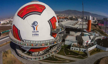
This is the official Hall of Fame of the International Football Federation (FIFA), which hosts an exhibition of the trajectories and accolades of those selected to form part of the Hall of Fame, among other activities related to the World’s most popular sport.
On the first floor, there are designs for temporary exhibitions of the ceremonies that this venue has had. On the second floor, there are the National Hall, as well as the International, photo galleries, interactive tables, conference panels and the most relevant data of the World Cups played. On the third floor there is a 360-degree screen illustrating the trajectory of those invested.
The director of this is Antonio Moreno, a sports journalist, and the investiture vote is done through an honor committee and a select group of journalists.
http://www.salondelafamadelfutbol.com/
Pachuca Club games
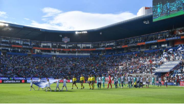
The Cornish miners of Pachuca are credited with bringing soccer to the Americas when they formed the original Pachuca league. These days, the town’s soccer team is one of the best in Mexico, and it would be a shame for any fan to pass up seeing them live. The Liga MX has a two-tournament season, one of which starts at the beginning of summer and one at the beginning of winter, meaning that any time you head to Pachuca, you are most likely going to be able to see a game.
6. History
Evidence of early human habitation in this area is found in Cerro de las Navajas and Zacualtipán, in the Sierra de Pachuca. Here primitive mines to extract green obsidian, arrow heads, scraping tools, and mammoth remains can be traced back as far as 12,000 BCE. An ancient pre-Hispanic obsidian tool-making center has also been found in the small town of San Bartolo near the city. Around 2,000 BCE nomadic groups here began to be replaced by sedentary peoples who formed farming villages in an area then known as Itzcuincuitlapilco, of which the municipality of Pachuca is a part. Later artifacts from between 200 CE and 850 CE show Teotihuacan influence with platforms and figurines found in San Bartolo and in Tlapacoya. Development of this area as a city, however, would lag behind other places in the region such as Tulancingo, Tula and Atotonilco El Grande, but the archeological sites here were on the trade routes among these larger cities.
After the Teotihuacan era, the area was dominated by the Chichimecas with their capital in Xaltocan, who called the area around Pachuca Njunthé. Later, the Chichimecas would found the dominion of Cuauhtitlán pushing the native Otomis to the Mezquital Valley. These conquests coalesced into a zone called Cuautlalpan, of which Pachuca was a part. Fortifications in the area of Pachuca city and other areas were built between 1174 and 1181. This dominion would eventually be overrun by the Aztec Triple Alliance between 1427 and 1430, with rule in Pachuca then coming from the city of Tenochtitlan. According to tradition, it was after this conquest that mineral exploitation began here and in neighboring Real del Monte, at a site known as Jacal or San Nicolás. The Aztec governing center was where Plaza Juárez in Pachuca city is now.
The Spanish arrived here in 1528, killing the local Aztec governor, Ixcóatl. Credit for the Spanish conquest of the Pachuca area has been given Francisco Téllez, an artilleryman who came to Mexico with Hernán Cortés in 1519. He and Gonzalo Rodriguez were the first Spaniards here, constructing two feudal estates, and calling the area Real de Minas de Pachuca. Téllez was also given credit for laying out the colonial city of Pachuca on the European model but this story has been proven false, with no alternative version. Mining resources were not discovered here until 1552, and there are several versions of this story. The most probable comes from a work called “Descripción Anónima de la Minas de Pachuca” (Anonymous Description of the Mines of Pachuca) written between the end of the 16th century and the beginning of the 17th. This work claims that the first mineral deposits were found by Alonso Rodríguez de Salgado on his ranch on the outskirts of Pachuca in two large hills called Magdalena and Cristóbal. This discovery would quickly change the area's economy from agriculture to one dependent almost completely on mining.
As early as 1560 the population of the city had tripled to 2,200, with most people employed in mining in some way. Because of this rapid growth and the ruggedness of the terrain, it was impossible to lay out an orderly set of streets. The first main plaza was placed next to the Asunción Parish, which is now the Garden of the Constitution. Next to the Cajas Reales (Royal Safe) was constructed to guard the fifth that belonged to the king.
In 1554, on the Purísima Concepción Hacienda, now the site of a tennis club, Bartolomé de Medina found the largest mineral deposits here as well as developed new ways of extracting minerals from ore using the patio process. This caused Pachuca to grow even more with the discovery of new deposits and accelerated extraction processes. Mining operations spread to nearby areas such as Atotonilco, Actopan, and Tizayuca. The population of the town continued to grow, leading Pachuca to be declared a city in 1813.
Mining output had waned by the 18th century due to flooding, but was revived in 1741 by the first Count of Regla, Pedro Romero de Terreros, and his business partner Jose Alejandro Bustamante, who invested in new drainage works. He also discovered new veins of ore, mostly in nearby Real del Monte. By 1746, Pachuca had a population of 900 Spanish, mestizo, and mulatto households, plus 120 Indian ones.
During the Mexican War of Independence, the city was taken by Miguel Serrano and Vicente Beristain de Souza in 1812, which caused the mines here to be abandoned by owners loyal to Spain. The war left the Pachuca area in a state of chaos, both politically and economically. The third Count of Regla brought the first Cornish miners and technology around 1824. The Cornish took over mines abandoned by the Spanish, bringing 1,500 tonnes of more modern equipment from Cornwall. Cornish companies eventually dominated mining here until 1848, when the Mexican–American War forced them to sell out to a Mexican company by the name of Mackintosh, Escondón, Beistegui and John Rule. Mining operations resumed in 1850, especially in the Rosario mine.
Mining operations were disrupted again by the Mexican Revolution in the early 20th century. The city was first taken by forces loyal to Francisco I. Madero in 1911. Roberto Martinez y Martinez, a general under Pancho Villa, entered the city in 1915. Both incursions were due to the economic importance of the mines here.[5] During this time American investors came to Pachuca, again updating the mining technology used here. From 1906 to 1947 the United States Smelting, Refining and Mining Company was the primary producer here, with output reaching its peak in the 1930s. However, by 1947, mining here had become too costly, because of political instability, labor disputes and low prices for silver on the world market. The company sold its interests to the Mexican government in 1965.
The decline in mining here in the mid-20th century had disastrous effects on the city. Many of the abandoned houses and other buildings were in danger of collapse. Under ownership of the Mexican government, mining came to a near standstill. During this time Pachuca's economy began to shift from mining to industry. The old Instituto Científico Literario Autónomo de Hidalgo was converted to the Universidad Autónoma del Estado in 1961, which would become one of the impetuses to the growth of the city in the following years, turning out as it did a better-educated and more technical workforce in areas such as law, engineering, business and medicine. In the late 1950s and through the 1960s, some growth was seen in the way of suburban developments for workers in newly built factories.
Population growth returned in the 1970s and continued through the 1990s because of the growth of non-mining industries as well as a development of a large student population for the state university as well as other educational institutions. Another impetus was the movement of many government offices to Pachuca with new government facilities such as the State Government Palace and the State Supreme Court built in the 1970s. Much of the city's growth during this time was due to new housing projects, but infrastructure projects such as the new Municipal Market, the remodeling of the Plaza Benito Juárez and the main bus station also took place.
7. Other information
Pastes (Pastys)
A paste (Spanish: [ˈpaste]) is a small pastry produced in the state of Hidalgo in central Mexico and in the surrounding area. They are stuffed with a variety of fillings including potatoes and ground beef, apples, pineapple, sweetened rice, or other typical Mexican ingredients, such as tinga and mole. The paste has its roots in the Cornish pasty introduced by miners and builders from Cornwall, United Kingdom who were contracted in the towns of Mineral del Monte (Real del Monte) and Pachuca in Hidalgo starting in 1824.
Unlike empanadas, the filling ingredients for pastes are not cooked before they are wrapped in the pastry casing. Additionally, while empanadas are a light, flaky, leavened pastry containing several layers of dough, pastes use a firm and thin layer of dough.
The Festival Internacional del Paste is held in Real del Monte for three days each October.
8.Contact Information
City Mayor: Yolanda Tellería Beltrán

Contact number: +52 (449) 717 1500
Govt. Office Address: Plaza General Pedro Ma. Anaya No.1 Col. Centro, CP. 42000 Pachuca Hidalgo
FB: https://www.facebook.com/yolitelleriamx
Twitter: https://twitter.com/yolitelleria
Website: https://www.pachuca.gob.mx/lacasadetodos
