Zacatecas city, Zacatecas 作者: 来源: 发布时间:2021-07-22
1.Basic data
Pop.: 138,152
Area: 356.14 km2
Elev.: 2,440 masl
2. Natural geography
The municipality is wedged between the Sierra Madre Occidental and the subrange called Sierras y Valles Zacatecanos. The area is very rugged terrain filled with narrow valleys, ravines and mountains. The principal elevations include Cerro El Grillo at 2,690 m (8,830 ft), Cerro Los Alamitos at 2,680 m (8,790 ft), Cerro La Bufa at 2,650 m (8,690 ft), Cerro La Mesa at 2,590 m (8,500 ft), Mesas El Rincón Colorado at 2,540 m (8,330 ft), Cerro La Mesa at 2,440 m (8,010 ft) and Cerro Grande at 2,370 m (7,780 ft). The area is divided between the Lerma River and El Salado River basins, with a large number of small streams and arroyos crossing the territory.
The main wild flora species found in the municipality are: Cardón Nopal, Duraznillo Nopal, Creeping Nopal, Cardenche, Mesquite, Huisache, Pirul, Navajita Grass, Palm, Poplar, Willow, Garabatillo, Maguey, Fattening Goat and Bisnaga. It is worth mentioning that the original vegetation of the municipal seat consisted of pines and oaks, which was quickly lost, this fact is recorded in the early seventeenth century by Don Alonso de la Mota y Escobar, Bishop of New Galicia.
Regarding its fauna, the main species that occur in the municipality are: Coyote, gray fox, wild cat, opossum, hare, rabbit, field rat, techalot, squirrel, gopher, raccoon, skunk, huilota pigeon, wing pigeon white, sparrow, crow, aura, pitacoche, red mullet, swallow, mound, kestrel, red-tailed hawk, and wild duck.
Weather
Köppen Classification: Tropical and Subtropical Steppe Climate
This climate type occurs primarily on the periphery of the true deserts in low-latitude semiarid steppe regions. It is transitional to the tropical wet-dry climate on the equatorward side and to the mediterranean climate on its poleward margin, with a cooler, wetter winter resulting from the higher latitude and mid-latitude frontal cyclone activity. Annual precipitation totals are greater than in tropical and subtropical desert climates. Yearly variations in amount are not as extreme as in the true deserts but are nevertheless large.
The Köppen Climate Classification subtype for this climate is "BSk". (Tropical and Subtropical Steppe Climate).
The average temperature for the year in Zacatecas is 57.0°F (13.9°C). The warmest month, on average, is May with an average temperature of 63.0°F (17.2°C). The coolest month on average is January, with an average temperature of 50.0°F (10°C).
The highest recorded temperature in Zacatecas is 96.8°F (36°C), which was recorded in May. The lowest recorded temperature in Zacatecas is 12.2°F (-11°C), which was recorded in December.
The average amount of precipitation for the year in Zacatecas is 8.9" (226.1 mm). The month with the most precipitation on average is August with 2.6" (66 mm) of precipitation. The month with the least precipitation on average is February with an average of 0.1" (2.5 mm). In terms of liquid precipitation, there are an average of 56.0 days of rain, with the most rain occurring in July with 10.1 days of rain, and the least rain occurring in March with 1.0 days of rain.
https://www.weatherbase.com/weather/weather-summary.php3?s=52567&cityname=Zacatecas%2C+Zacatecas%2C+Mexico&units=
Getting there and around
By plane
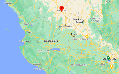
You can take a direct flight to the Zacatecas International Airport (ZCL) from Mexico City and Tijuana. Direct flights also exist to the U.S. cities of Los Angeles, Chicago, Dallas-Fort Worth, and Houston. Once at the airport just take a 20 min. taxi ride to downtown.
By bus Most major cities offer direct buses to Zacatecas (usually operated by either Omnibus de México, Estrella Blanca, or their affiliates) especially those cities located in Northern Mexico. If you are traveling by bus from Southern Mexico you may have to make a connection in Mexico City. There are also buses that run from Zacatecas to the US (mainly Texas) operated by companies such as Autobuses Americanos, Omnibus Mexicanos, and Turimex Internacional. The Central Camionera (bus station) is on a hilltop a bit out of town. The taxi ride into town will cost roughly around 35 pesos.
By car from the south, you can take Hwy. 45D, a toll road, from Querétaro through Irapuato, León, and Aguascalientes (a 6-hr. drive). It's expensive (about 300 pesos) but relatively fast. Hwy. 54 heads northeast to Saltillo and Monterrey (a 5- to 6-hr. drive) and southeast to Guadalajara (a 4 1/2-hr. drive). Hwy. 49 leads north to Torre√≥n (4 hr.) and southeast to San Luis Potosí (3 hr.). Hwy. 45 heads to Durango (4 hr.).
From Abroad Arrive to Mexico City International Airport, then you can either take a bus or jump on another plane.
Get around
Walking is probably the best way to get around the Centro Historico (Historic Downtown) which is relatively small. It will allow you to see the city at your own pace. Note that the elevation of the Centro is about 8000 feet (2400 meters) while surrounding portions of the city are much higher. Be sure that you are acclimated to the altitude.
If you get tired, take a taxi cab or an UBER. They are moderately priced and available all over the city. If taking a taxi cab ask the driver in advance how much he will charge you for the trip (Cuanto cuesta ir a 'Insert place name'?). As most prices in Mexico, taxi fares are open to negotiation and asking in advance should reduce uncertainty and give you a better negotiating position.
There is also the Maxibus and Tren Zacatecano which will drive you around the city to show you the interesting sites. Both cost 40 pesos for adults and 30 for reductions, last about 45 minutes and leave from the Plaza de Armas.
https://trip101.com/article/things-to-do-in-zacatecas-mexico
3. Economy
GDP: 10740.4 M MXN
4. Industry
There is no information available about the economy at municipal level in Zacatecas, but the Zacatecas City contributes with most of the state’s GDP.
As in the past, the state's dominant sector is mining, accounting for 13% of the state's GDP and .9% of the entire country's. The state is rich in mineral wealth include lead, zinc and copper with small quantities of gold and silver, along with non-metal mineral deposits such as kaolinite, wollastonite, fluorite and barite. The state has fifteen mining districts of which the most important are Fresnillo, Zacatecas, Concepción del Oro, Sombrerete and Chalchihuites, along with Nora de Angeles more recently. Zacatecas accounts for 21% of the country's gold production and 53.2% of its silver. Two of the largest silver mines in the world currently are operated in Zacatecas: former Peñoles subsidiary Fresnillo's Mina Proaño (also known as the Fresnillo Silver Mine), and the Peñasquito Polymetallic Mine. Zacatecas silver mostly accounts for Mexico's status as the world's largest producer of silver, accounting for 17% of the world's output.
Zacatecas's economy used to be almost completely centered on mining but has since diversified into cattle raising, agriculture, communications, food processing, tourism and transportation. Zacatecas is Mexico's main producer of beans, chili peppers, guavas and nopal, along with significant grain, sugar cane, grape and peach crops. It is also a major producer of rum, pulque and mezcal and even produces red wine. These activities account for just over ten percent of the state's GDP.
Manufacturing accounts for over twelve percent of the state's GDP and has attracted most of the state's foreign investment. Traditional handcrafts include weaving in Villa Garcia, saddles and jewelry in Jerez as well as furniture, leatherworking, miniatures, macramé, ironwork and pottery in various locations.
Tourism includes the capital along with the designation of "Pueblos Mágicos" such as Jerez, Teul de Gonzalez Ortega and Sombrerete, along with the shrine of the Santo Niño de Atocha, which is visited by thousands every year. It also includes archeological sites such as Alta Vista and La Quemada along with thermal springs such as Paraíso Caxcan.
Commerce and services accounts for over 53% of the GDP, mostly small scale operations.
5. Touristic sites
Colonial Downtown
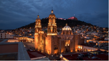
The Plaza de Armas (main square) is also host to the city’s cathedral, with its magnificent stone facade. You’ll also find the Palacio de Gobierno (Government Palace) building here, as well as the Residencia de Gobernadores (Governor’s Residence) and Palacio de la Mala Noche (Palace of the Bad Night), also known as the Palacio de Justicia (Palace of Justice).
The Mercado Gonzalez Ortega, previously the main marketplace in Zacatecas, has now been renovated into a modern up-market shopping center. You can also eat here at one of the several restaurants integrated within the building.
Mina El Edén
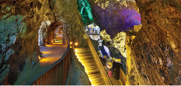
There’s an old Silver mine, called Mina El Eden, which is located inside the Cerro del Grillo, a major attraction of the city and an important historical landmark. There were originally seven levels in this mine; level four is open to visitors, and a train ride will take you deep into the hill which hosted it. The train stops inside, and you are guided down walkways deep into the mines, where you’ll begin to see the conditions that mind workers of the day endured to get gold, silver, iron, copper and zinc out of these rocks.
You can visit the interior of the mine in a picturesque train through tunnels and galleries, and inside there is a Museum that exhibits the history of the important mining activity in Zacatecas. The El Eden Mine is one of the most recommended places to visit.
https://www.mexperience.com/travel/colonial/zacatecas
https://www.zonaturistica.com/en/things-to-do/zacatecas/zacatecas/the-eden-mine
Cerro de la Bufa
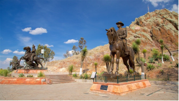
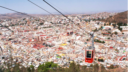
Cerro de La Bufa is the imposing mountain on the northeast side of the city. It’s up here that you’ll see magnificent views across the city, and further north, the vast expanse of arid desert that streams out from this ‘frontier capital’. To get to the top, you can drive there, but it’s best to take the Cable Car (Teleferico) which will transport you across a magnificent view of the city to the top of the mountain in just a few minutes. The Teleferico station is near the mine, so both are within easy access of each other.
The Cerro de la Bufa is 2,567 meters above sea level offering you one of the best views of the city and its tourist sites. His name was given by Juan de Tolosa and means in Aragonese 'pig bladder'. In 1914 he witnessed the last battle of the Revolution. You can go up to enjoy the beautiful view and take the opportunity to visit the chapel built in 1728, the Plaza de la Revolución Mexicana and the Observatory de la bufa, where you can see a real-time aerial tour of the metropolitan area of Zacatecas. The only observatory for tourist purposes in Mexico.
https://www.zonaturistica.com/en/things-to-do/zacatecas/zacatecas/bufa-hill
Zacatecano Museum
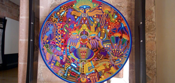
This building functioned as Casa de la Moneda from 1810, to later be the office of an English company and then government offices. Exactly two centuries later it turns into a museum. Since 2010, this place to visit has exhibited more than 150 pieces of Huichol art, with a 2.40mx 3m mural made entirely of beads. You will also find 70 images of the Huichol world, historical documents, coins and more.
In its permanent rooms it exhibits a collection of Huichol embroidery, contemporary Huichol art (mural made up of 80 pieces with more than two million beads), colonial ironworks from the 17th to the 19th centuries, popular religious altarpieces from the 19th century, numerous handicrafts and a series photographic about the Huichols taken in the 1940s by Juan Víctor Arauz.
https://www.zonaturistica.com/en/things-to-do/zacatecas/zacatecas/zacatecano-museum
http://sic.gob.mx/ficha.php?table=museo&table_id=657
6. History and Culture
Indigenous peoples
The first people to populate the area arrived approximately 10,000 years ago, when the climate was wetter and warmer, with different vegetation and wildlife. Eventually, the area came to be dominated by Chichimeca tribes such as the Caxcans, Guachichils, Guamares, Huichols, Zacatecos and others, with the Zacatecos being the most numerous in the area of the city today. These peoples were mining silver and other metals in the hills long before the Europeans arrived, making the area important in pre-Columbian times.
Colonial period
The Spanish came to the Zacatecas area via Guadalajara. In 1540, Nuño de Guzmán traveled from Mexico City conquering what are now the states of Michoacán and Jalisco. One of Guzmán's lieutenants, Cristóbal de Oñate, conquered the area around what is now Guadalajara. Another, Pedro Almindes Chirinos Peralmindes, went to explore the lands to the north, taking Zacatecas with little trouble but not knowing of the riches underneath the soil. And the area initially was simply frontier. Other expeditions followed, including one by Juan de Tolosa in 1546, who brought back rock samples from Cerro de la Bufa, which were determined to contain high concentrations of silver and lead. A mining camp was soon established at the foot of Cerro de la Bufa. The Zacatecos initially fought the permanent presence of the Spanish, but the mining potential of the area strengthened the Europeans’ resolve and the natives were defeated in the 1540s. Surveys of the other surrounding hills were undertaken by Tolosa, Diego de Ibarra, Baltasar Temiño de Bañuelos, Andrés de Villanueva and others.
A military mining camp was formally established in 1548 and called Minas de Nuestra Señora de Remedios. The first major vein of silver was found in 1548 in a mine called San Bernabé. This was followed by similar finds in mines called Albarrada de San Benito, Vetagrande, Pánuco and others. This brought a large number of people to Zacatecas, including craftsmen, merchants, clerics and adventurers. In 1550, royalty found its way to Zacatecas in the person of Leonor Cortés Moctezuma, the illegitimate daughter of conquistador Hernán Cortés and Isabel Moctezuma, daughter of the Aztec emperor. Doña Leonor married Juan de Tolosa. The settlement grew over the space of a few years into one of the most important cities in New Spain and the most populous after Mexico City. The camp became a parish in 1550, in 1585, then it was declared a city with the name of "Muy Noble y Leal Ciudad de Nuestra Señora de Zacatecas" (Very Noble and Loyal City of Our Lady of Zacatecas), receiving its coat of arms from Philip II of Spain at the same time. The success of the mines led to the arrival of indigenous people and the importation of black slaves to work in them. The mining camp spread southwards along the course of the Arroyo de la Plata, which now lies underneath Hidalgo Avenue, the old town's main road. Tall buildings were constructed along here due to the lack of flat area on which to build. The first house was supposedly built in 1547, just before the fortress and metal foundry. Hospitals and hospices were built in the 1550s.
Zacatecas was one of the richest states in Mexico. One of the most important mines from the colonial period is the El Edén mine. It began operations in 1586 in the Cerro de la Bufa. It principally produced gold and silver with most of its production occurring in the 17th and 18th centuries. Today, the opening of this mine is within the city limits and was closed to mining in 1960. It was reopened as a tourist attraction in 1975. By the end of the 16th century, the city was the second most important, after Mexico City, and the income its mines produced for the Spanish Crown made it one of the most powerful in Europe. Its importance was not only due to mining. Most of the monastic orders in New Spain eventually established monasteries, making Zacatecas an important center for evangelization. The Franciscans arrived in 1558, the Augustinians in 1576 and the Dominicans in 1604. Many of the missionary expeditions to what are now California and Texas came from this city.
Over the rest of the colonial period, the riches from the ground financed the building important religious and secular constructions. The peak of this construction occurred in the 18th century. One of these constructions is the Colegio de San Luis Gonzaga, which was established in 1796.
Mexican War of Independence
Ignacio López Rayón led a group of Mexican rebels capturing the city of Zacatecas on April 15, 1811, early in the fight for Mexican independence from Spain. Víctor Rosales and José María Cos were leaders of Hidalgo's rebellion. Shortly after Independence, the Mexican government established the city of Zacatecas as the capital of the newly formed state of Zacatecas.
19th century
In the mid-1820s, institutions such as the first opera house, first teachers’ college, the state treasury, the state supreme court and other institutions were founded in the city when the first state constitution was signed. The first newspaper in the state started circulation herein 1825. The municipality was established in 1825.
From the end of the War of Independence until nearly the end of the 19th century, liberals or federalists and conservatives, who favored centralized rule from Mexico City, battled for control of Zacatecas. In 1835, then-liberal Antonio López de Santa Anna defeated the troops of Francisco Garcia Salinas. During the Reform War, the city was taken by conservative general Miguel Miramón.
The first railroad connecting Zacatecas with Guadalupe was completed in 1880. Connections with Mexico City and El Paso by rail were established in 1884.
Mexican Revolution
During the Mexican Revolution, Zacatecas was the scene of the Battle of Zacatecas in 1914, pitting the rebel forces of Francisco Villa against the government forces of Victoriano Huerta. Zacatecas was the last stronghold of the Huerta forces, which the División del Norte arrived on June 19, 1914 from Torreón.
Taking the city would clear the way for Villa to proceed to Mexico City. Villa's forces were under the direct command of General Felipe Ángeles, and Huerta's forces were under the command of General Luis Medina Barrón. From the 19th to the 23rd, General Medina used a light beacon brought from the port city of Veracruz to light the hills at night looking for rebel positions. The battle began at 10:00 a.m. on the 23rd with rebel cannon fire. Over 22,000 rebel troops then approached the city from four directions, from the mountains known as La Bufa, La Sierpe, Loreto and La Tierra Negra. The battle continued until about 5:00 that afternoon, when Huerta's troops began to abandon their positions, and the División del Norte took the strategic hills of La Bufa and El Grillo, entering the city. The rebels sacked the city and destroyed a number of buildings. Battle casualties were about 5,000 for Huerta's troops and about 3,000 for the rebels. After the Mexican Revolution, the city of Zacatecas decided to revive the original seal granted to it by Philip II, and make it the seal of both the city and the state. It had been discarded after the War of Independence. The "Marcha Aréchiga" or "Marcha Zacatecas" written by Genaro Codina in the early 20th century, became the semi official anthem of the city and state.
20th century
The old Instituto de Ciencias was refounded as the Universidad Autónoma de Zacatecas in 1968, and an international airport was constructed in 1970.
The anniversary of the city had been celebrated on the day of the Virgin of Zapopan, who was the patron until 1975. Since then the patron has been changed to the Virgin del Patrocinio, who is celebrated on the same day. The city center was named a World Heritage Site in 1993. UNESCO's websites states the following as justification. "Founded in 1546 after the discovery of a rich silver lode, Zacatecas reached the height of its prosperity in the 16th and 17th centuries. Built on the steep slopes of a narrow valley, the town has views of the area. There are also several old buildings, both religious and civil. The cathedral, built between 1730 and 1760, dominates downtown. It is notable for its harmonious design and the Baroque profusion of its façades, where European and indigenous decorative elements are found side by side."
Zacatecas has had a number of earthquakes since the colonial period. The last occurred in 1995 and caused minor damage.
21st century
In 2009, the city council approved the logotype of the new administration with includes the Virgin of Zacatecas image. However, since then it has been claimed that the new logo violates Article 5 of the Zacatecas constitution and Article 10 of a law called Bando de Policía y Buen Gobierno. Another objection is that the new seal contains the colors yellow and black, those of the political party of the municipal president. The city has grown to the point where houses now balance on the edge of a creek and over the mounds of waste from mines. This is possible due to the lack of regulation and urban planning by authorities. Irregularities exist in 85% of the city's neighborhoods but the neighborhoods of Lázaro Cárdenas, Minera, CNOP, Lomas de la Pimienta, Benito Juárez, González Ortega have the largest number of them. Many of these buildings have structural and infrastructure problems such as flooding during rains and the damage this creates.
7.Contact Information
City Mayor: Ulises Mejía Haro

Contact number: +52 (492) 923 9421
Govt. Office Address: Calzada Héroes de Chapultepec #1110, Col. Lázaro Cárdenas, Zacatecas, Zac.
Twitter: https://twitter.com/UlisesMejiaH_
FB: https://www.facebook.com/UlisesMejiaH
Website: https://municipio.capitaldezacatecas.gob.mx
