Tula de Allende, Hidalgo 作者: 来源: 发布时间:2021-07-22
1.Basic data
Pop.: 188,659 (metro)
Area: 305.8 km2
Elev.: 2,020 masl
2. Natural geography
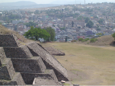
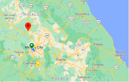
The municipality is located in the south of the Mezquital Valley in the southwest of the state of Hidalgo. With an extension of 305.8 km2 it borders the municipalities of Tepetitlán, Tlahuelilpan, Tepeji del Río, Atotonilco de Tula, Atitalaquía and Tlaxcoapan, with the State of Mexico to the west.
The city of Tula has an altitude of 2,020 meters above sea level Most of the municipality is semi flat with only one significant elevation completely in the municipality known as Magoni. Elevations in the west form the border between it and the State of Mexico. These include Magueni and La Malinche. In the north there is a small mountain of volcanic origin called Xicuco.
Surface water is mostly found in the Tula River, the Rosas River and the Arroyo Grande, whose waters are stored in the Endho Dam. The Tula River begins with the discharge from the Valley of Mexico which pass north through the State of Mexico before reaching the area. The Rosas River also begins in the State of Mexico but with clean waters from a fresh water spring. It has carved some small canyons in the area.
The municipality's climate varies from temperate to cold with an average annual temperature of 17.6 °C (63.7 °F). It has an average annual rainfall of 699 mm (27.5 in), with most rain falling from May to September.
The natural vegetation is mostly semi desert, with cactus and maguey plants the most defining followed by mesquite and the pirul tree (Schinus molle) along with seasonal grass. Native fauna includes rabbits, squirrels, chameleons, roadrunners, coyotes, various kinds of birds and snakes, skunks and opossums.
Pollution problems generally come from the PEMEX refinery and the discharge of wastewater from the Valley of Mexico into the Tula River.
Weather
Köppen Classification: Tropical and Subtropical Steppe Climate
This climate type occurs primarily on the periphery of the true deserts in low-latitude semiarid steppe regions. It is transitional to the tropical wet-dry climate on the equatorward side and to the mediterranean climate on its poleward margin, with a cooler, wetter winter resulting from the higher latitude and mid-latitude frontal cyclone activity. Annual precipitation totals are greater than in tropical and subtropical desert climates. Yearly variations in amount are not as extreme as in the true deserts but are nevertheless large.
The Köppen Climate Classification subtype for this climate is "BSk". (Tropical and Subtropical Steppe Climate).
The average temperature for the year in Tula de Allende is 64.9°F (18.3°C). The warmest month, on average, is May with an average temperature of 70.9°F (21.6°C). The coolest month on average is January, with an average temperature of 57.6°F (14.2°C).
The highest recorded temperature in Tula de Allende is 99.3°F (37.4°C), which was recorded in May. The lowest recorded temperature in Tula de Allende is 21.2°F (-6°C), which was recorded in February.
The average amount of precipitation for the year in Tula de Allende is 22.1" (561.3 mm). The month with the most precipitation on average is July with 4.7" (119.4 mm) of precipitation. The month with the least precipitation on average is February with an average of 0.2" (5.1 mm). In terms of liquid precipitation, there are an average of 84.0 days of rain, with the most rain occurring in July with 14.9 days of rain, and the least rain occurring in January with 2.3 days of rain.
Getting there and around
There are at least 1-2 buses every hour from Mexico City's Northern Bus Terminal (Autobuses del Norte) to Tula's bus station, which is located in Xicoténcatl Street.
You can also rent a car to travel to Tula from Mexico City, Pachuca or some other nearby city, but you’d probably have to go to deliver it back to that city or some other close one.
One-way rentals are ideal if you are planning to fly out of a different city from the one you arrive in. They are a convenient way to take a longer, more extensive road trip and not have to back-track. On the flip side, some trips may make more sense to do as a round-trip drive. Compare availability and rates between various options and see what works best with your plans.
https://www.enterprise.com/en/road-trips/things-to-consider-when-renting-a-car-for-a-road-trip.html
Get around
From the bus station, you can easily walk to the city center (Cinco de Mayo St, Zaragoza St, Quetzalcoatl St). From there, you can walk north on the pleasant pedestrian Quetzalcoatl St until the little pedestrian bridge over the Tula River. From the bridge, it is only a short walk, with good views, to the southern, pedestrian gate of the Tula Archaeological Area. As of the late 2013, that southern gate is usually closed; the main (northeastern) gate is about a mile away, and while you can walk there (along Avenida del Tesoro and Boulevard Tula), the walk is not pleasant.
There are some city buses, including a route that passes near the bus terminal (the bus stop is called "Elektra") and near the archaeological zone's main entrance (the stop is in Boulevard Tula, near the turn off to the archaeological zone).
Uber is expanding rapidly across Mexico and now offers services in cities across the country, including: Mexico City, Toluca, Cuernavaca, Puebla, Querétaro, León, Aguascalientes, San Luis Potosí, Guadalajara, Monterrey, Hermosillo, Tijuana, Mexicali, and Mérida. Uber has been adding Mexican cities to its network every year, check for availability when you arrive at your destination in Mexico.
Cabify is developing also and currently operates in cities including Mexico City, Toluca, Monterrey, Puebla, Querétaro and Tijuana. Check for availability in the city you are visiting.
The services offers people with smartphones a way to book a cab through a mobile app for a pre-agreed price. Fares are comparable with Sitio type cabs (see above), and sometimes trade at a premium to this when local demand increases.
https://www.mexperience.com/transport/taxi-travel-in-mexico/#51
3. Economy
GDP: 7M MXN
4. Industry
The city and municipality have a very low level of socioeconomic marginalization but median household income varies between US$10,641 and $5,037 a year. The city is a regional economic center. The nucleus of its economic sphere includes the municipalities of Tula de Allende, Atitalaquuia, Atotonilco de Tula, Chapantongo and Nopala de Villagrán. Other municipalities which are affected include Tepetitlán, Tepeji del Río, Tlahualilpan, Tlaxcoapan, Tezontepec de Aldama, Soyaniquilpan de Juárez and Jilotepec.
Of the economically active population (minus students and retirees), just under ten percent work in agriculture and livestock; just over 33 percent work in manufacturing and mining and about 55 percent work in commerce, services and tourism. 97% of the land is held in common, generally in ejidos, for agricultural purposes. The main crops are corn, beans, oats, wheat, vegetables such as squash, tomatillos and chili peppers, alfalfa, nopal cactus, cactus fruit, peaches and avocados. Livestock includes sheep, goats, cattle and pigs along with domestic fowl. Fishing is mostly limited to sporting catching carp and catfish.
There are firms dedicated to manufacturing, mineral extraction and construction as well as "maquiladoras". The most important of these are the Francisco Pérez Ríos Thermoelectric plant and the PEMEX refinery as well as the Cruz Azul and Tolteca cement locations. The refinery was established in 1976, and makes gasoline, diesel and solvents. It has 35 plants in eleven sections, covering an area of 707 hectares (1,750 acres). It processes just under 25% of Mexico's crude employing about 3,500 workers. The main handcraft in the city is the making of replicas of Toltec stone pieces. The altas figures are also recreated in way, marble, plastic and clay. Textiles are also made especially quezquémetl, rebozos, sarapes, hats and baskets.
Commerce is mainly for local needs such as groceries and clothing. There are two main traditional markets in the city of Tula, the municipal market and the Tianguis. The latter generally concentrates on electronics. The major service sector is related to tourism. This is mostly focused on visitors to the Tula archeological site. There is also the Requena dam (boating, fishing and picnicking) and the Parque Acuático la Cantera, a water park with a pool and thermal springs. The municipality has two four star hotels and two three star hotels.
The municipality's infrastructure includes 37 km (23 mi) of federal highway, 72 km (45 mi) of state highway, 9 km (5.6 mi) of rural highway and 40 km (25 mi) of rail line. It has a main bus terminal with local and intercity bus service. Trains that regularly pass through include the Mexico City–Ciudad Juárez line and the Mexico City-Tula-Querétaro line. It still has telegraph service, one of the oldest still in service after 100 years. Postal service in the town is also one of Mexico's oldest, beginning in 1856. There are two radio stations, FM XHLLV and “Super Stereo 90.9”.
5. Touristic sites
The Tula Measoamerican Archeological SIte
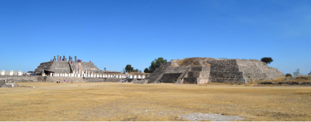
Tula was an important regional center which reached its height as the capital of the Toltec Empire between the fall of Teotihuacan and the rise of Tenochtitlan. It has not been well studied in comparison to these other two sites, and disputes remain as to its political system, area of influence and its relations with contemporary Mesoamerican cities, especially with Chichen Itza. The site is located in the city of Tula de Allende in the Tula Valley, in what is now the southwest of the Mexican state of Hidalgo, northwest of Mexico City. The archeological site consists of a museum, remains of an earlier settlement called Tula Chico as well as the main ceremonial site called Tula Grande. The main attraction is the Pyramid of Quetzalcoatl, which is topped by four 4-metre-high (13 ft) basalt columns carved in the shape of Toltec warriors. Tula fell around 1150, but it had significant influence in the following Aztec Empire, with its history written about heavily in myth. The feathered serpent god Quetzalcoatl is linked to this city, whose worship was widespread from central Mexico to Central America at the time the Spanish arrived.
The Tula site is important to the history of Mesoamerica, especially the central highlands of Mexico, but it is generally overshadowed by its predecessor Teotihuacan and one of its successors, Tenochtitlan. The name Tula is derived from the Nahuatl phrase Tollan Xicocotitlan, which means 'near the cattails'. However, the Aztecs applied the term Tollan to mean 'urban center', and it was also used to indicate other sites such as Teotihuacan, Cholula and Tenochtitlan. The inhabitants of Tula were called Toltecs, but that term was later broadened to mean an urban person, artisan or skilled worker. This was due to the high respect in which the indigenous peoples in the Valley of Mexico held the ancient civilization before the Spanish conquest of the Aztec Empire.
What remains of the ancient city is located in the southwest of what is now the state of Hidalgo, 75 km north of Mexico City. Geographically, it is in the Tula River Valley, at the south end of the Mesquite Valley in a region that indigenous records called Teotlapan (land of the gods). This area has an elevation of between 2000 and 2200 meters above sea level, with a semi-arid climate. It has only three continuously flowing rivers and streams, the largest of which is the Tula River. There are also a number of arroyos that flow during the rainy season.
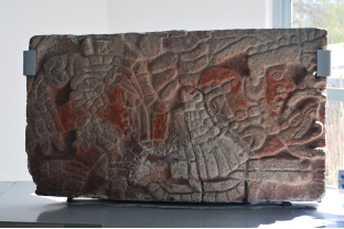
The modern archeological site consists of the ceremonial center of Tula Grande, an area called Tula Chico, the Jorge R. Acosta site museum and the Guadalupe Mastache Orientation center. The museum is at the entrance to the site and is named after one of the archeologists who worked on the site for years. The interior is organized into various sections and contains sculpted stone works as well as human remains. The Orientation center also contains a number of archeological pieces as well as posters and more explaining the site's importance and relation to the rest of Mesoamerica.
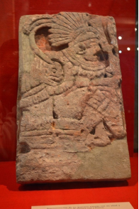
The city is aligned at 17 degrees east of true north, similar to structures at Teotihuacan although the first village was aligned with true north between 700-900CE. The ceremonial center of the city is located on a limestone outcropping, with steep banks on three sides, making it defensible. War and sacrifice are prominent themes at the site with images representing warriors such as jaguars and coyotes as well as eagles eating human hearts. There are also images of serpents eating skeletal figures and skulls in various areas. The main structures of the ceremonial center include two pyramids, including with the atlas figures, two main Mesoamerican ballcourts and several large buildings, one with a series of columns which faced a large plaza. The main ceremonial area has a number of architectural innovations that indicate societal changes. The large central plaza has space for 100,000 people. On three sides, there are long meeting halls with ceilings supported by columns all facing the plaza with over 1000 meters of benches, which have stone reliefs depicting warriors and others in procession. The architecture indicates a change from rituals performed by only a few people in closed spaces to large ceremonies to be viewed by many. These ceremonies were dominated by warriors.
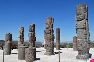
The major attraction of the site is Pyramid B also called the Pyramid of Quetzalcoatl or of the Morning Star. It is a five-tiered structure similar to the Temple of the Warriors at Chichen Itza. At the top of Pyramid B are four massive columns each carved in the likeness of Toltec warriors which once supported the roof of the temple on top of the pyramid. Each warrior figure is of basalt, four meters high, with an atlatl or spear thrower, incense, a butterfly shaped chest plate and a back plate in the shape of a solar disk. A large vestibule fronts the pyramid and connects it to nearby buildings. Today this vestibule and building (Building C) are a space filled with broken columns. Building C is better known as the Burnt Palace named after evidence that it was burned. This pyramid is also surrounded by the Coatepantli or serpent wall, which was later the inspiration for a similar structure in Tenochtitlan.
The earliest well-defined settlements in the Tula area appear around 400 BCE. Tula was probably settled by people of various ethnic backgrounds which may have included the Nonoalcas and the Chichimecas from the south and north respectively. The area probably was under the political control of Teotihuacan in the Epiclassic period, according to Teotihuacan designs found on Tula pottery. The area's lime deposits were probably an important source for the plaster used in construction. At this time Tula was a small urban settlement with modest public architecture concentrated at Tula Chico (Small Tula). The constructions at Tula Chico are smaller than those in other Epiclassic sites, and was probably a minor player in the political and economic activity of the time. Tula Chico's occupation is from 650 to 900. From 650 to 750, Tula Chico developed, and at its height spanned five to six km2, parts of which may be buried under Tula Grande. The population was somewhere between 19,000 and 27,000 at its height. Tula Chico was abandoned between 850 and 900CE, and Tula Grande began to develop. After the decline of Teotihuacan, there was a power vacuum with city states dominating small regions. Tula ceramics change during this period, as styles and techniques come under new influences. At the same time, settlement patterns of the area significantly changed with occupation mostly on hilltops and high hillsides. Architecture and pottery show influence from the west and north, with some from the east, suggesting a multiethnic population.
The city rose to prominence after the fall of Teotihuacan and reached its height between 900 and 1150. Although Tula Grande (Big Tula) grew to be larger than anything contemporary with it, it never grew to the size of Teotihuacan. The city at its height probably covered 14km2 with a population of about 60,000 with another 20,000 to 25,000 in the surrounding 1000km2, dominated by the ceremonial center of Tula Grande. Urban and rural house units indicated the importance of extended family groups but the scale of these seemed to have become smaller over time. Tula had defensive fortification at Las Ranas and Toluquilla against the Chichimecas. Its political sphere is thought to include most of the present state of Hidalgo, into the Valley of Mexico and possibly into the Toluca Valley and the Bajío. Much of this is done by comparison of ceramics but this can indicate political or economic influence.
6. History and Culture
The name is derived from the Nahuatl phrase Tollan-Xicocotitlan, which means near where cattails grow. Tula is the Hispanicized pronunciation of Tollan. In Otomi the area is called Namehi, which means “place of many people.” It was given the appendage of “de Allende” in honor of Ignacio Allende who fought in the Mexican War of Independence.
The area was the capital of one of the major civilizations of Mesoamerica, that of the Toltecs. The Toltecs rose to power after 713 CE as the successor to Teotihuacan. The current city is centered just south of the ceremonial center of the ancient city, which is famous for its Atlantean figures. The Toltec Empire reached as far south as the Valley of Mexico and its influence has been found in artifacts as far away as the current U.S. Southwest. It is believed that aguamiel was first extracted around 1100CE, which led to the making of pulque. The last Toltec ruler was Topilzin Ce-Acatl Quetzalcoatl who came to power in 1085.
After the Spanish conquest of the Aztec Empire, Pedro Miahuazochil was named in 1531 as the lord of Tula helping to evangelize the area.
Tula became a municipality in 1871.
The Tula area was the scene of various battles during the Mexican Revolution, particularly between those loyal to Venustiano Carranza and those to Emiliano Zapata.
7.Contact Information
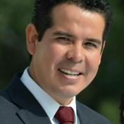
City Mayor: Ismael Gadoth Tapia Benítez
Contact number: +52 (773) 732 0002
Govt. Office Address: Plaza del Nacionalismo S/N, C.P. 42800 Tula de Allende, Tula de Allende, México
Twitter: https://twitter.com/GadothT
FB: https://www.facebook.com/Gobierno-Municipal-de-Tula-Hidalgo-1214658955244179
Website: http://www.tula.gob.mx
