Tijuana, Baja California 作者: 来源: 发布时间:2021-07-22
1.asic data
Population: 1,902,385 (2019, city)
Metropolitan Area: 2,096,784 Area: 637 km2

2. Natural geography
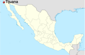
Tijuana is the westernmost city in Mexico, and consequently in Latin America, and the second largest city of northern Mexico. Located about 210 kilometers (130 mi) west of the state capital, Mexicali, the city is bordered to the north by the cities of Imperial Beach, and the San Diego neighborhoods of San Ysidro and Otay Mesa, California. To the southwest of the city is Rosarito Beach, while to the south is unincorporated territory of Tijuana Municipality. The city is nestled among hills, canyons, and gullies. The central part of the city lies in a valley through which flows the channeled Tijuana River.
Housing development in the Tijuana Hills has led to eradication of many seasonal mountain streams. This lack of natural drainage makes places within the city vulnerable to landslides during the rainy season. The varied terrain of Tijuana gives the city elevation extremes that range from sea level to 790 meters (2,590 ft).
Tijuana is noted for its rough terrain, which includes many canyons, steep hills, and mesas. Among noted canyons in Tijuana are Canyon K and Canyon Johnson. Large Tijuana hills include Red Hill (Cerro Colorado) and Hill of the Bees (Cerro de las Abejas) in the eastern part of the city.
The city is located near the terminus of the Tijuana River and within the Tijuana River Basin. The Tijuana River is an intermittent river, 195 km (121 mi) long, on the Pacific coast of northern Baja California in Mexico and Southern California in the United States. It drains an arid area along the California–Baja California border, flowing through Mexico for most of its course and then crossing the border for the last 8 km (5 mi) of its course where it forms an estuary that empties into the ocean. The river's lower reaches harbor the last undeveloped coastal wetlands in San Diego County, and some of the last in Southern California, amidst a highly urbanized environment at the southern city limits of Imperial Beach.
As downtown Tijuana was built at the bottom of the river valley, the district is subject to seasonal flooding created by drain-off from the Tijuana Hills. During this time, east-bound portions of the Via Rapida (east-west highway) may be blocked off by the Tijuana Police due to hazardous conditions.
Weather
Tijuana's climate is a semi-arid (Köppen climate classification BSh), with about 231 mm (9.09 in) of annual precipitation, and generally mild to warm weather year-round. It has characteristics of the Mediterranean climate (Csa) found to the immediate north, with most of the annual precipitation falling in the winter, between the months of November and March.
Between November and March, storms originate from fronts entering off of the Pacific Ocean. January is the wettest month of the year for the city and during this time a periodic event, similar to June Gloom, is observed created by marine layer. January is the coolest month, during which temperatures average 13.6 °C (56.5 °F). In the city April signifies the end of winter and the start of Santa Ana winds. Though the daytime highs are generally around 20 °C (68 °F), heat waves can reach up to 33 °C (91 °F). The hottest months in the city are August and September, during which temperatures average 22.0 °C (71.6 °F). Summers are by far the driest time of year since influences from the California Current and the North Pacific High suppress the formation of rainfall caused by the North American Monsoon. As in coastal Southern California, air pollution sometimes occurs during periods of temperature inversion, especially during summer and fall, but (unlike Mexico City) is seldom severe and in recent years has lessened due to cleaner car engines.
Frost and snow are rare phenomena in the city as temperatures are usually well above freezing. Yet, in December 1967, snow fell in the city and in January 2007 feather light snow fell in the east of the city. However, excessive amounts of snow fall have never been recorded in the city. On February 14, 2008 a winter storm caused an unusual snowfall in the upper reaches of the hills of the city.
The record low temperature recorded in the city was −6 °C (21 °F), while the highest was 49 °C (120 °F).
Getting there and around
Mexican immigration requires that visitors have passports that are valid for at least 6 months. American and Canadian tourists do not require a visa or a tourist card for stays of 72 hours or less within the border zone (20-30km/12-19 miles from the U.S. border). For travel to Mexico beyond the border zone, Americans must be in possession of a tourist card, also called a Tourist Migration Form (FMM). This document is provided by immigration authorities at the country's points of entry. If you enter Mexico by land, and will be going beyond the border zone or staying there more than 72 hours, it is your responsibility to stop at the immigration module located at the border.
By Plane -- The Tijuana Airport (tel. 664/607-8201) is about 8km (5 miles) east of the city. All Mexican airlines (Aeroméxico, Volaris, Interjet, and VivaAerobus.com) fly to Tijuana from points within Mexico. To fly from other countries, you'll fly to San Diego's Lindbergh Field in California (tel. 619/400-2404 in the U.S.; www.san.org), about an hour from Tijuana, which has nonstop and connecting flights from all over the United States.
Official taxis from Tijuana's airport cost 200 to 250 pesos to centro or Zona Río; buy tickets from the booth near the exit. From San Diego's airport, take the 992 bus ($2.25) or a cab (about $10) the 5 minutes to Santa Fe train station and take the Trolley to the border to walk across.
By Car -- To drive to Tijuana from the U.S., take highways I-5 or 805 S. to the Mexican border at San Ysidro. The drive from downtown San Diego takes about 30 minutes, or you can leave your car in a San Ysidro parking lot and walk the 20 minutes to Avenida Revolución.
If you choose to leave your car behind, which may be a wise decision since traffic is challenging, you can take the San Diego Trolley to the San Ysidro border. From there you can follow the signs to walk across the border, or hop one of the buses (tel. 664/685-1470), which are located next to the trolley station. Once you're in Tijuana, it's easy to get around by taxis, which are still relatively safe compared to those in other large cities like Mexico City. Cab fares from the border to downtown average 50 pesos. You can also hire a taxi to Rosarito for about 200 pesos one-way.
By Bus -- Greyhound Bus Lines (tel. 800/231-2222 in the U.S.; www.greyhound.com) offers service nearly 24 hours daily for $13 one-way between San Diego and Tijuana via the San Ysidro border crossing, stopping at Tijuana's Rodriguez airport (TIJ) and ending up at Tijuana's Central de Autobuses, where you can connect to Mexican bus lines for destinations farther down Baja. Mexicoach (tel. 619/428-9517 in the U.S., or 664/685-1470 in Mexico) runs a similar service (hourly, 5am-10pm) between San Ysidro and Tijuana for $4 one-way/$6 round-trip. For $13 one-way/$20 round-trip, it will take you as far as Rosarito. Mexican discount airliner Volaris also runs a shuttle between San Diego's Santa Fe train station and Tijuana airport for passengers; cost is $15.
By Trolley -- From downtown San Diego, you have the option of taking the bright-red Tijuana Trolley (tel. 619/595-4949; www.sdmts.com) headed for San Ysidro and getting off at the last, or San Ysidro, stop. It's simple, quick (about 1 hr. from Old Town San Diego to San Ysidro), and inexpensive; the one-way fare is $2.50. The last trolley leaving for San Ysidro departs downtown San Diego around midnight; the last returning trolley from San Ysidro is at 1am. On Saturday, the trolley runs 24 hours. From the trolley station, just walk over the border.
https://www.frommers.com/destinations/tijuana/planning-a-trip/getting-there#:~:text=Once%20you're%20in%20Tijuana,%2D%2D%20Greyhound%20Bus%20Lines%20(tel.
3. Economy
The GDP/capita in 2013 was of 10,119 USD.
http://monitoreconomico.org/noticias/2014/apr/11/crecio-participacion-de-tijuana-en-el-pib-total-del-estado/
4. Industry
Manufacturing
Tijuana is a large manufacturing center, and in addition to tourism, it serves as a cornerstone of the city economy. In the past decade alone, Tijuana became the medical device manufacture capital of the North American continent, surpassing previous leader Minneapolis - Saint Paul.
The city's proximity to Southern California and its large, skilled, diverse, and relatively inexpensive workforce make it an attractive city for foreign companies looking to establish extensive industrial parks composed of assembly plants that are called maquiladoras, even more so than other cities in the US-Mexican border zone, taking advantage of the North American Free Trade Agreement (NAFTA) to export products. At its peak, in 2001 Tijuana had roughly 820 of these 'maquiladoras'. Foreign and domestic companies employ thousands of employees in these plants, usually in assembly-related labor. Such jobs are not demanding but typically offer above average salaries for Mexico, with most maqiladoras jobs beginning at Mex$100 per day (about 5 US dollars, as of September 2016), significantly above the Mexican minimum wage of Mex$57.46 (about 3 US dollars, as of September 2016). Companies that have set up maquiladoras in Tijuana include Lanix, Hyundai, Sony,[52] Vortec, BMW, Vizio, Toyota, Dell, Samsung, Kodak, Matsushita/Panasonic, GE, Nabisco, Ford, Microsoft, Cemex, Zonda, Philips, Pioneer, Airbus, Plantronics, Siemens Mexico, Jaguar, Pall Medical, Tara, Sanyo and Volkswagen. Many of the maquiladoras are located in the Otay Mesa and Florido sections of Tijuana. Economic development has its central business district at Zona Río, which together, with the corridor along Blvd. Agua Caliente (the extension of Avenida Revolución), contains the majority of the higher-end office space in the city.
Tourist economy and entertainment
Tijuana also relies on tourism for a major part of its revenue. About 300,000 visitors cross by foot or car from the San Ysidro point of entry in the United States every day. Restaurants and taco stands, pharmacies, bars and dance clubs, and shops and stalls selling Mexican crafts and souvenirs are part of the draw for the city's tourists, many located within walking distance of the border. The city's tourist centers include Downtown Tijuana including the nightlife hot spots around La Sexta, Avenida Revolucion, souvenir shopping at the Mercado de Artesanías and Plaza Viva Tijuana, Tijuana's Cultural Center (CECUT) and neighboring Plaza Río Tijuana shopping center, and the city's best known vices, in the form of its legal Red Light District and gambling (Agua Caliente). Mexico's drinking age of 18 (vs. 21 in the United States) makes it a common weekend destination for many high school and college aged Southern Californians who tend to stay on Avenida Revolución.
Tijuana is also known for its red-light district Zona Norte (also referred to as La Coahuila after one of its main streets) with legal prostitution in strip clubs and on the street. The strip clubs are typically full-contact, meaning the dancers let patrons fondle them. Many dancers also sell their sexual services. In a 1999 estimation, there were 15,000 women engaged in prostitution in Tijuana outside of clubs and brothels.
Tijuana has many pharmacies that target visitors from the United States, which sell some medicines without prescriptions and/or at much lower costs than in the U.S. Many medications still require a Mexican prescription, which can be obtained from adjacent doctors' offices. People filling up prescriptions for drugs classified in the US as Schedule II or Schedule III have found it more difficult to locate such medications, and the purchase of pseudoephedrine also has become restricted by Tijuana pharmacies, just as in the U.S. To fill a prescription in Tijuana for any drug covered by the US Controlled Substances Act and legally bring it into the United States requires a prescription from the United States for re-import. Americans can import up to a 90-day supply of non-controlled medications for personal use to the USA from Mexico and other countries.
Businesses such as auto detailing, medical and dental services and plastic surgery are heavily marketed, and are usually much less expensive than in the U.S.
Tijuana is headquarters for Mexico's largest gambling concern, Grupo Caliente, which operates the only casinos in the city, more than twenty branches.
Tourists are sometimes robbed by municipal police.
Retail
Plaza Rio Tijuana is a large regional mall anchored by Cinépolis, Sanborns, Súper DAX and Sears.
All across the city, there are dozens of plazas comerciales, which may be strip malls or small enclosed or open-air centers. An important concentration of plazas is in the Cinco y Diez around an eponymous intersection, named for a former American-style five and dime store that was located there. It is also a major hub for public transit. Plaza Carrousel, with its namesake merry-go-round, is located here.
Costco, Sam's Club, and Walmart each have multiple branches across the city.
Traditional markets with vendors include the large Mercado Hidalgo in Zona Río, smaller neighborhood markets and the Mercado Municipal downtown.
Tijuana was the headquarters of 14-store Dorian's department store chain until its demise in 2009; most were converted to Sears stores.
Culinary
Tijuana, along with the nearby Valle de Guadalupe, has recently become a culinary hotspot due to its Baja Med cuisine, including chefs such as Javier Plascencia, but also for its tacos, other street food, food trucks, coffee houses and artisanal beer.
Tijuana-Tecate light-train
A project for an Interurban Tijuana Train of 27.4 kilometers that would run along the train track from the San Ysidro gate to the limits with Tecate in the eastern zone, was presented by the company "Nolte de México" to the state governor, Jaime Bonilla Valdez.
The project, which focuses on the use of the existing track and which is currently only used by US locomotives as they pass through the municipalities of Tijuana and Tecate, would have a use of 27.4 kilometers with two stations; one in the vicinity of the San Ysidro checkpoint and the second in the Maclovio Rojas neighborhood to the east of the city.
With an approximate cost of 2,836 million pesos and with the participation of the private sector and the three levels of government, this project is based on the reorganization of the routes that could serve as passenger feeders for the light rail.
The reorganization would include the area of Colonia Libertad and Colonia Del Río, most of the La Mesa sector, Los Pinos, Presa and the Ojo de Agua and Presa Rural delegations.
https://jornadabc.mx/tijuana/05-05-2020/presentan-actualizacion-de-tren-ligero-cruzara-de-tijuana-hasta-tecate
5. Touristic sites
Tijuana Cultural Center (CECUT)
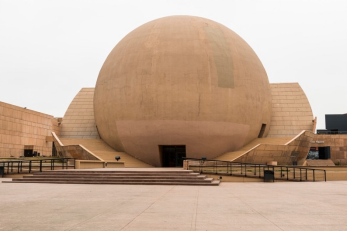
East of Tijuana’s downtown is the more affluent Zona Río by the Tijuana River.
Just next to the Plaza Río pedestrian mall is the Cultural Center, which opened in 1982. Designed by the eminent renowned architect Pedro Ramírez Vázquez, the centre has become a symbol for Tijuana.
The building that stands out the most is “La Bola”, the spherical structure housing Tijuana’s only IMAX cinema, premiering four high-resolution movies each year.
The centre also has a well-curated exhibition about California, which we’ll talk about next, a botanic garden, aquarium, cafe and a spacious esplanade.
One of the newer facilities is “El Cubo”, which opened in 2008 and stages international art exhibitions.
Avenida Revolución
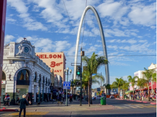
Most visitors with limited time make Avenida Revolución in Zona Centro their first port of call.
Like many downtowns in the United States, Avenida Revolución is a little grimy, but is home to some real icons like Caesar’s which we’ll talk about below in “Local Food”. For roughly eight blocks there’s nothing but restaurants, souvenir shops and bars.
At the upper end is Plaza Santa Cecilia, near the Tijuana Arch and where there are roving “conjuntos norteños” musicians, dozens of outdoor stalls selling clothes and arts and crafts, and no lack of street food stands either if you’re in the mood for a huarache, tostada or quesadilla.
Tijuana Beaches
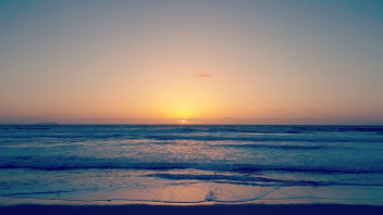
Tijuana’s westernmost borough is a residential area ending at the ocean.
So you could head out here if you want a taste of the Pacific on Mexican soil without making the trip down to better known beach resorts like Ensenada and Rosarito.
As the name suggests, Playas de Tijuana has beaches; in fact, it’s one long beach that continues south from the border fence for around four kilometres to Puente la Joya.
The sand is kept clean, the gradient is light and the waves roll in around waist height.
On weekends there will be families wandering along the Malecón (raised promenade) behind, and grab some seafood specialities like octopus with rice, ceviche, fish tacos and camarones cucaracha (shrimp with a spicy tomato and lemon sauce).
Californias’ Museum
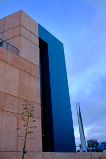
The central building at the Tijuana Cultural Center houses a permanent exhibition to give you a real sense of place in California.
Stop here for a few minutes of reflection before scooting off for Tijuana’s more lurid pleasures.
The museum charts the human and natural history of the California peninsula.
On a helical ramp, you’ll begin in prehistoric times and work your way to the middle of the 20th century via the Jesuits, War of Independence and Revolution.
There are reproductions of the rock paintings found in the Sierra de San Francisco, dioramas of the Cochimí and Yuman native groups as well as examples of folk art, artefacts from the old Desert Line railroad, models of pre-Hispanic settlements, examples of New Spanish metalwork and a detailed large scale model of a Spanish carrack.
https://www.thecrazytourist.com/15-best-things-to-do-in-tijuana-mexico/
7. History and Culture
Origins
The land was originally inhabited by the Kumeyaay, a tribe of Yuman-speaking hunter-gatherers. Europeans arrived in 1542, when the explorer Juan Rodríguez Cabrillo toured the coastline of the area, which Sebastián Vizcaíno mapped in 1602.
In 1848, as a result of the Mexican–American War with the United States, Mexico lost all of Alta California. The majority of the 1,000 Hispanic families living in Alta California stayed there, though some moved south to remain inside Mexico. Because of this Tijuana gained a different purpose on the international border. The area had been populated by ranchers, but Tijuana developed a new social economic structure. These were farming and livestock grazing, plus as a transit area for prospectors.
1889–1915: Town established
Urban settlement began in 1889, when descendants of Santiago Argüello and Agustín Olvera entered an agreement to begin developing the city of Tijuana. The date of the agreement, July 11, 1889, is recognized as the founding of the city. Tijuana saw its future in tourism from the beginning. From the late 19th century to the first few decades of the 20th century, the city attracted large numbers of Californians coming for trade and entertainment. The California land boom of the 1880s led to the first big wave of tourists, who were called "excursionists" and came looking for echoes of the famous novel "Ramona" by Helen Hunt Jackson.
In 1911, during the Mexican Revolution, revolutionaries claiming loyalty to Ricardo Flores Magón took over the city for shortly over a month. Federal troops then arrived. Assisted by the "defensores de Tijuana", they routed the revolutionaries, who fled north and were promptly arrested by the United States Army.
The Panama-California Exposition of 1915 brought many visitors to the nearby California city of San Diego. Tijuana attracted these tourists with a Feria Típica Mexicana – Typical Mexican Fair. This included curio shops, regional food, thermal baths, horse racing and boxing.
1916–1935: Gambling and drinking destination
The first professional race track opened in January 1916, just south of the border gate. It was almost immediately destroyed by the great "Hatfield rainmaker" flood of 1916. Rebuilt in the general area, it ran horse races until the new Agua Caliente track opened in 1929, several miles south and across the river on higher ground.
Legal drinking and gambling attracted U.S nationals in the 1920s during Prohibition. The Avenida Revolución area became the city's tourist center, with casinos and the Hotel Caesar's, birthplace of the Caesar salad.
In 1925, the city by presidential decree changed his name to ciudad Zaragoza, but its name reverted to Tijuana in 1929.
In 1928, the Agua Caliente Touristic Complex was opened, including hotel, spa, dog-track, private airport, golf course and gambling casino. A year later, the new Agua Caliente Racetrack joined the complex. During the eight years it operated, the Agua Caliente hotel, casino and spa achieved a near mythical status, with Hollywood stars and gangsters flying in and playing. Rita Hayworth was discovered there. Musical nightclub productions were broadcast over the radio. A singer known as "la Faraona" got shot in a love-triangle and gave birth to the myth of a beautiful lady ghost. Remnants of the Agua Caliente casino can be seen in the outdoor swimming pool and the "minarete" (actually a former incinerator chimney) nearby the southern end of Avenida Sanchez Taboada, on the grounds of what is now the Lazaro Cardenas educational complex.
1935–1965: Tourism broadens
In 1935, President Cárdenas decreed an end to gambling and casinos in Baja California, and the Agua Caliente complex faltered, then closed. In 1939, it was reopened as a junior high school (now, Preparatoria Lázaro Cárdenas). The buildings themselves were torn down in the 1970s and replaced by modern scholastic architecture.
With increased tourism and a large number of Mexican citizens relocating to Tijuana, the city's population grew from 21,971 to 65,364 between 1940 and 1950.
With the decline of nightlife and tourism in the 1950s, the city restructured its tourist industry, by promoting a more family-oriented scene. Tijuana developed a greater variety of attractions and activities to offer its visitors.
1965–2001: The city matures
In 1965 the Mexican federal government launched the Border Industrialization Program to attract foreign investment. Tijuana and other border cities became attractive for foreign companies to open maquiladoras (factories), and the Tijuana economy started to diversify. Manufacturing jobs attracted workers from other parts of Mexico and the city's population grew from less than half a million in 1980 to almost 1 million in 1985.
In 1972, work began on the first concrete channeling of the Tijuana River; previously the river would flood across a wide plain east and southeast of downtown, inundating an area of wood, cardboard and metal shacks called Cartolandia (“Paperland”). The project removed the shacks and added 1.8 million sq. m. of usable land, on which the Zona Río was built. With the 1981 opening of the Plaza Río Tijuana mall and the 1982 Tijuana Cultural Center (CECUT), Zona Río became the new commercial center of a modern Tijuana, and with its new boulevards with monument-filled glorietas (roundabouts), reminiscent of the grand Paseo de la Reforma in Mexico City, the city created the new image and allure of a modern, large city, rather than just a border town focused on tourism and vice.
In 1994, PRI presidential candidate Luis Donaldo Colosio was assassinated in Tijuana while making an appearance in the plaza of Lomas Taurinas, a neighborhood nestled in a valley near Centro. The shooter was caught and imprisoned, but doubts remain about who the mastermind might have been.
2001–2011: Violence and decline of US tourism
After 9/11, tighter US border controls resulted in hours-long waits to return to the US. The number of US visitors dropped sharply due to this factor, as well as subsequent drug violence.
Around 2008, thousands of Tijuana's elite bought houses in and moved to Bonita and Eastlake in Chula Vista, California to escape violence, kidnapping and other crimes taking place during that period. An article in The Los Angeles Times reported that the emigration to San Diego County has transformed the demographic and cultural character of some cities to a degree.
2011–present: Tijuana strengthens
In recent years, Tijuana has become an important city of commerce and migration for Mexico and US. In spite of the violence and border crossing issues, the city has received a large number of tourists from US, China, Japan and the south of Mexico. Thanks to the realization of cultural and business festivals, the city has improved its image before the world, standing out as a competitive city for investment. Currently, the commercial and business sector is committed to the boom in the gastronomic industry, craft beer, entertainment and real estate, as well as medical tourism, to attract visitors and investors.
7. Contact Information
City Mayor: Arturo González Cruz
Contact number: +52 (664) 973 7025, ext. 7023
Govt. Office Address: Blvd. Independencia 1350, Zona Urbana Rio Tijuana, 22320 Tijuana, B.C.
Facebook: https://www.facebook.com/arturogonzalezbc/
Twitter: https://twitter.com/ArturoG_BC
